


South Hooksett, New Hampshire
South Hooksett is a community of 5,902 people in Merrimack County, New Hampshire.
Why visit South Hooksett
Townapedia lists 40 museums and landmarks, 11 parks and trails, 48 places to eat, 2 places to stay and 10 attractions in and around town.
Highlights include McIntyre Ski Area, Palace Theatre, Currier Museum of Art and Stark Park.
July is the warmest month, with average highs of 81°F; January lows average 13°F, and about 53 inches of snow fall in a normal year.
Weather in South Hooksett
Forecast from the National Weather Service. Full forecast
About South Hooksett
South Hooksett is a census-designated place (CDP) within the town of Hooksett, New Hampshire, United States. The population was 5,888 at the 2020 census. It is a suburban area adjacent to the city of Manchester, New Hampshire's largest city, and includes a mix of housing developments and large retail stores.
From the Wikipedia article South Hooksett, New Hampshire (this version), under CC BY-SA 4.0.
Things to do10

McIntyre Ski Area
Ski area · 1.7 mi
Ski area in New Hampshire, United States
50 Chalet Court, Manchester

Palace Theatre
Cinema and theater · National Register of Historic Places · 3.1 mi
Theater and former movie theater in Manchester, New Hampshire, United States

Amoskeag Falls
Waterfall · 2.9 mi
Canal in New Hampshire, United States of America

Hellenic American University
School · 3.0 mi
University in Manchester, New Hampshire, United States
University of New Hampshire at Manchester
School · 3.2 mi
Urban campus of the University of New Hampshire in Manchester, New Hampshire, United States

Farm & Flower Market
Farm and orchard · 2.4 mi
15 Webster Street, Manchester
Mo-Su 07:00-19:00


Museums and landmarks40

Currier Museum of Art
Museum · National Register of Historic Places · 2.5 mi
Art museum in Manchester, New Hampshire, United States
150 Ash Street, Manchester
We-Su 10:00-17:00; Mo,Tu off

Stark Park
Monument and historic site · National Register of Historic Places · 2.3 mi
Historic park in Manchester, New Hampshire, USA
550 River Road, Manchester

Weston Observatory
Monument and historic site · National Register of Historic Places · 1.9 mi
Listed on the National Register of Historic Places

Alpheus Gay House
Monument and historic site · National Register of Historic Places · 2.6 mi
Manchester, New Hampshire

America's Credit Union Museum
Monument and historic site · National Register of Historic Places · 3.5 mi
Historic bank museum in Manchester, New Hampshire, United States
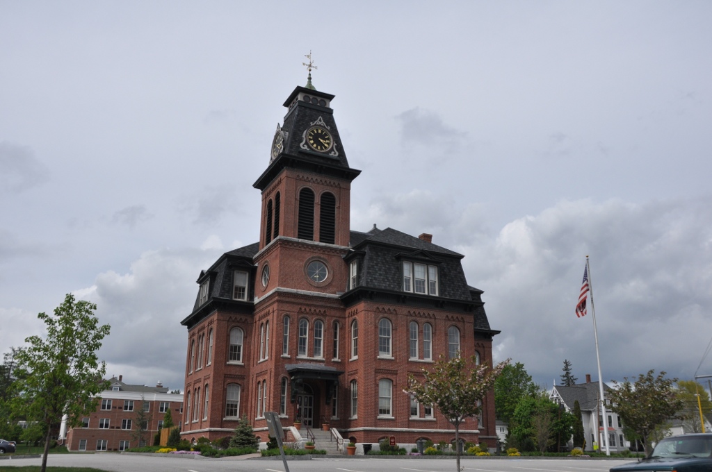
Ash Street School
Monument and historic site · National Register of Historic Places · 2.6 mi
Historic school building in Manchester, New Hampshire, USA

Carpenter and Bean Block
Monument and historic site · National Register of Historic Places · 2.8 mi
Historic apartment house at 1382-1414 Elm Street in Manchester, New Hampshire

City Hall
Monument and historic site · National Register of Historic Places · 3.1 mi
City hall in Manchester, New Hampshire

District A
Monument and historic site · National Register of Historic Places · 3.5 mi
Historic district in New Hampshire, United States

District B
Monument and historic site · National Register of Historic Places · 3.3 mi
Historic district in New Hampshire, United States
District C
Monument and historic site · National Register of Historic Places · 3.0 mi
Historic district in New Hampshire, United States


District D
Monument and historic site · National Register of Historic Places · 2.8 mi
Historic district in New Hampshire, United States
28 more on the map.
Parks, trails and playgrounds11



Restaurants and cafes48

Block Party Social
Diner · American · 0.9 mi
51 Zapora Drive, Hooksett
Su-Th 10:00-22:00; Fr-Sa 10:00-24:00

Moe Joe's
Restaurant · American, Breakfast, Lunch, Dinner · 2.4 mi
2175 Candia Road, Manchester
Mo-Th 06:00-22:00; Fr-Sa 06:00-23:00; Su 07:00-21:00
Mr. Mac's
Restaurant · Pasta, American · 1.6 mi
497 Hooksett Road, Manchester
Mo-Th 11:00-21:00; Fr-Sa 11:00-22:00; Su 11:30-21:00
Nadeau's Subs
Restaurant · Sandwich · 1.4 mi
673 Hooksett Road, Manchester
Su-Th 11:00-19:30; Fr-Sa 11:00-20:00
Pizza 911
Restaurant · Pizza, Sandwich, Pasta · 2.2 mi
110 Webster Street
Su-Th 10:30-23:00, Fr-Sa 10:30-26:00
Shorty's Mexican Roadhouse
Restaurant · Mexican · 1.2 mi
1050 Bicentennial Drive, Manchester
Su-Th 11:30-21:00; Fr-Sa11:30-22:00
The Puritan Backroom
Diner · American · 1.8 mi
245 Hooksett Road, Manchester
Su-Th 10:00-21:00; Fr-Sa 09:00-21:30
Zizza Authentic Pizzeria
Restaurant · Pizza · 1.3 mi
1100 Bicentennial Drive, Manchester
Mo-Th 11:00-20:00; Fr-Sa 11:00-21:00; Su 11:00-20:00

Auburn Pitts
Restaurant · 2.5 mi
167 Rockingham Road, Auburn
Mo-We 11:00-21:00; Th-Sa 11:00-22:00; Su 11:00-20:00
36 more on the map.
Where to stay2
Churches and places of worship14
Gethsemane Lutheran Church
Church · Lutheran · 2.5 mi
60 Pennacook Street, Manchester
Shopping10
Gas and EV charging12
Schools, colleges and libraries41
Healthcare10
Map of South Hooksett
198 places. The map loads OpenStreetMap tiles when you open it.
Climate by month
Monthly table
| Month | High | Low | Rain | Snow |
|---|---|---|---|---|
| Jan | 32°F | 13°F | 2.7 in | 15.9 in |
| Feb | 35°F | 15°F | 2.7 in | 17.6 in |
| Mar | 43°F | 24°F | 3.2 in | 6.7 in |
| Apr | 56°F | 35°F | 3.5 in | 0.9 in |
| May | 67°F | 46°F | 3.4 in | 0.0 in |
| Jun | 76°F | 56°F | 4.3 in | 0.0 in |
| Jul | 81°F | 61°F | 3.6 in | 0.0 in |
| Aug | 80°F | 59°F | 3.7 in | 0.0 in |
| Sep | 73°F | 52°F | 3.9 in | 0.0 in |
| Oct | 60°F | 40°F | 4.4 in | 0.0 in |
| Nov | 48°F | 30°F | 3.5 in | 1.1 in |
| Dec | 38°F | 21°F | 3.8 in | 10.6 in |
U.S. Climate Normals 1991-2020 for Massabesic Lake (3 mi away), NOAA NCEI.
People and cost of living
American Community Survey 5-year estimates, 2020-2024, U.S. Census Bureau. Estimates have margins of error, larger for small towns.
Disaster history
Merrimack County has had 21 federal disaster declarations since 2000, most often for severe storms.
- 2020-04-03: Covid-19 Pandemic (Biological)
- 2020-03-13: Covid-19 (Biological)
- 2018-01-02: Severe Storm And Flooding (Severe Storm)
- 2013-03-19: Severe Winter Storm And Snowstorm (Severe Storm)
- 2012-10-30: Hurricane Sandy (Hurricane)
- 2011-11-01: Severe Storm (Severe Storm)
OpenFEMA disaster declarations summaries.
Getting there and nearby towns
Manchester–Boston Regional Airport (MHT) is the nearest airport with scheduled flights listed in OpenStreetMap, 7 miles away.
- Manchester 3 mi south, about 5 min by car
- Pinardville 5 mi southwest, about 8 min by car
- Hooksett 5 mi north, about 8 min by car
- Goffstown 9 mi west, about 14 min by car
- East Merrimack 11 mi south, about 18 min by car
- Derry 12 mi southeast, about 20 min by car
- Londonderry 12 mi south, about 20 min by car
- Raymond 13 mi east, about 21 min by car
- Concord 16 mi northwest, about 25 min by car
- Nashua 20 mi south, about 31 min by car
Drive times are estimates from straight-line distance, not routes.
Local news
Headlines from INDB, the NEMICO news database.
Reviews, tips and questions
Loading what members have shared...
Sources and licences
- NCES EDGE (Public domain): public schools
- NOAA NCEI U.S. Climate Normals 1991-2020 (Public domain): climate by month
- OpenFEMA (Public domain): disaster declarations
- OpenStreetMap contributors (ODbL 1.0): places, airports, map data
- U.S. Census Bureau (Public domain): population, income, housing, education, commute
- Wikidata (CC0 1.0): elevation, founding date, time zone, website, landmarks and historic places
- Wikimedia Commons (see each image): photos
- Wikipedia (CC BY-SA 4.0): overview and history text
Photo credits
- Grace Chapel Church of the Nazarene, South Hooksett NH, John Phelan, CC BY-SA 3.0
- Currier Museum of Art · Main Atrium · 20080602, Struthious Bandersnatch, CC BY-SA 3.0
- Starksgravesite, Craig Michaud at English Wikipedia, Public domain
- ManchesterNH SmythTower, User:Magicpiano, CC BY-SA 4.0
- Ste Marie Church, Manchester NH, John Phelan, CC BY-SA 3.0
- ManchesterNH DistrictC HousingRow 01, User:Magicpiano, CC BY-SA 4.0
- Victory Park, Manchester, New Hampshire, James Lee, CC BY 2.0
- ManchesterNH AmoskeagMills DistrictA 02, User:Magicpiano, CC BY-SA 4.0
- America's Credit Union Museum, Manchester, New Hampshire, Kenneth C. Zirkel, CC BY-SA 4.0
- ManchesterNH HarringtonSmithBlock, User:Magicpiano, CC BY-SA 4.0
- ManchesterNH RogerSullivanHouse, User:Magicpiano, CC BY-SA 4.0
- ManchesterNH VarneySchool, User:Magicpiano, CC BY-SA 4.0
- ManchesterNH StGeorgesSchool, User:Magicpiano, CC BY-SA 4.0
- ManchesterNH ZimmermanHouse, User:Magicpiano, CC BY-SA 4.0
- ManchesterNH AlpheusGayHouse, User:Magicpiano, CC BY-SA 4.0
- ManchesterNH FrankPierceCarpenterHouse, User:Magicpiano, CC BY-SA 4.0
- ManchesterNH Armory, User:Magicpiano, CC BY-SA 4.0
- ManchesterNH GenJohnStarkHouse, User:Magicpiano, CC BY-SA 4.0
- ManchesterNH CarpenterAndBeanBlock, User:Magicpiano, CC BY-SA 4.0
- ManchesterNH ValleyCemetery Chapel, User:Magicpiano, CC BY-SA 4.0
- Palace Theatre, Manchester NH, John Phelan, CC BY-SA 3.0
- ManchesterNH HillLassondeHouse, User:Magicpiano, CC BY-SA 4.0
- ManchesterNH DistrictDHousing, User:Magicpiano, CC BY-SA 4.0
- ManchesterNH KimballBrothersShoeFactory, User:Magicpiano, CC BY-SA 4.0
- ManchesterNH CityHall, User:Magicpiano, CC BY-SA 4.0
- ManchesterNH ThomasRussellHubbardHouse, User:Magicpiano, CC BY-SA 4.0
- ManchesterNH HoytShoeFactory LincolnStreet, User:Magicpiano, CC BY-SA 4.0
- ManchesterNH DistrictE HousingView, User:Magicpiano, CC BY-SA 4.0
- ManchesterNH DistrictB RowHouse, User:Magicpiano, CC BY-SA 4.0
- ManchesterNH AshStreetSchool, User:Magicpiano, CC BY-SA 4.0
- ManchesterNH WilliamParkerStrawHouse, User:Magicpiano, CC BY-SA 4.0
- ManchesterNH SmithAndDowBlock, User:Magicpiano, CC BY-SA 4.0
- Bernie Sanders (24541639726), Gage Skidmore from Peoria, AZ, United States of America, CC BY-SA 2.0
- Bernie Sanders (23939667594), Gage Skidmore from Peoria, AZ, United States of America, CC BY-SA 2.0
- Bill McKibben (24541793126), Gage Skidmore from Peoria, AZ, United States of America, CC BY-SA 2.0
- Bernie Sanders (23941011283), Gage Skidmore from Peoria, AZ, United States of America, CC BY-SA 2.0
- Bernie Sanders (24200131809), Gage Skidmore from Peoria, AZ, United States of America, CC BY-SA 2.0
- Bernie Sanders (24200091549), Gage Skidmore from Peoria, AZ, United States of America, CC BY-SA 2.0
- Bernie Sanders (24459488582), Gage Skidmore from Peoria, AZ, United States of America, CC BY-SA 2.0
- Bernie Sanders (24485567241), Gage Skidmore from Peoria, AZ, United States of America, CC BY-SA 2.0


Page built October 30, 2026. Spotted a mistake? Tell us or suggest a place.