


South Portland, Maine
South Portland is a city of 26,930 people in Cumberland County, Maine.
Why visit South Portland
Townapedia lists 111 museums and landmarks, 77 parks and trails, 259 places to eat, 34 places to stay and 15 attractions in and around town.
Highlights include Merrill Auditorium, State Theatre, Portland Museum of Art and Wadsworth-Longfellow House.
July is the warmest month, with average highs of 80°F; January lows average 16°F, and about 69 inches of snow fall in a normal year.
Weather in South Portland
Forecast from the National Weather Service. Full forecast
About South Portland
South Portland is a city in Cumberland County, Maine, United States, and is the fourth-most populous city in the state, incorporated in 1898. At the 2020 census, the city population was 26,498. Known for its working waterfront, South Portland is situated on Portland Harbor and overlooks the skyline of Portland and the islands of Casco Bay. Due to South Portland's close proximity to air, marine, rail, and highway transportation options, the city has become a center for retail and industry in the region.
From the Wikipedia article South Portland, Maine (this version), under CC BY-SA 4.0.
Things to do15



3 more on the map.
Museums and landmarks111

Portland Museum of Art
Museum · 1.9 mi
7 Congress Square, Portland
Tu-Th 10:00-18:00, Fr 10:00-20:00, Sa-Su 10:00-18:00, Th[3] 10:00-20:00
Wadsworth-Longfellow House
Museum · National Register of Historic Places · 2.2 mi
In Portland, Maine, where the poet grew up
483 Congress Street, Portland
Jun-Oct Tu-Sa 10:00-17:00

Cathedral of the Immaculate Conception
Monument and historic site · Roman Catholic · National Register of Historic Places · 2.6 mi
Historic Catholic cathedral in Portland, Maine, United States
307 Congress Street, Portland
Children's Museum & Theatre of Maine
Museum · 1.4 mi
250 Thompsons Point Road, Portland
We-Su 09:00-16:00

Lincoln Park
Monument and historic site · National Register of Historic Places · 2.5 mi
Urban park in downtown Portland, Maine

Mechanics Hall
Monument and historic site · National Register of Historic Places · 2.1 mi
Historic building in Portland, Maine
519 Congress Street, Portland
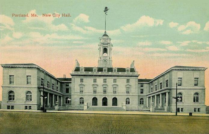
Portland City Hall
Monument and historic site · National Register of Historic Places · 2.4 mi
Government building in Maine, USA
389 Congress Street, Portland

Portland High School
Monument and historic site · National Register of Historic Places · 2.3 mi
High school in Portland, Cumberland County, Maine
284 Cumberland Avenue, Portland


Victoria Mansion
Monument and historic site · National Register of Historic Places · 1.9 mi
Historic house in Portland (Maine), United States
109 Danforth Street, Portland

68 High Street
Monument and historic site · National Register of Historic Places · 1.9 mi
Apartment building and former hospital in Portland, Maine, USA


A.B. Butler House
Monument and historic site · National Register of Historic Places · 1.4 mi
Historic house in Portland, Maine, United States
99 more on the map.
Parks, trails and playgrounds77


Fitzpatrick Stadium
Sports field and stadium · 1.9 mi
140 Deering Avenue, Portland
Hadlock Field
Sports field and stadium · 1.8 mi
271 Park Avenue, Portland

William B. Troubh Ice Arena
Sports field and stadium · 1.8 mi
225 Park Avenue, Portland
South Portland Skatepark
Park · 1.0 mi
25 Nelson Road, South Portland
sunrise-sunset
Valley Street Community Garden
Park · 1.3 mi
Built in 1995, Valley Street is the oldest community garden in Portland. The garden is located down the hill from the Western Promenade...

65 more on the map.
Restaurants and cafes259

Saeng Thai House
Restaurant · Thai · 1.6 mi
Family-run Thai restaurant
921 Congress Street, Portland
Mo, We-Su 11:00-21:30

Another Round
Cafe · Coffee Shop, Pastry · 2.1 mi
Board game bar and cafe.
549 Congress Street, Portland
Su-Tu,Th 08:00-21:00; Fr,Sa 08:00-23:00
Aroma Joe's
Cafe · Coffee Shop · 1.2 mi
633 Main Street, South Portland
Mo-Sa 04:30-22:00, Su 05:00-21:00

Cheese Louise
Restaurant · Grilled Cheese · 2.4 mi
363 Fore Street, Portland
Su-Th 11:00-21:00; Fr,Sa 11:00-13:00
Coppersmith Tavern and Table
Restaurant · Alcohol, Wine · 1.2 mi
671 Main Street, South Portland
Mo-Su 12:00-21:00
El Rayo Taqueria
Restaurant · Mexican, Burrito, Nachos, Tacos · 2.2 mi
26 Free Street, Portland
Mo-Sa 11:00-21:00; Su 11:00-19:30
Empire Chinese Kitchen
Restaurant · Chinese · 2.0 mi
575 Congress Street, Portland
Su-Mo 11:30-20:30; We-Th 11:30-20:30; Fr-Sa 11:30-20:45; Tu off
247 more on the map.
History
South Portland was first colonized in 1630, and it grew to become a small residential community with many farms. The village was raided by natives in Father Rale's War (1724). In 1858, the City of Portland purchased land near the Fore River for the Forest City Cemetery. On March 15, 1895, it was incorporated as a town after it broke away from Cape Elizabeth, based on a disagreement on a future source of public drinking water. Three years later South Portland became a city, destined to receive its drinking water, like Portland, from Sebago Lake, while Cape Elizabeth used wells or other local sources.
On South Portland's waterfront is Fort Preble, which is a military fort established in 1808 to protect Portland Harbor. It was in operation during several American conflicts, including the United States Civil War, World War I, and World War II. Near Fort Preble is Spring Point Ledge Light, which was constructed by the federal government in 1897 to mark a dangerous rock ledge.
In December 1844, Portland resident Ellen G. White, who became a founder of the Seventh-day Adventist church, is said to have experienced her first vision during a prayer meeting at the home of Mrs. Haines at 60 Ocean Street, which later became the Griffin Club. The building was torn down in 2018.
From the History section of South Portland, Maine on Wikipedia, under CC BY-SA 4.0.
Where to stay34
Holiday Inn Express & Suites South Portland
Motel and hotel · 2.6 mi
303 Sable Oaks Drive, South Portland
Churches and places of worship42
Shopping56
Gas and EV charging15
Schools, colleges and libraries67
Dr. Waldo T. Skillin Elementary School
School · 1.0 mi
180 Wescott Road, South Portland
Healthcare17
MaineHealth Comprehensive Addiction Medicine
Clinic and pharmacy · 2.2 mi
576 Saint John Street, Portland
Map of South Portland
250 places. The map loads OpenStreetMap tiles when you open it.
Climate by month
Monthly table
| Month | High | Low | Rain | Snow |
|---|---|---|---|---|
| Jan | 32°F | 16°F | 3.5 in | 18.6 in |
| Feb | 35°F | 17°F | 3.5 in | 16.6 in |
| Mar | 42°F | 26°F | 4.1 in | 13.6 in |
| Apr | 54°F | 35°F | 4.4 in | 2.8 in |
| May | 64°F | 46°F | 3.7 in | 0.0 in |
| Jun | 74°F | 55°F | 4.2 in | 0.0 in |
| Jul | 80°F | 61°F | 3.4 in | 0.0 in |
| Aug | 79°F | 60°F | 3.6 in | 0.0 in |
| Sep | 71°F | 52°F | 3.8 in | 0.0 in |
| Oct | 60°F | 41°F | 5.2 in | 0.2 in |
| Nov | 48°F | 32°F | 4.2 in | 2.3 in |
| Dec | 38°F | 22°F | 4.5 in | 14.6 in |
U.S. Climate Normals 1991-2020 for Portland Intl Jetport Hcn 72606 (1 mi away), NOAA NCEI.
People and cost of living
American Community Survey 5-year estimates, 2020-2024, U.S. Census Bureau. Estimates have margins of error, larger for small towns.
Disaster history
Cumberland County has had 21 federal disaster declarations since 2000, most often for severe storms.
- 2024-05-24: Severe Winter Storm (Winter Storm)
- 2024-03-20: Severe Storms And Flooding (Severe Storm)
- 2023-09-14: Hurricane Lee (Hurricane)
- 2020-04-04: Covid-19 Pandemic (Biological)
- 2020-03-13: Covid-19 (Biological)
- 2018-01-02: Severe Storm And Flooding (Severe Storm)
OpenFEMA disaster declarations summaries.
Getting there and nearby towns
Portland International Jetport (PWM) is the nearest airport with scheduled flights listed in OpenStreetMap, 2 miles away.
- Oak Hill 4 mi southwest, about 6 min by car
- Portland 5 mi east, about 8 min by car
- Westbrook 6 mi northwest, about 10 min by car
- Saco 10 mi southwest, about 16 min by car
- Biddeford 14 mi south, about 23 min by car
- Brunswick 25 mi northeast, about 40 min by car
- Sanford 28 mi southwest, about 44 min by car
- Auburn 31 mi north, about 50 min by car
- Lewiston 32 mi north, about 52 min by car
- Augusta 56 mi northeast, about 1 h 30 min by car
Drive times are estimates from straight-line distance, not routes.
Local news
Headlines from INDB, the NEMICO news database.
Reviews, tips and questions
Loading what members have shared...
Sources and licences
- NCES EDGE (Public domain): public schools
- NOAA NCEI U.S. Climate Normals 1991-2020 (Public domain): climate by month
- OpenFEMA (Public domain): disaster declarations
- OpenStreetMap contributors (ODbL 1.0): places, airports, map data
- U.S. Census Bureau (Public domain): population, income, housing, education, commute
- Wikidata (CC0 1.0): elevation, founding date, time zone, website, landmarks and historic places
- Wikimedia Commons (see each image): photos
- Wikipedia (CC BY-SA 4.0): overview and history text
Photo credits
- South Portland Marina, Peter Dutton from Forest Hills, Queens, USA, CC BY 2.0
- Calvary Cemetery, South Portland, Maine - 50728560977, Spirits Alive at the Eastern Cemetery, CC BY 2.0
- Calvary Cemetery, South Portland, Maine - 50728464761, Spirits Alive at the Eastern Cemetery, CC BY 2.0
- Calvary Cemetery, South Portland, Maine - 50727737643, Spirits Alive at the Eastern Cemetery, CC BY 2.0
- Calvary Cemetery, South Portland, Maine, Spirits Alive at the Eastern Cemetery, CC BY 2.0
- Calvary Cemetery, South Portland, Maine - 50728560772, Spirits Alive at the Eastern Cemetery, CC BY 2.0
- Calvary Cemetery, South Portland, Maine - 50728561232, Spirits Alive at the Eastern Cemetery, CC BY 2.0
- Calvary Cemetery, South Portland, Maine - 50728561477, Spirits Alive at the Eastern Cemetery, CC BY 2.0
- Calvary Cemetery, South Portland, Maine - 50727736663, Spirits Alive at the Eastern Cemetery, CC BY 2.0
- Victoria Mansion, Portland, Maine USA, Staib at English Wikipedia, CC BY-SA 3.0
- The Portland City Hall (in 1910) — Portland, Maine., Unknown author Unknown author, Public domain
- Cathedral of the Immaculate Conception Portland ME 2012, Richard Diekema, CC BY-SA 3.0
- LincolnParkMaine, Thomas.macmillan, Public domain
- Mechanics' Hall in Portland, Jack Boucher, Public domain
- Portland High School 2, BMRR, CC BY-SA 3.0
- 505 Fore Street, Portland ME, John Phelan, CC BY-SA 3.0
- Portland old harbour 08.07.2012 12-52-09, Dirk Ingo Franke, CC BY 3.0
- Spurwink Church, Cape Elizabeth, Maine, Rich Brooks from Scarborough, ME, CC BY 2.0
- PortlandME JBBrownBlock 2, User:Magicpiano, CC BY-SA 4.0
- PortlandME StLawrenceArtsCenter 1, User:Magicpiano, CC BY-SA 4.0
- 5th Maine Regiment Museum, Caitlin Regan from Jackson Heights, NY, USA, CC BY 2.0
- SAM 1258, Namiba, CC BY 3.0
- Marine Hospital - Portland, Maine, Farragutful, CC BY-SA 4.0
- 261 Western Promenade, Portland ME, John Phelan, CC BY-SA 3.0
- 68HighStreet, Namiba, CC BY-SA 3.0
- Charles Q. Clapp House, Jack Boucher, Public domain
- John B. Russwurm House, Farragutful, CC BY-SA 4.0
- Maine Eye and Ear Infirmary, Portland ME, John Phelan, CC BY-SA 3.0
- Portland City Hospital - Loring House Apartments 01, Farragutful, CC BY-SA 4.0
- DeeringOaksDeeringAvenue, Unknown author, Public domain
- HamblenBlock, Namiba, CC BY-SA 3.0
- How Houses - 23 Danforth St, Farragutful, CC BY-SA 4.0
- Hay Building, Portland, Maine, Kenneth C. Zirkel, CC BY-SA 4.0
- HarrisonBrownHouse, Namiba, CC BY-SA 3.0
- 30-32 Deering Street, Portland ME, John Phelan, CC BY-SA 3.0
- DowHouse, Thomas.macmillan, Public domain
- PortlandME TateHouse 02, User:Magicpiano, CC BY-SA 4.0
- DeeringStreetHistoricDistrict, TM, CC BY 3.0
- Forest City Cemetery Walk - 51316957902, Spirits Alive at the Eastern Cemetery, CC BY-SA 2.0
- Forest City Cemetery Walk - 51316957832, Spirits Alive at the Eastern Cemetery, CC BY-SA 2.0


Page built October 30, 2026. Spotted a mistake? Tell us or suggest a place.