


South River, New Jersey
South River is a borough of 16,124 people in Middlesex County, New Jersey.
Why visit South River
Townapedia lists 8 museums and landmarks, 16 parks and trails, 80 places to eat, 2 places to stay and 3 attractions in and around town.
Highlights include AMC Theaters, Basilone Memorial Bridge, Edward S. Kearney House and Milltown India Rubber Company.
July is the warmest month, with average highs of 86°F; January lows average 23°F, and about 29 inches of snow fall in a normal year.
Weather in South River
Forecast from the National Weather Service. Full forecast
About South River
South River is a borough in Middlesex County, in the U.S. state of New Jersey. As of the 2020 United States census, the borough's population was 16,118, an increase of 110 (+0.7%) from the 2010 census count of 16,008, which in turn reflected an increase of 686 (+4.5%) from the 15,322 counted in the 2000 census.
From the Wikipedia article South River, New Jersey (this version), under CC BY-SA 4.0.
Things to do3

AMC Theaters
Cinema and theater · 1.6 mi
755 State Route 18, East Brunswick
Mo-Sa 10:00-20:00; Su 12:00-18:00

Basilone Memorial Bridge
Bridge · 3.1 mi
Bridge in Middlesex County, New Jersey
Museums and landmarks8

Edward S. Kearney House
Monument and historic site · National Register of Historic Places · 3.0 mi
Historic house in Middlesex County, New Jersey
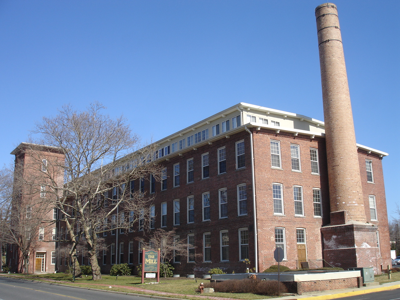
Milltown India Rubber Company
Monument and historic site · National Register of Historic Places · 3.0 mi
Historic building in Milltown, New Jersey

Sayre & Fisher Reading Room
Monument and historic site · National Register of Historic Places · 2.2 mi
Library

Thomas I. Agnew House
Monument and historic site · National Register of Historic Places · 3.5 mi
Historic house in New Brunswick, New Jersey

Sayreville 1909 Town Hall
Monument and historic site · 1.5 mi
165 Main Street, Sayreville
Parks, trails and playgrounds16





4 more on the map.
Restaurants and cafes80

Lala's BBQ
Restaurant · Argentinian, Barbecue · 0.8 mi
Authentic Argentinian Charcoal Grill
20 Jernee Mill Road, Sayreville
Tu-Th 10:00-21:00; Fr-Sa 11:00-22:00; Su 11:00-21:00
Angelo's Pizza & Restaurant
Restaurant · Pizza · 1.4 mi
80 Main Street, Sayreville
Mo-Sa 11:00-21:00; Su 01:00-21:00
Bonefish Grill
Restaurant · Seafood · 1.3 mi
335 NJ 18 South, East Brunswick
Mo-Th 11:00-22:00; Fr-Sa 11:00-23:00; Su 11:00-21:00

Brick House Bar & Grill
Bar and pub · American, Burger, Fish, Pasta, Polish, Sandwich · 1.7 mi
287 Washington Road, Sayreville
Mo-Su 12:00-02:00
Camillo's Restaraunt & Pizza
Restaurant · Italian · 1.0 mi
31 MacArthur Avenue, Sayreville
Su-Th 11:00-22:00; Fr-Sa 11:00-23:00
Carrabba's Italian Grill
Restaurant · Italian · 1.3 mi
335 NJ 18 Souh, East Brunswick
Mo-Th 11:00-22:00; Fr-Sa 11:00-23:00; Su 11:00-21:00
Colonial Diner
Restaurant · American, Pasta · 0.9 mi
560 NJ Route 18, East Brunswick
Su-Th 08:00-21:00; Fr-Sa 08:00-22:00

Denny's
Diner · American · 1.4 mi
752 State Route 18, East Brunswick
Mo-We 07:00-22:00; Th-Su 07:00-23:00
East Hana
Restaurant · Japanese · 1.2 mi
300 NJ 18 North, East Brunswick
Mo-Th 11:00-15:00,16:00-21:30; Fr-Sa 11:00-15:00, 16:00-22:00; Su...
68 more on the map.
History
South River was originally part of East Brunswick Township. Originally referred to as Washington, the community eventually split away, as did Spotswood and Milltown.
From 1683 to 1720, the area was commonly referred to as South River Landing. In 1720, the name Willettstown was adopted after settler Samuel Willett. In 1784, the name was changed to Washington and the area was variously referred to as Washington Village, Washington Woods, and Little Washington. The name was considered at the suggestion of Abraham Barkelew, one of the original settlers in the town. In 1870, the name was changed to South River and on February 28, 1898, South River officially became a borough.
From the History section of South River, New Jersey on Wikipedia, under CC BY-SA 4.0.
Where to stay2
Churches and places of worship27
Saint Mary of Ostrabrama Roman Catholic Church
Church · Roman Catholic
30 Jackson Street, South River
Old School Baptist Church and Cemetery
Church · National Register of Historic Places · 0.4 mi
Our Lady of Victories
Church · Roman Catholic · 1.3 mi
42 Main Street, Sayreville
Shopping26
Gas and EV charging10
Schools, colleges and libraries58
American Institute of Alternative Medicine
School · 0.9 mi
646 NJ Route 18, East Brunswick
Benjamin Franklin Elementary School
School · 4.1 mi
2485 Woodbridge Avenue, Edison
Healthcare7
Map of South River
237 places. The map loads OpenStreetMap tiles when you open it.
Climate by month
Monthly table
| Month | High | Low | Rain | Snow |
|---|---|---|---|---|
| Jan | 40°F | 23°F | 3.7 in | 8.3 in |
| Feb | 43°F | 24°F | 3.0 in | 9.3 in |
| Mar | 51°F | 31°F | 4.4 in | 5.2 in |
| Apr | 62°F | 41°F | 3.9 in | 0.6 in |
| May | 72°F | 51°F | 4.0 in | 0.0 in |
| Jun | 81°F | 60°F | 4.8 in | 0.0 in |
| Jul | 86°F | 66°F | 4.8 in | 0.0 in |
| Aug | 85°F | 64°F | 4.7 in | 0.0 in |
| Sep | 78°F | 56°F | 4.2 in | 0.0 in |
| Oct | 66°F | 44°F | 4.1 in | 0.2 in |
| Nov | 56°F | 35°F | 3.4 in | 0.5 in |
| Dec | 45°F | 28°F | 4.5 in | 4.9 in |
U.S. Climate Normals 1991-2020 for New Brunswick 3 Se Hcn (3 mi away), NOAA NCEI.
People and cost of living
American Community Survey 5-year estimates, 2020-2024, U.S. Census Bureau. Estimates have margins of error, larger for small towns.
Disaster history
Middlesex County has had 17 federal disaster declarations since 2000, most often for hurricanes.
- 2021-09-05: Remnants Of Hurricane Ida (Hurricane)
- 2021-09-02: Remnants Of Hurricane Ida (Hurricane)
- 2020-03-25: Covid-19 Pandemic (Biological)
- 2020-03-13: Covid-19 (Biological)
- 2016-03-14: Severe Winter Storm And Snowstorm (Severe Storm)
- 2012-10-30: Hurricane Sandy (Hurricane)
OpenFEMA disaster declarations summaries.
Getting there and nearby towns
Central Jersey Regional Airport (JVI) is the nearest airport with scheduled flights listed in OpenStreetMap, 13 miles away.
- Sayreville 3 mi northeast, about 5 min by car
- Old Bridge 4 mi southeast, about 7 min by car
- New Brunswick 4 mi northwest, about 7 min by car
- Highland Park 5 mi northwest, about 7 min by car
- East Franklin 6 mi northwest, about 9 min by car
- Metuchen 7 mi north, about 11 min by car
- Fords 7 mi northeast, about 11 min by car
- Perth Amboy 8 mi northeast, about 12 min by car
- Franklin Park 9 mi west, about 14 min by car
- Robertsville 9 mi southeast, about 14 min by car
Drive times are estimates from straight-line distance, not routes.
Local news
Headlines from INDB, the NEMICO news database.
Reviews, tips and questions
Loading what members have shared...
Sources and licences
- NCES EDGE (Public domain): public schools
- NOAA NCEI U.S. Climate Normals 1991-2020 (Public domain): climate by month
- OpenFEMA (Public domain): disaster declarations
- OpenStreetMap contributors (ODbL 1.0): places, airports, map data
- U.S. Census Bureau (Public domain): population, income, housing, education, commute
- Wikidata (CC0 1.0): elevation, founding date, time zone, website, landmarks and historic places
- Wikimedia Commons (see each image): photos
- Wikipedia (CC BY-SA 4.0): overview and history text
Photo credits
- SouthRiverNJ1936, Carl Mydans, Public domain
- South River, NJ Fire Department, May 2025, Mr. Matté (if there is an issue with this image, contact me using this image's Commons talk page , my Commons user talk page , or my English Wikipedia user talk page ; I'll know about it a lot faster), CC BY-SA 4.0
- Middlesex CR 677 nb, South River, NJ (3), Mr. Matté (if there is an issue with this image, contact me using this image's Commons talk page , my Commons user talk page , or my English Wikipedia user talk page ; I'll know about it a lot faster), CC BY-SA 4.0
- South River, NJ Municipal Building, May 2025, Mr. Matté (if there is an issue with this image, contact me using this image's Commons talk page , my Commons user talk page , or my English Wikipedia user talk page ; I'll know about it a lot faster), CC BY-SA 4.0
- CR 535 sb, South River, NJ, July 2026, Mr. Matté (if there is an issue with this image, contact me using this image's Commons talk page , my Commons user talk page , or my English Wikipedia user talk page ; I'll know about it a lot faster), CC BY-SA 4.0
- 2018-05-18 11 48 00 View south along Middlesex County Route 535 (Main Street) at Middlesex County Route 677 (Ferry Street) in South River, Middlesex County, New Jersey, Famartin, CC BY-SA 4.0
- Middlesex CR 677 nb, South River, NJ (4), Mr. Matté (if there is an issue with this image, contact me using this image's Commons talk page , my Commons user talk page , or my English Wikipedia user talk page ; I'll know about it a lot faster), CC BY-SA 4.0
- Middlesex CR 677 nb, South River, NJ (2), Mr. Matté (if there is an issue with this image, contact me using this image's Commons talk page , my Commons user talk page , or my English Wikipedia user talk page ; I'll know about it a lot faster), CC BY-SA 4.0
- 2018-05-18 11 16 19 View north along Middlesex County Route 535 (Main Street) at Middlesex County Route 527 (Old Bridge Turnpike) in South River, Middlesex County, New Jersey, Famartin, CC BY-SA 4.0
- Holy Trinity Episcopal Church, South River, NJ, May 2025, Mr. Matté (if there is an issue with this image, contact me using this image's Commons talk page , my Commons user talk page , or my English Wikipedia user talk page ; I'll know about it a lot faster), CC BY-SA 4.0
- 2018-05-21 13 49 15 View north along Middlesex County Route 527 (Old Bridge Turnpike) at Arthur Street on the border of South River and East Brunswick Township in Middlesex County, New Jersey, Famartin, CC BY-SA 4.0
- Middlesex CR 677 nb, South River, NJ (5), Mr. Matté (if there is an issue with this image, contact me using this image's Commons talk page , my Commons user talk page , or my English Wikipedia user talk page ; I'll know about it a lot faster), CC BY-SA 4.0
- Middlesex CR 677 nb, South River, NJ (1), Mr. Matté (if there is an issue with this image, contact me using this image's Commons talk page , my Commons user talk page , or my English Wikipedia user talk page ; I'll know about it a lot faster), CC BY-SA 4.0
- OldSchoolBaptistChurchSouthRiver, KForce, CC BY-SA 3.0
- MilltownIndiaRubberCo, KForce, CC BY-SA 3.0
- Thomas I. Agnew House, New Brunswick, NJ, Zeete, CC BY-SA 3.0
- Edward S. Kearney House front view, Gould363, CC BY-SA 3.0
- St. Mary South River, Ben McLaughlin, CC BY-SA 3.0
- SayreandFisherReadingRoom, KForce, CC BY-SA 3.0
- Limonite (40945048583), Pacific Museum of Earth from Canada, CC BY-SA 2.0
- A Corner Of Main Street, Jason Knauer, CC BY 3.0
- 2018-05-18 11 52 06 View south along Middlesex County Route 535 (Cranbury Road) at Middlesex County Route 527 (Old Bridge Turnpike) in East Brunswick Township, Middlesex County, New Jersey, Famartin, CC BY-SA 4.0
- Corner Store Apartment, Jason Knauer, CC BY 3.0
- 2021-07-30 14 15 17 View along the ramp connecting northbound New Jersey State Route 18 to Middlesex County Route 535 (Cranbury Road) in East Brunswick Township, Middlesex County, New Jersey, Famartin, CC BY-SA 4.0
- 2018-05-18 11 23 59 View north along Middlesex County Route 535 (Washington Road) at Middlesex County Route 675 (Jernee Mill Road) and MacArthur Avenue in Sayreville, Middlesex County, New Jersey, Famartin, CC BY-SA 4.0
- 2021-07-30 14 22 36 View north along New Jersey State Route 18 from the overpass for Middlesex County Route 606 (Milltown Road) in East Brunswick Township, Middlesex County, New Jersey, Famartin, CC BY-SA 4.0
- 2021-07-30 14 21 34 View south along New Jersey State Route 18 from the overpass for Middlesex County Route 606 (Milltown Road) in East Brunswick Township, Middlesex County, New Jersey, Famartin, CC BY-SA 4.0
- 2021-07-30 14 13 04 View north along New Jersey State Route 18 from the overpass for Middlesex County Route 535 (Cranbury Road) in East Brunswick Township, Middlesex County, New Jersey, Famartin, CC BY-SA 4.0
- 2021-07-30 14 10 03 View south along New Jersey State Route 18 from the overpass for Middlesex County Route 535 (Cranbury Road) in East Brunswick Township, Middlesex County, New Jersey, Famartin, CC BY-SA 4.0
- 2020-10-09 15 44 14 View north along Middlesex County Route 535 (Cranbury Road) at the exit for Middlesex County Route 535 SOUTH (Cranbury) in East Brunswick Township, Middlesex County, New Jersey, Famartin, CC BY-SA 4.0
- Toys R Us East Brunswick, NJ (28498522966), Mike Kalasnik from Unionville, CT, USA, CC BY-SA 2.0
- 2020-10-09 15 39 25 View north along Middlesex County Route 535 (Cranbury Road) at Middlesex County Route 613 (Summerhill Road) in East Brunswick Township, Middlesex County, New Jersey, Famartin, CC BY-SA 4.0
- Smashburger in East Brunswick, NJ, Tyler de Noche, CC BY-SA 4.0
- Playa Bowl East Brunswick 1, SeichanGant, CC BY-SA 4.0
- Playa Bowl East Brunswick 3, SeichanGant, CC BY-SA 4.0
- Playa Bowl East Brunswick 2, SeichanGant, CC BY-SA 4.0
- Playa Bowl East Brunswick 4, SeichanGant, CC BY-SA 4.0
- Save Ferris2 8-19-2023, Constantino14, CC BY-SA 4.0
- Golden East Chinese, SeichanGant, CC BY-SA 4.0
- Kpot Interior 2, SeichanGant, CC BY-SA 4.0


Page built October 30, 2026. Spotted a mistake? Tell us or suggest a place.