


Perth Amboy, New Jersey
Perth Amboy is a city of 55,855 people in Middlesex County, New Jersey, founded in 1683.
Why visit Perth Amboy
Townapedia lists 24 museums and landmarks, 31 parks and trails, 82 places to eat, 4 places to stay and 8 attractions in and around town.
Highlights include Driscoll Bridge, Edison Bridge, The Conference House and Proprietary House.
July is the warmest month, with average highs of 86°F; January lows average 23°F, and about 29 inches of snow fall in a normal year.
Weather in Perth Amboy
Forecast from the National Weather Service. Full forecast
About Perth Amboy
Perth Amboy is a historic waterfront city in northeastern Middlesex County, in the U.S. state of New Jersey, within the New York metropolitan area. As of the 2020 census, the city's population was 55,436. Perth Amboy is known as the "City by the Bay", referring to its location adjoining Raritan Bay.
From the Wikipedia article Perth Amboy, New Jersey (this version), under CC BY-SA 4.0.
Things to do8

Driscoll Bridge
Bridge · 1.7 mi
Toll bridge in New Jersey carrying the Garden State Parkway
Outerbridge Crossing
Bridge · 1.3 mi
Bridge between New Jersey and New York

Princes Bay Light
Lighthouse · 3.2 mi
Lighthouse in New York, United States
Raritan Bay Drawbridge
Bridge · 1.7 mi
Bridge in United States of America

Stephen J. Capestro Theatre
Cinema and theater · 3.9 mi
Outdoor theater in Edison, New Jersey
Museums and landmarks24


Proprietary House
Museum · National Register of Historic Places · 1.2 mi
Historic building in Perth Amboy, New Jersey
149 Kearny Avenue, Perth Amboy

5910 Amboy Road
Monument and historic site · National Register of Historic Places · 3.5 mi
House in Staten Island, New York City
Barron Library
Monument and historic site · National Register of Historic Places · 2.8 mi
Historic building in Woodbridge, New Jersey
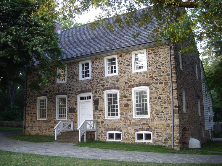
Conference House
Monument and historic site · National Register of Historic Places · 1.5 mi
Staten Island, New York location listed on National Register of Historic Places
Great Beds Light
Lighthouse · National Register of Historic Places · 2.5 mi
Lighthouse in New Jersey, United States
Kearny Cottage
Monument and historic site · National Register of Historic Places · 1.0 mi
Historic house in New Jersey, United States
Kreischer House
Monument and historic site · National Register of Historic Places · 1.9 mi
NY location listed on National Register of Historic Places


Perth Amboy
Monument and historic site · National Register of Historic Places · 0.8 mi
NJ Transit railway station
Perth Amboy City Hall and Surveyor General's Office
Monument and historic site · National Register of Historic Places · 1.0 mi
Historic buildings in Perth Amboy, New Jersey
Perth Amboy Ferry Slip
Monument and historic site · National Register of Historic Places · 1.0 mi
Seguine Mansion
Monument and historic site · National Register of Historic Places · 3.9 mi
Mansion in Staten Island, New York City
12 more on the map.
Parks, trails and playgrounds31

Clay Pit Ponds State Park Preserve
Park · 2.2 mi
State park in Staten Island, New York
Conference House Park
Park · 2.0 mi
Park in the United States of America


19 more on the map.
Restaurants and cafes82

Aunt Butchie's of Brooklyn
Restaurant · Italian · 1.7 mi
4864 Arthur Kill Road, Staten Island
Mo-We,Su 11:00-21:00; Th-Sa 11:00-22:00

Beans & Leaves
Cafe · Coffee Shop · 1.7 mi
4916 Arthur Kill Road, Staten Island
Mo-Fr 06:30-16:00; Sa-Su 08:00-15:00
Flores Brunch
Restaurant · Brunch · 1.9 mi
4553 Arthur Kill Road, Staten Island
Mo-Th 08:00-22:00; Fr-Su 08:00-23:00
Laila
Restaurant · Mediterranean · 1.9 mi
45 Page Avenue, Staten Island
Mo off; Tu-Th 12:00-22:00; Fr-Sa 12:00-23:00; Su 12:00-21:00
Loon Chuan
Restaurant · Chinese · 1.9 mi
85 Page Avenue, Staten Island
Mo-Sa 12:00-21:00; Su 13:00-21:00
Nucci's South Italian Restaurant
Restaurant · Italian · 1.7 mi
4842 Arthur Kill Road, Staten Island
Mo-Th 11:00-22:00; Fr-Sa 11:00-23:00; Su 11:00-21:00
Palermo Pizzeria & Restaurant
Restaurant · Pizza · 1.9 mi
95 Page Avenue, Staten Island
Mo-Th,Su 11:00-22:00; Fr-Sa 11:00-23:00
Quintana's Mexican Restaurant & Bakery
Restaurant · Mexican, Tex-Mex · 0.7 mi
334 Smith Street, Perth Amboy
Mo off; Tu-Sa 10:00-22:00; Su 10:00-20:00
Rosevelt's Deli
Restaurant · Sandwich · 2.1 mi
684 King Georges Post Road, Woodbridge Township
Mo-Fr 06:00-22:00; Sa 07:00-22:00; Su 08:00-15:00
Towne Deli & Pizzeria
Restaurant · Pizza · 1.3 mi
5373 Arthur Kill Road
Mo-Sa 07:00-23:00; Su 08:00-23:00
Tutto Apposto
Restaurant · Italian · 2.0 mi
31 Page Avenue, Staten Island
Mo off; Tu-Th 11:00-22:00; Fr,Sa 11:00-23:00; Su 11:00-20:00
70 more on the map.
Where to stay4
Churches and places of worship60
Simpson United Methodist Church
Church · Methodist · National Register of Historic Places · 0.8 mi
First Presbyterian Church
Church · National Register of Historic Places · 2.9 mi
St. Peter's Episcopal Church
Church · National Register of Historic Places · 1.2 mi
Trinity Episcopal Church
Church · National Register of Historic Places · 2.9 mi
Woodrow Methodist Church
Church · National Register of Historic Places · 4.0 mi
Saint Demetrios Greek Orthodox Church
Church · Greek Orthodox · 1.4 mi
41-47 Wisteria Street, Perth Amboy
Saint Peters Episcopal Church
Church · Episcopal · 1.2 mi
183 Rector Street, Perth Amboy
Shopping27
YCapellan Custom Balloons Gifts & More
Shop · 0.8 mi
261 Madison Avenue, Perth Amboy
Gas and EV charging14
Schools, colleges and libraries60
Perth Amboy Public Library
Library · National Register of Historic Places · 0.7 mi
196 Jefferson Street, Perth Amboy
Dr. Herbert N. Richardson 21st Century Elementary School
School · 0.6 mi
318 Stockton Street, Perth Amboy
Healthcare11
Map of Perth Amboy
250 places. The map loads OpenStreetMap tiles when you open it.
Climate by month
Monthly table
| Month | High | Low | Rain | Snow |
|---|---|---|---|---|
| Jan | 40°F | 23°F | 3.7 in | 8.3 in |
| Feb | 43°F | 24°F | 3.0 in | 9.3 in |
| Mar | 51°F | 31°F | 4.4 in | 5.2 in |
| Apr | 62°F | 41°F | 3.9 in | 0.6 in |
| May | 72°F | 51°F | 4.0 in | 0.0 in |
| Jun | 81°F | 60°F | 4.8 in | 0.0 in |
| Jul | 86°F | 66°F | 4.8 in | 0.0 in |
| Aug | 85°F | 64°F | 4.7 in | 0.0 in |
| Sep | 78°F | 56°F | 4.2 in | 0.0 in |
| Oct | 66°F | 44°F | 4.1 in | 0.2 in |
| Nov | 56°F | 35°F | 3.4 in | 0.5 in |
| Dec | 45°F | 28°F | 4.5 in | 4.9 in |
U.S. Climate Normals 1991-2020 for New Brunswick 3 Se Hcn (9 mi away), NOAA NCEI.
People and cost of living
American Community Survey 5-year estimates, 2020-2024, U.S. Census Bureau. Estimates have margins of error, larger for small towns.
Disaster history
Middlesex County has had 17 federal disaster declarations since 2000, most often for hurricanes.
- 2021-09-05: Remnants Of Hurricane Ida (Hurricane)
- 2021-09-02: Remnants Of Hurricane Ida (Hurricane)
- 2020-03-25: Covid-19 Pandemic (Biological)
- 2020-03-13: Covid-19 (Biological)
- 2016-03-14: Severe Winter Storm And Snowstorm (Severe Storm)
- 2012-10-30: Hurricane Sandy (Hurricane)
OpenFEMA disaster declarations summaries.
Getting there and nearby towns
Linden Airport (LDJ) is the nearest airport with scheduled flights listed in OpenStreetMap, 7 miles away.
- Fords 2 mi northwest, about 4 min by car
- Iselin 4 mi northwest, about 7 min by car
- Avenel 4 mi north, about 7 min by car
- Carteret 5 mi northeast, about 8 min by car
- Metuchen 5 mi west, about 8 min by car
- Colonia 5 mi northwest, about 8 min by car
- Linden 8 mi north, about 12 min by car
- Highland Park 8 mi west, about 13 min by car
- New Brunswick 9 mi west, about 15 min by car
- Old Bridge 9 mi south, about 15 min by car
Drive times are estimates from straight-line distance, not routes.
Local news
Headlines from INDB, the NEMICO news database.
Reviews, tips and questions
Loading what members have shared...
Sources and licences
- NCES EDGE (Public domain): public schools
- NOAA NCEI U.S. Climate Normals 1991-2020 (Public domain): climate by month
- OpenFEMA (Public domain): disaster declarations
- OpenStreetMap contributors (ODbL 1.0): places, airports, map data
- U.S. Census Bureau (Public domain): population, income, housing, education, commute
- Wikidata (CC0 1.0): elevation, founding date, time zone, website, landmarks and historic places
- Wikimedia Commons (see each image): photos
- Wikipedia (CC BY-SA 4.0): overview and history text
Photo credits
- CourtHousePoliceHQPerthAmboy, Rafaelgarcia, CC BY-SA 3.0
- 2025-09-15 16 13 25 Aerial view of western Perth Amboy and southern Woodbridge Township in Middlesex County, New Jersey from an aircraft heading for Newark Liberty International Airport, Famartin, CC BY-SA 4.0
- 2025-09-15 16 13 19 Aerial view of western Perth Amboy and southern Woodbridge Township in Middlesex County, New Jersey from an aircraft heading for Newark Liberty International Airport, Famartin, CC BY-SA 4.0
- Karl Mathiasen Mausoleum, Alpine Cemetery, Perth Amboy, NJ, Zeete, CC BY-SA 4.0
- Ellen Falvey Royle monument, Saint Mary's Cemetery, Perth Amboy, NJ, Zeete, CC BY-SA 4.0
- Saint Mary's Cemetery, Perth Amboy, NJ - area view, Zeete, CC BY-SA 4.0
- Alpine Cemetery, Perth Amboy, NJ - area view, Zeete, CC BY-SA 4.0
- Alling family monument, Alpine Cemetery, Perth Amboy, NJ, Zeete, CC BY-SA 4.0
- 2020-07-13 17 21 26 View north along New Jersey State Route 440 and Middlesex County Route 501 (Middlesex Freeway) at the exit for State Street-High Street-Perth Amboy in Perth Amboy, Middlesex..., Famartin, CC BY-SA 4.0
- Sofield family monument, Alpine Cemetery, Perth Amboy, NJ, Zeete, CC BY-SA 4.0
- 2021-08-24 13 58 10 View south along New Jersey State Route 440 and Middlesex County Route 501 (Middlesex Freeway) from the pedestrian overpass between Lawrence Street and Grove Street in Perth..., Famartin, CC BY-SA 4.0
- 2021-08-24 13 58 53 View north along New Jersey State Route 440 and Middlesex County Route 501 (Middlesex Freeway) from the pedestrian overpass between Lawrence Street and Grove Street in Perth..., Famartin, CC BY-SA 4.0
- 2020-07-14 10 31 12 View south along New Jersey State Route 440 and Middlesex County Route 501 (Middlesex Freeway) at the exit for New Jersey State Route 440 NORTH-New Jersey State Route 35..., Famartin, CC BY-SA 4.0
- Inger E. Madsen grave, Alpine Cemetery, Perth Amboy, NJ, Zeete, CC BY-SA 4.0
- Oluf Thulesen grave, Alpine Cemetery, Perth Amboy, NJ, Zeete, CC BY-SA 4.0
- 2020-07-14 10 33 09 View south along New Jersey State Route 440 and Middlesex County Route 501 (Middlesex Freeway) at the exit for New Jersey State Route 184 WEST-Garden State Parkway NORTH-New..., Famartin, CC BY-SA 4.0
- 2021-08-24 13 54 03 View north along New Jersey State Route 440 and Middlesex County Route 501 (Middlesex Freeway) from the overpass for Middlesex County Route 653 (Amboy Avenue) in Perth Amboy..., Famartin, CC BY-SA 4.0
- 2018-05-18 16 49 43 View north along New Jersey State Route 35 (Convery Boulevard) at Lawrie Street in Perth Amboy, Middlesex County, New Jersey, Famartin, CC BY-SA 4.0
- 2021-08-24 13 52 16 View south along New Jersey State Route 440 and Middlesex County Route 501 (Middlesex Freeway) from the overpass for Middlesex County Route 653 (Amboy Avenue) in Perth Amboy..., Famartin, CC BY-SA 4.0
- Perth Amboy P1010987mod, JYB Devot, CC BY-SA 4.0
- Perth Amboy Public Library, NJ - east elevation, 2025, Zeete, CC BY-SA 4.0
- Perth Amboy Public Library, NJ - 2025, Zeete, CC BY-SA 4.0
- 2018-05-18 15 52 55 View south along New Jersey State Route 35 (Convery Boulevard) at Harding Avenue in Perth Amboy, Middlesex County, New Jersey, Famartin, CC BY-SA 4.0
- 2018-09-23 11 37 16 View north along New Jersey State Route 440 and east along Middlesex County Route 501 (Middlesex Freeway) just northeast of the interchange with New Jersey Route 184 in Perth..., Famartin, CC BY-SA 4.0
- 2021-08-24 13 43 58 View north along New Jersey State Route 440 and Middlesex County Route 501 (Middlesex Freeway) from the overpass for New Jersey State Route 35 (Convery Boulevard) in Perth Amboy..., Famartin, CC BY-SA 4.0
- 2021-08-24 13 42 35 View south along New Jersey State Route 440 and Middlesex County Route 501 (Middlesex Freeway) from the overpass for New Jersey State Route 35 (Convery Boulevard) in Perth Amboy..., Famartin, CC BY-SA 4.0
- 2020-10-09 16 58 55 View east along Middlesex County Route 501 at the exit for Amboy Avenue in Perth Amboy, Middlesex County, New Jersey, Famartin, CC BY-SA 4.0
- 2020-10-11 17 36 34 View west along Middlesex County Route 501 at the exit for New Jersey State Route 35 SOUTH in Perth Amboy, Middlesex County, New Jersey, Famartin, CC BY-SA 4.0
- 2018-05-20 14 41 10 View south along New Jersey State Route 440 (Middlesex Freeway) just south of the interchange with New Jersey State Route 35 and New Jersey State Route 184 in Perth Amboy..., Famartin, CC BY-SA 4.0
- 2020-09-24 13 51 59 View east along New Jersey State Route 184 (Pfeiffer Boulevard) at Harding Avenue in Perth Amboy, Middlesex County, New Jersey, Famartin, CC BY-SA 4.0
- 2020-09-14 08 02 44 View south along New Jersey Route 35 (Convery Boulevard) at the exit for New Jersey State Route 440 (State Street, Staten Island) in Perth Amboy, Middlesex County, New Jersey, Famartin, CC BY-SA 4.0
- 2020-09-24 13 55 39 View west along New Jersey State Route 184 (Pfeiffer Boulevard) at New Jersey State Route 35 (Convery Boulevard) in Perth Amboy, Middlesex County, New Jersey, Famartin, CC BY-SA 4.0
- 2021-08-24 13 34 39 View south along New Jersey State Route 440 (Middlesex Freeway) from the overpass for New Jersey State Route 184 and Middlesex County Route 501 (Pfeiffer Boulevard) in Perth..., Famartin, CC BY-SA 4.0
- ProprietaryHousePerthAmboy, Rafaelgarcia, Public domain
- Perth Amboy Station - April 2015, Adam Moss, CC BY-SA 2.0
- First Presbyterian Church of Woodbridge, Perrycart, CC BY-SA 3.0
- South Pole SI jeh, Jim.henderson, Public domain
- Woodrow U Meth Ch Huguenot jeh, Jim.henderson, Public domain
- Trinity Episcopal Church, Woodbridge, NJ - south west view, Zeete, CC BY-SA 4.0
- Conference-house-staten-island, Dmadeo, CC BY-SA 3.0


Page built October 30, 2026. Spotted a mistake? Tell us or suggest a place.