

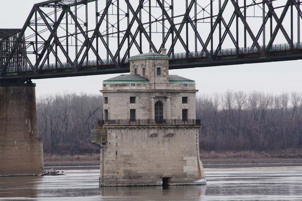


Spanish Lake, Missouri
Spanish Lake is a community of 17,873 people in St. Louis County, Missouri.
Why visit Spanish Lake
Townapedia lists 6 museums and landmarks, 11 parks and trails, 14 places to eat and 4 attractions in and around town.
Highlights include Bellefontaine Bridge, New Chain of Rocks Bridge, Chain of Rocks Bridge and Fort Belle Fontaine.
July is the warmest month, with average highs of 87°F; January lows average 22°F.
Weather in Spanish Lake
Forecast from the National Weather Service. Full forecast
About Spanish Lake
Spanish Lake is an unincorporated community and census-designated place (CDP) in Spanish Lake and St. Ferdinand townships, St. Louis County, Missouri, United States. The population was 18,413 at the 2020 census.
From the Wikipedia article Spanish Lake, Missouri (this version), under CC BY-SA 4.0.
Things to do4

Bellefontaine Bridge
Bridge · 4.1 mi
Railroad bridge over the Missouri River

New Chain of Rocks Bridge
Bridge · 2.5 mi
Bridge in United States of America


Saint Louis Zoo WildCare Park
Zoo and aquarium · 1.3 mi
Saint Louis Zoo WildCare Park is a world-class safari park and conservation center set to open in 2027 on 425 acres .
12385 Larimore Road, St. Louis
Museums and landmarks6
Chain of Rocks Bridge
Bridge · National Register of Historic Places · 2.6 mi
Footbridge

Fort Belle Fontaine
Monument and historic site · National Register of Historic Places · 2.7 mi
Lewis and Clark National historic Trail site in St. Louis County, Missouri, United States

Gen. Daniel Bissell House
Monument and historic site · National Register of Historic Places · 2.4 mi
Historic house in Bellefontaine Neighbors, Missouri

Wilson Larimore House
Monument and historic site · National Register of Historic Places · 1.0 mi
Historic site, former plantation
Parks, trails and playgrounds11


Chain of Rocks Park
Park · 2.3 mi
Park in Missouri, United States of America, United States of America
Colonel George H. Blasé Park
Park · 3.2 mi
Municipal park in St. Louis, Missouri


Fort Belle Fontaine County Park
Park · 2.6 mi
Public park in St. Louis County, Missouri, United States


Restaurants and cafes14

Pizza Hut
Restaurant · Pizza · 1.4 mi
11051 Bellefontaine Road, Spanish Lake
Su-Th 10:30-22:00; Fr,Sa 10:30-24:00

Down Home Elegance
Diner · American · 1.5 mi
10832 Bellefontaine Road, Bellefontaine Neighbors

Taco Bell
Fast food · Tex-Mex · 1.4 mi
6934 Parker Road, Florissant
Mo-We 08:00-01:00; Th 08:00-24:00; Fr-Su 08:00-01:00
KFC
Fast food · Chicken · 1.3 mi
11010 Sierra Vista Parkway, Spanish Lake
Mo-Th 10:30-21:00; Fr-Sa 10:30-22:00; Su 10:30-21:00
2 more on the map.
History
Spanish Lake, originally called Spanish Pond until the late nineteenth century, was named after the Spanish troops who stayed there while building a fortified post for Spain in 1768. Much of the area was once the property of James De St. Vrain, a brother of the last Spanish lieutenant governor of Upper Louisiana. It was in this district, near Spanish Pond, that an old log cabin, said to have been used as a government building by Lieutenant Governor De Lassus De St. Vrain, the last Spanish executive to rule this section, was erected.
Spanish Lake prospered in the nineteenth century, as a crossroads farming village came into being. The Bellefontaine Road area was settled largely after General Bissell relocated Fort Bellefontaine. Fort Bellefontaine was established in 1806 by Gen. James Wilkerson, governor of the territory of Louisiana. The fort served as one of the most important military posts west of the Mississippi River until the troops were removed to the Jefferson Barracks reservation in 1827. Traffic between St. Louis and the fort was busy; many officials had homes in both places, and visiting dignitaries usually went to both sites. The liveliest traffic was effected by the farmers riding back and forth to the city.
From the History section of Spanish Lake, Missouri on Wikipedia, under CC BY-SA 4.0.
Churches and places of worship24
Shopping2
Gas and EV charging5
Schools, colleges and libraries55
Healthcare2
Map of Spanish Lake
123 places. The map loads OpenStreetMap tiles when you open it.
Climate by month
Monthly table
| Month | High | Low | Rain |
|---|---|---|---|
| Jan | 39°F | 22°F | 2.5 in |
| Feb | 44°F | 25°F | 2.5 in |
| Mar | 54°F | 35°F | 3.5 in |
| Apr | 66°F | 45°F | 4.9 in |
| May | 75°F | 56°F | 5.5 in |
| Jun | 84°F | 66°F | 3.4 in |
| Jul | 87°F | 69°F | 4.0 in |
| Aug | 86°F | 67°F | 3.3 in |
| Sep | 80°F | 60°F | 3.4 in |
| Oct | 68°F | 48°F | 2.9 in |
| Nov | 54°F | 36°F | 3.4 in |
| Dec | 44°F | 27°F | 2.6 in |
U.S. Climate Normals 1991-2020 for Alton - Melvin Price L&D (6 mi away), NOAA NCEI.
People and cost of living
American Community Survey 5-year estimates, 2020-2024, U.S. Census Bureau. Estimates have margins of error, larger for small towns.
Disaster history
St. Louis County has had 23 federal disaster declarations since 2000, most often for severe storms.
- 2025-06-09: Severe Storms, Straight-Line Winds, Tornadoes, And Flooding (Severe Storm)
- 2025-05-21: Severe Storms, Straight-Line Winds, Tornadoes, And Wildfires (Severe Storm)
- 2022-08-08: Severe Storms And Flooding (Flood)
- 2020-03-26: Covid-19 Pandemic (Biological)
- 2020-03-13: Covid-19 (Biological)
- 2017-06-02: Severe Storms, Tornadoes, Straight-Line Winds And Flooding (Flood)
OpenFEMA disaster declarations summaries.
Getting there and nearby towns
St. Louis Lambert International Airport (STL) is the nearest airport with scheduled flights listed in OpenStreetMap, 9 miles away.
- Bellefontaine Neighbors 3 mi southwest, about 4 min by car
- Old Jamestown 5 mi northwest, about 8 min by car
- Ferguson 5 mi southwest, about 9 min by car
- Jennings 5 mi southwest, about 9 min by car
- Granite City 6 mi southeast, about 10 min by car
- Florissant 6 mi west, about 10 min by car
- Alton 9 mi north, about 14 min by car
- Wood River 9 mi northeast, about 14 min by car
- Hazelwood 10 mi west, about 16 min by car
- St. Louis 11 mi south, about 17 min by car
Drive times are estimates from straight-line distance, not routes.
Local news
Headlines from INDB, the NEMICO news database.
Reviews, tips and questions
Loading what members have shared...
Sources and licences
- NCES EDGE (Public domain): public schools
- NOAA NCEI U.S. Climate Normals 1991-2020 (Public domain): climate by month
- OpenFEMA (Public domain): disaster declarations
- OpenStreetMap contributors (ODbL 1.0): places, airports, map data
- U.S. Census Bureau (Public domain): population, income, housing, education, commute
- Wikidata (CC0 1.0): elevation, founding date, time zone, website, landmarks and historic places
- Wikimedia Commons (see each image): photos
- Wikipedia (CC BY-SA 4.0): overview and history text
Photo credits
- Fort Bellfontaine, Aakeene, CC BY-SA 4.0
- Water Intake CoRB, Rklawton at English Wikipedia, CC BY-SA 3.0
- Wilson Larimore House 1985, National Park Service, U.S. Department of the Interior, Public domain
- Cementland in 2015, Paul Sableman, CC BY 2.0
- Colonel George H. Blasé Park, Sesamehoneytart, CC BY-SA 4.0
- Belle Fontaine Staircase 50, Kbh3rd, CC BY 3.0
- Bellefontaine-bridge, Americasroof at English Wikipedia, CC BY-SA 2.5
- Chain of Rocks Bridges 1997, USGS, Public domain
- Lewis-bridge, The original uploader was Americasroof at English Wikipedia ., CC BY-SA 2.5
- Trinity Catholic High School in St. Louis County from side, DiamondRemley39, CC BY-SA 4.0
- ISS038-E-18643 - View of Earth, Earth Science and Remote Sensing Unit , Lyndon B. Johnson Space Center, Public domain
- ISS038-E-18642 - View of Earth, Earth Science and Remote Sensing Unit , Lyndon B. Johnson Space Center, Public domain
- ISS038-E-18645 - View of Earth, Earth Science and Remote Sensing Unit , Lyndon B. Johnson Space Center, Public domain
- ISS038-E-18644 - View of Earth, Earth Science and Remote Sensing Unit , Lyndon B. Johnson Space Center, Public domain
- ISS038-E-18647 - View of Earth, Earth Science and Remote Sensing Unit , Lyndon B. Johnson Space Center, Public domain
- ISS038-E-18646 - View of Earth, Earth Science and Remote Sensing Unit , Lyndon B. Johnson Space Center, Public domain
- Trinity Catholic High School in St. Louis County entrance, DiamondRemley39, CC BY-SA 4.0
- Trinity Catholic High School in St. Louis County from street, DiamondRemley39, CC BY-SA 4.0
- Wilson Larimore House, LittleT889, CC BY-SA 4.0
- 1522 Heading South, David Ackerman, CC BY 2.0
- Cisseps fulvicollis 167981491, Chrissy McClarren and Andy Reago, CC0
- The Archivist of the United States looks at burned records at NPRC, archivesnews, Public domain
- The Archivist of the United States and Preservation staff look at burned records at NPRC, archivesnews, Public domain
- New Chain of Rocks Bridge, Dave Herholz from St. Louis, USA, CC BY-SA 2.0
- American Golden Plover (13393439964), Andy Reago & Chrissy McClarren, CC BY 2.0
- BisselHouse, Chuck Morris, CC BY-SA 3.0
- Old water intake cribs of the Chain of Rocks Water Purification Plant, artistmac, CC BY-SA 2.0


Page built October 30, 2026. Spotted a mistake? Tell us or suggest a place.