


Sylvan Lake, Michigan
Sylvan Lake is a city of 1,705 people in Oakland County, Michigan, founded in 1824.
Why visit Sylvan Lake
Townapedia lists 25 museums and landmarks, 32 parks and trails, 40 places to eat and 1 place to stay in and around town.
Highlights include Apple Island, Casa del Rey Apartments, Baxter-Morgan Park and Beaudette Park.
July is the warmest month, with average highs of 82°F; January lows average 17°F, and about 36 inches of snow fall in a normal year.
Weather in Sylvan Lake
Forecast from the National Weather Service. Full forecast
About Sylvan Lake
Sylvan Lake is a city in Oakland County in the U.S. state of Michigan. A northern suburb of Detroit, Sylvan Lake is located roughly 26 miles (41.8 km) from downtown Detroit, and borders Pontiac to the east. As of the 2020 census, Sylvan Lake had a population of 1,723. With a land area of 0.51 square miles (1.32 km2), Sylvan Lake is the fourth-smallest city by land area in the state after Clarkston, Petersburg, and neighboring Keego Harbor.
From the Wikipedia article Sylvan Lake, Michigan (this version), under CC BY-SA 4.0.
Museums and landmarks25

Apple Island
Monument and historic site · National Register of Historic Places · 2.7 mi
Island in the United States of America

Casa del Rey Apartments
Monument and historic site · National Register of Historic Places · 1.6 mi
Multifamily residential in Pontiac, United States of America

Central School
Monument and historic site · National Register of Historic Places · 2.7 mi
School in Pontiac, Michigan, United States
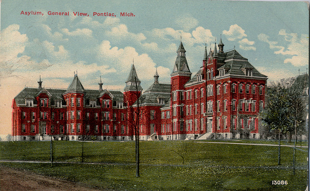
Clinton Valley Center
Monument and historic site · National Register of Historic Places · 2.1 mi
Psychiatric hospital located in Michigan

Eagle Theatre
Monument and historic site · National Register of Historic Places · 2.5 mi
Movie theater in Pontiac, Michigan, United States

Fairgrove Avenue Historic District
Monument and historic site · National Register of Historic Places · 2.8 mi
Historic residential district in Pontiac, Michigan, USA

Franklin Boulevard Historic District
Monument and historic site · National Register of Historic Places · 2.0 mi
Historic district in Pontiac, Michigan

Gillespie Street-Clinton River Bridge
Bridge · National Register of Historic Places · 1.9 mi
Road bridge in Pontiac, United States of America

Horatio N. Howard House
Monument and historic site · National Register of Historic Places · 2.9 mi
Pontiac, Michigan, listed on the NRHP in Oakland County

Michigan Military Academy
Monument and historic site · National Register of Historic Places · 2.0 mi
Defunct military prep school in Orchard Lake Village, Oakland County, Michigan USA

Myrick-Palmer House
Monument and historic site · National Register of Historic Places · 2.1 mi
House in Pontiac, United States of America


Oak Hill Cemetery
Monument and historic site · National Register of Historic Places · 3.0 mi
Cemetery in Pontiac, Michigan
13 more on the map.
Parks, trails and playgrounds32



20 more on the map.
Restaurants and cafes40


Ray’s Crispy Fish & Chicken
Restaurant · Seafood · 1.1 mi
143 South Telegraph Road, Pontiac
Mo-Sa 11:00-20:30

The Lodge
Restaurant · 0.7 mi
2812 Orchard Lake Road, Keego Harbor
Mo-Th 11:00-23:00; Fr-Sa 11:00-24:00; Su 11:00-23:00
Ellen's Bakery and Cafe
Cafe · 0.5 mi
Fresh baked bread and serving breakfast, lunch, and dinner
2495 Orchard Lake Road, Sylvan Lake
Gino's Pizzeria & Restaurant
Restaurant · Italian · 0.7 mi
1999 Cass Lake Road, Keego Harbor
Mo-Fr 15:00-21:00; Sa,Su 14:00-21:00
Happy's Pizza
Restaurant · Pizza · 0.8 mi
312 South Telegraph Road, Pontiac
Zara Shawarma Grill
Restaurant · Mediterranean · 0.8 mi
304 South Telegraph Road, Pontiac
28 more on the map.
Where to stay1

Cass Lake Hotel
Motel and hotel · 1.1 mi
120 South Telegraph Road, Waterford
Churches and places of worship9
St. Vincent DePaul Catholic Church, Convent, and School
Church · National Register of Historic Places · 2.6 mi
Lakes Area of Keego Harbor Church
Church · 0.8 mi
2091 Cass Lake Road, Keego Harbor
The Muslim Unity Center
Place of worship · 1.2 mi
1830 West Square Lake Road, Bloomfield Hills
Shopping4
Gas and EV charging9
Schools, colleges and libraries43
Arts And Technology Academy of Pontiac
School · 4.2 mi
888 Enterprise Dr, Pontiac
Healthcare5
Map of Sylvan Lake
168 places. The map loads OpenStreetMap tiles when you open it.
Climate by month
Monthly table
| Month | High | Low | Rain | Snow |
|---|---|---|---|---|
| Jan | 31°F | 17°F | 2.2 in | 12.1 in |
| Feb | 34°F | 18°F | 1.9 in | 9.0 in |
| Mar | 44°F | 26°F | 2.2 in | 4.1 in |
| Apr | 58°F | 36°F | 2.9 in | 0.9 in |
| May | 69°F | 49°F | 3.8 in | 0.0 in |
| Jun | 78°F | 59°F | 3.3 in | 0.0 in |
| Jul | 82°F | 63°F | 3.1 in | 0.0 in |
| Aug | 81°F | 62°F | 3.2 in | 0.0 in |
| Sep | 74°F | 54°F | 2.9 in | 0.0 in |
| Oct | 60°F | 42°F | 2.9 in | 0.1 in |
| Nov | 47°F | 32°F | 3.1 in | 1.7 in |
| Dec | 36°F | 24°F | 2.2 in | 8.1 in |
U.S. Climate Normals 1991-2020 for Pontiac Wwtp (4 mi away), NOAA NCEI.
People and cost of living
American Community Survey 5-year estimates, 2020-2024, U.S. Census Bureau. Estimates have margins of error, larger for small towns.
Disaster history
Oakland County has had 10 federal disaster declarations since 2000, most often for severe storms.
- 2024-02-08: Severe Storms, Tornadoes, And Flooding (Flood)
- 2021-07-15: Severe Storms, Flooding, And Tornadoes (Severe Storm)
- 2020-03-27: Covid-19 Pandemic (Biological)
- 2020-03-13: Covid-19 (Biological)
- 2014-09-25: Severe Storms And Flooding (Flood)
- 2005-09-07: Hurricane Katrina Evacuation (Hurricane)
OpenFEMA disaster declarations summaries.
Getting there and nearby towns
Oakland County International Airport (PTK) is the nearest airport with scheduled flights listed in OpenStreetMap, 6 miles away.
- Keego Harbor 1 mi southwest, about 1 min by car
- Pontiac 3 mi northeast, about 5 min by car
- Orchard Lake Village 3 mi southwest, about 4 min by car
- Auburn Hills 6 mi northeast, about 10 min by car
- Franklin 7 mi south, about 11 min by car
- Bingham Farms 7 mi south, about 12 min by car
- Birmingham 8 mi southeast, about 12 min by car
- Beverly Hills 8 mi southeast, about 13 min by car
- Farmington Hills 9 mi south, about 15 min by car
- Rochester Hills 9 mi east, about 15 min by car
Drive times are estimates from straight-line distance, not routes.
Local news
Headlines from INDB, the NEMICO news database.
Reviews, tips and questions
Loading what members have shared...
Sources and licences
- NCES EDGE (Public domain): public schools
- NOAA NCEI U.S. Climate Normals 1991-2020 (Public domain): climate by month
- OpenFEMA (Public domain): disaster declarations
- OpenStreetMap contributors (ODbL 1.0): places, airports, map data
- U.S. Census Bureau (Public domain): population, income, housing, education, commute
- Wikidata (CC0 1.0): elevation, founding date, time zone, website, landmarks and historic places
- Wikimedia Commons (see each image): photos
- Wikipedia (CC BY-SA 4.0): overview and history text
Photo credits
- Fairgrove Avenue Historic District Pontiac MI A, Andrew Jameson, CC BY-SA 3.0
- St Vincent DePaul Catholic Church Pontiac MI, Andrew Jameson, CC BY-SA 3.0
- Casa del Rey Apartments Pontiac MI, Andrew Jameson, CC BY-SA 3.0
- Wisner House Pontiac MI, Andrew Jameson, CC BY-SA 3.0
- Oak Hill Cemetery Pontiac MI A, Andrew Jameson, CC BY-SA 3.0
- Gillespie Street-Clinton River Bridge Pontiac MI, Andrew Jameson, CC BY-SA 3.0
- StMarysprepbuilding, Gsgeorge, Public domain
- Horatio N Howard House Pontiac MI, Andrew Jameson, CC BY-SA 3.0
- Central School Pontiac MI, Andrew Jameson, CC BY-SA 3.0
- Pontiac Asylum c 1912, Unknown author Unknown author, Public domain
- Eagle Theater Pontiac MI, Andrew Jameson, CC BY-SA 3.0
- Franklin Boulevard Historic District Pontiac MI C, Andrew Jameson, CC BY-SA 3.0
- Myrick-Palmer House Pontiac MI, Andrew Jameson, CC BY-SA 3.0
- Pontiac Commercial Historic District A, Andrew Jameson, CC BY-SA 3.0
- Grinnell Brothers Music House Pontiac MI, Andrew Jameson, CC BY-SA 3.0
- KirkInTheHills, Unknown author, CC BY-SA 3.0
- Menard’s (51797135987), ajay_suresh, CC BY 2.0


Page built October 30, 2026. Spotted a mistake? Tell us or suggest a place.