


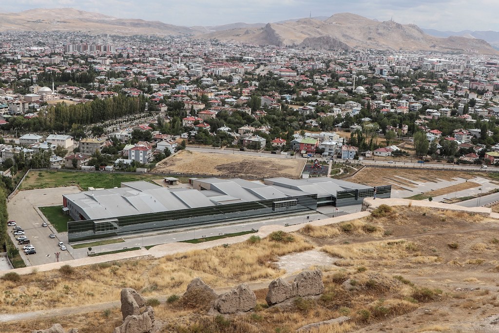


Why visit Edremit
Townapedia lists 15 museums and landmarks, 14 parks and trails, 79 places to eat, 41 places to stay and 5 attractions in and around town.
Highlights include Van Museum and Van Fortress.
Weather in Edremit
Forecast from MET Norway (CC BY 4.0). Full forecast
About Edremit
Edremit (Kurdish: Artemêt; Armenian: Արտամէտ, romanized: Artamet) is a municipality and district of Van Province, Turkey. Its area is 515 km2, and its population is 127,819 (2022). In the 2013 reorganisation, part of the former central district of Van was attached to Edremit District. It covers the southern part of the agglomeration of Van and the adjacent countryside.
From the Wikipedia article Edremit, Van (this version), under CC BY-SA 4.0.
Things to do5



Museums and landmarks15

Van Fortress
Monument and historic site · 11.5 km
Massive stone fortification in Turkey

Van-K'aghaghak'amej
Monument and historic site · 11.3 km
One of the oldest districts of Van, which was famed by self-defense in 1915. Completely destroyed after the genocide. Now it is...
3 more on the map.
Parks, trails and playgrounds14


2 more on the map.
Restaurants and cafes79

bak hele bak kahvaltı kültür sarayı
Restaurant · Breakfast, Kahvaltı · 13.7 km
37 Sıhke Caddesi, Van
Mo-Fr 08:00-17:00
Royal Koç Çağ Kebabı
Restaurant · Turkish · 13.7 km
Mo-Su 09:00-22:00


Altınsu Balık Restoran
Restaurant · 1.5 km
Eski Cami, Sahil Cad No:435, 65170 Edremit/Van
Desotti
Restaurant · Sandwich, Sushi, Tea, Persian, Pasta, Pizza, Spanish, Turkish, Thai · 14.1 km

67 more on the map.
History
The site of the town of Artamet has been settled since ancient times. In the time of the Urartian Kingdom, the Menua Canal was built through the modern-day Edremit district and passes through the town itself. Many of the Urartian inscriptions which mark the canal are located in the Edremit district. The canal continued to irrigate the fertile gardens of the district into the 19th century. The settlement served as a summer residence for the Armenian kings of antiquity. Within the Kingdom of Armenia, Artamet was located in the Tosp district (according to other sources, Hayots Dzor district) of the Vaspurakan province. The medieval Armenian historian Tovma Artsruni claims that Artamet was founded by the 2nd-century BC Armenian king Artaxias I (Artashes) for his queen Satenik. Artamet was the site of a temple to the goddess Anahit; after the Christianization of Armenia, the temple was turned into a church. Until the end of the 8th century, Artamet was one of the possessions of the Armenian noble house of Rshtuni. Afterwards, it was owned by the Artsruni dynasty. Artamet grew significantly under the Artsruni-ruled Kingdom of Vaspurakan, growing into a city; Tadevos Hakobyan estimates its population at that time at over 10,000.
From the History section of Edremit, Van on Wikipedia, under CC BY-SA 4.0.
Where to stay41
Churches and places of worship251
Boyalar Camii
Place of worship · Muslim · 13.7 km
Sıhke Caddesi, Alipaşa Mahallesi
Shopping32
Gas and EV charging24
Schools, colleges and libraries13
Healthcare113
Map of Edremit
250 places. The map loads OpenStreetMap tiles when you open it.
Getting there and nearby towns
Van Ferit Melen International Airport (VAN) is the nearest airport with scheduled flights listed in OpenStreetMap, 8 km away.
- Van 14 km northeast, about 14 min by car
- Gevaş 20 km southwest, about 20 min by car
- Bilgi 36 km south, about 36 min by car
- Aydınocak 36 km west, about 36 min by car
- Yoldöndü 40 km west, about 40 min by car
- Alacabük 45 km west, about 45 min by car
- Kavuştuk 47 km north, about 47 min by car
- Ahlat 77 km northwest, about 1 h 15 min by car
- Hizan 76 km west, about 1 h 15 min by car
- Tatvan 85 km west, about 1 h 30 min by car
Drive times are estimates from straight-line distance, not routes.
Local news
Headlines from INDB.
Reviews, tips and questions
Loading what members have shared...
Sources and licences
- GeoNames (CC BY 4.0): population, coordinates, regions and time zone
- Mapillary (see each image): photos
- OpenStreetMap contributors (ODbL 1.0): places, airports, map data
- Wikidata (CC0 1.0): elevation, founding date, time zone, website, landmarks and historic places
- Wikimedia Commons (see each image): photos
- Wikipedia (CC BY-SA 4.0): overview and history text
Photo credits
- Turkey, Van, Edremit, Salih Karayel, CC BY-SA 4.0
- Edremit, 65170 Edremit-Van, Turkey - panoramio, yuksel maden, CC BY 3.0
- Van Edremit, Brkybyz1, CC BY-SA 4.0
- Van Museum building, Clemens Schmillen, CC BY-SA 4.0
- Van Fortress From Northwest, Bjørn Christian Tørrissen, CC BY-SA 3.0
- OTAltVanOsmanMoschee, Ziegler175, CC BY-SA 4.0
- Van Ulu Cami 4535, Dosseman, CC BY-SA 4.0
- 050413-VanLake-Turkey-IMG 2751-2, Safa.daneshvar, CC0
- 050412-VanLake-Turkey-IMG 2708-2, Safa.daneshvar, CC0
- 050413-VanLake-Turkey-IMG 2740-2, Safa.daneshvar, CC0
- 050413-VanLake-Turkey-IMG 2742-2, Safa.daneshvar, CC0
- 050413-VanLake-Turkey-IMG 2736-2, Safa.daneshvar, CC0
- Süphan Dağı ve Van Gölü, User:Hazreti madem19, CC BY-SA 4.0
- ISS041-E-75526 - View of Earth, Earth Science and Remote Sensing Unit , Lyndon B. Johnson Space Center, Public domain
- ISS065-E-443982 - View of Earth, Earth Science and Remote Sensing Unit , Lyndon B. Johnson Space Center, Public domain
- ISS049-E-33147 - View of Earth, Earth Science and Remote Sensing Unit , Lyndon B. Johnson Space Center, Public domain
- ISS065-E-443981 - View of Earth, Earth Science and Remote Sensing Unit , Lyndon B. Johnson Space Center, Public domain
- ISS065-E-443983 - View of Earth, Earth Science and Remote Sensing Unit , Lyndon B. Johnson Space Center, Public domain
- ISS029-E-19858 - View of Earth, Earth Science and Remote Sensing Unit , Lyndon B. Johnson Space Center, Public domain
- ISS041-E-75525 - View of Earth, Earth Science and Remote Sensing Unit , Lyndon B. Johnson Space Center, Public domain
- ISS043-E-303141 - View of Earth, Earth Science and Remote Sensing Unit , Lyndon B. Johnson Space Center, Public domain
- ISS043-E-303140 - View of Earth, Earth Science and Remote Sensing Unit , Lyndon B. Johnson Space Center, Public domain
- ISS043-E-303142 - View of Earth, Earth Science and Remote Sensing Unit , Lyndon B. Johnson Space Center, Public domain
- Erek Dağından Van, Berfin.gk1, CC BY-SA 4.0
- ISS031-E-36795 - View of Earth, Earth Science and Remote Sensing Unit , Lyndon B. Johnson Space Center, Public domain
- ISS065-E-443984 - View of Earth, Earth Science and Remote Sensing Unit , Lyndon B. Johnson Space Center, Public domain
- ISS031-E-36796 - View of Earth, Earth Science and Remote Sensing Unit , Lyndon B. Johnson Space Center, Public domain
- ISS065-E-443985 - View of Earth, Earth Science and Remote Sensing Unit , Lyndon B. Johnson Space Center, Public domain
- ISS029-E-19265 - View of Earth, Earth Science and Remote Sensing Unit , Lyndon B. Johnson Space Center, Public domain
- Patriachat (38611332300), Herbert Frank from Wien (Vienna), AT, CC BY 2.0
- Street-level photo, azat2020, CC BY-SA 4.0
- Street-level photo, azat2020, CC BY-SA 4.0
- Street-level photo, kaymakam, CC BY-SA 4.0
- Street-level photo, kaymakam, CC BY-SA 4.0
- Street-level photo, kaymakam, CC BY-SA 4.0
- Street-level photo, kaymakam, CC BY-SA 4.0
- Street-level photo, azat2020, CC BY-SA 4.0
- Street-level photo, kaymakam, CC BY-SA 4.0
- Street-level photo, azat2020, CC BY-SA 4.0
- Street-level photo, azat2020, CC BY-SA 4.0
- Street-level photo, azat2020, CC BY-SA 4.0
- Street-level photo, kaymakam, CC BY-SA 4.0
- Street-level photo, kaymakam, CC BY-SA 4.0
- Street-level photo, kaymakam, CC BY-SA 4.0
- Street-level photo, kaymakam, CC BY-SA 4.0


Page built November 8, 2026. Spotted a mistake? Tell us or suggest a place.