


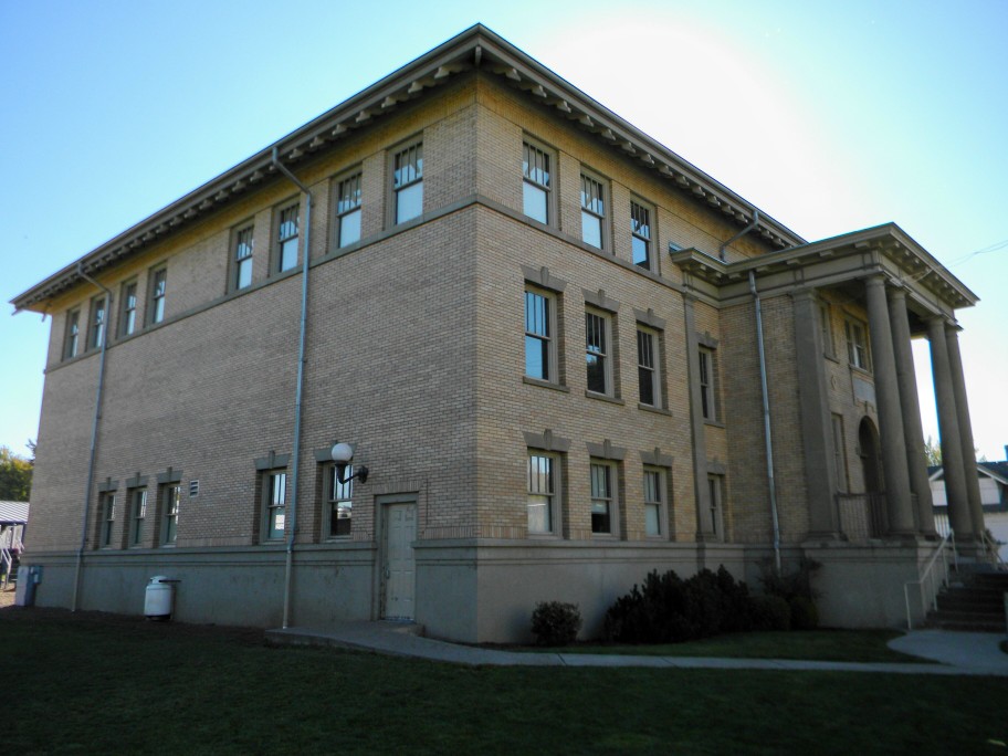

Waitsburg, Washington
Waitsburg is a city of 1,083 people in Walla Walla County, Washington, founded in 1859.
Why visit Waitsburg
Townapedia lists 4 museums and landmarks, 1 park or trail, 4 places to eat and 1 attraction in and around town.
Highlights include Preston Hall and Waitsburg School District 401.
July is the warmest month, with average highs of 88°F; January lows average 26°F.
Weather in Waitsburg
Forecast from the National Weather Service. Full forecast
About Waitsburg
Waitsburg is a city in Walla Walla County, Washington, United States. The population was 1,166 at the 2020 census. Waitsburg has a unique city classification in Washington state, being the state's only city which still operates under its territorial charter.
From the Wikipedia article Waitsburg, Washington (this version), under CC BY-SA 4.0.
Things to do1

Museums and landmarks4
Preston Hall
Monument and historic site · National Register of Historic Places
Listed on the NRHP in Walla Walla County, Washington


Parks, trails and playgrounds1

Restaurants and cafes4



History
Prior to settlement by European American pioneers, the area that is now Waitsburg was home to the Palouse people. The juncture of the Touchet River and Coppei Creek, where Waitsburg would eventually develop, was recorded in the journals of the Lewis and Clark Expedition during their return trip in 1806.
Waitsburg was first settled in 1859 by Robert Kennedy. Another early settler, Albert Gallatin Lloyd, helped settle persistent confrontations with the Palouse people by negotiating a treaty allowing the native population to camp on the land that he claimed. The arrangement established by that treaty, though not backed up by law, continued informally into the 1940s. William Perry Bruce and his wife, Caroline, moved to Waitsburg in 1861, some two decades before Waitsburg was officially incorporated on November 25, 1881. In 1882, they built a large home in the town, which today functions as a museum.
From the History section of Waitsburg, Washington on Wikipedia, under CC BY-SA 4.0.
Churches and places of worship3
Shopping3
Gas and EV charging2
Schools, colleges and libraries5
Healthcare1
Map of Waitsburg
24 places. The map loads OpenStreetMap tiles when you open it.
Climate by month
Monthly table
| Month | High | Low | Rain | Snow |
|---|---|---|---|---|
| Jan | 42°F | 26°F | 2.1 in | 6.3 in |
| Feb | 46°F | 28°F | 1.7 in | 1.9 in |
| Mar | 54°F | 33°F | 2.2 in | 1.0 in |
| Apr | 61°F | 38°F | 1.9 in | 0.1 in |
| May | 70°F | 44°F | 1.8 in | 0.0 in |
| Jun | 77°F | 50°F | 1.2 in | 0.0 in |
| Jul | 88°F | 55°F | 0.4 in | 0.0 in |
| Aug | 87°F | 54°F | 0.5 in | 0.0 in |
| Sep | 77°F | 47°F | 0.7 in | 0.0 in |
| Oct | 63°F | 38°F | 1.5 in | 0.1 in |
| Nov | 49°F | 31°F | 2.4 in | 1.2 in |
| Dec | 41°F | 26°F | 2.3 in | 5.2 in |
U.S. Climate Normals 1991-2020 for Dayton 1 Wsw Hcn (8 mi away), NOAA NCEI.
People and cost of living
American Community Survey 5-year estimates, 2020-2024, U.S. Census Bureau. Estimates have margins of error, larger for small towns.
Disaster history
Walla Walla County has had 9 federal disaster declarations since 2000, most often for floods.
- 2020-04-23: Severe Storms, Flooding, Landslides, And Mudslides (Flood)
- 2020-03-22: Covid-19 Pandemic (Biological)
- 2020-03-13: Covid-19 (Biological)
- 2017-04-21: Severe Winter Storms, Flooding, Landslides, Mudslides (Flood)
- 2015-07-21: Blue Creek Fire (Fire)
- 2009-03-02: Severe Winter Storm And Record And Near Record Snow (Severe Storm)
OpenFEMA disaster declarations summaries.
Getting there and nearby towns
Walla Walla Regional Airport (ALW) is the nearest airport with scheduled flights listed in OpenStreetMap, 14 miles away.
- Dayton 9 mi east, about 14 min by car
- Walla Walla 17 mi southwest, about 27 min by car
- Garrett 19 mi southwest, about 31 min by car
- Milton-Freewater 26 mi southwest, about 42 min by car
- Pomeroy 30 mi northeast, about 48 min by car
- Burbank 40 mi west, about 1 h by car
- Connell 42 mi northwest, about 1 h 15 min by car
- Pasco 46 mi west, about 1 h 15 min by car
- Kennewick 49 mi west, about 1 h 15 min by car
- Richland 55 mi west, about 1 h 30 min by car
Drive times are estimates from straight-line distance, not routes.
Local news
Headlines from INDB, the NEMICO news database.
Reviews, tips and questions
Loading what members have shared...
Sources and licences
- NCES EDGE (Public domain): public schools
- NOAA NCEI U.S. Climate Normals 1991-2020 (Public domain): climate by month
- OpenFEMA (Public domain): disaster declarations
- OpenStreetMap contributors (ODbL 1.0): places, airports, map data
- U.S. Census Bureau (Public domain): population, income, housing, education, commute
- Wikidata (CC0 1.0): elevation, founding date, time zone, website, landmarks and historic places
- Wikimedia Commons (see each image): photos
- Wikipedia (CC BY-SA 4.0): overview and history text
Photo credits
- Waitsburg-Washington, Unknown author, CC BY-SA 3.0
- Preston Hall, Jon Roanhaus, CC BY-SA 3.0
Page built October 30, 2026. Spotted a mistake? Tell us or suggest a place.