
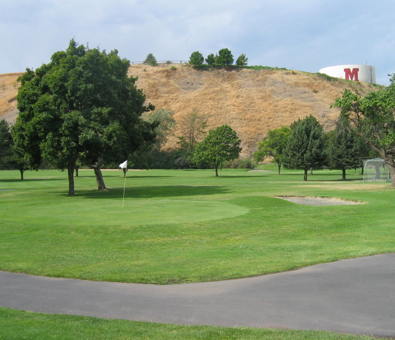


Milton-Freewater, Oregon
Milton-Freewater is a city of 7,036 people in Umatilla County, Oregon, founded in 1950.
Why visit Milton-Freewater
Townapedia lists 1 museum or landmark, 8 parks and trails, 12 places to eat, 2 places to stay and 1 attraction in and around town.
Highlights include Columbia Heights.
July is the warmest month, with average highs of 90°F; December lows average 30°F.
Weather in Milton-Freewater
Forecast from the National Weather Service. Full forecast
About Milton-Freewater
Milton-Freewater is a city in Umatilla County, Oregon, United States. The city received its current name in 1951 when the neighboring rival cities of Milton and Freewater voted to merge. The population was 7,151 at the 2020 census. It is part of the Pendleton–Hermiston Micropolitan Statistical Area.
From the Wikipedia article Milton-Freewater, Oregon (this version), under CC BY-SA 4.0.
Things to do1

Museums and landmarks1

Parks, trails and playgrounds8


Restaurants and cafes12


Jubilee Coffee House
Cafe · Coffee Shop
311 South Main Street, Milton Freewater

History
First settled in 1868, the community was incorporated as Milton by 1873. It is uncertain how the name was chosen; perhaps in hopes of building a mill, or perhaps in honor of English poet John Milton.
Freewater received its name from the offer of free residential water rights to attract new settlers. Before that name was chosen other proposed names had been New Walla Walla and Wallaette. The town was located to the north of and directly adjacent to Milton.
In 1936, a magnitude 6.1 earthquake centered 6 miles (9.7 km) to the northwest caused significant damage in and around Milton-Freewater. This earthquake was followed by numerous aftershocks and had a temporary effect on the water table.
From the History section of Milton-Freewater, Oregon on Wikipedia, under CC BY-SA 4.0.
Where to stay2
Churches and places of worship3
Saint Francis of Assisi Catholic Church
Church · Roman Catholic · 0.9 mi
925 Vining Street, Milton-Freewater
The Church of Jesus Christ of Latter-day Saints
Church · Latter Day Saints · 1.0 mi
Shopping2
Schools, colleges and libraries8
Blue Mountain Community College - Milton-Freewater
School · 0.4 mi
311 North Columbia Street, Milton-Freewater
Healthcare1
Map of Milton-Freewater
38 places. The map loads OpenStreetMap tiles when you open it.
Climate by month
Monthly table
| Month | High | Low | Rain | Snow |
|---|---|---|---|---|
| Jan | 44°F | 30°F | 1.8 in | 2.4 in |
| Feb | 49°F | 33°F | 1.5 in | 1.3 in |
| Mar | 58°F | 39°F | 1.7 in | 0.1 in |
| Apr | 65°F | 44°F | 1.6 in | 0.0 in |
| May | 74°F | 50°F | 1.8 in | 0.0 in |
| Jun | 80°F | 56°F | 1.2 in | 0.0 in |
| Jul | 90°F | 63°F | 0.3 in | 0.0 in |
| Aug | 89°F | 62°F | 0.4 in | 0.0 in |
| Sep | 80°F | 55°F | 0.6 in | 0.0 in |
| Oct | 66°F | 44°F | 1.2 in | 0.0 in |
| Nov | 52°F | 36°F | 1.9 in | 0.3 in |
| Dec | 44°F | 30°F | 2.1 in | 3.1 in |
U.S. Climate Normals 1991-2020 for Milton Freewater Hcn (1 mi away), NOAA NCEI.
People and cost of living
American Community Survey 5-year estimates, 2020-2024, U.S. Census Bureau. Estimates have margins of error, larger for small towns.
Disaster history
Umatilla County has had 11 federal disaster declarations since 2000, most often for fires.
- 2026-08-09: Hagen Fire (Fire)
- 2026-07-16: Lower Dry Creek Fire (Fire)
- 2025-01-01: Wildfires (Fire)
- 2024-07-21: Battle Mountain Fire Complex (Fire)
- 2020-04-03: Severe Storms, Flooding, Landslides, And Mudslides (Flood)
- 2020-03-28: Covid-19 Pandemic (Biological)
OpenFEMA disaster declarations summaries.
Getting there and nearby towns
Walla Walla Regional Airport (ALW) is the nearest airport with scheduled flights listed in OpenStreetMap, 12 miles away.
- Umapine 6 mi northwest, about 10 min by car
- Walla Walla 10 mi north, about 15 min by car
- Pendleton 27 mi southwest, about 44 min by car
- Kennewick 42 mi northwest, about 1 h by car
- Pasco 42 mi northwest, about 1 h by car
- Hermiston 44 mi west, about 1 h 15 min by car
- La Grande 45 mi south, about 1 h 15 min by car
- Island City 45 mi south, about 1 h 15 min by car
- Richland 50 mi northwest, about 1 h 15 min by car
- West Richland 54 mi northwest, about 1 h 30 min by car
Drive times are estimates from straight-line distance, not routes.
Local news
Headlines from INDB, the NEMICO news database.
Reviews, tips and questions
Loading what members have shared...
Sources and licences
- NCES EDGE (Public domain): public schools
- NOAA NCEI U.S. Climate Normals 1991-2020 (Public domain): climate by month
- OpenFEMA (Public domain): disaster declarations
- OpenStreetMap contributors (ODbL 1.0): places, airports, map data
- U.S. Census Bureau (Public domain): population, income, housing, education, commute
- Wikidata (CC0 1.0): elevation, founding date, time zone, website
- Wikimedia Commons (see each image): photos
- Wikipedia (CC BY-SA 4.0): overview and history text
Photo credits
- MiltonFreewaterGolf, Bobjgalindo, CC BY-SA 4.0
- Central Middle School - Milton-Freewater Oregon, Ian Poellet, CC BY-SA 3.0
- Tomato packing warehouse, Milton-Freewater, Oregon (3388158174), OSU Special Collections & Archives : Commons, No restrictions
- Tomato packing shed, Milton-Freewater, Oregon (3388159528), OSU Special Collections & Archives : Commons, No restrictions
- 42-20230521McLoughlinHSAerial, FriendlyToaster, CC0
- 04-20230521McLoughlinHS, FriendlyToaster, CC0
- 35-20230521McLoughlinHS, FriendlyToaster, CC0
- 07-20230521McLoughlinHS, FriendlyToaster, CC0
- McLoughlin High School Southwest Back, FriendlyToaster, CC0
- 09-20230521McLoughlinHS, FriendlyToaster, CC0
- 06-20230521McLoughlinHS, FriendlyToaster, CC0
- 05-20230521McLoughlinHS, FriendlyToaster, CC0
- 43-20230521McLoughlinHSAerial, FriendlyToaster, CC0
- 36-20230521McLoughlinHS, FriendlyToaster, CC0
- McLoughlin High School Gymnasium, FriendlyToaster, CC0
- McLoughlin High School from the South, FriendlyToaster, CC0
- Front of McLoughlin High School from South, FriendlyToaster, CC0
- McLoughlin High School from South, FriendlyToaster, CC0
- 44-20230521McLoughlinHSAerial, FriendlyToaster, CC0
- 41-20230521McLoughlinHSAerial, FriendlyToaster, CC0
- McLoughlin High School Roof Shields, FriendlyToaster, CC0
- Gymnasium Title at McLoughlin High School, FriendlyToaster, CC0
- McLoughlin Memorial Stadium Marker, FriendlyToaster, CC0
- 49-20230521McLoughlinHSAerial, FriendlyToaster, CC0
- McLoughlin High School Entrance, FriendlyToaster, CC0
- McLoughlin High School Entrance Titling, FriendlyToaster, CC0
- McLoughlin High School Front Close Up, FriendlyToaster, CC0
- McLoughlin High School Entrance Closeup, FriendlyToaster, CC0
- McLoughlinHighSchoolAerial1948Yearbook, McLoughlin Union High School, Public domain
- Relief of John McLoughlin on McLoughlin High School, FriendlyToaster, CC0
- Front of McLoughlin High School, FriendlyToaster, CC0
- Front of McLoughlin High School Unedited, FriendlyToaster, CC0
- 37-20230521McLoughlinHS, FriendlyToaster, CC0
- 52-20230521McLoughlinHSAerial, FriendlyToaster, CC0
- 22-20230521McLoughlinHS, FriendlyToaster, CC0
- 21-20230521McLoughlinHS, FriendlyToaster, CC0
- McLoughlin High School Entrance from North, FriendlyToaster, CC0


Page built October 30, 2026. Spotted a mistake? Tell us or suggest a place.