


Wayzata, Minnesota
Wayzata is a city of 4,354 people in Hennepin County, Minnesota, founded in 1854.
Why visit Wayzata
Townapedia lists 3 museums and landmarks, 20 parks and trails, 17 places to eat, 2 places to stay and 1 attraction in and around town.
Highlights include Big Island Amusement Park, Great Northern Depot, Minnehaha and Wayzata Country Club.
July is the warmest month, with average highs of 82°F; January lows average 7°F, and about 54 inches of snow fall in a normal year.
Weather in Wayzata
Forecast from the National Weather Service. Full forecast
About Wayzata
Wayzata is a city in Hennepin County, Minnesota, United States. The population was 4,434 at the 2020 census. A suburb of the Twin Cities, Wayzata is located about 9 miles (14 km) west of Minneapolis along the northern shore of Lake Minnetonka, the state's ninth-largest lake.
From the Wikipedia article Wayzata, Minnesota (this version), under CC BY-SA 4.0.
Things to do1
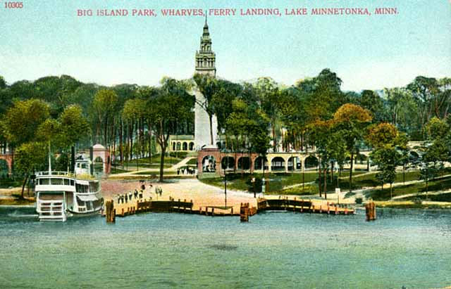
Big Island Amusement Park
Monument and historic site · 3.2 mi
Former American amusement park
Museums and landmarks3

Great Northern Depot
Monument and historic site · National Register of Historic Places
Railway station in Wayzata, Minnesota, United States


Minnehaha
Monument and historic site · National Register of Historic Places
US historic restored ship
Parks, trails and playgrounds20



Wayzata Community Sailing Center
Marina and boat launch · 0.7 mi
456 Arlington Circle, Wayzata

8 more on the map.
Restaurants and cafes17


Starbucks
Cafe · Coffee Shop · 1.0 mi
1330 Wayzata Boulevard, Wayzata
Mo-Fr 05:00-19:30; Sa 05:30-19:30; Su 05:30-19:00
The Original Pancake House
Restaurant · Breakfast, Pancake · 1.8 mi
1415 County Road 101, Plymouth
Mo-Fr 06:30-14:00; Sa-Su 06:30-15:00
Lucky Street
Restaurant · 1.8 mi
County Road 101, Plymouth
Tu-Th 16:00-19:30;Fr-Sa 11:00-20:00;Su 12:00-19:30
Sakana Sushi & Asian Bistro
Restaurant · Sushi
Su-Th 11:00-14:30,16:30-21:00; Fr-Sa 11:00-14:30,16:30-21:30


5 more on the map.
Where to stay2
Churches and places of worship6
The Church of Jesus Christ of Latter-day Saints
Church · Mormon · 1.9 mi
330 Vicksburg Lane North, Plymouth
Shopping1
Gas and EV charging2
Schools, colleges and libraries43
Healthcare2
Map of Wayzata
97 places. The map loads OpenStreetMap tiles when you open it.
Climate by month
Monthly table
| Month | High | Low | Rain | Snow |
|---|---|---|---|---|
| Jan | 24°F | 7°F | 0.9 in | 10.1 in |
| Feb | 29°F | 11°F | 1.0 in | 10.1 in |
| Mar | 42°F | 23°F | 1.9 in | 9.0 in |
| Apr | 57°F | 35°F | 3.3 in | 5.1 in |
| May | 69°F | 48°F | 4.5 in | 0.0 in |
| Jun | 78°F | 58°F | 4.6 in | 0.0 in |
| Jul | 82°F | 63°F | 4.5 in | 0.0 in |
| Aug | 80°F | 61°F | 4.2 in | 0.0 in |
| Sep | 72°F | 52°F | 3.5 in | 0.0 in |
| Oct | 57°F | 39°F | 3.0 in | 0.8 in |
| Nov | 41°F | 26°F | 1.9 in | 6.9 in |
| Dec | 28°F | 14°F | 1.4 in | 12.3 in |
U.S. Climate Normals 1991-2020 for New Hope (7 mi away), NOAA NCEI.
People and cost of living
American Community Survey 5-year estimates, 2020-2024, U.S. Census Bureau. Estimates have margins of error, larger for small towns.
Disaster history
Hennepin County has had 10 federal disaster declarations since 2000, most often for floods.
- 2020-04-07: Covid-19 Pandemic (Biological)
- 2020-03-13: Covid-19 (Biological)
- 2016-11-02: Severe Storms And Flooding (Flood)
- 2014-07-21: Severe Storms, Straight-Line Winds, Flooding, Landslides, And Mudslides (Flood)
- 2013-07-25: Severe Storms, Straight-Line Winds, And Flooding (Severe Storm)
- 2011-06-07: Severe Storms And Tornadoes (Severe Storm)
OpenFEMA disaster declarations summaries.
Getting there and nearby towns
Crystal Airport (MIC) is the nearest airport with scheduled flights listed in OpenStreetMap, 10 miles away.
- Deephaven 3 mi south, about 4 min by car
- Long Lake 3 mi west, about 5 min by car
- Minnetonka 4 mi southeast, about 6 min by car
- Orono 4 mi west, about 6 min by car
- Plymouth 4 mi northeast, about 7 min by car
- Medina 5 mi northwest, about 8 min by car
- Excelsior 5 mi southwest, about 9 min by car
- Tonka Bay 5 mi southwest, about 8 min by car
- Hopkins 6 mi southeast, about 10 min by car
- Shorewood 6 mi southwest, about 10 min by car
Drive times are estimates from straight-line distance, not routes.
Local news
Headlines from INDB, the NEMICO news database.
Reviews, tips and questions
Loading what members have shared...
Sources and licences
- NCES EDGE (Public domain): public schools
- NOAA NCEI U.S. Climate Normals 1991-2020 (Public domain): climate by month
- OpenFEMA (Public domain): disaster declarations
- OpenStreetMap contributors (ODbL 1.0): places, airports, map data
- U.S. Census Bureau (Public domain): population, income, housing, education, commute
- Wikidata (CC0 1.0): elevation, founding date, time zone, website, landmarks and historic places
- Wikimedia Commons (see each image): photos
- Wikipedia (CC BY-SA 4.0): overview and history text
Photo credits
- DowntownWayzata1, 123dieinafire ( talk ), CC BY 3.0
- Wayzata, Minnesota U.S. Post Office (42034787002), Tony Webster from Minneapolis, Minnesota, United States, CC BY 2.0
- Wayzata Bay Wreck, Maritime Heritage Minnesota, CC0
- Wayzata Depot 1, Elkman, CC BY-SA 3.0
- Wayzata Depot 7, Elkman, CC BY-SA 4.0
- Wayzata Library, Paul2520, CC BY-SA 4.0
- Wayzata Community Church, Minnesota - United Church of Christ Congregation (41935532331), Tony Webster from Minneapolis, Minnesota, United States, CC BY 2.0
- Juut Salon Spa - Wayzata, Minnesota (41935536721), Tony Webster from Minneapolis, Minnesota, United States, CC BY 2.0
- Chuck and Don's Pet Food and Supplies, Wayzata, Minnesota (41935534911), Tony Webster from Minneapolis, Minnesota, United States, CC BY 2.0
- Highway 12 Wayzata Minnesota (23822490595), Tony Webster from Portland, Oregon, CC BY-SA 2.0
- Gray's Bay, Wayzata (1511835077), Tony Webster from Portland, Oregon, United States, CC BY 2.0
- Steamboat Minnehaha in dry dock, Aaron Person, CC BY-SA 4.0
- Big Island Park, Unknown author Unknown author, Public domain
- Senator Paul Anderson and Senator Dave Senjem, Minnesota Senate Republican Caucus, CC BY 2.0
- Senator Dave Senjem (cropped), Minnesota Senate Republican Caucus, CC BY 2.0
- Pomeranianhenna, Jessicawongsou, CC BY-SA 4.0
- The Retreat - panoramio, Jayesh Naithani, CC BY-SA 3.0
- Epistrophella emarginata - iNaturalist 553868473, Thomas Boe, CC BY 4.0
- 01 Gray's Bay, Lake Minnetonka, Minnesota 2307444116 o, Tony Webster, CC BY-SA 3.0
- The Old Stone Arch, Widgetkid, CC BY-SA 4.0
- Footprints in the Snow in Minnesota, Gina Paulucci, CC BY-SA 3.0
- Snowy Landscape in Minnesota, Gina Paulucci, CC BY-SA 3.0
- Snow scene in Minnesota, Gina Paulucci, CC BY-SA 3.0
- French Normandy cottage, GinaPaulucci, CC BY-SA 3.0
- Springer Spaniel in the Snow, Gina Paulucci, CC BY-SA 3.0
- Ducklings (52147016685), Chad Davis from Minneapolis, United States, CC BY 2.0


Page built October 30, 2026. Spotted a mistake? Tell us or suggest a place.