


West Brattleboro, Vermont
West Brattleboro is a community of 2,749 people in Windham County, Vermont.
Why visit West Brattleboro
Townapedia lists 19 museums and landmarks, 6 parks and trails, 5 places to eat, 2 places to stay and 2 attractions in and around town.
Highlights include Creamery Covered Bridge, Arthur D. and Emma J. Wyatt House and Brattleboro Country Club.
July is the warmest month, with average highs of 81°F; January lows average 12°F.
Weather in West Brattleboro
Forecast from the National Weather Service. Full forecast
About West Brattleboro
West Brattleboro is a census-designated place (CDP) in the town of Brattleboro, Vermont, United States. As of the 2020 census, West Brattleboro had a population of 2,803.
From the Wikipedia article West Brattleboro, Vermont (this version), under CC BY-SA 4.0.
Things to do2


Museums and landmarks19

Creamery Covered Bridge
Bridge · National Register of Historic Places · 0.8 mi
Covered bridge in West Brattleboro
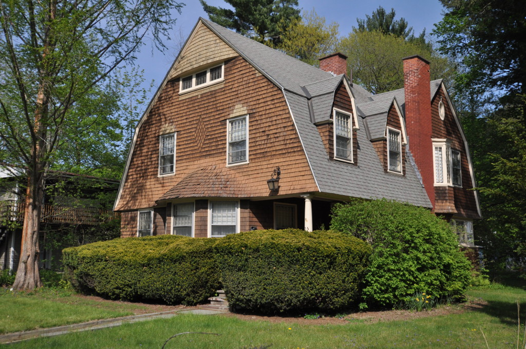
Arthur D. and Emma J. Wyatt House
Monument and historic site · National Register of Historic Places · 2.1 mi
House in Brattleboro, Vermont

Brattleboro Downtown Historic District
Monument and historic site · National Register of Historic Places · 2.1 mi
Historic district in Vermont, United States

Brattleboro Retreat
Monument and historic site · National Register of Historic Places · 1.9 mi
Private not-for-profit mental health and addictions hospital in Brattleboro, Vermont, United States

Brooks House
Monument and historic site · National Register of Historic Places · 2.1 mi
Built for hotelier George Brooks in Brattleboro, Vermont, United States

Canal Street Schoolhouse
Monument and historic site · National Register of Historic Places · 2.2 mi
Historic school building in Brattleboro Vermont

Canal Street–Clark Street Neighborhood Historic District
Monument and historic site · National Register of Historic Places · 2.1 mi
Historic district in Brattleboro, Vermont, United States

Deacon John Holbrook House
Monument and historic site · National Register of Historic Places · 1.9 mi
Historic house at 80 Linden Street in Brattleboro, Vermont

Dickinson Estate Historic District
Monument and historic site · National Register of Historic Places · 2.9 mi
Estate in Brattleboro, Vermont, United States

Estey Organ Company Factory
Monument and historic site · National Register of Historic Places · 1.8 mi
Historic buildings in Brattleboro, Vermont, United States

Guilford Country Store
Monument and historic site · National Register of Historic Places · 3.0 mi
Tavern in Guilford, Vermont


Homestead-Horton Neighborhood Historic District
Monument and historic site · National Register of Historic Places · 2.1 mi
Historic district in Brattleboro, Vermont
7 more on the map.
Parks, trails and playgrounds6



Restaurants and cafes5




Where to stay2
Churches and places of worship10
Christ Church
Church · National Register of Historic Places · 3.1 mi
Church of Christ
Church · Nondenominational · 1.2 mi
303 Western Avenue, Brattleboro
Trinity Lutheran Church
Church · Lutheran · 1.4 mi
161 Western Avenue, Brattleboro
Shopping1
Gas and EV charging2
Schools, colleges and libraries10
Map of West Brattleboro
57 places. The map loads OpenStreetMap tiles when you open it.
Climate by month
Monthly table
| Month | High | Low | Rain |
|---|---|---|---|
| Jan | 31°F | 12°F | 3.2 in |
| Feb | 33°F | 14°F | 3.0 in |
| Mar | 42°F | 21°F | 3.6 in |
| Apr | 56°F | 33°F | 3.8 in |
| May | 67°F | 44°F | 3.4 in |
| Jun | 75°F | 53°F | 5.1 in |
| Jul | 81°F | 58°F | 4.8 in |
| Aug | 79°F | 56°F | 4.2 in |
| Sep | 72°F | 49°F | 4.0 in |
| Oct | 60°F | 38°F | 4.6 in |
| Nov | 47°F | 28°F | 3.6 in |
| Dec | 36°F | 19°F | 3.8 in |
U.S. Climate Normals 1991-2020 for Walpole 2S Nepp (15 mi away), NOAA NCEI.
People and cost of living
American Community Survey 5-year estimates, 2020-2024, U.S. Census Bureau. Estimates have margins of error, larger for small towns.
Disaster history
Windham County has had 18 federal disaster declarations since 2000, most often for severe storms.
- 2024-08-08: Tropical Depression Debby (Tropical Storm)
- 2024-03-02: Severe Storm And Flooding (Severe Storm)
- 2023-07-14: Severe Storms, Flooding, Landslides, And Mudslides (Flood)
- 2023-07-10: Flooding (Flood)
- 2021-09-29: Severe Storm And Flooding (Flood)
- 2021-08-22: Tropical Storm Henri (Hurricane)
OpenFEMA disaster declarations summaries.
Getting there and nearby towns
Dillant-Hopkins Airport (EEN) is the nearest airport with scheduled flights listed in OpenStreetMap, 17 miles away.
- Brattleboro 2 mi east, about 3 min by car
- Hinsdale 7 mi southeast, about 12 min by car
- Winchester 12 mi southeast, about 20 min by car
- Northfield 13 mi southeast, about 22 min by car
- West Swanzey 14 mi east, about 23 min by car
- Keene 16 mi northeast, about 26 min by car
- Greenfield 17 mi south, about 27 min by car
- Turners Falls 18 mi south, about 29 min by car
- Shelburne Falls 19 mi southwest, about 30 min by car
- Bellows Falls 21 mi north, about 33 min by car
Drive times are estimates from straight-line distance, not routes.
Local news
Headlines from INDB, the NEMICO news database.
Reviews, tips and questions
Loading what members have shared...
Sources and licences
- NCES EDGE (Public domain): public schools
- NOAA NCEI U.S. Climate Normals 1991-2020 (Public domain): climate by month
- OpenFEMA (Public domain): disaster declarations
- OpenStreetMap contributors (ODbL 1.0): places, airports, map data
- U.S. Census Bureau (Public domain): population, income, housing, education, commute
- Wikidata (CC0 1.0): elevation, founding date, time zone, website, landmarks and historic places
- Wikimedia Commons (see each image): photos
- Wikipedia (CC BY-SA 4.0): overview and history text
Photo credits
- 1893 Building, West Brattleboro VT, John Phelan, CC BY-SA 4.0
- West Brattleboro Baptist Church, Beyond My Ken, CC BY-SA 4.0
- First Congregational Church 880 VT-9 West Brattleboro VT April 2024 01, Artaxerxes, CC BY 4.0
- First Congregational Church 880 VT-9 West Brattleboro VT April 2024 03, Artaxerxes, CC BY 4.0
- First Congregational Church 880 VT-9 West Brattleboro VT April 2024 02, Artaxerxes, CC BY 4.0
- Creamery Covered Bridge West Brattleboro, Beyond My Ken, CC BY-SA 4.0
- Brattleboro Vermont Amtrak station, Beyond My Ken, CC BY-SA 4.0
- The Abbott Brattleboro, Beyond My Ken, CC BY-SA 4.0
- Brooks House long, Beyond My Ken, CC BY-SA 4.0
- Post Office and Court House Brattleboro, Beyond My Ken, CC BY-SA 4.0
- BrattleboroVT WyattHouse, Magicpiano, CC BY-SA 3.0
- Old Estey Organ factory buildings, Brattleboro, Vt., Qrpnut, CC BY-SA 3.0
- Christ Church Guilford Vermont, Beyond My Ken, CC BY-SA 4.0
- Canal Street School, Brattleboro, Vermont, Kenneth C. Zirkel, CC BY 4.0
- 2016 Guilford Country Store Broad Brook House Guilford Vermont, Beyond My Ken, CC BY-SA 4.0
- Deacon John Holbrooke House 80 Linden Street Brattleboro Vermont, Beyond My Ken, CC BY-SA 4.0
- BrattleboroVT DickinsonEstateHD 2, Magicpiano, CC BY-SA 3.0
- Brattleboro Retreat 1, Beyond My Ken, CC BY-SA 4.0
- BrattleboroVT HomesteadHortonHD 3, Magicpiano, CC BY-SA 3.0
- Tontine House, Guilford, Vt. after renovation and conversion to affordable housing in 2010, Qrpnut, CC BY-SA 3.0
- Brattleboro Museum & Art Center, Beyond My Ken, CC BY-SA 4.0
- Brattleboro Historical Society Jeremiah Beal House, Beyond My Ken, CC BY-SA 4.0
- Lewis Grout House Western Avenue and Bonnyvale Road Brattleboro, Beyond My Ken, CC BY-SA 4.0
- 1159 Western Avenue, Brattleboro, Vermont, Beyond My Ken, CC BY-SA 4.0
- First Congregational Church Brattleboro, Beyond My Ken, CC BY-SA 4.0
- 20240911 Edible Brattleboro Food Forest (53999254981), usfs_Eastern_Region, Public domain
- 20240911 Edible Brattleboro Food Forest 2 (53999678620), usfs_Eastern_Region, Public domain
- 790 Western Avenue, Brattleboro, Vermont, Beyond My Ken, CC BY-SA 4.0
- Thrifting New England 55 Marlboro Road Brattleboro VT February 2026 02, Artaxerxes, CC BY 4.0
- Thrifting New England 55 Marlboro Road Brattleboro VT February 2026 03, Artaxerxes, CC BY 4.0
- Thrifting New England 55 Marlboro Road Brattleboro VT February 2026 01, Artaxerxes, CC BY 4.0
- BrattleboroVT SamuelSmithFarmstead, Magicpiano, CC BY-SA 3.0
- BrattleboroVT WilliamHarrisHouse, Magicpiano, CC BY-SA 3.0
- Creamery-covered-bridge, Elaine Stottlar, CC BY-SA 3.0
- Covered Bridge (6236988797), Tony Hisgett from Birmingham, UK, CC BY 2.0
- When in Vermont, there is no shame with embracing the cliché. 10329943735, stannate from St. Louis, MO, US, CC BY-SA 2.0
- Green Mountain Chapel, Brattleboro, Vermont, Beyond My Ken, CC BY-SA 4.0
- Bombardier trail groomer Living Memorial Park 61 Guilford Street Brattleboro VT August 2023, Artaxerxes, CC BY-SA 4.0
- 382 Western Avenue Brattleboro Vermont, Beyond My Ken, CC BY-SA 4.0
- 160 Western Avenue Brattleboro, Beyond My Ken, CC BY-SA 4.0


Page built October 30, 2026. Spotted a mistake? Tell us or suggest a place.