


West Richland, Washington
West Richland is a city of 17,586 people in Benton County, Washington, founded in 1955.
Why visit West Richland
Townapedia lists 4 museums and landmarks, 24 parks and trails, 23 places to eat, 2 places to stay and 6 attractions in and around town.
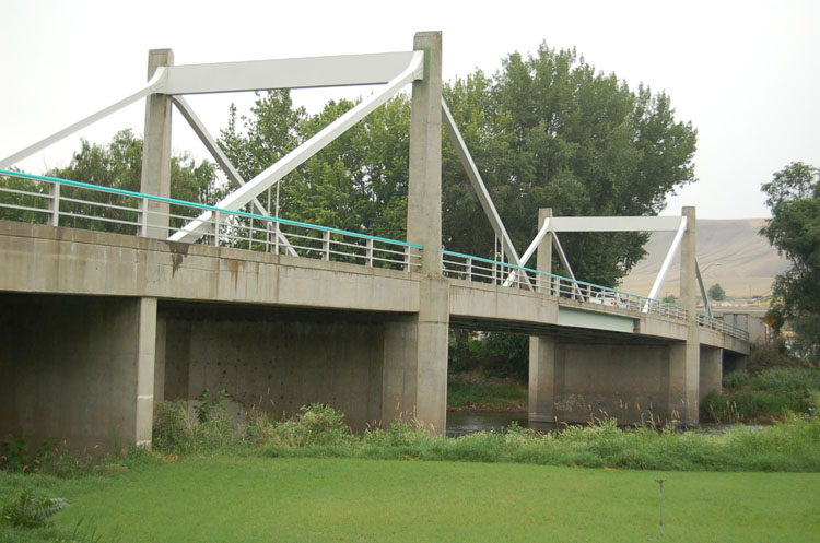
Highlights include Duportail Bridge, Candy Mountain, Benton City – Kiona Bridge and Gold Coast Historic District.
July is the warmest month, with average highs of 89°F; December lows average 28°F.
Weather in West Richland
Forecast from the National Weather Service. Full forecast
About West Richland
West Richland is a city in Benton County, Washington. The population was 16,295 at the time of the 2020 census. The city is part of the Tri-Cities metropolitan area, whose principal cities (the Tri-Cities) are Richland, Kennewick, and Pasco.
From the Wikipedia article West Richland, Washington (this version), under CC BY-SA 4.0.
Things to do6


Museums and landmarks4
Benton City – Kiona Bridge
Bridge · National Register of Historic Places · 5.9 mi
Bridge in United States of America


Gold Coast Historic District
Monument and historic site · National Register of Historic Places · 5.7 mi
Historic district in Washington, United States

Parks, trails and playgrounds24



12 more on the map.
Restaurants and cafes23

Italiano's Serious Pies & Pasta Restaurant
Restaurant · Italian · 2.6 mi
4850 Paradise Way, West Richland
Tu-Su 11:00-21:00; Mo off; PH unknown

Lil' Moon Diner
Restaurant · American, Breakfast · 2.7 mi
3790 West Van Giesen Street, West Richland
07:00-15:00
Brick House Pizza
Restaurant · Pizza · 2.7 mi
3791 West Van Giesen Street, West Richland
11:00-20:30

Wake Up Call
Cafe · Coffee Shop · 2.6 mi
4033 West Van Giesen Street, West Richland
Mo-Fr 05:00-19:00; Sa 06:00-19:00; Su 07:00-19:00

Guadalajara Style
Restaurant · Mexican · 2.6 mi
3960 West Van Giesen Street, West Richland
11 more on the map.
History
The original people of the region were the Chemnapum Indians (closely related to the Wanapum tribe), living near the mouth of the Yakima River. Lewis and Clark passed through the area in 1805, and an expedition of the Army Corps of Topographical Engineers headed by Robert E Johnson mapped the Yakima Valley in 1841.
In 1853, a road was authorized by Congress to pass through the Yakima Valley, and passed through present-day West Richland; however, settlement did not properly begin until the late 1870s. The first schoolhouse was built in 1896 on the Van Horn Property just south of what is now Van Giesen Street. Benton County was created in 1905, Richland was incorporated in 1906, and the West Richland area was known as 'Lower Yakima'.
An irrigation canal from the north side of Horn Rapids Dam was built in 1908 to bring water into Richland.
The Yellowstone Trail, a national highway stretching from Albany, New York, to Seattle, was located through the Yakima Valley in 1917 and 1918. It crossed the Fallon Bridge between Richland and West Richland and then proceeded directly west to Kiona.
From the History section of West Richland, Washington on Wikipedia, under CC BY-SA 4.0.
Where to stay2
Churches and places of worship7
Grace and Truth Community Church
Church · Southern Baptist · 2.5 mi
1301 Bombing Range Road, West Richland
Church of Jesus Christ of Latter-Day Saints Meeting House
Church · Latter Day Saints · 3.0 mi
5885 Holly Way, West Richland
The Church of Jesus Christ of Latter-day Saints
Church · Mormon · 3.6 mi
3701 Watkins Way
Shopping2
Baum's House of Chocolate
Shop · 2.6 mi
4033 West Van Giesen Street, West Richland
Gas and EV charging4
Schools, colleges and libraries26
Healthcare1
Yoke's Fresh Market Pharmacy
Clinic and pharmacy · 2.5 mi
1401 Bombing Range Road, West Richland
Map of West Richland
99 places. The map loads OpenStreetMap tiles when you open it.
Climate by month
Monthly table
| Month | High | Low | Rain |
|---|---|---|---|
| Jan | 41°F | 29°F | 1.0 in |
| Feb | 48°F | 30°F | 0.7 in |
| Mar | 57°F | 35°F | 0.6 in |
| Apr | 65°F | 41°F | 0.6 in |
| May | 74°F | 48°F | 0.6 in |
| Jun | 80°F | 54°F | 0.6 in |
| Jul | 89°F | 60°F | 0.2 in |
| Aug | 88°F | 59°F | 0.1 in |
| Sep | 79°F | 51°F | 0.3 in |
| Oct | 64°F | 42°F | 0.5 in |
| Nov | 49°F | 34°F | 0.9 in |
| Dec | 40°F | 28°F | 1.1 in |
U.S. Climate Normals 1991-2020 for Richland (6 mi away), NOAA NCEI.
People and cost of living
American Community Survey 5-year estimates, 2020-2024, U.S. Census Bureau. Estimates have margins of error, larger for small towns.
Disaster history
Benton County has had 11 federal disaster declarations since 2000, most often for floods.
- 2025-12-12: Severe Storms, Straight-Line Winds, Flooding, Landslides, And Mudslides (Flood)
- 2020-03-22: Covid-19 Pandemic (Biological)
- 2020-03-13: Covid-19 (Biological)
- 2017-04-21: Severe Winter Storms, Flooding, Landslides, Mudslides (Flood)
- 2016-08-01: South Ward Gap Fire (Fire)
- 2009-08-22: Dry Creek Fire Complex (Fire)
OpenFEMA disaster declarations summaries.
Getting there and nearby towns
Richland Airport (RLD) is the nearest airport with scheduled flights listed in OpenStreetMap, 4 miles away.
- Richland 5 mi east, about 8 min by car
- Benton City 6 mi southwest, about 9 min by car
- Kennewick 13 mi southeast, about 21 min by car
- Pasco 13 mi east, about 21 min by car
- Grandview 25 mi west, about 41 min by car
- Sunnyside 29 mi west, about 47 min by car
- Hermiston 34 mi south, about 54 min by car
- Pendleton 52 mi southeast, about 1 h 30 min by car
- Walla Walla 53 mi east, about 1 h 30 min by car
- Terrace Heights 54 mi west, about 1 h 30 min by car
Drive times are estimates from straight-line distance, not routes.
Local news
Headlines from INDB, the NEMICO news database.
Reviews, tips and questions
Loading what members have shared...
Sources and licences
- NCES EDGE (Public domain): public schools
- NOAA NCEI U.S. Climate Normals 1991-2020 (Public domain): climate by month
- OpenFEMA (Public domain): disaster declarations
- OpenStreetMap contributors (ODbL 1.0): places, airports, map data
- U.S. Census Bureau (Public domain): population, income, housing, education, commute
- Wikidata (CC0 1.0): elevation, founding date, time zone, website, landmarks and historic places
- Wikimedia Commons (see each image): photos
- Wikipedia (CC BY-SA 4.0): overview and history text
Photo credits
- West Richland city office complex - July 2013, Williamborg, CC BY-SA 3.0
- Richland, Jon Roanhaus, CC BY-SA 3.0
- Benton City - Kiona Bridge, Bob ( Bridgink ), CC BY-SA 4.0
Page built October 30, 2026. Spotted a mistake? Tell us or suggest a place.