


Westhampton, New York
Westhampton is a community of 3,900 people in Suffolk County, New York.
Why visit Westhampton
Townapedia lists 14 museums and landmarks, 12 parks and trails, 6 places to eat, 3 places to stay and 4 attractions in and around town.
Highlights include Vail-Leavitt Music Hall, Long Island Aquarium and Exhibition Center, Big Duck and Big Duck Ranch.
July is the warmest month, with average highs of 81°F; January lows average 20°F.
Weather in Westhampton
Forecast from the National Weather Service. Full forecast
About Westhampton
Westhampton is a hamlet and census-designated place (CDP) in Suffolk County, New York, United States. As of the 2020 census, Westhampton had a population of 3,621.
From the Wikipedia article Westhampton, New York (this version), under CC BY-SA 4.0.
Things to do4
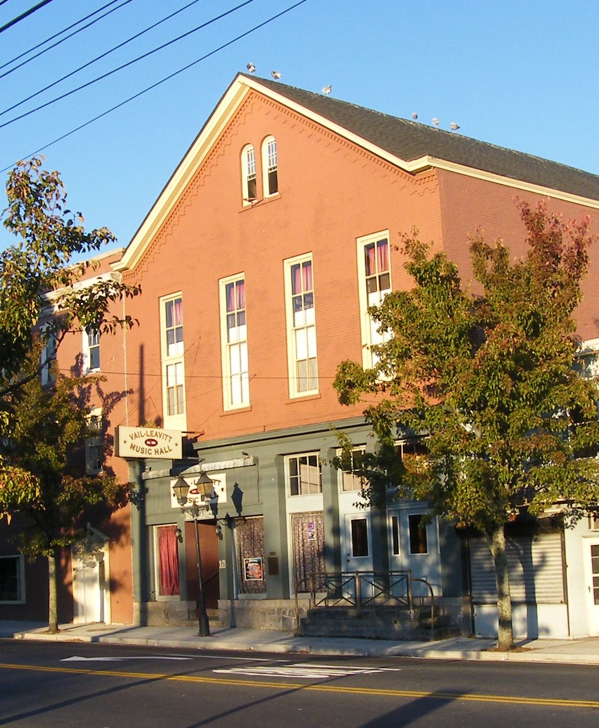
Vail-Leavitt Music Hall
Cinema and theater · National Register of Historic Places · 4.8 mi
Theater and former movie theater in Riverhead, New York, United States

Long Island Aquarium and Exhibition Center
Monument and historic site · 4.9 mi
Aquarium in Riverhead, New York, United States

Westhampton Beach Performng Arts Center
Cinema and theater · 2.7 mi
76 Main Street, Westhampton Beach
Museums and landmarks14

Big Duck
Monument and historic site · National Register of Historic Places · 4.6 mi
Historic commercial building in New York, United States

Big Duck Ranch
Monument and historic site · National Register of Historic Places · 4.6 mi
Building in New York, United States

Crowther House
Monument and historic site · National Register of Historic Places · 3.2 mi
Historic house in New York, United States

Foster-Meeker House
Monument and historic site · National Register of Historic Places · 2.5 mi
Historic house in New York, United States
Jagger House
Monument and historic site · National Register of Historic Places · 2.3 mi
Historic house in New York, United States

James Benjamin Homestead
Monument and historic site · National Register of Historic Places · 4.5 mi
Flanders, NY, listed on the NRHP in New York

Quogue Historic District
Monument and historic site · National Register of Historic Places · 4.2 mi
Historic district at the East End of Long Island, New York

Quogue Life-Saving Station
Monument and historic site · National Register of Historic Places · 4.2 mi
Historic building in Quogue, New York, United States
United States Post Office
Monument and historic site · National Register of Historic Places · 2.7 mi
Government building in Westhampton Beach, New York


United States Post Office
Monument and historic site · National Register of Historic Places · 4.9 mi
Government building in Riverhead, New York

2 more on the map.
Parks, trails and playgrounds12


Modern Yachts
Marina and boat launch · 3.2 mi
33 Library Avenue, Westhampton Beach

Westhampton Beach Marina
Marina and boat launch · 3.0 mi
1 Library Avenue, Westhampton Beach

Restaurants and cafes6




Where to stay3
Westhampton Seabreeze Motel
Motel and hotel · 2.1 mi
19 Seabreeze Avenue, Westhampton
Churches and places of worship8
Kingdom Hall of Jehovah’s Witnesses
Church · Jehovahs Witness · 2.9 mi
229 Old Country Road, Eastport
Beach United Methodist Church
Church · Methodist · 2.6 mi
39 Mill Road, Westhampton Beach
Saint Paul African Methodist Episcopal Zion Church
Church · African Methodist Episcopal Zion · 3.1 mi
39 Montauk Highway, Quogue
Westhampton Presbyterian Church
Church · 2.5 mi
90 Meeting House Road, Westhampton Beach
Gas and EV charging1
Schools, colleges and libraries19
Westhampton Beach Elementary School
School · 2.0 mi
379 Mill Rd, Westhampton Beach
Map of Westhampton
67 places. The map loads OpenStreetMap tiles when you open it.
Climate by month
Monthly table
| Month | High | Low | Rain |
|---|---|---|---|
| Jan | 39°F | 20°F | 3.2 in |
| Feb | 40°F | 21°F | 2.7 in |
| Mar | 47°F | 28°F | 4.3 in |
| Apr | 57°F | 36°F | 3.8 in |
| May | 66°F | 46°F | 3.3 in |
| Jun | 75°F | 56°F | 3.5 in |
| Jul | 81°F | 62°F | 2.9 in |
| Aug | 80°F | 61°F | 3.7 in |
| Sep | 74°F | 54°F | 3.8 in |
| Oct | 63°F | 42°F | 4.7 in |
| Nov | 53°F | 34°F | 3.5 in |
| Dec | 44°F | 26°F | 4.2 in |
U.S. Climate Normals 1991-2020 for Westhamptn Gabreski Ap (1 mi away), NOAA NCEI.
People and cost of living
American Community Survey 5-year estimates, 2020-2024, U.S. Census Bureau. Estimates have margins of error, larger for small towns.
Disaster history
Suffolk County has had 25 federal disaster declarations since 2000, most often for hurricanes.
- 2024-10-21: Severe Storm And Flooding (Severe Storm)
- 2024-08-25: Severe Storm And Flooding (Severe Storm)
- 2023-03-15: Severe Winter Storm And Snowstorm (Snowstorm)
- 2021-09-05: Remnants Of Hurricane Ida (Hurricane)
- 2021-09-02: Remnants Of Hurricane Ida (Hurricane)
- 2021-08-22: Hurricane Henri (Hurricane)
OpenFEMA disaster declarations summaries.
Getting there and nearby towns
Francis S. Gabreski Airport (FOK) is the nearest airport with scheduled flights listed in OpenStreetMap, 2 miles away.
- Remsenburg-Speonk 3 mi southwest, about 5 min by car
- Flanders 4 mi northeast, about 7 min by car
- Riverside 4 mi north, about 7 min by car
- Eastport 4 mi west, about 6 min by car
- East Quogue 5 mi east, about 7 min by car
- East Moriches 6 mi southwest, about 9 min by car
- Manorville 7 mi west, about 11 min by car
- Riverhead 7 mi north, about 12 min by car
- Hampton Bays 8 mi east, about 12 min by car
- Center Moriches 8 mi southwest, about 13 min by car
Drive times are estimates from straight-line distance, not routes.
Local news
Headlines from INDB, the NEMICO news database.
Reviews, tips and questions
Loading what members have shared...
Sources and licences
- NCES EDGE (Public domain): public schools
- NOAA NCEI U.S. Climate Normals 1991-2020 (Public domain): climate by month
- OpenFEMA (Public domain): disaster declarations
- OpenStreetMap contributors (ODbL 1.0): places, airports, map data
- U.S. Census Bureau (Public domain): population, income, housing, education, commute
- Wikidata (CC0 1.0): elevation, founding date, time zone, website, landmarks and historic places
- Wikimedia Commons (see each image): photos
- Wikipedia (CC BY-SA 4.0): overview and history text
Photo credits
- WesthamptonInnerWaterway, Peter Bond from Philadelphia, USA, CC BY-SA 2.0
- Cessna Citation Ultra (N560TA) in Westhampton Beach, NY, Quintin Soloviev, CC BY 4.0
- Foster Meeker House Westhampton Beach, NY, Dmadeo, CC BY-SA 3.0
- 2009 Westhampton Beach New York 3363332238 booktruck, Peter Dutton from Forest Hills, Queens, USA, CC BY 2.0
- Westhampton Beach 20180914 094636 01, CaptJayRuffins, CC BY-SA 4.0
- WesthamptonBeach 20180914 01, CaptJayRuffins, CC BY-SA 4.0
- USPO Westhampton Beach 20180914 (2), CaptJayRuffins, CC BY-SA 4.0
- USPO Westhampton Beach 20180914 (1), CaptJayRuffins, CC BY-SA 4.0
- Westhampton Beach Post Office, Dmadeo, CC BY-SA 3.0
- Riverhead-post-office, Americasroof, CC BY-SA 3.0
- Big Duck 2018 04, Photograph by Mike Peel ( www.mikepeel.net )., CC BY-SA 4.0
- Vail-leavitt, Americasroof, CC BY-SA 3.0
- Quogue Historical District NRHP 10, CaptJayRuffins, CC BY-SA 4.0
- Quogue Life-Saving Station, Quogue NY, Dmadeo, CC BY-SA 3.0
- Big Duck 2018 05, Photograph by Mike Peel ( www.mikepeel.net )., Public domain
- James Benjamin Homestead; Flanders, New York-2, DanTD, CC BY-SA 4.0
- Crowther House, Westhampton Beach, NY, Dmadeo, CC BY-SA 3.0
- Long Island Aquarium 2018 106, Photograph by Mike Peel ( www.mikepeel.net )., CC BY-SA 4.0
- New York National Guard (39516679231), The National Guard, CC BY 2.0
- Leia Eisenhower, Leisenhower, CC BY-SA 4.0
- Francis S. Gabreski Airport airport terminal & tower, Quintin Soloviev, CC BY 4.0
- 1987 Alfa Romeo Spider Quadrifoglio Verde (USA), rear left, Mr.choppers, CC BY-SA 3.0
- 1993 Porsche 968 Coupé (US, left rear), Mr.choppers, CC BY-SA 3.0
- 1980 Rolls-Royce Silver Shadow II, federal version (front right), Mr.choppers, CC BY-SA 3.0
- 1980 Rolls-Royce Silver Shadow II, federal version (rear right), Mr.choppers, CC BY-SA 3.0
- 1985 BMW 316 Baur TC2 (front right), Mr.choppers, CC BY-SA 3.0
- 1987 Peugeot 505 Turbo S, left rear (US), Mr.choppers, CC BY-SA 3.0
- 1993 Porsche 968 Cabriolet, front right, Mr.choppers, CC BY-SA 3.0
- 1985 BMW 316 Baur TC2 (rear left), Mr.choppers, CC BY-SA 3.0
- 1993 Porsche 968 Cabriolet, rear left, Mr.choppers, CC BY-SA 3.0
- 1987 Peugeot 505 Turbo S, left front (US), Mr.choppers, CC BY-SA 3.0
- East End Hospice - panoramio, dans362, CC BY 3.0
- Quiogue, NY 11978, USA - panoramio, dans362, CC BY 3.0
- Quiogue, NY 11978, USA - panoramio (1), dans362, CC BY 3.0
- Jagger Grave, Muncharelli, CC BY-SA 4.0
- Shingle Style Quiogue home 20180914, CaptJayRuffins, CC BY-SA 4.0
- Atlantic White Cypress, East Quogue, Long Island, New York 1, msirotkin, CC BY 4.0
- Atlantic White Cypress, East Quogue, Long Island, New York 2, msirotkin, CC BY 4.0
- Eastern Screech Owl, Wolfgang Wander, CC BY-SA 3.0
- Flickr - DVIDSHUB - Holiday Events (Image 5 of 7), DVIDSHUB, Public domain


Page built October 30, 2026. Spotted a mistake? Tell us or suggest a place.