




Argyle, Texas
Argyle is a city of 5,371 people in Denton County, Texas, founded in 1881.
Why visit Argyle
Townapedia lists 5 museums and landmarks, 7 parks and trails, 12 places to eat and 2 attractions in and around town.
Highlights include Long Point, Old Alton Bridge and Patrick Park.
July is the warmest month, with average highs of 96°F; January lows average 32°F.
Weather in Argyle
Forecast from the National Weather Service. Full forecast
About Argyle
Argyle is a city in Denton County, Texas, United States, with a population of 5,503 as of 2022. It is a suburb of Fort Worth.
From the Wikipedia article Argyle, Texas (this version), under CC BY-SA 4.0.
Things to do2

Museums and landmarks5
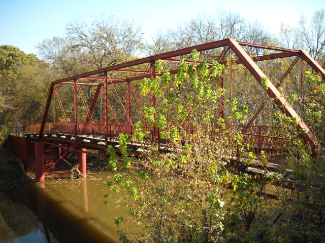
Old Alton Bridge
Bridge · National Register of Historic Places · 4.6 mi
Bridge in Denton County, Texas, United States

Parks, trails and playgrounds7

Patrick Park
Park · 2.2 mi
6500 Ridglea Court, Denton
Mo-Su 06:00-22:00

Restaurants and cafes12

Marty B's
Restaurant · Regional, Barbecue · 2.8 mi
2664 FM 407, Bartonville
Su 11:00-21:00, Mo-Th 11:00-22:00, Fr-Sa 11:00-23:00

Marty B's Coffee
Cafe · Coffee Shop · 2.8 mi
2656 FM 407, Bartonville
Su 07:00-17:00, Mo-Th 06:00-21:00, Fr-Sa 06:00-22:00

Farmhouse Coffee and Treasures
Cafe · Coffee Shop · 3.1 mi
1300 Homestead Way, Argyle
Tu-Fr 06:00-18:00, Sa-Su 07:00-18:00, Mo 06:00-12:00

History
The first European settlement, consisting of a few families, occurred in the Argyle area in the 1850s. The place was then known as Pilot Knob or Waintown. The settlement gradually acquired a few amenities in the late 1800s - a school in 1875, a Baptist church in 1876, and a post office in 1878. The community was formally founded and renamed Argyle in 1881, after the Texas and Pacific Railroad built a track through the area. Some believe a railroad surveyor named the town after a garden in France, but others believe the town to be named after the region of Argyll in Scotland. Also around this time, Sam Bass, an infamous outlaw who stole $60,000 in gold coins from the Union Pacific Railroad, was rumored to have stashed the gold in a cave. Sam Bass died when he was 27, and it was rumored he never lived to retrieve the gold.
From the History section of Argyle, Texas on Wikipedia, under CC BY-SA 4.0.
Churches and places of worship7
Kingdom Hall of Jehovah's Witnesses
Church · Jehovahs Witness · 1.9 mi
1150 North US Highway 377, Argyle
Shopping1
Schools, colleges and libraries31
Founders Classical Academy of Flower Mound
School · 5.8 mi
4901 Cross Timbers Rd, Flower Mound
Healthcare1
Map of Argyle
66 places. The map loads OpenStreetMap tiles when you open it.
Climate by month
Monthly table
| Month | High | Low | Rain |
|---|---|---|---|
| Jan | 56°F | 32°F | 1.9 in |
| Feb | 60°F | 36°F | 2.5 in |
| Mar | 68°F | 45°F | 3.1 in |
| Apr | 75°F | 51°F | 3.4 in |
| May | 83°F | 61°F | 4.5 in |
| Jun | 91°F | 69°F | 3.7 in |
| Jul | 96°F | 73°F | 1.8 in |
| Aug | 96°F | 72°F | 2.4 in |
| Sep | 88°F | 64°F | 2.6 in |
| Oct | 78°F | 53°F | 4.2 in |
| Nov | 66°F | 42°F | 2.7 in |
| Dec | 57°F | 34°F | 2.8 in |
U.S. Climate Normals 1991-2020 for Denton Muni Ap (7 mi away), NOAA NCEI.
People and cost of living
American Community Survey 5-year estimates, 2020-2024, U.S. Census Bureau. Estimates have margins of error, larger for small towns.
Disaster history
Denton County has had 17 federal disaster declarations since 2000, most often for hurricanes.
- 2024-05-17: Severe Storms, Straight-Line Winds, Tornadoes, And Flooding (Flood)
- 2021-02-19: Severe Winter Storms (Severe Ice Storm)
- 2021-02-14: Severe Winter Storm (Severe Ice Storm)
- 2020-03-25: Covid-19 Pandemic (Biological)
- 2020-03-13: Covid-19 (Biological)
- 2015-05-29: Severe Storms, Tornadoes, Straight-Line Winds And Flooding (Severe Storm)
OpenFEMA disaster declarations summaries.
Getting there and nearby towns
Fort Worth Alliance Airport (AFW) is the nearest airport with scheduled flights listed in OpenStreetMap, 11 miles away.
- Bartonville 2 mi southeast, about 3 min by car
- Lantana 3 mi east, about 6 min by car
- Copper Canyon 5 mi east, about 8 min by car
- Double Oak 5 mi southeast, about 8 min by car
- Flower Mound 6 mi southeast, about 10 min by car
- Corinth 7 mi northeast, about 11 min by car
- Highland Village 7 mi east, about 11 min by car
- Roanoke 7 mi southwest, about 11 min by car
- Denton 8 mi north, about 13 min by car
- Trophy Club 8 mi south, about 13 min by car
Drive times are estimates from straight-line distance, not routes.
Local news
Headlines from INDB, the NEMICO news database.
Reviews, tips and questions
Loading what members have shared...
Sources and licences
- NCES EDGE (Public domain): public schools
- NOAA NCEI U.S. Climate Normals 1991-2020 (Public domain): climate by month
- OpenFEMA (Public domain): disaster declarations
- OpenStreetMap contributors (ODbL 1.0): places, airports, map data
- U.S. Census Bureau (Public domain): population, income, housing, education, commute
- Wikidata (CC0 1.0): elevation, founding date, time zone, website, landmarks and historic places
- Wikimedia Commons (see each image): photos
- Wikipedia (CC BY-SA 4.0): overview and history text
Photo credits
- Argyle Town Hall, Renelibrary, CC BY-SA 3.0
- Old Alton Bridge, Ron from Denton, Texas, CC BY 2.0
- ISS022-E-53073 - View of Earth, Earth Science and Remote Sensing Unit , Lyndon B. Johnson Space Center, Public domain
- ISS055-E-27364 - View of Texas, Earth Science and Remote Sensing Unit, NASA Johnson Space Center, Public domain
- ISS032-E-27878 - View of Earth, Earth Science and Remote Sensing Unit , Lyndon B. Johnson Space Center, Public domain
- ISS018-E-45054 - View of Texas, Earth Science and Remote Sensing Unit , Lyndon B. Johnson Space Center, Public domain
- ISS055-E-27363 - View of Texas, Earth Science and Remote Sensing Unit, NASA Johnson Space Center, Public domain
- ISS018-E-24065 - View of Earth, Earth Science and Remote Sensing Unit , Lyndon B. Johnson Space Center, Public domain


Page built October 30, 2026. Spotted a mistake? Tell us or suggest a place.