


Blue Mound, Texas
Blue Mound is a city of 2,366 people in Tarrant County, Texas, founded in 1957.
Why visit Blue Mound
Townapedia lists 1 museum or landmark, 3 parks and trails, 37 places to eat, 7 places to stay and 1 attraction in and around town.
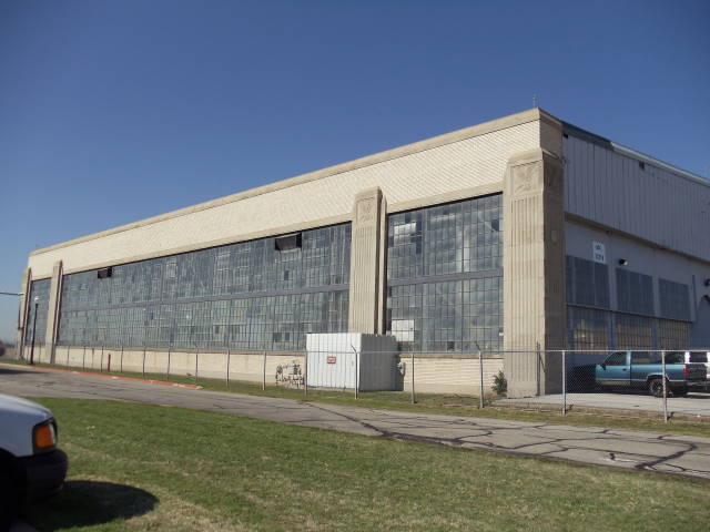
Highlights include Regal Fossil Creek and American Airways Hangar and Administration Building.
August is the warmest month, with average highs of 97°F; January lows average 37°F.
Weather in Blue Mound
Forecast from the National Weather Service. Full forecast
About Blue Mound
Blue Mound is a city in Tarrant County, Texas, United States. The population was 2,393 as of the 2020 census.
From the Wikipedia article Blue Mound, Texas (this version), under CC BY-SA 4.0.
Things to do1

Museums and landmarks1
American Airways Hangar and Administration Building
Monument and historic site · National Register of Historic Places · 2.5 mi
Building in Fort Worth (vicinity), Tarrant County, Texas
Parks, trails and playgrounds3



Restaurants and cafes37


Swig Drinks
Cafe · Soda · 1.0 mi
7004 North Blue Mound Road, Fort Worth
Mo-Th 08:00-21:00; Fr 08:00-22:00; Sa 09:00-22:00; Su 09:30-21:00

Fred's North
Restaurant · Burger · 1.1 mi
2740 Western Center Boulevard, Fort Worth
Mo-We 10:30-22:00; Th-Su 10:30-24:00
Bosses Pizza and Pasta
Restaurant · Italian, Pizza · 1.2 mi
2740 Western Center Boulevard
11:00-21:00; Fr,Sa 11:00-22:00
DV's Homemade Donuts
Cafe · 0.4 mi
330 South Blue Mound Road, Saginaw
Mo-Su 04:30-12:00
Simply Gyros
Restaurant · Turkish · 1.5 mi
6600 North Freeway, Fort Worth
Mo-Sa 11:00-21:00
25 more on the map.
History
The community's history dates back to the 1920s, when Scottish immigrant John Kennedy established Globe Laboratories, Inc. to produce serum to immunize cattle against blackleg, a disease that affected calves under two years of age. About ten years later, he sold the company to his partner. Kennedy later purchased 400 acres (1.6 km2) of land in an area bordered by East McLeroy Boulevard on the north and FM 156 (Blue Mound Road) to the east. His interest in aircraft led him to create the Globe Aircraft Company. As his operation grew, more and more people began to settle near his plant. The settlement was initially known as Saginaw Park, but later took the name Blue Mound after a nearby hill. During the 1950s, Bell Helicopter used Kennedy's facility to develop its new helicopters, but the company left the facility in 1960. Blue Mound incorporated in 1957 and had a population of 1,253 by the 1960 census. That figure had risen to 1,283 by 1970 and 2,169 in 1980 as the city became a bedroom community for those employed in Fort Worth and the surrounding area. The 1990 census showed a slight decline in population, to 2,133. By 2000, the number of inhabitants had risen to 2,388.
From the History section of Blue Mound, Texas on Wikipedia, under CC BY-SA 4.0.
Where to stay7
Sleep Inn & Suites Fort Worth - Fossil Creek
Motel and hotel · 1.4 mi
6050 Old Denton Road, Fort Worth
Holiday Inn Express & Suites
Motel and hotel · 1.4 mi
6351 North Freeway, Fort Worth
Churches and places of worship5
North Fort Worth Baptist Church
Church · Baptist · 1.4 mi
5801 North Freeway, Fort Worth
Shopping2
Gas and EV charging7
Schools, colleges and libraries44
Healthcare3
Map of Blue Mound
110 places. The map loads OpenStreetMap tiles when you open it.
Climate by month
Monthly table
| Month | High | Low | Rain |
|---|---|---|---|
| Jan | 59°F | 37°F | 2.2 in |
| Feb | 64°F | 40°F | 2.5 in |
| Mar | 71°F | 48°F | 3.4 in |
| Apr | 78°F | 56°F | 3.3 in |
| May | 86°F | 63°F | 4.7 in |
| Jun | 93°F | 72°F | 3.9 in |
| Jul | 97°F | 76°F | 2.5 in |
| Aug | 97°F | 76°F | 2.7 in |
| Sep | 89°F | 68°F | 3.0 in |
| Oct | 80°F | 58°F | 4.5 in |
| Nov | 68°F | 47°F | 2.7 in |
| Dec | 59°F | 39°F | 2.5 in |
U.S. Climate Normals 1991-2020 for Ft Worth Meacham Fld Naaf 74739 (3 mi away), rain and snow from Saginaw 1.0 Ssw, NOAA NCEI.
People and cost of living
American Community Survey 5-year estimates, 2020-2024, U.S. Census Bureau. Estimates have margins of error, larger for small towns.
Disaster history
Tarrant County has had 19 federal disaster declarations since 2000, most often for hurricanes.
- 2021-02-19: Severe Winter Storms (Severe Ice Storm)
- 2021-02-14: Severe Winter Storm (Severe Ice Storm)
- 2020-08-24: Tropical Storms Marco And Laura (Hurricane)
- 2020-03-25: Covid-19 Pandemic (Biological)
- 2020-03-13: Covid-19 (Biological)
- 2017-08-25: Hurricane Harvey (Hurricane)
OpenFEMA disaster declarations summaries.
Getting there and nearby towns
Fort Worth Meacham International Airport (FTW) is the nearest airport with scheduled flights listed in OpenStreetMap, 2 miles away.
- Saginaw 2 mi northwest, about 3 min by car
- Fort Worth 5 mi south, about 8 min by car
- Haltom City 5 mi southeast, about 7 min by car
- Watauga 5 mi east, about 8 min by car
- North Richland Hills 7 mi east, about 11 min by car
- Keller 9 mi northeast, about 14 min by car
- Hurst 9 mi east, about 15 min by car
- White Settlement 10 mi southwest, about 16 min by car
- Colleyville 11 mi east, about 18 min by car
- Bedford 12 mi east, about 19 min by car
Drive times are estimates from straight-line distance, not routes.
Local news
Headlines from INDB, the NEMICO news database.
Reviews, tips and questions
Loading what members have shared...
Sources and licences
- NCES EDGE (Public domain): public schools
- NOAA NCEI U.S. Climate Normals 1991-2020 (Public domain): climate by month
- OpenFEMA (Public domain): disaster declarations
- OpenStreetMap contributors (ODbL 1.0): places, airports, map data
- U.S. Census Bureau (Public domain): population, income, housing, education, commute
- Wikidata (CC0 1.0): elevation, founding date, time zone, website, landmarks and historic places
- Wikimedia Commons (see each image): photos
- Wikipedia (CC BY-SA 4.0): overview and history text
Photo credits
- American Airlines Hangar Fort Worth, Renelibrary, CC BY-SA 3.0
- 19971017 01 BNSF Headquarters, Ft. Worth, Texas (6141625761), David Wilson from Oak Park, Illinois, USA, CC BY 2.0
- Pallet Wall, Yourusernamewillbepublic2, CC0
- Saginaw, Texas (48925915842), Nicolas Henderson from Coppell, Texas, CC BY 2.0
- Train Depot, Saginaw, Texas, Nicolas Henderson, CC BY 2.0
- Train Depot, Saginaw, Texas (48925720136), Nicolas Henderson from Coppell, Texas, CC BY 2.0
- Train Depot, Saginaw, Texas (48925184003), Nicolas Henderson from Coppell, Texas, CC BY 2.0
- Saginaw, Texas (48925916222), Nicolas Henderson from Coppell, Texas, CC BY 2.0
- Saginaw, Texas (48925914732), Nicolas Henderson from Coppell, Texas, CC BY 2.0


Page built October 30, 2026. Spotted a mistake? Tell us or suggest a place.