


Brackenridge, Pennsylvania
Brackenridge is a borough of 3,167 people in Allegheny County, Pennsylvania, founded in September 21, 1901.
Why visit Brackenridge
Townapedia lists 13 museums and landmarks, 6 parks and trails, 27 places to eat, 1 place to stay and 1 attraction in and around town.
Highlights include George D. Stuart Bridge, Allegheny River Lock and Dam No. 4 and Burtner House.
July is the warmest month, with average highs of 83°F; January lows average 20°F.
Weather in Brackenridge
Forecast from the National Weather Service. Full forecast
About Brackenridge
Brackenridge is a borough in Allegheny County, Pennsylvania, United States, located along the Allegheny River. It is part of the Greater Pittsburgh metropolitan area.
From the Wikipedia article Brackenridge, Pennsylvania (this version), under CC BY-SA 4.0.
Things to do1

George D. Stuart Bridge
Bridge · 1.1 mi
Bridge over the Allegheny River in Pennsylvania
Museums and landmarks13
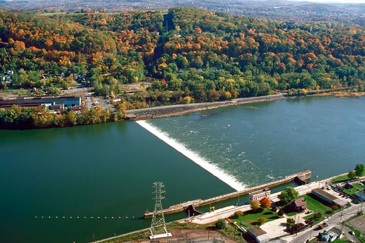
Allegheny River Lock and Dam No. 4
Monument and historic site · National Register of Historic Places · 1.3 mi
Gravity dam and lock in Harrison Township, Pennsylvania

Burtner House
Monument and historic site · National Register of Historic Places · 1.7 mi
Historic house in Pennsylvania, United States


New Kensington Downtown Historic District
Monument and historic site · National Register of Historic Places · 3.2 mi
Historic district in New Kensington, Pennsylvania
New Kensington Production Works Historic District
Monument and historic site · National Register of Historic Places · 3.3 mi
Historic district in Pennsylvania, United States
Pennsalt Historic District
Monument and historic site · National Register of Historic Places · 1.1 mi
Historic district in Pennsylvania, United States
Esplanade
Monument and historic site · 1.2 mi
The esplanade consists of concrete-paved fill between the former river bank and the lock's land wall.
Lock No. 4
Monument and historic site · 1.2 mi
The lock, 56 by 360 feet, has a lift of 10.6 feet, from 734.8 to 745.4 feet. The sidewalls are steel-armored concrete, and mooring pins...
1 more on the map.
Parks, trails and playgrounds6



Restaurants and cafes27


Villa Ballanca
Restaurant · Italian · 1.2 mi
2740 Leechburg Road, Lower Burrell
We-Sa 11:00-21:00; Su 11:00-20:00
Maddio's Pizza and Subs
Restaurant · Pizza, Sandwich · 0.4 mi
1000 Broadview Boulevard, Brackenridge
Mo-We 11:00-21:00, Th-Sa 11:00-23:00; Su 12:00-21:00


15 more on the map.
Where to stay1
Churches and places of worship18
Mount St. Peter Church
Church · National Register of Historic Places · 3.3 mi
Faith Lutheran Church
Church · Lutheran · 0.9 mi
1500 Broadview Boulevard, Natrona Heights
Shopping5
Gas and EV charging6
Schools, colleges and libraries27
Healthcare2
Map of Brackenridge
106 places. The map loads OpenStreetMap tiles when you open it.
Climate by month
Monthly table
| Month | High | Low | Rain |
|---|---|---|---|
| Jan | 36°F | 20°F | 3.1 in |
| Feb | 40°F | 21°F | 2.8 in |
| Mar | 50°F | 27°F | 3.3 in |
| Apr | 62°F | 38°F | 3.6 in |
| May | 72°F | 50°F | 3.9 in |
| Jun | 80°F | 59°F | 4.3 in |
| Jul | 83°F | 63°F | 4.3 in |
| Aug | 82°F | 62°F | 3.5 in |
| Sep | 76°F | 55°F | 4.0 in |
| Oct | 64°F | 43°F | 3.1 in |
| Nov | 52°F | 33°F | 3.1 in |
| Dec | 41°F | 26°F | 3.3 in |
U.S. Climate Normals 1991-2020 for Natrona Lock 4 (1 mi away), NOAA NCEI.
People and cost of living
American Community Survey 5-year estimates, 2020-2024, U.S. Census Bureau. Estimates have margins of error, larger for small towns.
Disaster history
Allegheny County has had 8 federal disaster declarations since 2000, most often for hurricanes.
- 2020-03-30: Covid-19 Pandemic (Biological)
- 2020-03-13: Covid-19 (Biological)
- 2013-10-01: Severe Storms, Tornadoes, And Flooding (Severe Storm)
- 2012-10-29: Hurricane Sandy (Hurricane)
- 2010-04-16: Severe Winter Storms And Snowstorms (Snowstorm)
- 2005-09-10: Hurricane Katrina (Hurricane)
OpenFEMA disaster declarations summaries.
Getting there and nearby towns
Pittsburgh-Butler Regional Airport (BTP) is the nearest airport with scheduled flights listed in OpenStreetMap, 16 miles away.
- Lower Burrell 2 mi southeast, about 3 min by car
- Arnold 2 mi southwest, about 4 min by car
- New Kensington 3 mi south, about 4 min by car
- Russellton 5 mi west, about 8 min by car
- Cheswick 6 mi southwest, about 9 min by car
- Freeport 6 mi northeast, about 10 min by car
- Plum 7 mi south, about 12 min by car
- West Leechburg 7 mi east, about 11 min by car
- Apollo 9 mi east, about 15 min by car
- North Apollo 10 mi east, about 16 min by car
Drive times are estimates from straight-line distance, not routes.
Local news
Headlines from INDB, the NEMICO news database.
Reviews, tips and questions
Loading what members have shared...
Sources and licences
- NCES EDGE (Public domain): public schools
- NOAA NCEI U.S. Climate Normals 1991-2020 (Public domain): climate by month
- OpenFEMA (Public domain): disaster declarations
- OpenStreetMap contributors (ODbL 1.0): places, airports, map data
- U.S. Census Bureau (Public domain): population, income, housing, education, commute
- Wikidata (CC0 1.0): elevation, founding date, time zone, website, landmarks and historic places
- Wikimedia Commons (see each image): photos
- Wikipedia (CC BY-SA 4.0): overview and history text
Photo credits
- Allegheny Ludlum Brackenridge Works, takomabibelot Camera location 40° 36′ 31.32″ N, 79° 44′ 07.9″ W View this and other nearby images on: OpenStreetMap 40.608699; -79.735529, CC BY 2.0
- Price & Sims Number Two Cast Iron Door (Brackenridge, PA) (2167997741), takomabibelot, CC BY 2.0
- "No. 66 Cap 10 Ton Aux. 25 Ton Main" at the Allegheny Ludlum Brackenridge Works (Brackenridge, PA) (3564593379), takomabibelot, CC BY 2.0
- Not (Brackenridge, PA) (5307850471), takomabibelot, CC BY 2.0
- Mile Lock Lane & Allegheny Ludlum Brackenridge Works (Brackenridge, PA) (3564616781), takomabibelot, CC BY 2.0
- "Watch Your Step" at the Allegheny Ludlum Brackenridge Works (Brackenridge, PA) (3564604201), takomabibelot, CC BY 2.0
- "We Will Remember Vietnam" Memorial Dedicated in Brackenridge Park, May 7, 1975 (Brackenridge, PA) (408769167), takomabibelot, CC0
- Allegheny River Lock and Dam No.4, U.S. Army Corps of Engineers, Public domain
- Mount Saint Peter Church, Rudy4rachel ( talk ), Public domain
- Liberty Theater, New Kensington, Fred S. Danner, Public domain
- Tarentumbridge, Mr. Vitale ( talk ), Public domain
- Pizza Now (Tarentum, PA) (4257502127), takomabibelot from Austin TX, USA, CC BY 2.0
- Towboat "Annette G" Pushing A Dredger Crane Barge Above The George D. Stuart Bridge (Tarentum, PA), takomabibelot, CC BY 2.0
- Rolling Crucibles (Natrona, PA) (4790018972), takomabibelot, CC BY 2.0
- High Water Below Lock & Dam 4 (Natrona, PA) (3178843051), takomabibelot, CC BY 2.0
- B (Natrona Heights, PA) (5291024268) (adapted), takomabibelot, CC BY 2.0
- J (Natrona Heights, PA) (5290419405), takomabibelot, CC BY 2.0
- Ampersand (Natrona Heights, PA) (5290420451), takomabibelot, CC BY 2.0
- B (Natrona Heights, PA) (5291024268), takomabibelot, CC BY 2.0
- Steel Mill in the Sun (Natrona, PA) (4234906329), takomabibelot, CC BY 2.0


Page built October 30, 2026. Spotted a mistake? Tell us or suggest a place.