


Clinton, Massachusetts
Clinton is a community of 7,658 people in Worcester County, Massachusetts.
Why visit Clinton
Townapedia lists 24 museums and landmarks, 14 parks and trails, 12 places to eat, 1 place to stay and 5 attractions in and around town.
Highlights include Atherton Bridge, The Strand Theatre, Wachusett Dam and Anthony Lane House.
July is the warmest month, with average highs of 83°F; January lows average 16°F.
Weather in Clinton
Forecast from the National Weather Service. Full forecast
About Clinton
Clinton is a census-designated place (CDP) in the town of Clinton in Worcester County, Massachusetts, United States. The population was 7,389 at the 2010 census.
From the Wikipedia article Clinton (CDP), Massachusetts (this version), under CC BY-SA 4.0.
Things to do5

Atherton Bridge
Bridge · National Register of Historic Places · 1.9 mi
Bridge in United States of America


Museums and landmarks24

Wachusett Dam
Monument and historic site · National Register of Historic Places · 1.1 mi
Dam in Clinton, Massachusetts, USA

Anthony Lane House
Monument and historic site · National Register of Historic Places · 3.3 mi
House in Lancaster, Massachusetts
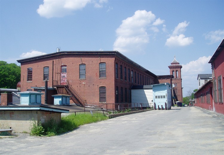
Bigelow Carpet Company Woolen Mills
Monument and historic site · National Register of Historic Places
Factory in Massachusetts, United States of America

Bowers School
Monument and historic site · National Register of Historic Places · 0.7 mi
Historic school building in Clinton, Massachusetts, United States

Center Village District
Monument and historic site · National Register of Historic Places · 2.7 mi
Historic district in Massachusetts, United States

Corcoran School
Monument and historic site · National Register of Historic Places
Historic school building in Clinton, Massachusetts, United States

Downtown Clinton Historic District
Monument and historic site · National Register of Historic Places
Historic district in Massachusetts, United States

Founder's Hall
Monument and historic site · National Register of Historic Places · 1.8 mi
Historic building in Lancaster, Massachusetts

Lancaster Industrial School for Girls
Monument and historic site · National Register of Historic Places · 2.2 mi
Girl school in Massachusetts, United States of America


Lancaster Mills
Monument and historic site · National Register of Historic Places · 0.6 mi
Historic district in Clinton, United States of America
Middle Cemetery
Monument and historic site · National Register of Historic Places · 2.1 mi
Cemetery in Lancaster, Worcester County, Massachusetts, United States
Nathaniel Thayer Estate
Monument and historic site · National Register of Historic Places · 2.1 mi
Lancaster, Massachusetts, listed on the NRHP in Worcester County
12 more on the map.
Parks, trails and playgrounds14


2 more on the map.
Restaurants and cafes12

Michael's Bridge Diner
Restaurant · 1.3 mi
56 South Main Street
Mo-Sa 06:00-15:00; Tu off; Su 06:00-14:00
John's Sandwich Shop
Restaurant · Sandwich
727 Main Street, Clinton
T.C. Landos
Restaurant · American, Pizza, Salad, Sandwich · 0.4 mi
Mo-Sa 11:00-21:00; Su 12:00-20:00
Zaytoon Clinton
Restaurant · Mediterranean
72B High Street, Clinton




McDonald's
Fast food · Burger · 0.9 mi
1040 Main Street, Clinton
Mo-Th 05:30-24:00; Fr 05:30-04:00, Sa 00:00-24:00, Su 04:00-24:00
Where to stay1
Churches and places of worship11
First Church of Christ, Unitarian
Church · National Register of Historic Places · 2.6 mi
First Methodist Church
Church · National Register of Historic Places
Shopping6
Gas and EV charging2
Schools, colleges and libraries16
Healthcare3
Map of Clinton
94 places. The map loads OpenStreetMap tiles when you open it.
Climate by month
Monthly table
| Month | High | Low | Rain |
|---|---|---|---|
| Jan | 34°F | 16°F | 2.6 in |
| Feb | 37°F | 17°F | 2.8 in |
| Mar | 45°F | 25°F | 3.8 in |
| Apr | 58°F | 35°F | 3.8 in |
| May | 70°F | 46°F | 3.6 in |
| Jun | 78°F | 56°F | 4.1 in |
| Jul | 83°F | 62°F | 3.5 in |
| Aug | 82°F | 60°F | 3.4 in |
| Sep | 74°F | 51°F | 4.0 in |
| Oct | 62°F | 40°F | 4.5 in |
| Nov | 50°F | 30°F | 3.6 in |
| Dec | 40°F | 22°F | 3.7 in |
U.S. Climate Normals 1991-2020 for Fitchburg Muni Ap (10 mi away), NOAA NCEI.
People and cost of living
American Community Survey 5-year estimates, 2020-2024, U.S. Census Bureau. Estimates have margins of error, larger for small towns.
Disaster history
Worcester County has had 24 federal disaster declarations since 2000, most often for severe storms.
- 2024-05-15: Severe Storms And Flooding (Flood)
- 2023-09-15: Hurricane Lee (Hurricane)
- 2020-03-27: Covid-19 Pandemic (Biological)
- 2020-03-13: Covid-19 (Biological)
- 2018-07-19: Severe Winter Storm And Snowstorm (Snowstorm)
- 2015-04-13: Severe Winter Storm, Snowstorm, And Flooding (Severe Storm)
OpenFEMA disaster declarations summaries.
Getting there and nearby towns
Minute Man Airfield (MMN) is the nearest airport with scheduled flights listed in OpenStreetMap, 9 miles away.
- South Lancaster 1 mi northwest, about 2 min by car
- Hudson 6 mi east, about 10 min by car
- Leominster 8 mi northwest, about 13 min by car
- Shirley 8 mi north, about 13 min by car
- Marlborough 9 mi southeast, about 14 min by car
- Devens 9 mi northeast, about 15 min by car
- Ayer 11 mi northeast, about 18 min by car
- Worcester 12 mi southwest, about 19 min by car
- Maynard 12 mi east, about 19 min by car
- Fitchburg 14 mi northwest, about 23 min by car
Drive times are estimates from straight-line distance, not routes.
Local news
Headlines from INDB, the NEMICO news database.
Reviews, tips and questions
Loading what members have shared...
Sources and licences
- NCES EDGE (Public domain): public schools
- NOAA NCEI U.S. Climate Normals 1991-2020 (Public domain): climate by month
- OpenFEMA (Public domain): disaster declarations
- OpenStreetMap contributors (ODbL 1.0): places, airports, map data
- U.S. Census Bureau (Public domain): population, income, housing, education, commute
- Wikidata (CC0 1.0): elevation, founding date, time zone, website, landmarks and historic places
- Wikimedia Commons (see each image): photos
- Wikipedia (CC BY-SA 4.0): overview and history text
Photo credits
- Strand Theatre, Clinton MA, John Phelan, CC BY-SA 3.0
- Arch bridge over Main Street, Clinton, Massachusetts, March 2022, Pi.1415926535, CC BY-SA 4.0
- Clinton station outside stairs to upper level, January 2016, Pi.1415926535, CC BY-SA 3.0
- Clinton station upper level platform area, January 2016, Pi.1415926535, CC BY-SA 3.0
- Freight train in Clinton, May 2017, Pi.1415926535, CC BY-SA 3.0
- Former steps to upper platform at Clinton station, May 2017, Pi.1415926535, CC BY-SA 3.0
- Clinton station from parking lot, January 2016, Pi.1415926535, CC BY-SA 3.0
- Clinton station HDR, May 2017, Pi.1415926535, CC BY-SA 3.0
- Former baggage room in Clinton station, May 2017, Pi.1415926535, CC BY-SA 3.0
- Streetcar on High Street, Clinton, circa 1908, Unknown author Unknown author, Public domain
- Archway in former Clinton station, May 2017, Pi.1415926535, CC BY-SA 3.0
- Regonini Memorials at Clinton station, January 2016, Pi.1415926535, CC BY-SA 3.0
- Industrial building with freight track cutout in Clinton, May 2017, Pi.1415926535, CC BY-SA 3.0
- Old union station in Clinton (2) - postcard, Unknown author Unknown author, Public domain
- Old union station in Clinton (1) - postcard, Unknown author Unknown author, Public domain
- Clinton station from Agricultural Branch tracks, January 2016, Pi.1415926535, CC BY-SA 3.0
- Clinton station and Worcester Branch tracks, May 2017, Pi.1415926535, CC BY-SA 3.0
- Postcard of streetcar on High Street, Clinton, Unknown author Unknown author, Public domain
- First Methodist Church Clinton Massachusetts, Tim Pierce, CC BY-SA 3.0
- High Street, Clinton, Massachusetts June 2026, 4300streetcar, CC BY 4.0
- Arch bridge over Greeley Street, Clinton, Massachusetts, March 2022, Pi.1415926535, CC BY-SA 4.0
- Abandoned Train Tunnel, Clinton, United States (Unsplash), Candice Seplow csgraphicdesign, CC0
- Mass Central Rail Trail cut, Clinton MA, John Phelan, CC BY 4.0
- Wachusett-dam, Martinde at en.wikipedia, CC BY-SA 3.0
- Second Meeting House of the United Methodists, Clinton MA, John Phelan, CC BY-SA 3.0
- SterlingMA StephenHastingsHouse, User:Magicpiano, CC BY-SA 4.0
- Lancaster Mills Clinton Mass, Marcbela (Marc N. Belanger), Public domain
- Lancaster Unitarian Church, Lancaster, MA, Paul Keleher, CC BY 2.0
- Bowers School Clinton MA, Tim Pierce, CC BY 3.0
- Atlantic Union College - Founder's Hall, Daderot, Public domain
- Atherton Bridge, Jet Lowe, Public domain
- LancasterMA OldSettlersBuryingGround, Magicpiano, CC BY-SA 4.0
- SouthboroughMA WachusettAqueductLowerDam, User:Magicpiano, CC BY-SA 4.0
- Bigelow Carpet Mills Clinton, Marcbela (Marc N. Belanger), Public domain
- LancasterMA GirlsSchool 1, User:Magicpiano, CC BY-SA 4.0
- First Church of Christ,Lancaster MA, John Phelan, CC BY 3.0
- ClintonMA WoodlawnCemetery Gate, User:Magicpiano, CC BY-SA 4.0
- High-Union Clinton MA, Marcbela (Marc N. Belanger), Public domain
- South Lancaster Engine House, South Lancaster MA, John Phelan, CC BY 3.0
- Corcoran School Clinton MA, Tim Pierce, CC BY 3.0


Page built October 30, 2026. Spotted a mistake? Tell us or suggest a place.