


Marlborough, Massachusetts
Marlborough is a city of 41,647 people in Middlesex County, Massachusetts, founded in 1657.
Why visit Marlborough
Townapedia lists 40 museums and landmarks, 107 parks and trails, 103 places to eat, 12 places to stay and 32 attractions in and around town.
Highlights include Taylor Memorial Bridge, Jericho Hill, Berlin Town Hall and Brigham Cemetery.
July is the warmest month, with average highs of 87°F; January lows average 15°F.
Weather in Marlborough
Forecast from the National Weather Service. Full forecast
About Marlborough
Marlborough is a city in Middlesex County, Massachusetts, United States. The population was 41,793 at the 2020 census. Marlborough became a prosperous industrial town in the 19th century and made the transition to high technology industry in the late 20th century after the construction of the Massachusetts Turnpike. It is part of the Worcester metropolitan area.
From the Wikipedia article Marlborough, Massachusetts (this version), under CC BY-SA 4.0.
Things to do32

Taylor Memorial Bridge
Bridge · 2.9 mi
Pedestrian bridge in Hudson, Massachusetts

20 more on the map.
Museums and landmarks40

Berlin Town Hall
Monument and historic site · National Register of Historic Places · 5.1 mi
Town hall in Berlin, Massachusetts, United States
Brigham Cemetery
Monument and historic site · National Register of Historic Places · 0.8 mi
Historic cemetery in Marlborough, Massachusetts, United States
Bullard House
Monument and historic site · National Register of Historic Places · 5.1 mi
Historic house in Massachusetts, United States
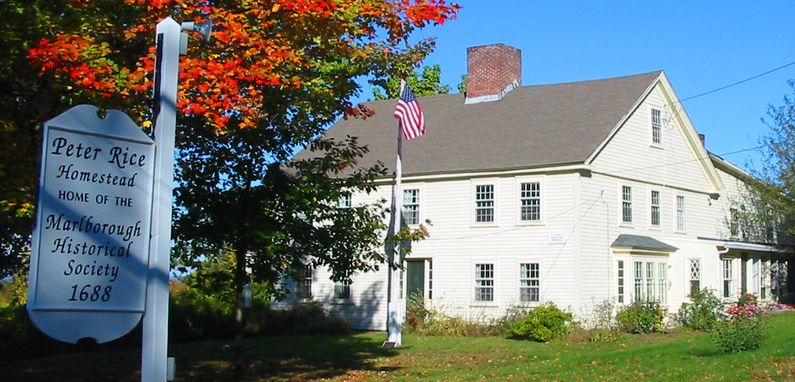
Capt. Peter Rice House
Monument and historic site · National Register of Historic Places · 1.4 mi
Building in Massachusetts, United States

Colonel Adelbert Mossman House
Monument and historic site · National Register of Historic Places · 2.9 mi
Historic house in Massachusetts, United States
Goodale Homestead
Monument and historic site · National Register of Historic Places · 3.0 mi
Building in Massachusetts, United States
Hapgood House
Monument and historic site · National Register of Historic Places · 5.3 mi
Building in Massachusetts, United States
J.D.C. Bradley House
Monument and historic site · National Register of Historic Places · 2.3 mi
Historic house in Massachusetts, United States


John Cotting House
Monument and historic site · National Register of Historic Places
Building in Massachusetts, United States
Maplewood Cemetery
Monument and historic site · National Register of Historic Places · 1.0 mi
Cemetery in Marlborough, Massachusetts
Marlborough Center Historic District
Monument and historic site · National Register of Historic Places
Historic district in Massachusetts, United States
Pan Historic District
Monument and historic site · National Register of Historic Places · 5.7 mi
Historic district in Massachusetts, United States
28 more on the map.
Parks, trails and playgrounds107



Beals Preserve
Hiking and trails · 3.2 mi
The Elaine and Philip Beals Preserve is a 58.5 acre parcel of open space gifted to the Southborough Open Land Foundation by Elaine and...
sunrise-sunset



95 more on the map.
Restaurants and cafes103

Atlantic Poké
Restaurant · Seafood · 2.4 mi
Atlantic Poké is a food concept serving all the great flavors you have grown to love from eating sushi and other exotic foods, in our...
237 Boston Post Rd W, Marlborough
Mo-Fr 11:00-19:30, Sa-Su 11:30-19:30
Evviva Trattoria
Restaurant · Italian, Regional · 2.3 mi
Family-friendly restaurant offering Italian appetizers, entrees & pizza in a festive atmosphere.
142 Apex Drive
Mo-We,Su 11:30-20:30; Th-Sa 11:30-21:30

Aero Coffee Roasters
Cafe · Coffee Shop, Sandwich, Dessert, Pastries · 3.9 mi
318 Main Street, Northborough
Mo-Fr 06:30-16:00, Sa-Su 07:00-15:00

Ben & Jerry's
Ice cream · Ice Cream · 2.3 mi
187 Boston Post Road West, Marlborough
Mo-Th,Su 12:00-21:00; Fr-Sa 12:00-23:00
Bolton Street Tavern
Restaurant · Pub · 1.2 mi
587 Bolton Street, Marlborough
Mo-We 11:00-24:00; Th 11:00-01:00; Fr-Sa 11:00-02:00; Su 10:00-24:00

LongHorn Steakhouse
Restaurant · Steak House · 2.2 mi
191 Boston Post Road West
Mo-Th,Su 11:00-22:00; Fr-Sa 11:00-23:00
Ninety Nine Restaurant & Pub
Diner · American · 1.9 mi
32 Boston Post Road West
Mo-We 11:00-21:30; Th-Sa 11:00-22:30; Su 11:00-21:00
Welly's Family Restaurant
Diner · American
153 Main Street, Marlborough
Mo-We 11:00-21:30; Th 11:00-22:00; Fr-Sa 11:00-22:30; Su 11:00-21:00
Wild Hare Café, Restaurant & Brewery
Cafe · Coffee Shop, Bakery, Breakfast, Lunch, Sandwich, Salad, Pastry · 2.8 mi
43 Broad Street, Hudson
Tu-Su 07:00-15:00
91 more on the map.
History
In 1656, several families from Sudbury, Massachusetts, led by Edmund Rice, John Howe, John Ruddock, and John Bent, petitioned the Massachusetts General Court to create a new town. The proposed town would be located southwest of Sudbury at the intersection of two trails used by local Native American tribes, known as the Nashua Trail and Connecticut path. Its name would be Marlborough, after the market town in Wiltshire, England of the same name.
The land belonged to a tribe of Pennacook Native Americans whose population had been decimated by the introduction of European diseases a few decades prior. In 1656, only 50 or so Pennacooks remained in the area. The Pennacook people spoke an Algonquian language; this was among the reasons that Howe, a fur trader who spoke Algonquian, became the first settler to move to the area. The Pennacook, knowing their reduced numbers left them vulnerable to attacks from other Native groups, initially welcomed the settlers in exchange for their assistance protecting the tribe.
From the History section of Marlborough, Massachusetts on Wikipedia, under CC BY-SA 4.0.
Where to stay12
Embassy Suites by Hilton Boston Marlborough
Motel and hotel · 2.1 mi
123 Boston Post Road West, Marlborough
Homewood Suites by Hilton Boston Marlborough;Homewood Suites
Motel and hotel · 4.0 mi
60 River Road West
Best Western Royal Plaza Hotel & Trade Center
Motel and hotel · 2.3 mi
181 Boston Post Road West, Marlborough
Extended Stay America
Motel and hotel · 1.9 mi
19 Northboro Road East, marlborough
Churches and places of worship31
First Baptist Church of Northborough
Church · National Register of Historic Places · 5.1 mi
Shopping27
Gas and EV charging15
Schools, colleges and libraries66
Healthcare8
Zenith Primary & Urgent Care
Clinic and pharmacy · 2.4 mi
757 Boston Post Road East, Marlborough
Map of Marlborough
250 places. The map loads OpenStreetMap tiles when you open it.
Climate by month
Monthly table
| Month | High | Low | Rain |
|---|---|---|---|
| Jan | 37°F | 15°F | 3.6 in |
| Feb | 41°F | 16°F | 3.3 in |
| Mar | 48°F | 24°F | 4.6 in |
| Apr | 62°F | 34°F | 4.4 in |
| May | 73°F | 45°F | 3.7 in |
| Jun | 81°F | 55°F | 4.2 in |
| Jul | 87°F | 60°F | 4.0 in |
| Aug | 85°F | 58°F | 4.4 in |
| Sep | 78°F | 49°F | 3.9 in |
| Oct | 66°F | 38°F | 5.1 in |
| Nov | 54°F | 29°F | 3.8 in |
| Dec | 43°F | 21°F | 4.8 in |
U.S. Climate Normals 1991-2020 for Maynard 2 (8 mi away), NOAA NCEI.
People and cost of living
American Community Survey 5-year estimates, 2020-2024, U.S. Census Bureau. Estimates have margins of error, larger for small towns.
Disaster history
Middlesex County has had 26 federal disaster declarations since 2000, most often for severe storms.
- 2023-09-15: Hurricane Lee (Hurricane)
- 2020-03-27: Covid-19 Pandemic (Biological)
- 2020-03-13: Covid-19 (Biological)
- 2018-07-19: Severe Winter Storm And Snowstorm (Snowstorm)
- 2015-04-13: Severe Winter Storm, Snowstorm, And Flooding (Severe Storm)
- 2013-04-19: Severe Winter Storm, Snowstorm, And Flooding (Severe Storm)
OpenFEMA disaster declarations summaries.
Getting there and nearby towns
Minute Man Airfield (MMN) is the nearest airport with scheduled flights listed in OpenStreetMap, 8 miles away.
- Hudson 3 mi north, about 5 min by car
- Framingham 6 mi southeast, about 10 min by car
- Worcester 14 mi west, about 23 min by car
- Leominster 16 mi northwest, about 26 min by car
- Lexington 17 mi east, about 28 min by car
- Belmont 19 mi east, about 30 min by car
- Franklin Town 20 mi south, about 32 min by car
- Arlington 20 mi east, about 32 min by car
- Dedham 20 mi east, about 32 min by car
- Brookline 21 mi east, about 33 min by car
Drive times are estimates from straight-line distance, not routes.
Local news
Headlines from INDB, the NEMICO news database.
Reviews, tips and questions
Loading what members have shared...
Sources and licences
- NCES EDGE (Public domain): public schools
- NOAA NCEI U.S. Climate Normals 1991-2020 (Public domain): climate by month
- OpenFEMA (Public domain): disaster declarations
- OpenStreetMap contributors (ODbL 1.0): places, airports, map data
- U.S. Census Bureau (Public domain): population, income, housing, education, commute
- Wikidata (CC0 1.0): elevation, founding date, time zone, website, landmarks and historic places
- Wikimedia Commons (see each image): photos
- Wikipedia (CC BY-SA 4.0): overview and history text
Photo credits
- Bethel Presbyterian Church and Soldiers Monument - Marlborough, MA - DSC04422, Daderot, CC0
- Main Street, Marlborough, with station and streetcar - postcard, Unknown author Unknown author, Public domain
- Headstone in Spring Hill Cemetery (1675) in Marlborough, Massachusetts (7233524420), Lee Wright from Marlborough, Massachusetts, US, CC BY-SA 2.0
- Headstone in Spring Hill Cemetery (1675) in Marlborough, Massachusetts (7233577504), Lee Wright from Marlborough, Massachusetts, US, CC BY-SA 2.0
- The copper plate atop the broken grave marker of William Brinsmead (1660 - 1701), first pastor of Marlborough (7233540724), Lee Wright from Marlborough, Massachusetts, US, CC BY-SA 2.0
- Headstones in Spring Hill Cemetery (1675) in Marlborough, Massachusetts (7233607948), Lee Wright from Marlborough, Massachusetts, US, CC BY-SA 2.0
- Headstones in Spring Hill Cemetery (1675) in Marlborough, Massachusetts (7233584888), Lee Wright from Marlborough, Massachusetts, US, CC BY-SA 2.0
- Headstones in Spring Hill Cemetery (1675) in Marlborough, Massachusetts (7233573920), Lee Wright from Marlborough, Massachusetts, US, CC BY-SA 2.0
- Headstones in Spring Hill Cemetery (1675) in Marlborough, Massachusetts (7233601362), Lee Wright from Marlborough, Massachusetts, US, CC BY-SA 2.0
- Marker in Spring Hill Cemetery in Marlborough, Massachusetts (7233629528), Lee Wright from Marlborough, Massachusetts, US, CC BY-SA 2.0
- Headstone in Spring Hill Cemetery (1675) in Marlborough, Massachusetts (7233638744), Lee Wright from Marlborough, Massachusetts, US, CC BY-SA 2.0
- Headstone in Spring Hill Cemetery (1675) in Marlborough, Massachusetts (7233575718), Lee Wright from Marlborough, Massachusetts, US, CC BY-SA 2.0
- Headstones in Spring Hill Cemetery (1675) in Marlborough, Massachusetts (7233553362), Lee Wright from Marlborough, Massachusetts, US, CC BY-SA 2.0
- Tombs in Spring Hill Cemetery in Marlborough, Massachusetts (7233508238), Lee Wright from Marlborough, Massachusetts, US, CC BY-SA 2.0
- Headstone in Spring Hill Cemetery (1675) in Marlborough, Massachusetts (7233650242), Lee Wright from Marlborough, Massachusetts, US, CC BY-SA 2.0
- Headstone in Spring Hill Cemetery (1675) in Marlborough, Massachusetts (7233569944), Lee Wright from Marlborough, Massachusetts, US, CC BY-SA 2.0
- Headstones in Spring Hill Cemetery (1675) in Marlborough, Massachusetts (7233519552), Lee Wright from Marlborough, Massachusetts, US, CC BY-SA 2.0
- Headstone in Spring Hill Cemetery (1675) in Marlborough, Massachusetts (7233531938), Lee Wright from Marlborough, Massachusetts, US, CC BY-SA 2.0
- Headstone in Spring Hill Cemetery (1675) in Marlborough, Massachusetts (7233579272), Lee Wright from Marlborough, Massachusetts, US, CC BY-SA 2.0
- Headstones in Spring Hill Cemetery (1675) in Marlborough, Massachusetts (7233586916), Lee Wright from Marlborough, Massachusetts, US, CC BY-SA 2.0
- The broken grave marker of William Brinsmead (1660 - 1701), first pastor of Marlborough (7233543442), Lee Wright from Marlborough, Massachusetts, US, CC BY-SA 2.0
- Headstone in Spring Hill Cemetery (1675) in Marlborough, Massachusetts (7233526886), Lee Wright from Marlborough, Massachusetts, US, CC BY-SA 2.0
- Headstones in Spring Hill Cemetery (1675) in Marlborough, Massachusetts (7233589008), Lee Wright from Marlborough, Massachusetts, US, CC BY-SA 2.0
- The broken grave marker of William Brinsmead (1660 - 1701), first pastor of Marlborough (7233539414), Lee Wright from Marlborough, Massachusetts, US, CC BY-SA 2.0
- Headstones in Spring Hill Cemetery (1675) in Marlborough, Massachusetts (7233594704), Lee Wright from Marlborough, Massachusetts, US, CC BY-SA 2.0
- Headstone in Spring Hill Cemetery (1675) in Marlborough, Massachusetts (7233644750), Lee Wright from Marlborough, Massachusetts, US, CC BY-SA 2.0
- Headstone in Spring Hill Cemetery (1675) in Marlborough, Massachusetts (7233666600), Lee Wright from Marlborough, Massachusetts, US, CC BY-SA 2.0
- Headstones in Spring Hill Cemetery (1675) in Marlborough, Massachusetts (7233590432), Lee Wright from Marlborough, Massachusetts, US, CC BY-SA 2.0
- Headstones in Spring Hill Cemetery (1675) in Marlborough, Massachusetts (7233617436), Lee Wright from Marlborough, Massachusetts, US, CC BY-SA 2.0
- Tombs in Spring Hill Cemetery in Marlborough, Massachusetts (7233497984), Lee Wright from Marlborough, Massachusetts, US, CC BY-SA 2.0
- Headstones in Spring Hill Cemetery (1675) in Marlborough, Massachusetts (7233606118), Lee Wright from Marlborough, Massachusetts, US, CC BY-SA 2.0
- Headstone in Spring Hill Cemetery (1675) in Marlborough, Massachusetts (7233551104), Lee Wright from Marlborough, Massachusetts, US, CC BY-SA 2.0
- Headstones in Spring Hill Cemetery (1675) in Marlborough, Massachusetts (7233634984), Lee Wright from Marlborough, Massachusetts, US, CC BY-SA 2.0
- Headstone in Spring Hill Cemetery (1675) in Marlborough, Massachusetts (7233609760), Lee Wright from Marlborough, Massachusetts, US, CC BY-SA 2.0
- Headstone in Spring Hill Cemetery (1675) in Marlborough, Massachusetts (7233557058), Lee Wright from Marlborough, Massachusetts, US, CC BY-SA 2.0
- Headstones and markers in Spring Hill Cemetery (1675) in Marlborough, Massachusetts (7233546098), Lee Wright from Marlborough, Massachusetts, US, CC BY-SA 2.0
- John Cotting House, Tim Pierce, CC BY-SA 3.0
- MarlboroughMA WeeksCemetery, User:Magicpiano, CC BY-SA 4.0
- Capt Peter Rice House, Lee Wright / Marlborough Historical Society (www.HistoricMarlborough.org), CC BY 4.0
- Colonel Adelbert Mossman House, Tim Pierce, CC BY-SA 3.0


Page built October 30, 2026. Spotted a mistake? Tell us or suggest a place.