



Colonial Beach, Virginia
Colonial Beach is a town of 3,966 people in Westmoreland County, Virginia, founded in 1892.
Why visit Colonial Beach
Townapedia lists 2 museums and landmarks, 2 parks and trails and 10 places to eat in and around town.
Highlights include Bell House, James Monroe Family Home Site and Bayside Marina.
July is the warmest month, with average highs of 87°F; January lows average 26°F.
Weather in Colonial Beach
Forecast from the National Weather Service. Full forecast
About Colonial Beach
Colonial Beach, Virginia (CBVA) is a river and beach town located in the northwestern part of Westmoreland County on Virginia's Northern Neck peninsula. It is bounded by the Potomac River, Monroe Bay and Monroe Creek. It is located 65 mi (105 km) from Washington, D.C.; 70 mi (110 km) from the state capital of Richmond; and 35 nautical miles from the Chesapeake Bay.
From the Wikipedia article Colonial Beach, Virginia (this version), under CC BY-SA 4.0.
Museums and landmarks2


Bell House
Monument and historic site · National Register of Historic Places · 2.4 mi
Summer home of Alexander Graham Bell in Colonial Beach, Virginia, United States
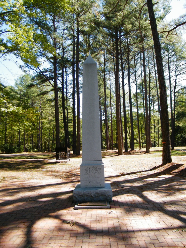
James Monroe Family Home Site
Monument and historic site · National Register of Historic Places · 1.3 mi
Archaeological site in Virginia, United States
Parks, trails and playgrounds2


Restaurants and cafes10

El Toro Authentic
Restaurant · Mexican · 1.0 mi
700 McKinney Boulevard, Colonial Beach
Su-Th 11:00-21:00; Fr-Sa 11:00-22:00

Fire Escape American Grille
Diner · American · 1.1 mi
1010 McKinney Boulevard, Colonial Beach
Tu-Th 17:00-20:00; Fr 17:00-21:00; Sa 16:00-21:00; Su 10:00-14:00
Lenny's Restaurant
Diner · American · 1.6 mi
301 Colonial Avenue, Colonial Beach
Mo-Su 06:00-15:00
Tops China
Restaurant · Chinese · 1.1 mi
7000 McKinney Boulevard, Colonial Beach
Tu-Th 11:30-21:00; Fr-Sa 11:30-21:30; Su 12:00-21:00


Domino's
Fast food · Pizza · 1.1 mi
700 McKinney Boulevard, Colonial Beach
Su-Th 10:30-23:00; Fr-Sa 10:30-00:00
Churches and places of worship3

History
Judging by excavations done on oyster pits, it would seem that Native Americans have inhabited the area of modern-day Colonial Beach since at least the Early Woodland Period (500 B.C.- A.D. 900).
The town area now known as ‘The Point’ was originally patented by John Lancelott and S. Lancelott [Odyer and Sturman Escheat] on October 29, 1651.
Colonial Beach emerged as a bathing and fishing resort in the late 19th century known as the "Playground on the Potomac." Prior to automobile travel, most visitors arrived by boat from Washington, D.C.
The town was incorporated on February 25, 1892, and there was extensive construction of houses, summer cottages, and hotels. Arguably the most famous of these structures is the Bell House, built for Alexander Graham Bell as a summer home, which still stands today on Irving Avenue.
The area was at the center of the Potomac River Oyster Wars between Virginia watermen and the Maryland State Oyster Police that lasted from the late 19th century to the 1960s.
From the History section of Colonial Beach, Virginia on Wikipedia, under CC BY-SA 4.0.
Shopping1
Gas and EV charging2
Schools, colleges and libraries5
Washington District Elementary
School · 5.5 mi
454 Oak Grove Road, Colonial Beach
Healthcare2
East Coast Physicians, P.C.
Clinic and pharmacy · 1.3 mi
525 Euclid Avenue, Colonial Beach
Map of Colonial Beach
27 places. The map loads OpenStreetMap tiles when you open it.
Climate by month
Monthly table
| Month | High | Low | Rain | Snow |
|---|---|---|---|---|
| Jan | 45°F | 26°F | 3.3 in | 3.6 in |
| Feb | 48°F | 28°F | 2.9 in | 5.0 in |
| Mar | 57°F | 35°F | 3.9 in | 0.9 in |
| Apr | 68°F | 44°F | 3.5 in | 0.1 in |
| May | 75°F | 54°F | 4.1 in | 0.0 in |
| Jun | 83°F | 62°F | 4.0 in | 0.0 in |
| Jul | 87°F | 67°F | 4.0 in | 0.0 in |
| Aug | 86°F | 65°F | 3.5 in | 0.0 in |
| Sep | 79°F | 58°F | 4.7 in | 0.0 in |
| Oct | 69°F | 47°F | 4.0 in | 0.0 in |
| Nov | 58°F | 37°F | 3.3 in | 0.1 in |
| Dec | 49°F | 30°F | 3.6 in | 1.8 in |
U.S. Climate Normals 1991-2020 for Corbin (21 mi away), NOAA NCEI.
People and cost of living
American Community Survey 5-year estimates, 2020-2024, U.S. Census Bureau. Estimates have margins of error, larger for small towns.
Disaster history
Westmoreland County has had 15 federal disaster declarations since 2000, most often for hurricanes.
- 2026-01-23: Severe Winter Storm (Winter Storm)
- 2022-03-11: Severe Winter Storm And Snowstorm (Severe Storm)
- 2020-04-02: Covid-19 Pandemic (Biological)
- 2020-03-13: Covid-19 (Biological)
- 2018-12-18: Tropical Storm Michael (Hurricane)
- 2018-09-11: Hurricane Florence (Hurricane)
OpenFEMA disaster declarations summaries.
Getting there and nearby towns
Naval Support Facility Dahlgren (DGN) is the nearest airport with scheduled flights listed in OpenStreetMap, 6 miles away.
- Mechanicsville 18 mi northeast, about 29 min by car
- Charlotte Hall 18 mi northeast, about 30 min by car
- Leonardtown 19 mi east, about 31 min by car
- La Plata 20 mi north, about 31 min by car
- Golden Beach 22 mi northeast, about 36 min by car
- Bensville 24 mi north, about 39 min by car
- Bryans Road 24 mi north, about 39 min by car
- Wildewood 24 mi east, about 39 min by car
- Waldorf 25 mi north, about 40 min by car
- Cherry Hill 26 mi northwest, about 43 min by car
Drive times are estimates from straight-line distance, not routes.
Local news
Headlines from INDB, the NEMICO news database.
Reviews, tips and questions
Loading what members have shared...
Sources and licences
- NCES EDGE (Public domain): public schools
- NOAA NCEI U.S. Climate Normals 1991-2020 (Public domain): climate by month
- OpenFEMA (Public domain): disaster declarations
- OpenStreetMap contributors (ODbL 1.0): places, airports, map data
- U.S. Census Bureau (Public domain): population, income, housing, education, commute
- Wikidata (CC0 1.0): elevation, founding date, time zone, website, landmarks and historic places
- Wikimedia Commons (see each image): photos
- Wikipedia (CC BY-SA 4.0): overview and history text
Photo credits
- Pier at Colonial Beach, Ser Amantio di Nicolao at English Wikipedia, CC BY-SA 3.0
- 2017-07-05 07 14 32 View east along Virginia State Route 205 (McKinney Boulevard) at Virginia State Route 205Y (Colonial Avenue) in Colonial Beach, Westmoreland County, Virginia, Famartin, CC BY-SA 4.0
- Hunan Diner in Colonial Beach, front, Nyttend, Public domain
- Hunan Diner in Colonial Beach, slight angle, Nyttend, Public domain
- James Monroe Family Home Site - Stierch, Sarah Stierch, CC BY 4.0
- Alexander Graham Bell's Summer Home in Colonial Beach, Virginia, Suzyramble, CC BY-SA 3.0
- VA State Routes 205 and 205Y, AjaxSmack, CC BY-SA 3.0
- Birthplace of Monroe historical marker, Nyttend, Public domain


Page built October 30, 2026. Spotted a mistake? Tell us or suggest a place.