


Compton, California
Compton is a city of 92,698 people in Los Angeles County, California.
Why visit Compton
Townapedia lists 8 museums and landmarks, 50 parks and trails, 129 places to eat, 7 places to stay and 2 attractions in and around town.
Highlights include Piedmont University, Dominguez Rancho Adobe, Los Cerritos Ranch House and Mona Park.
August is the warmest month, with average highs of 79°F; December lows average 49°F.
Weather in Compton
Forecast from the National Weather Service. Full forecast
About Compton
Compton is a city located in the Gateway Cities region of southern Los Angeles County, California, United States, situated south of downtown Los Angeles. Compton is one of the oldest cities in the county, and in May 1888, was the eighth city in Los Angeles County to incorporate. In the 2020 census, the city had a population of 95,740.
From the Wikipedia article Compton, California (this version), under CC BY-SA 4.0.
Things to do2

Piedmont University
School · 4.7 mi
Christian university in Los Angeles, California, U.S

Museums and landmarks8

Dominguez Rancho Adobe
Monument and historic site · National Register of Historic Places · 2.0 mi
Building in California, United States
Los Cerritos Ranch House
Monument and historic site · National Register of Historic Places · 4.4 mi
Historic house in California, United States
Lynwood Pacific Electric Railway Depot
Monument and historic site · National Register of Historic Places · 2.4 mi
Railway station of the Pacific Electric Railway, located in Lynwood, California
Watts Station
Monument and historic site · National Register of Historic Places · 3.5 mi
Railway station in Los Angeles, the United States of America
Watts Towers
Monument and historic site · National Register of Historic Places · 3.2 mi
Towers in Los Angeles
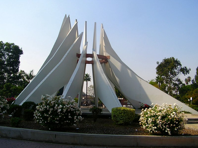
Martin Luther King, Jr. Memorial
Monument and historic site
Sculpture in Compton, California, USA

Parks, trails and playgrounds50


38 more on the map.
Restaurants and cafes129


Pizza Hut
Restaurant · Pizza · 2.4 mi
11710 Wilmington Avenue, Los Angeles
Mo-Th,Su 10:00-23:00; Fr-Sa 10:00-24:00


Alma's Cookies & Company Restaurant
Restaurant
Soul Food Restaurant in Compton
312 West Compton Boulevard
BALAM Mexican Kitchen
Restaurant · Mexican · 2.2 mi
11700 Long Beach Boulevard, Lynwood
Tu-Fr 10:00-20:00; Sa 08:00-20:00; Su 08:00-18:00
El Cielo Comida Latina
Restaurant · 1.3 mi
Latino food
2020 Santa Fe Avenue
Mo-Su 08:00-20:00
Jay Bee's Memphis Style Bar-B-Q
Restaurant · Barbecue · 2.2 mi
15911 South Avalon Boulevard, Gardena
Mo 11:00-19:00; Tu-Sa 11:00-22:00; Su off
M&M Sould Food
Restaurant · Soul Food · 2.9 mi
335 East Albertoni Street, Carson
Mo-Su 08:00-20:00
117 more on the map.
History
The Spanish Empire had expanded into this area when the Viceroy of New Spain commissioned Juan Rodríguez Cabrillo to explore the Pacific Ocean in 1542–1543. In 1767, the area became part of the Province of the Californias (Spanish: Provincia de las Californias), and the area was explored by the Portolá expedition in 1769–1770. In 1784, the Spanish Crown deeded Rancho San Pedro, a tract of over 75,000 acres (300 km2), to soldier Juan José Domínguez.
Domínguez's descendants partitioned the land amongst family members, sold parcels to newly arriving settlers, and relinquished some when validating their legal claim with the Mexican government at 48,000 acres (190 km2) in 1828, and with the United States government through a patent validating 43,119 acres (174.50 km2) in 1858. The Domínguez family name is still applied throughout the area, including the Dominguez Rancho Adobe historical landmark, in the unincorporated community of Rancho Dominguez, located between the cities of Compton, Long Beach and Carson. The tree that marked the original northern boundary of the rancho still stands at the corner of Poppy and Short streets.
From the History section of Compton, California on Wikipedia, under CC BY-SA 4.0.
Where to stay7
Churches and places of worship139
First Samoan Full Gospel Outreach
Church · United Church Of Christ · 1.4 mi
300 North Central Avenue, Compton
St. Albert the Great Church
Church · Roman Catholic · 2.0 mi
804 East Compton Boulevard, Rancho Dominguez
Church of the Redeemer
Church · Presbyterian · 2.0 mi
900 East Rosecrans Avenue, Los Angeles
Holy Chapel Missionary Baptist Church
Church · Baptist · 1.8 mi
1016 East Rosecrans Avenue, Compton
Shopping20
Gas and EV charging25
Schools, colleges and libraries123
St. Albert the Great Elementary School
School · Roman Catholic · 1.9 mi
804 East Compton Boulevard, Rancho Dominguez
Healthcare11
Martin Luther King, Jr. Center for Public Health
Clinic and pharmacy · 2.2 mi
11833 South Wilmington Avenue, Los Angeles
Map of Compton
250 places. The map loads OpenStreetMap tiles when you open it.
Climate by month
Monthly table
| Month | High | Low | Rain |
|---|---|---|---|
| Jan | 67°F | 49°F | 2.7 in |
| Feb | 67°F | 51°F | 3.0 in |
| Mar | 68°F | 53°F | 1.7 in |
| Apr | 70°F | 55°F | 0.6 in |
| May | 71°F | 58°F | 0.3 in |
| Jun | 73°F | 62°F | 0.0 in |
| Jul | 77°F | 65°F | 0.0 in |
| Aug | 79°F | 65°F | 0.0 in |
| Sep | 78°F | 64°F | 0.2 in |
| Oct | 76°F | 60°F | 0.5 in |
| Nov | 72°F | 54°F | 0.7 in |
| Dec | 66°F | 49°F | 2.2 in |
U.S. Climate Normals 1991-2020 for Hawthorne Muni Ap (6 mi away), NOAA NCEI.
People and cost of living
American Community Survey 5-year estimates, 2020-2024, U.S. Census Bureau. Estimates have margins of error, larger for small towns.
Disaster history
Los Angeles County has had 67 federal disaster declarations since 2000, most often for fires.
- 2025-08-08: Canyon Fire (Fire)
- 2025-01-08: Wildfires And Straight-Line Winds (Fire)
- 2025-01-08: Eaton Fire (Fire)
- 2025-01-08: Hurst Fire (Fire)
- 2025-01-07: Palisades Fire (Fire)
- 2024-12-10: Franklin Fire (Fire)
OpenFEMA disaster declarations summaries.
Getting there and nearby towns
Compton / Woodley Airport (CPM) is the nearest airport with scheduled flights listed in OpenStreetMap, 1 miles away.
- East Rancho Dominguez 2 mi east, about 3 min by car
- Willowbrook 2 mi north, about 3 min by car
- West Rancho Dominguez 2 mi west, about 4 min by car
- Lynwood 3 mi northeast, about 4 min by car
- Paramount 4 mi east, about 6 min by car
- Carson 4 mi south, about 6 min by car
- South Gate 4 mi northeast, about 6 min by car
- Gardena 5 mi west, about 7 min by car
- Florence-Graham 5 mi north, about 8 min by car
- Westmont 5 mi northwest, about 9 min by car
Drive times are estimates from straight-line distance, not routes.
Local news
Headlines from INDB, the NEMICO news database.
Reviews, tips and questions
Loading what members have shared...
Sources and licences
- NCES EDGE (Public domain): public schools
- NOAA NCEI U.S. Climate Normals 1991-2020 (Public domain): climate by month
- OpenFEMA (Public domain): disaster declarations
- OpenStreetMap contributors (ODbL 1.0): places, airports, map data
- U.S. Census Bureau (Public domain): population, income, housing, education, commute
- Wikidata (CC0 1.0): elevation, founding date, time zone, website, landmarks and historic places
- Wikimedia Commons (see each image): photos
- Wikipedia (CC BY-SA 4.0): overview and history text
Photo credits
- Compton martin luther king monument, Epolk at English Wikipedia, CC BY 3.0
- Heritage House (Compton, California), LittleT889, CC BY-SA 4.0
- Compton Superior Court, Jengod, CC BY-SA 4.0
- Compton post office 90223 in 2024 February 04, Jengod, CC BY-SA 4.0
- Compton post office 90223 in 2024 February 01, Jengod, CC BY-SA 4.0
- Compton post office 90223 in 2024 February 03, Jengod, CC BY-SA 4.0
- Compton post office 90223 in 2024 February 08, Jengod, CC BY-SA 4.0
- Compton post office 90223 in 2024 February 06, Jengod, CC BY-SA 4.0
- Compton post office 90223 in 2024 February 07, Jengod, CC BY-SA 4.0
- Compton post office 90223 in 2024 February 02, Jengod, CC BY-SA 4.0
- Compton post office 90223 in 2024 February 05, Jengod, CC BY-SA 4.0
- Franklin D. Roosevelt Middle School (Compton, California) 01, Jengod, CC BY-SA 4.0
- Franklin D. Roosevelt Middle School (Compton, California) 02, Jengod, CC BY-SA 4.0
- Compton Unified School District school bus 2024, Jengod, CC BY-SA 4.0
- Gardena Freeway (S.R. 91), Compton, California (6026570475), Ken Lund from Reno, Nevada, USA, CC BY-SA 2.0
- Entering compton, donielle from los angeles, usa, CC BY-SA 2.0
- Colin P. Kelly Elementary School (Compton, California), Jengod, CC BY-SA 4.0
- Dale's Donuts 15904 S. Atlantic Ave Compton CA 03, Jengod, CC BY-SA 4.0
- Dale's Donuts 15904 S. Atlantic Ave Compton CA 02, Jengod, CC BY-SA 4.0
- Dale's Donuts 15904 S. Atlantic Ave Compton CA 01, Jengod, CC BY-SA 4.0
- North American T-28A rain maker (5191517744), Bill Larkins, CC BY-SA 2.0
- Early California by James Redmond - panel over postmaster's office door, Jengod, CC BY-SA 4.0
- Alameda corridor trench, Thomas Brightbill, CC BY 2.0
- 19951007 09 RTD Blue Line (5378831619), David Wilson from Oak Park, Illinois, USA, CC BY 2.0
- The People's Garden (20221021-FPAC-LSC-0007), USDAgov, Public domain
- The People's Garden (20221021-FPAC-LSC-0004), USDAgov, Public domain
- The People's Garden (20221021-FPAC-LSC-0006), USDAgov, Public domain
- The People's Garden (20221021-FPAC-LSC-0002), USDAgov, Public domain
- Minutes To RTE 605 on 91 East, Sdogg7159, CC BY-SA 4.0
- Jacoby & Meyers Injury Lawyer Blayne Response Billboard Ad, Sdogg7159, CC0
- ISS060-E-78523 - View of Earth, Earth Science and Remote Sensing Unit, NASA Johnson Space Center, Public domain
- ISS027-E-28808 - View of California, Earth Science and Remote Sensing Unit , Lyndon B. Johnson Space Center, Public domain
- ISS061-E-28693 - View of Earth, Earth Science and Remote Sensing Unit, NASA Johnson Space Center, Public domain
- ISS065-E-350552 - View of Earth, Earth Science and Remote Sensing Unit , Lyndon B. Johnson Space Center, Public domain
- Exit 11 Long Beach Blvd, Sdogg7159, CC BY-SA 4.0
- Amazon Prime trailer, Eric Polk, CC BY-SA 4.0
- Atlantic Ave USE 710 NORTH, Sdogg7159, CC BY-SA 4.0


Page built October 30, 2026. Spotted a mistake? Tell us or suggest a place.