


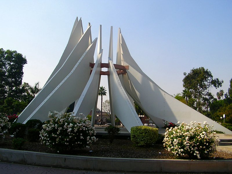

West Rancho Dominguez, California
West Rancho Dominguez is a community of 23,300 people in Los Angeles County, California.
Why visit West Rancho Dominguez
Townapedia lists 7 museums and landmarks, 16 parks and trails, 51 places to eat, 4 places to stay and 2 attractions in and around town.
Highlights include California State University, Dominguez Hills, Piedmont University, Dominguez Rancho Adobe and Lynwood Pacific Electric Railway Depot.
August is the warmest month, with average highs of 79°F; December lows average 49°F.
Weather in West Rancho Dominguez
Forecast from the National Weather Service. Full forecast
About West Rancho Dominguez
West Rancho Dominguez, () formerly known as West Compton and also known as East Gardena, is an unincorporated census-designated place (CDP) located in southern Los Angeles County, California. Per the 2020 census, the population was 24,347. The community lies to the west (but is not a part) of the city of Compton. The ZIP Codes encompassing the CDP area are 90220 & 90248.
From the Wikipedia article West Rancho Dominguez, California (this version), under CC BY-SA 4.0.
Things to do2

California State University, Dominguez Hills
School · 2.8 mi
University

Piedmont University
School · 2.6 mi
Christian university in Los Angeles, California, U.S
Museums and landmarks7

Dominguez Rancho Adobe
Monument and historic site · National Register of Historic Places · 3.9 mi
Building in California, United States
Lynwood Pacific Electric Railway Depot
Monument and historic site · National Register of Historic Places · 3.7 mi
Railway station of the Pacific Electric Railway, located in Lynwood, California


Watts Station
Monument and historic site · National Register of Historic Places · 3.0 mi
Railway station in Los Angeles, the United States of America
Watts Towers
Monument and historic site · National Register of Historic Places · 2.8 mi
Towers in Los Angeles
Martin Luther King, Jr. Memorial
Monument and historic site · 2.5 mi
Sculpture in Compton, California, USA


Parks, trails and playgrounds16

4 more on the map.
Restaurants and cafes51


El Nuevo San Miguel
Restaurant · Salvadoran, Mexican · 1.8 mi
1314 Rosecrans Avenue, Gardena
Mo-Su 08:00-20:30

Jay Bee's Memphis Style Bar-B-Q
Restaurant · Barbecue · 1.2 mi
15911 South Avalon Boulevard, Gardena
Mo 11:00-19:00; Tu-Sa 11:00-22:00; Su off



Avalon Donuts & Deli
Fast food · Donut · 1.1 mi
15801 South Avalon Boulevard, Gardena
Mo-Fr 03:30-17:00; Sa 03:30-14:00
39 more on the map.
Where to stay4
Churches and places of worship73
First Samoan Full Gospel Outreach
Church · United Church Of Christ · 1.0 mi
300 North Central Avenue, Compton
St. Albert the Great Church
Church · Roman Catholic · 0.7 mi
804 East Compton Boulevard, Rancho Dominguez
Church of the Redeemer
Church · Presbyterian · 0.5 mi
900 East Rosecrans Avenue, Los Angeles
Holy Chapel Missionary Baptist Church
Church · Baptist · 0.6 mi
1016 East Rosecrans Avenue, Compton
Shopping6
Gas and EV charging20
Schools, colleges and libraries79
St. Albert the Great Elementary School
School · Roman Catholic · 0.8 mi
804 East Compton Boulevard, Rancho Dominguez
St. Albert the Great Middle School
School · Roman Catholic · 0.7 mi
823 East Compton Boulevard, Rancho Dominguez
Alain Leroy Locke College Preparatory Academy
School · 2.1 mi
325 East 111Th St., Los Angeles
Alliance College-Ready Middle Academy 4
School · 3.0 mi
9719 South Main St., Los Angeles
Alliance Collins Family College-Ready High
School · 5.4 mi
2071 Saturn Ave., Huntington Park
Alliance Judy Ivie Burton Technology Academy High
School · 2.8 mi
10101 South Broadway, Los Angeles
Alliance Margaret M. Bloomfield Technology Academy High
School · 4.8 mi
7907 Santa Fe Ave., Huntington Park
Healthcare7
Map of West Rancho Dominguez
250 places. The map loads OpenStreetMap tiles when you open it.
Climate by month
Monthly table
| Month | High | Low | Rain |
|---|---|---|---|
| Jan | 67°F | 49°F | 2.7 in |
| Feb | 67°F | 51°F | 3.0 in |
| Mar | 68°F | 53°F | 1.7 in |
| Apr | 70°F | 55°F | 0.6 in |
| May | 71°F | 58°F | 0.3 in |
| Jun | 73°F | 62°F | 0.0 in |
| Jul | 77°F | 65°F | 0.0 in |
| Aug | 79°F | 65°F | 0.0 in |
| Sep | 78°F | 64°F | 0.2 in |
| Oct | 76°F | 60°F | 0.5 in |
| Nov | 72°F | 54°F | 0.7 in |
| Dec | 66°F | 49°F | 2.2 in |
U.S. Climate Normals 1991-2020 for Hawthorne Muni Ap (4 mi away), NOAA NCEI.
People and cost of living
American Community Survey 5-year estimates, 2020-2024, U.S. Census Bureau. Estimates have margins of error, larger for small towns.
Disaster history
Los Angeles County has had 67 federal disaster declarations since 2000, most often for fires.
- 2025-08-08: Canyon Fire (Fire)
- 2025-01-08: Wildfires And Straight-Line Winds (Fire)
- 2025-01-08: Eaton Fire (Fire)
- 2025-01-08: Hurst Fire (Fire)
- 2025-01-07: Palisades Fire (Fire)
- 2024-12-10: Franklin Fire (Fire)
OpenFEMA disaster declarations summaries.
Getting there and nearby towns
Compton / Woodley Airport (CPM) is the nearest airport with scheduled flights listed in OpenStreetMap, 2 miles away.
- Willowbrook 2 mi northeast, about 3 min by car
- Compton 2 mi east, about 4 min by car
- Gardena 2 mi west, about 4 min by car
- West Athens 2 mi northwest, about 4 min by car
- Westmont 3 mi northwest, about 5 min by car
- Lynwood 4 mi east, about 6 min by car
- Alondra Park 4 mi west, about 6 min by car
- East Rancho Dominguez 4 mi east, about 7 min by car
- Carson 5 mi south, about 7 min by car
- Hawthorne 5 mi west, about 8 min by car
Drive times are estimates from straight-line distance, not routes.
Local news
Headlines from INDB, the NEMICO news database.
Reviews, tips and questions
Loading what members have shared...
Sources and licences
- NCES EDGE (Public domain): public schools
- NOAA NCEI U.S. Climate Normals 1991-2020 (Public domain): climate by month
- OpenFEMA (Public domain): disaster declarations
- OpenStreetMap contributors (ODbL 1.0): places, airports, map data
- U.S. Census Bureau (Public domain): population, income, housing, education, commute
- Wikidata (CC0 1.0): elevation, founding date, time zone, website, landmarks and historic places
- Wikimedia Commons (see each image): photos
- Wikipedia (CC BY-SA 4.0): overview and history text
Photo credits
- Dominguez Rancho Adobe Museum, Vanesser III, CC BY-SA 2.0
- Highsmithwattstowers, Carol M. Highsmith, Public domain
- Lynwood Pacific Electric Railway Depot (Lynwood, CA), John F. Meyerpeter, HABS photographer, Public domain
- Watts Station, Los Angeles, Los Angeles, CC BY-SA 3.0
- Compton martin luther king monument, Epolk at English Wikipedia, CC BY 3.0
- New-sci-innov-bldg, Wiki-bulum, CC BY-SA 4.0
- BMW X6 sDrive40i (G06, 2021) (53488000190), Charles from Port Chester, New York, CC BY 2.0
- Entering Interstate 110, Harbor Gateway, Los Angeles, California (6027122768), Ken Lund from Reno, Nevada, USA, CC BY-SA 2.0
- Anser serrirostris 339618421, Adam Jackson, CC0
- BMW 3-Series Coupé (E92) 328i (2009) (53487730723), Charles from Port Chester, New York, CC BY 2.0
- The People's Garden (20221021-FPAC-LSC-0002), USDAgov, Public domain
- The People's Garden (20221021-FPAC-LSC-0004), USDAgov, Public domain
- The People's Garden (20221021-FPAC-LSC-0006), USDAgov, Public domain
- The People's Garden (20221021-FPAC-LSC-0007), USDAgov, Public domain
- Mercedes-Benz S-Klasse (W223) S 580 4MATIC (2024) (54206757976), Charles from Port Chester, New York, CC BY 2.0
- Porsche Cayenne GTS Coupé (2023) (54207010184), Charles from Port Chester, New York, CC BY 2.0
- Porsche 911 Carrera GTS (991, 2016) (54207008058), Charles from Port Chester, New York, CC BY 2.0
- Hyundai Kona N Line (2023) (54207070735), Charles from Port Chester, New York, CC BY 2.0
- Porsche Cayenne GTS Coupé (2023) (54207183090), Charles from Port Chester, New York, CC BY 2.0
- BMW X7 xDrive40i (G07, 2024) (54207028705), Charles from Port Chester, New York, CC BY 2.0
- Rosecrans Avenue, Gardena, California (6027121998), Ken Lund from Reno, Nevada, USA, CC BY-SA 2.0
- Volvo V60 T5 Cross Country (2020) (55260314350), Charles from Port Chester, New York, CC0
- Freeway 110 & 105 (8728394685), Prayitno / Thank you for (12 millions +) view from Los Angeles, USA, CC BY 2.0
- 105 ^ 110 Freeway Junction - panoramio, Steve D, CC BY-SA 3.0
- ISS066-E-51318 - View of Earth, Earth Science and Remote Sensing Unit , Lyndon B. Johnson Space Center, Public domain
- ISS027-E-31033 - View of California, Earth Science and Remote Sensing Unit , Lyndon B. Johnson Space Center, Public domain
- ISS061-E-28692 - View of Earth, Earth Science and Remote Sensing Unit, NASA Johnson Space Center, Public domain
- ISS040-E-91206 - View of California, Earth Science and Remote Sensing Unit , Lyndon B. Johnson Space Center, Public domain
- ISS066-E-46402 - View of Earth, Earth Science and Remote Sensing Unit , Lyndon B. Johnson Space Center, Public domain
- ISS066-E-50288 - View of Earth, Earth Science and Remote Sensing Unit , Lyndon B. Johnson Space Center, Public domain
- ISS066-E-46401 - View of Earth, Earth Science and Remote Sensing Unit , Lyndon B. Johnson Space Center, Public domain
- ISS053-E-219357 - View of Earth, Earth Science and Remote Sensing Unit , Lyndon B. Johnson Space Center, Public domain
- ISS053-E-422121 - View of Earth, Earth Science and Remote Sensing Unit , Lyndon B. Johnson Space Center, Public domain
- ISS066-E-50287 - View of Earth, Earth Science and Remote Sensing Unit , Lyndon B. Johnson Space Center, Public domain
- ISS065-E-84457 - View of Earth, Earth Science and Remote Sensing Unit , Lyndon B. Johnson Space Center, Public domain
- ISS053-E-422120 - View of Earth, Earth Science and Remote Sensing Unit , Lyndon B. Johnson Space Center, Public domain
- ISS066-E-51317 - View of Earth, Earth Science and Remote Sensing Unit , Lyndon B. Johnson Space Center, Public domain
- ISS053-E-219356 - View of Earth, Earth Science and Remote Sensing Unit , Lyndon B. Johnson Space Center, Public domain
- STS133-E-7970 - View of California, NASA, Public domain
- Rosecrans and Normandie Avenue, Gardena, California (6026567839), Ken Lund from Reno, Nevada, USA, CC BY-SA 2.0


Page built October 30, 2026. Spotted a mistake? Tell us or suggest a place.