


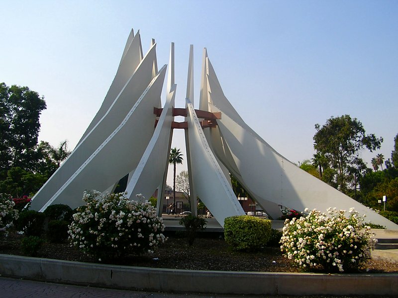
Willowbrook, California
Willowbrook is a community of 21,681 people in Los Angeles County, California.
Why visit Willowbrook
Townapedia lists 5 museums and landmarks, 27 parks and trails, 20 places to eat, 1 place to stay and 1 attraction in and around town.
Highlights include Piedmont University, Lynwood Pacific Electric Railway Depot, Watts Station and Mona Park.
August is the warmest month, with average highs of 79°F; December lows average 49°F.
Weather in Willowbrook
Forecast from the National Weather Service. Full forecast
About Willowbrook
Willowbrook, alternatively named Willow Brook, is an unincorporated community and census-designated place (CDP) in Los Angeles County, California, United States. The population was 24,295 at the 2020 census.
From the Wikipedia article Willowbrook, California (this version), under CC BY-SA 4.0.
Things to do1

Piedmont University
School · 3.3 mi
Christian university in Los Angeles, California, U.S
Museums and landmarks5
Lynwood Pacific Electric Railway Depot
Monument and historic site · National Register of Historic Places · 1.6 mi
Railway station of the Pacific Electric Railway, located in Lynwood, California


Watts Station
Monument and historic site · National Register of Historic Places · 1.6 mi
Railway station in Los Angeles, the United States of America
Watts Towers
Monument and historic site · National Register of Historic Places · 1.3 mi
Towers in Los Angeles
Martin Luther King, Jr. Memorial
Monument and historic site · 1.9 mi
Sculpture in Compton, California, USA

Parks, trails and playgrounds27

15 more on the map.
Restaurants and cafes20


Pizza Hut
Restaurant · Pizza · 0.4 mi
11710 Wilmington Avenue, Los Angeles
Mo-Th,Su 10:00-23:00; Fr-Sa 10:00-24:00
El Cielo Comida Latina
Restaurant · 1.4 mi
Latino food
2020 Santa Fe Avenue
Mo-Su 08:00-20:00


Domino's
Fast food · Pizza · 1.5 mi
11391 Long Beach Boulevard, Lynwood
Mo-Th 10:00-01:00; Fr-Sa 10:00-02:00; Su 10:00-01:00
8 more on the map.
History
Long before the name "Willowbrook" was given, willows and a slow, shallow brook separated this portion of the Los Angeles plain from the rest of it. The original rancho boundary of the 1840s was a lone, streamside willow tree along the present intersection of 125th Street and Mona Boulevard.
In the early days, springs were abundant in Willowbrook. Winter rains brought up fine ryegrass stands between gravelly ridges left by the long-ago floods of the Los Angeles River. Anastacio Avila was grazing cattle on the land as early as 1820. The Mexican governor had granted him 3,599 acres (14.56 km2) acres by 1843. The grant was called Rancho La Tajauta, and it extended from the marshes along present Alameda Street westward to approximately the present line of the Harbor Freeway. Within the area covered by Rancho La Tajauta is all of present-day Willowbrook.
From the History section of Willowbrook, California on Wikipedia, under CC BY-SA 4.0.
Where to stay1
Churches and places of worship50
San Miguel Catholic Church
Church · Catholic · 1.2 mi
10746 Juniper St, Los Angeles
Shopping5
Gas and EV charging5
Schools, colleges and libraries74
Alliance College-Ready Middle Academy 4
School · 2.8 mi
9719 South Main St., Los Angeles
Alliance Collins Family College-Ready High
School · 3.9 mi
2071 Saturn Ave., Huntington Park
Healthcare2
Martin Luther King, Jr. Center for Public Health
Clinic and pharmacy
11833 South Wilmington Avenue, Los Angeles
Map of Willowbrook
190 places. The map loads OpenStreetMap tiles when you open it.
Climate by month
Monthly table
| Month | High | Low | Rain |
|---|---|---|---|
| Jan | 67°F | 49°F | 2.7 in |
| Feb | 67°F | 51°F | 3.0 in |
| Mar | 68°F | 53°F | 1.7 in |
| Apr | 70°F | 55°F | 0.6 in |
| May | 71°F | 58°F | 0.3 in |
| Jun | 73°F | 62°F | 0.0 in |
| Jul | 77°F | 65°F | 0.0 in |
| Aug | 79°F | 65°F | 0.0 in |
| Sep | 78°F | 64°F | 0.2 in |
| Oct | 76°F | 60°F | 0.5 in |
| Nov | 72°F | 54°F | 0.7 in |
| Dec | 66°F | 49°F | 2.2 in |
U.S. Climate Normals 1991-2020 for Hawthorne Muni Ap (6 mi away), NOAA NCEI.
People and cost of living
American Community Survey 5-year estimates, 2020-2024, U.S. Census Bureau. Estimates have margins of error, larger for small towns.
Disaster history
Los Angeles County has had 67 federal disaster declarations since 2000, most often for fires.
- 2025-08-08: Canyon Fire (Fire)
- 2025-01-08: Wildfires And Straight-Line Winds (Fire)
- 2025-01-08: Eaton Fire (Fire)
- 2025-01-08: Hurst Fire (Fire)
- 2025-01-07: Palisades Fire (Fire)
- 2024-12-10: Franklin Fire (Fire)
OpenFEMA disaster declarations summaries.
Getting there and nearby towns
Compton / Woodley Airport (CPM) is the nearest airport with scheduled flights listed in OpenStreetMap, 2 miles away.
- Compton 2 mi south, about 3 min by car
- Lynwood 2 mi east, about 3 min by car
- West Rancho Dominguez 2 mi southwest, about 3 min by car
- South Gate 3 mi northeast, about 5 min by car
- East Rancho Dominguez 3 mi southeast, about 5 min by car
- Florence-Graham 3 mi north, about 5 min by car
- Walnut Park 3 mi north, about 5 min by car
- Westmont 4 mi west, about 6 min by car
- Huntington Park 4 mi north, about 7 min by car
- Paramount 4 mi east, about 7 min by car
Drive times are estimates from straight-line distance, not routes.
Local news
Headlines from INDB, the NEMICO news database.
Reviews, tips and questions
Loading what members have shared...
Sources and licences
- NCES EDGE (Public domain): public schools
- NOAA NCEI U.S. Climate Normals 1991-2020 (Public domain): climate by month
- OpenFEMA (Public domain): disaster declarations
- OpenStreetMap contributors (ODbL 1.0): places, airports, map data
- U.S. Census Bureau (Public domain): population, income, housing, education, commute
- Wikidata (CC0 1.0): elevation, founding date, time zone, website, landmarks and historic places
- Wikimedia Commons (see each image): photos
- Wikipedia (CC BY-SA 4.0): overview and history text
Photo credits
- Green line platform at Willowbrook (Los Angeles Metro station), Jeffrey Beall, CC BY 3.0
- Willowbrook Rosa Parks A Line, RobotGoggles, CC BY-SA 4.0
- Highsmithwattstowers, Carol M. Highsmith, Public domain
- Lynwood Pacific Electric Railway Depot (Lynwood, CA), John F. Meyerpeter, HABS photographer, Public domain
- Watts Station, Los Angeles, Los Angeles, CC BY-SA 3.0
- Compton martin luther king monument, Epolk at English Wikipedia, CC BY 3.0
- Green Line Train (4829582075), Atomic Taco from Seattle, WA, USA, CC BY-SA 2.0
- 19951007 10 RTD LRV Green Line Imperial Wilmington (5378831755), David Wilson from Oak Park, Illinois, USA, CC BY 2.0
- 19951007 08 RTD LRT Green Line, Imperial Wilmington (5379432600), David Wilson from Oak Park, Illinois, USA, CC BY 2.0
- The People's Garden (20221021-FPAC-LSC-0006), USDAgov, Public domain
- The People's Garden (20221021-FPAC-LSC-0007), USDAgov, Public domain
- The People's Garden (20221021-FPAC-LSC-0004), USDAgov, Public domain
- The People's Garden (20221021-FPAC-LSC-0002), USDAgov, Public domain
- Watts Towers Arts Center, Bjlee2020, CC BY-SA 4.0
- Watts Towers Arts Center pano, Bjlee2020, CC BY-SA 4.0
- Watts Towers (5872095286), InSapphoWeTrust from Los Angeles, California, USA, CC BY-SA 2.0
- Watts Towers (5872095976), InSapphoWeTrust from Los Angeles, California, USA, CC BY-SA 2.0
- Watts Towers (5871537497), InSapphoWeTrust from Los Angeles, California, USA, CC BY-SA 2.0
- Watts Towers (5872095142), InSapphoWeTrust from Los Angeles, California, USA, CC BY-SA 2.0
- Watts Towers (5872095388), InSapphoWeTrust from Los Angeles, California, USA, CC BY-SA 2.0
- Watts Towers (5872095852), InSapphoWeTrust from Los Angeles, California, USA, CC BY-SA 2.0
- Watts Towers, Simon Rodia, 1921-54 - vernacular architecture sculpture - Los Angeles, CA.. (7558653052), edk7, CC BY-SA 2.0
- Watts Towers 155, Joe Ginsburg, CC BY-SA 4.0
- Anser serrirostris 339618421, Adam Jackson, CC0
- Birrieria (31018297185), T.Tseng, CC BY 2.0
- Birrieria (22839820978), T.Tseng, CC BY 2.0
- Birrieria (22839815498), T.Tseng, CC BY 2.0


Page built October 30, 2026. Spotted a mistake? Tell us or suggest a place.