


Conshohocken, Pennsylvania
Conshohocken is a borough of 9,282 people in Montgomery County, Pennsylvania, founded in 1830.
Why visit Conshohocken
Townapedia lists 22 museums and landmarks, 23 parks and trails, 59 places to eat, 3 places to stay and 6 attractions in and around town.
Highlights include Regal Plymouth Meeting 10, Diamond Run Viaduct, Mount Joy and Alan West Corson Homestead.
July is the warmest month, with average highs of 89°F; January lows average 23°F, and about 25 inches of snow fall in a normal year.
Weather in Conshohocken
Forecast from the National Weather Service. Full forecast
About Conshohocken
Conshohocken ( KON-shə-HOK-ən; Lenape: Kanshihàkink) is a borough on the Schuylkill River in Montgomery County, Pennsylvania in suburban Philadelphia. Historically a large mill town and industrial and manufacturing center, after the decline of industry in recent years Conshohocken has developed into a center of riverfront commercial and residential development. In the regional slang, it is sometimes referred to by the colloquial nickname Conshy.
From the Wikipedia article Conshohocken, Pennsylvania (this version), under CC BY-SA 4.0.
Things to do6


Diamond Run Viaduct
Bridge · 2.1 mi
Bridge in United States of America
Fayette Street Bridge
Bridge · 0.5 mi
Road bridge over the Schuylkill River in Montgomery County, Pennsylvania
Pearl Harbor Memorial Bridge
Bridge · 0.7 mi
Bridge in West Conshohocken and Connaughtown
Schuylkill River Bridge
Bridge · 2.1 mi
Bridge in United States of America

Villanova University
School · 3.3 mi
Catholic university near Philadelphia, Pennsylvania
Museums and landmarks22

Mount Joy
Monument and historic site · National Register of Historic Places · 0.9 mi
Building in Pennsylvania, United States

Alan West Corson Homestead
Monument and historic site · National Register of Historic Places · 3.4 mi
Building in Pennsylvania, United States

Bridge in Upper Merion Township
Monument and historic site · National Register of Historic Places · 2.0 mi
Bridge in Pennsylvania, United States

Central Norristown Historic District
Monument and historic site · National Register of Historic Places · 3.4 mi
Historic district in Pennsylvania, United States

Cold Point Historic District
Monument and historic site · National Register of Historic Places · 3.2 mi
Historic district in Plymouth and Whitemarsh Townships, Pennsylvania

Gladwyne Historic District
Monument and historic site · National Register of Historic Places · 3.1 mi
Historic district in Pennsylvania, United States

Globe Knitting Mills
Monument and historic site · National Register of Historic Places · 2.8 mi
Building in Pennsylvania, United States
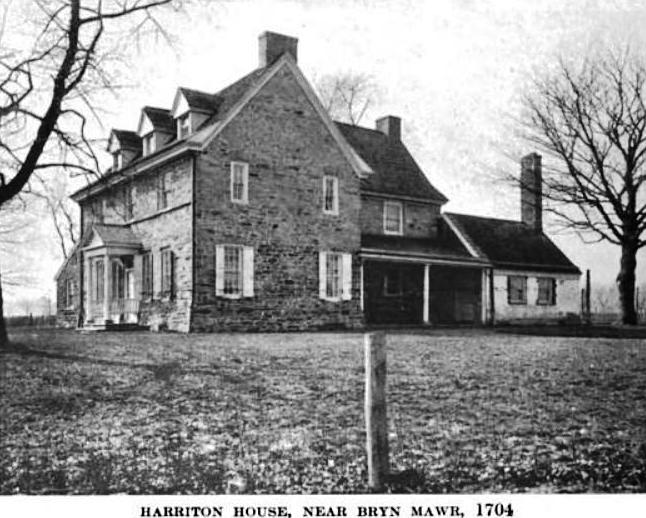
Harriton House
Monument and historic site · National Register of Historic Places · 3.0 mi
Originally Bryn Mawr, historic house in Bryn Mawr, Pennsylvania, United States

Hovenden House, Barn and Abolition Hall
Monument and historic site · National Register of Historic Places · 2.2 mi
Historic complex in Pennsylvania, United States

Idlewild Farm Complex
Monument and historic site · National Register of Historic Places · 2.9 mi
Building in Pennsylvania, United States

Joseph Sinnott Mansion
Monument and historic site · National Register of Historic Places · 3.3 mi
Building in Pennsylvania, United States


Lee Tire and Rubber Company
Monument and historic site · National Register of Historic Places · 0.8 mi
Building in Pennsylvania, United States
10 more on the map.
Parks, trails and playgrounds23


Riverbend Environmental Education Center
Hiking and trails · 1.2 mi
1950 North Spring Mill Road, Lower Merion Township


Wissahickon Ski Club
Sports field and stadium · 1.6 mi
265 Barren Hill Road, Conshohocken
11 more on the map.
Restaurants and cafes59

Chiangmai
Restaurant · Thai
108 Fayette Street, Conshohocken
Mo,Su 15:30-20:30; Tu-Th 11:30-20:30; Fr-Sa 11:30-21:30
Dragon & Phoenix Express
Restaurant · Chinese
515 Fayette Street, Conshohocken
Mo-Th 11:00-22:00; Fr-Sa 11:00-23:00; Su 12:30-22:00
Fingers Wings & Other Things
Restaurant · Chicken · 1.4 mi
107 West Ridge Pike, Conshohocken
Mo-Th 11:00-22:00; Fr-Sa 11:00-23:00; Su 11:00-21:00

Flanigan's Boat House
Diner · American
113 Fayette Street, Conshohocken
Mo off; Tu,Su 11:00-22:00; We-Th 11:00-23:00; Fr-Sa 11:00-24:00
Franzone's Pizzeria
Restaurant · Pizza · 1.4 mi
1940 Main Avenue, Conshohocken
Mo-Fr 08:00-23:00; Sa 10:00-23:00; Su 11:00-22:00
III Illiano's Pizza
Restaurant · Pizza · 1.5 mi
24 East Ridge Pike, Conshohocken
Mo-Sa 10:00-21:00; Su 11:30-21:00
Jasper's Backyard
Diner · American
101 East 7th Avenue, Conshohocken
Mo 16:00-21:00; Tu-We 11:30-21:00; Th-Sa 11:30-22:00; Su 10:00-21:00
Little Brew House
Diner · American · 1.4 mi
214 West Ridge Pike, Conshohocken
Mo off; Tu-Th 12:00-21:00; Fr-Sa 12:00-22:00; Su 12:00-20:00
Mezeh Mediterranean Grill
Restaurant · Mediterranean · 1.5 mi
48 East Ridge Pike, Conshohocken
10:30-22:00
Outback Steakhouse
Restaurant · American, Steak · 1.4 mi
322 West Ridge Pike, Conshohocken
Mo-Th 11:00-21:30; Fr-Sa 11:00-22:30; Su 11:00-21:00

47 more on the map.
Where to stay3
Hotel West & Main Conshohocken Philadelphia, Tapestry Collection by Hilton
Motel and hotel
46 Fayette Street, Conshohocken
Churches and places of worship15
Plymouth Friends Meetinghouse
Church · National Register of Historic Places · 2.1 mi
Heart of Truth Ministries
Church · Nondenominational · 0.9 mi
334 Summit Avenue, Conshohocken
Shopping4
Gas and EV charging12
Schools, colleges and libraries45
Healthcare2
Map of Conshohocken
191 places. The map loads OpenStreetMap tiles when you open it.
Climate by month
Monthly table
| Month | High | Low | Rain | Snow |
|---|---|---|---|---|
| Jan | 42°F | 23°F | 3.7 in | 6.8 in |
| Feb | 44°F | 25°F | 3.0 in | 10.9 in |
| Mar | 52°F | 32°F | 4.4 in | 3.0 in |
| Apr | 65°F | 42°F | 3.9 in | 0.2 in |
| May | 75°F | 52°F | 4.2 in | 0.0 in |
| Jun | 84°F | 62°F | 4.2 in | 0.0 in |
| Jul | 89°F | 67°F | 4.7 in | 0.0 in |
| Aug | 86°F | 65°F | 5.0 in | 0.0 in |
| Sep | 80°F | 58°F | 4.9 in | 0.0 in |
| Oct | 68°F | 45°F | 4.3 in | 0.1 in |
| Nov | 57°F | 35°F | 3.6 in | 0.1 in |
| Dec | 46°F | 28°F | 4.7 in | 4.2 in |
U.S. Climate Normals 1991-2020 for Norristown (3 mi away), NOAA NCEI.
People and cost of living
American Community Survey 5-year estimates, 2020-2024, U.S. Census Bureau. Estimates have margins of error, larger for small towns.
Disaster history
Montgomery County has had 19 federal disaster declarations since 2000, most often for hurricanes.
- 2021-09-10: Remnants Of Hurricane Ida (Hurricane)
- 2020-03-30: Covid-19 Pandemic (Biological)
- 2020-03-13: Covid-19 (Biological)
- 2016-03-23: Severe Winter Storm And Snowstorm (Snowstorm)
- 2014-02-06: Severe Winter Storm (Severe Ice Storm)
- 2013-01-10: Hurricane Sandy (Hurricane)
OpenFEMA disaster declarations summaries.
Getting there and nearby towns
Wings Field (BBX) is the nearest airport with scheduled flights listed in OpenStreetMap, 4 miles away.
- West Conshohocken 1 mi southwest, about 1 min by car
- Swedeland 2 mi northwest, about 3 min by car
- Plymouth Meeting 3 mi northeast, about 4 min by car
- Bridgeport 3 mi northwest, about 4 min by car
- Rosemont 3 mi south, about 6 min by car
- Norristown 4 mi northwest, about 6 min by car
- King of Prussia 4 mi west, about 7 min by car
- Bryn Mawr 4 mi south, about 6 min by car
- St. Davids 5 mi southwest, about 7 min by car
- Ardmore 5 mi south, about 8 min by car
Drive times are estimates from straight-line distance, not routes.
Local news
Headlines from INDB, the NEMICO news database.
Reviews, tips and questions
Loading what members have shared...
Sources and licences
- NCES EDGE (Public domain): public schools
- NOAA NCEI U.S. Climate Normals 1991-2020 (Public domain): climate by month
- OpenFEMA (Public domain): disaster declarations
- OpenStreetMap contributors (ODbL 1.0): places, airports, map data
- U.S. Census Bureau (Public domain): population, income, housing, education, commute
- Wikidata (CC0 1.0): elevation, founding date, time zone, website, landmarks and historic places
- Wikimedia Commons (see each image): photos
- Wikipedia (CC BY-SA 4.0): overview and history text
Photo credits
- Conshohocken Riverfront, Montgomery County Planning Commission, CC BY-SA 2.0
- Mount Joy Conshohocken PA, Smallbones, CC0
- Hovenden House from SW 2016, BoringHistoryGuy, CC BY-SA 3.0
- Bridge in Upper Merion Township 01, Shuvaev, CC BY-SA 3.0
- Millers House Conshohocken PA, Smallbones, CC0
- PlymouthMeetinghouseMontgomeryCountyPennsylvania, Jack E. Boucher, HABS photographer., Public domain
- Plymouth Meeting Country Store & Post Office 2016, BoringHistoryGuy, CC BY-SA 4.0
- Poplar Lane 1, Hshuvaeva, CC BY-SA 3.0
- Rosemont81, Midnightdreary at en.wikipedia, Public domain
- Alan West Corson Homestead 2, Hshuvaeva, CC BY-SA 3.0
- Globe Knitting Noristown PA, Smallbones, CC0
- Lee Tire Conshohocken PA, Smallbones, CC0
- Gladwyne HD 1 Guard House, Hshuvaeva, CC BY-SA 3.0
- Idlewild 1 MontCo PA, Smallbones, CC BY-SA 3.0
- Washington Hose Montco PA, Smallbones, CC0
- Cold Point Baptist Montco PA HD, Smallbones, CC0
- Norristown PA Castle, Smallbones, CC0
- Harriton House 1919, John Thomson Faris, Public domain
- UPPER ROXBOROUGH HISTORIC DISTRICT, MONTGOMERY COUNTY, PA, Jerrye & Roy Klotz, MD, CC BY-SA 3.0


Page built October 30, 2026. Spotted a mistake? Tell us or suggest a place.