


Bryn Mawr, Pennsylvania
Bryn Mawr is a community of 5,880 people in Delaware County, Pennsylvania, founded in 1681.
Why visit Bryn Mawr
Townapedia lists 28 museums and landmarks, 30 parks and trails, 49 places to eat and 7 attractions in and around town.
Highlights include Bridge in Radnor Township No. 2, Bryn Mawr Film Institute, Old Library and Allgates.
July is the warmest month, with average highs of 89°F; January lows average 23°F, and about 25 inches of snow fall in a normal year.
Weather in Bryn Mawr
Forecast from the National Weather Service. Full forecast
About Bryn Mawr
Bryn Mawr ( brin MAR; from Welsh for 'big hill', IPA: [brɨn ˈmaur]) is a census-designated place (CDP) located in Delaware County, Pennsylvania, United States. It is located just west of Philadelphia along Lancaster Avenue, also known as U.S. Route 30. As of 2020, the CDP is defined to include sections of Lower Merion Township, Montgomery County, as well as portions of Haverford Township and Radnor Township.
From the Wikipedia article Bryn Mawr, Pennsylvania (this version), under CC BY-SA 4.0.
Things to do7

Bridge in Radnor Township No. 2
Bridge · National Register of Historic Places · 1.6 mi
Bridge in United States of America


Bryn Mawr College
School · 0.4 mi
Liberal arts college in Pennsylvania, US


Villanova University
School · 1.6 mi
Catholic university near Philadelphia, Pennsylvania
Museums and landmarks28

Old Library
Monument and historic site · National Register of Historic Places · 0.4 mi
Historic building on Bryn Mawr College Campus

Allgates
Monument and historic site · National Register of Historic Places · 1.7 mi
House in Haverford Township, Pennsylvania

Baldwin School
Monument and historic site · National Register of Historic Places
Private school for girls in Bryn Mawr, Pennsylvania, United States

Bridge in Radnor Township No. 1
Bridge · National Register of Historic Places · 3.2 mi
Bridge in United States of America

Camp-Woods
Monument and historic site · National Register of Historic Places · 2.5 mi
Building in Pennsylvania, United States

Federal School
Monument and historic site · National Register of Historic Places · 1.8 mi
Human settlement in Pennsylvania, United States of America

General Wayne Inn
Monument and historic site · National Register of Historic Places · 3.4 mi
Inn in Pennsylvania, United States of America

Gladwyne Historic District
Monument and historic site · National Register of Historic Places · 2.2 mi
Historic district in Pennsylvania, United States

Glenays
Monument and historic site · National Register of Historic Places · 1.0 mi
Historic house in Pennsylvania, United States
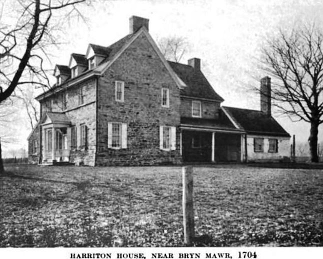
Harriton House
Monument and historic site · National Register of Historic Places · 1.0 mi
Originally Bryn Mawr, historic house in Bryn Mawr, Pennsylvania, United States

Idlewild Farm Complex
Monument and historic site · National Register of Historic Places · 1.6 mi
Building in Pennsylvania, United States


Joseph Sinnott Mansion
Monument and historic site · National Register of Historic Places · 1.1 mi
Building in Pennsylvania, United States
16 more on the map.
Parks, trails and playgrounds30



Vernon V. Young Memorial Park
Park · 1.3 mi
Basketball, softball, baseball, tennis courts (illuminated), volleyball, children’s playground, comfort station, tot lot, swimming pool,...
124 Ardmore Avenue
18 more on the map.
Restaurants and cafes49



Gullifty's
Diner · American · 0.6 mi
1149 Lancaster Avenue, Rosemont
Mo-Sa 11:30-22:00; Su 11:30-21:00

La Colombe Coffee Roasters
Cafe · Coffee Shop
915 West Lancaster Avenue
Mo-Fr 06:30-18:00; Sa-Su 07:00-18:00
Little Basil
Restaurant · Asian · 1.2 mi
906 Conestoga Road, Rosemont
Tu-Sa 11:00-22:00; Su 12:00-22:00
Positano Ristorante
Restaurant · Italian · 1.5 mi
21 West Lancaster Avenue, Ardmore
Mo-Tu off; We-Th 17:00-21:30; Fr-Sa 17:00-22:00; Su 16:00-21:30
Snap Custom Pizza
Restaurant · Pizza · 0.5 mi
1125 West Lancaster Avenue
Mo-Th,Su 11:00-22:00; Fr-Sa 11:00-23:00
Sub Valley Pizza and Catering
Restaurant · Pizza
602 Lancaster Avenue, Bryn Mawr
Mo-Sa 10:00-19:00; Su 11:30-19:00
37 more on the map.
History
Bryn Mawr is named after an estate near Dolgellau in Wales that belonged to Rowland Ellis, a Welsh Quaker who emigrated in 1686 to Pennsylvania to escape religious persecution. Here he built a replica of his home in Wales, which he also called Bryn Mawr.
Until the construction of the Pennsylvania Railroad's Main Line in 1869, the town, located in the old Welsh Tract, was known as Humphreysville, named for early settlers of the Humphreys family. The town was renamed, after Rowland Ellis's estate, by railroad agent William H. Wilson after he acquired on behalf of the railroad the 283 acres (1.15 km2) that now compose Bryn Mawr.
To encourage visitors the railroad constructed the Bryn Mawr Hotel adjacent to the new station, which opened in 1872. After a fire destroyed the original building, a distinctive new hotel designed by architect Frank Furness was built in 1889. The second hotel building is currently occupied by The Baldwin School and was added to the National Register of Historic Places in 1979.
Bryn Mawr College was founded in 1885 originally as a Quaker institution but by 1893, it had become non-denominational.
In 1893, the first hospital, Bryn Mawr Hospital, was built on the Main Line by Dr. George Gerhard. Glenays, a historic home dating to 1859, was listed on the National Register of Historic Places in 1977.
From the History section of Bryn Mawr, Pennsylvania on Wikipedia, under CC BY-SA 4.0.
Churches and places of worship18
Radnor Friends Meetinghouse
Church · National Register of Historic Places · 2.6 mi
Proclamation Presbyterian Church
Church · Presbyterian · 0.8 mi
278 South Bryn Mawr Avenue, Bryn Mawr
Haverford Friends Meeting House
Church · Quaker · 0.6 mi
855 Buck Lane, Haverford
Shopping11
Gas and EV charging6
Schools, colleges and libraries64
Healthcare7
Claytor Noone Plastic Surgery: Dr. R. Brannon Claytor
Clinic and pharmacy
135 South Bryn Mawr Avenue, Bryn Mawr
Map of Bryn Mawr
220 places. The map loads OpenStreetMap tiles when you open it.
Climate by month
Monthly table
| Month | High | Low | Rain | Snow |
|---|---|---|---|---|
| Jan | 42°F | 23°F | 3.7 in | 6.8 in |
| Feb | 44°F | 25°F | 3.0 in | 10.9 in |
| Mar | 52°F | 32°F | 4.4 in | 3.0 in |
| Apr | 65°F | 42°F | 3.9 in | 0.2 in |
| May | 75°F | 52°F | 4.2 in | 0.0 in |
| Jun | 84°F | 62°F | 4.2 in | 0.0 in |
| Jul | 89°F | 67°F | 4.7 in | 0.0 in |
| Aug | 86°F | 65°F | 5.0 in | 0.0 in |
| Sep | 80°F | 58°F | 4.9 in | 0.0 in |
| Oct | 68°F | 45°F | 4.3 in | 0.1 in |
| Nov | 57°F | 35°F | 3.6 in | 0.1 in |
| Dec | 46°F | 28°F | 4.7 in | 4.2 in |
U.S. Climate Normals 1991-2020 for Norristown (6 mi away), NOAA NCEI.
People and cost of living
American Community Survey 5-year estimates, 2020-2024, U.S. Census Bureau. Estimates have margins of error, larger for small towns.
Disaster history
Delaware County has had 15 federal disaster declarations since 2000, most often for hurricanes.
- 2021-09-10: Remnants Of Hurricane Ida (Hurricane)
- 2020-03-30: Covid-19 Pandemic (Biological)
- 2020-03-13: Covid-19 (Biological)
- 2014-02-06: Severe Winter Storm (Severe Ice Storm)
- 2012-10-29: Hurricane Sandy (Hurricane)
- 2011-09-12: Tropical Storm Lee (Flood)
OpenFEMA disaster declarations summaries.
Getting there and nearby towns
Wings Field (BBX) is the nearest airport with scheduled flights listed in OpenStreetMap, 9 miles away.
- Haverford College 1 mi southeast, about 1 min by car
- Ardmore 2 mi southeast, about 3 min by car
- West Conshohocken 3 mi north, about 6 min by car
- Broomall 4 mi southwest, about 7 min by car
- Drexel Hill 5 mi south, about 8 min by car
- Bala Cynwyd 5 mi east, about 8 min by car
- Swedeland 5 mi north, about 8 min by car
- Millbourne 5 mi southeast, about 8 min by car
- King of Prussia 6 mi northwest, about 10 min by car
- Lansdowne 6 mi south, about 10 min by car
Drive times are estimates from straight-line distance, not routes.
Local news
Headlines from INDB, the NEMICO news database.
Reviews, tips and questions
Loading what members have shared...
Sources and licences
- NCES EDGE (Public domain): public schools
- NOAA NCEI U.S. Climate Normals 1991-2020 (Public domain): climate by month
- OpenFEMA (Public domain): disaster declarations
- OpenStreetMap contributors (ODbL 1.0): places, airports, map data
- U.S. Census Bureau (Public domain): population, income, housing, education, commute
- Wikidata (CC0 1.0): elevation, founding date, time zone, website, landmarks and historic places
- Wikimedia Commons (see each image): photos
- Wikipedia (CC BY-SA 4.0): overview and history text
Photo credits
- Taxi at Bryn Mawr station, April 2013, Montgomery County Planning Commission, CC BY-SA 2.0
- Bryn Mawr station at night, December 2013, Montgomery County Planning Commission, CC BY-SA 2.0
- Bryn Mawr 1872, Unknown engraver, Public domain
- Bryn Mawr Station 1875, Unknown author Unknown author, Public domain
- Bryn Mawr (Train Station) (9322765610), Library Company of Philadelphia, No restrictions
- Bryn Mawr station, Ii2nmd, CC0
- Bryn Mawr, PA SEPTA Station (2011), Centpacrr at English Wikipedia, CC BY-SA 3.0
- Bryn Mawr. Alternate Title: Scenery of the Pennsylvania Railroad., Purviance, W. T. (William T.) -- Photographer, Public domain
- Bryn Mawr. Alternate Title: Scenery of the Pennsylvania Railroad., Purviance, W. T. (William T.) -- Photographer, Public domain
- Bryn Mawr Post Office, Cornflower123, CC0
- Bryn Mawr Station 2011, Centpacrr at English Wikipedia, CC BY-SA 3.0
- Former Bryn Mawr Elementary School, Montgomery County Planning Commission, CC BY-SA 2.0
- Old Bryn Mawr School, Montgomery County Planning Commission, CC BY-SA 2.0
- Bryn Mawr Hotel, Smallbones, Public domain
- Great Hall Bryn Mawr College PA, Smallbones, CC0
- Bryn Mawr Hospital, Montgomery County Planning Commission, CC BY-SA 2.0
- Bryn Mawr Hospital 2, Montgomery County Planning Commission, CC BY-SA 2.0
- Bryn Mawr College Cloisters, Jeffrey M. Vinocur, CC BY 2.5
- NitreHall, User:Smallbones on English Wikipedia., Public domain
- Glenays, User:Smallbones on English Wikipedia., Public domain
- 750 Mill Creek Rd MontCo PA, Smallbones, CC BY-SA 3.0
- Harriton House 1919, John Thomson Faris, Public domain
- Bridge2Radnor, User:Smallbones at English Wikipedia., Public domain
- FederalSchool, User:Smallbones on English Wikipedia., Public domain
- GoshenRoadBridge, User:Smallbones ., Public domain
- Camp-Woods, Fearless LeChien, CC BY-SA 4.0
- Allgates, User:Smallbones on English Wikipedia., Public domain
- Rosemont81, Midnightdreary at en.wikipedia, Public domain
- RadnorFriendsMeetinghouse, User:Smallbones on English Wikipedia., Public domain
- General Wayne Inn PA, Smallbones, CC0
- Merion 1, Mark E. Wangerin on English Wikipedia., Public domain
- Pont Reading133671pu, HABS, Public domain
- Whitehall PA apartments NRHP, Smallbones, Public domain
- Merion Friends Meeting House, 615 Montgomery Avenue (changed from Montgomery Avenue & Meetinghouse Lane), Merion Station (Montgomery County, Pennsylvania), Unknown author Unknown author, Public domain
- 18 Narbrook Montco PA, Smallbones, CC0
- Gladwyne HD 1 Guard House, Hshuvaeva, CC BY-SA 3.0
- Idlewild 1 MontCo PA, Smallbones, CC BY-SA 3.0
- Bell Tower, Church of the Good Shepherd (Rosemont, Pennsylvania), Scribley, CC BY-SA 4.0
- Haverfordfounders, Jackbauerinvc ( talk ), CC BY-SA 3.0
- Entrance Bryn Mawr, Smallbones, Public domain


Page built October 30, 2026. Spotted a mistake? Tell us or suggest a place.