



West Conshohocken, Pennsylvania
West Conshohocken is a borough of 1,536 people in Montgomery County, Pennsylvania, founded in 1874.
Why visit West Conshohocken
Townapedia lists 23 museums and landmarks, 17 parks and trails, 39 places to eat, 3 places to stay and 7 attractions in and around town.
Highlights include Bryn Mawr College, Diamond Run Viaduct, Baldwin School and Bridge in Upper Merion Township.
July is the warmest month, with average highs of 89°F; January lows average 23°F, and about 25 inches of snow fall in a normal year.
Weather in West Conshohocken
Forecast from the National Weather Service. Full forecast
About West Conshohocken
West Conshohocken is a borough in Montgomery County, Pennsylvania, United States. As of the 2020 census, West Conshohocken had a population of 1,493.
From the Wikipedia article West Conshohocken, Pennsylvania (this version), under CC BY-SA 4.0.
Things to do7

Bryn Mawr College
School · 3.0 mi
Liberal arts college in Pennsylvania, US

Diamond Run Viaduct
Bridge · 2.3 mi
Bridge in United States of America

Eastern University
School · 3.0 mi
Christian educational institution in Pennsylvania, U.S.

Fayette Street Bridge
Bridge · 0.5 mi
Road bridge over the Schuylkill River in Montgomery County, Pennsylvania

Pearl Harbor Memorial Bridge
Bridge · 0.6 mi
Bridge in West Conshohocken and Connaughtown

Schuylkill River Bridge
Bridge · 2.3 mi
Bridge in United States of America

Villanova University
School · 2.5 mi
Catholic university near Philadelphia, Pennsylvania
Museums and landmarks23

Baldwin School
Monument and historic site · National Register of Historic Places · 3.3 mi
Private school for girls in Bryn Mawr, Pennsylvania, United States

Bridge in Upper Merion Township
Monument and historic site · National Register of Historic Places · 1.2 mi
Bridge in Pennsylvania, United States

Gladwyne Historic District
Monument and historic site · National Register of Historic Places · 3.1 mi
Historic district in Pennsylvania, United States

Globe Knitting Mills
Monument and historic site · National Register of Historic Places · 2.9 mi
Building in Pennsylvania, United States
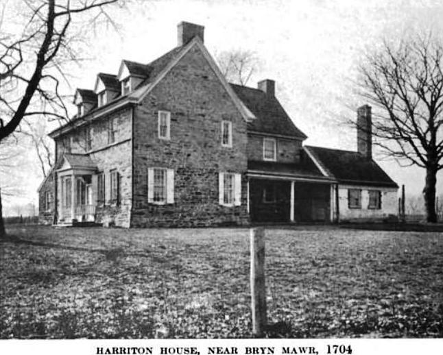
Harriton House
Monument and historic site · National Register of Historic Places · 2.5 mi
Originally Bryn Mawr, historic house in Bryn Mawr, Pennsylvania, United States

Hovenden House, Barn and Abolition Hall
Monument and historic site · National Register of Historic Places · 3.1 mi
Historic complex in Pennsylvania, United States

Idlewild Farm Complex
Monument and historic site · National Register of Historic Places · 2.7 mi
Building in Pennsylvania, United States

Joseph Sinnott Mansion
Monument and historic site · National Register of Historic Places · 2.6 mi
Building in Pennsylvania, United States

Lee Tire and Rubber Company
Monument and historic site · National Register of Historic Places · 1.7 mi
Building in Pennsylvania, United States

Miller's House at Spring Mill
Monument and historic site · National Register of Historic Places · 1.7 mi
Historic house in Pennsylvania, United States

Mount Joy
Monument and historic site · National Register of Historic Places · 1.8 mi
Building in Pennsylvania, United States


Old Library
Monument and historic site · National Register of Historic Places · 3.0 mi
Historic building on Bryn Mawr College Campus
11 more on the map.
Parks, trails and playgrounds17



5 more on the map.
Restaurants and cafes39

Chiangmai
Restaurant · Thai · 0.7 mi
108 Fayette Street, Conshohocken
Mo,Su 15:30-20:30; Tu-Th 11:30-20:30; Fr-Sa 11:30-21:30
Dragon & Phoenix Express
Restaurant · Chinese · 1.0 mi
515 Fayette Street, Conshohocken
Mo-Th 11:00-22:00; Fr-Sa 11:00-23:00; Su 12:30-22:00

Flanigan's Boat House
Diner · American · 0.7 mi
113 Fayette Street, Conshohocken
Mo off; Tu,Su 11:00-22:00; We-Th 11:00-23:00; Fr-Sa 11:00-24:00
Jasper's Backyard
Diner · American · 1.1 mi
101 East 7th Avenue, Conshohocken
Mo 16:00-21:00; Tu-We 11:30-21:00; Th-Sa 11:30-22:00; Su 10:00-21:00
Tony & Joe's Pizzeria
Restaurant · Pizza · 0.8 mi
201 Fayette Street, Conshohocken
Mo-Th 11:00-21:00; Fr-Sa 11:00-22:00; Su 12:00-21:00


Great American Pub
Bar and pub · 0.8 mi
123 Fayette Street, Conshohocken
Mo-Th,Su 11:30-21:00; Fr-Sa 11:30-22:00
Guppy's Good Times
Bar and pub · 0.6 mi
2 Maple Street, Conshohocken
Mo-We 11:30-22:00; Th 11:30-24:00; Fr 11:30-02:00; Sa 12:00-02:00;...
Morning Talk Cafe
Cafe · 0.7 mi
108 1/2 Fayette Street, Conshohocken
Mo off; Tu-Fr 07:00-16:00; Sa 07:05-15:55; Su 08:15-14:55
27 more on the map.
History
West Conshohocken was incorporated October 6, 1874, from land taken almost equally from Lower and Upper Merion Townships. The area's original name had been Balligomingo. As a river borough, there were a large number of mills and other industries utilizing water power. Dougherty Quarry was a prosperous business, producing stone of superior quality known as Conshohocken or Merion Blue. It was much sought after for public buildings, and was shipped by rail throughout the East Coast before supplies were exhausted in the mid-20th century.
With its proximity to highways I-76 and I-476, also known as the Blue Route, West Conshohocken and its sister Conshohocken have experienced moderate office and retail development. West Conshohocken has mid and high-rise commercial development along its waterfront, which in recent years has also spread across the river to Conshohocken's waterfront.
From the History section of West Conshohocken, Pennsylvania on Wikipedia, under CC BY-SA 4.0.
Where to stay3
Hotel West & Main Conshohocken Philadelphia, Tapestry Collection by Hilton
Motel and hotel · 0.6 mi
46 Fayette Street, Conshohocken
Churches and places of worship18
Plymouth Friends Meetinghouse
Church · National Register of Historic Places · 3.0 mi
Shopping1
Gas and EV charging7
Schools, colleges and libraries46
Map of West Conshohocken
161 places. The map loads OpenStreetMap tiles when you open it.
Climate by month
Monthly table
| Month | High | Low | Rain | Snow |
|---|---|---|---|---|
| Jan | 42°F | 23°F | 3.7 in | 6.8 in |
| Feb | 44°F | 25°F | 3.0 in | 10.9 in |
| Mar | 52°F | 32°F | 4.4 in | 3.0 in |
| Apr | 65°F | 42°F | 3.9 in | 0.2 in |
| May | 75°F | 52°F | 4.2 in | 0.0 in |
| Jun | 84°F | 62°F | 4.2 in | 0.0 in |
| Jul | 89°F | 67°F | 4.7 in | 0.0 in |
| Aug | 86°F | 65°F | 5.0 in | 0.0 in |
| Sep | 80°F | 58°F | 4.9 in | 0.0 in |
| Oct | 68°F | 45°F | 4.3 in | 0.1 in |
| Nov | 57°F | 35°F | 3.6 in | 0.1 in |
| Dec | 46°F | 28°F | 4.7 in | 4.2 in |
U.S. Climate Normals 1991-2020 for Norristown (3 mi away), NOAA NCEI.
People and cost of living
American Community Survey 5-year estimates, 2020-2024, U.S. Census Bureau. Estimates have margins of error, larger for small towns.
Disaster history
Montgomery County has had 19 federal disaster declarations since 2000, most often for hurricanes.
- 2021-09-10: Remnants Of Hurricane Ida (Hurricane)
- 2020-03-30: Covid-19 Pandemic (Biological)
- 2020-03-13: Covid-19 (Biological)
- 2016-03-23: Severe Winter Storm And Snowstorm (Snowstorm)
- 2014-02-06: Severe Winter Storm (Severe Ice Storm)
- 2013-01-10: Hurricane Sandy (Hurricane)
OpenFEMA disaster declarations summaries.
Getting there and nearby towns
Wings Field (BBX) is the nearest airport with scheduled flights listed in OpenStreetMap, 6 miles away.
- Swedeland 1 mi northwest, about 2 min by car
- King of Prussia 4 mi northwest, about 6 min by car
- Norristown 4 mi north, about 6 min by car
- Haverford College 4 mi south, about 7 min by car
- Ardmore 5 mi south, about 8 min by car
- Bala Cynwyd 6 mi southeast, about 10 min by car
- Broomall 7 mi south, about 12 min by car
- Drexel Hill 8 mi south, about 13 min by car
- Lansdowne 9 mi south, about 15 min by car
- Philadelphia 11 mi southeast, about 17 min by car
Drive times are estimates from straight-line distance, not routes.
Local news
Headlines from INDB, the NEMICO news database.
Reviews, tips and questions
Loading what members have shared...
Sources and licences
- NCES EDGE (Public domain): public schools
- NOAA NCEI U.S. Climate Normals 1991-2020 (Public domain): climate by month
- OpenFEMA (Public domain): disaster declarations
- OpenStreetMap contributors (ODbL 1.0): places, airports, map data
- U.S. Census Bureau (Public domain): population, income, housing, education, commute
- Wikidata (CC0 1.0): elevation, founding date, time zone, website, landmarks and historic places
- Wikimedia Commons (see each image): photos
- Wikipedia (CC BY-SA 4.0): overview and history text
Photo credits
- West Conshohocken Borough Hall, Ryan91, Public domain
- Harriton House 1919, John Thomson Faris, Public domain
- Bryn Mawr College Cloisters, Jeffrey M. Vinocur, CC BY 2.5
- Hovenden House from SW 2016, BoringHistoryGuy, CC BY-SA 3.0
- Bridge in Upper Merion Township 01, Shuvaev, CC BY-SA 3.0
- Millers House Conshohocken PA, Smallbones, CC0
- PlymouthMeetinghouseMontgomeryCountyPennsylvania, Jack E. Boucher, HABS photographer., Public domain
- CabriniWoodruff, User:Smallbones on English Wikipedia., Public domain
- Poplar Lane 1, Hshuvaeva, CC BY-SA 3.0
- Rosemont81, Midnightdreary at en.wikipedia, Public domain
- Seville Theater exterior, Smallbones, Public domain
- Mount Joy Conshohocken PA, Smallbones, CC0
- Globe Knitting Noristown PA, Smallbones, CC0
- Lee Tire Conshohocken PA, Smallbones, CC0
- Gladwyne HD 1 Guard House, Hshuvaeva, CC BY-SA 3.0
- Idlewild 1 MontCo PA, Smallbones, CC BY-SA 3.0
- Washington Hose Montco PA, Smallbones, CC0
- Villanova Church, abbike18, CC BY-SA 3.0
- Bell Tower, Church of the Good Shepherd (Rosemont, Pennsylvania), Scribley, CC BY-SA 4.0
- Coptic Church Norristown PA, Sally from Norristown, PA, USA, CC BY 2.0
- Bryn Mawr PA Presby PHS088, Unknown author Unknown author, Public domain
- Entrance Bryn Mawr, Smallbones, Public domain
- Pearl Harbor Memorial Bridge, Ii2nmd, CC BY-SA 4.0
- Schuylkill River Bridge, Ii2nmd, CC BY-SA 4.0
- Fayette Street Bridge, Ii2nmd, CC BY-SA 4.0


Page built October 30, 2026. Spotted a mistake? Tell us or suggest a place.