


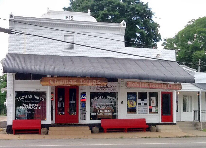
Cross Plains, Tennessee
Cross Plains is a city of 1,922 people in Robertson County, Tennessee, founded in 1819.
Why visit Cross Plains
Townapedia lists 5 museums and landmarks, 1 park or trail, 2 places to eat and 6 attractions in and around town.
Highlights include Bradley Hill, Cherry Mount Hill, Rock Jolly and Thomas Drugs.
July is the warmest month, with average highs of 89°F; January lows average 27°F.
Weather in Cross Plains
Forecast from the National Weather Service. Full forecast
About Cross Plains
Cross Plains is a city in Robertson County, Tennessee. The city's population was 1,789 at the 2020 census. Cross Plains was the first area of Robertson County that was settled by European settlers, with the arrival of Thomas Kilgore in 1778.
From the Wikipedia article Cross Plains, Tennessee (this version), under CC BY-SA 4.0.
Things to do6

Museums and landmarks5

Rock Jolly
Monument and historic site · National Register of Historic Places · 4.0 mi
Historic house near Cross Plains, Tennessee, United States

Thomas Drugs
Monument and historic site · National Register of Historic Places · 1.2 mi
Drug store located in Cross Plains, Tennessee


Walton–Wiggins Farm
Monument and historic site · National Register of Historic Places · 3.5 mi
Historic farm in Tennessee, United States
William Randolph House
Monument and historic site · National Register of Historic Places · 1.3 mi
Cross Plains, Tennessee, listed on the NRHP in Robertson County
Parks, trails and playgrounds1

Restaurants and cafes2

History
In 1778, American Revolutionary War veteran Thomas Kilgore arrived at the Middle Fork of Red River, three-fourths of a mile west of Cross Plains, making him the first European settler to arrive in Robertson County. Kilgore traveled to this area to claim 640 acres of land, which was guaranteed to settlers who traveled west by the Legislature of North Carolina. Kilgore returned to eastern North Carolina in the fall of 1778, and after the title of his land was confirmed, he traveled back to his settlement with a few other families, and built a stockade which would be known as Kilgore Station. The first building was a double log house erected by William Randolph in 1819. It was also used as a tavern.
In 1873, J.M. Walton established Neophogen College, a private university which operated until 1877. Thomas Drugs opened in 1915; it is one of the oldest establishments in Cross Plains.
In 2004, construction began on "Kilgore Park" located west of East Robertson High School. Construction was completed in 2008. In 2020, the Cross Plains city government announced that they had purchased 148 acres of land on Highway 25 west of Kilgore Park for $1.08 million. City officials stated that the land was purchased for future uses such as an expansion of Kilgore Park, or new schools.
From the History section of Cross Plains, Tennessee on Wikipedia, under CC BY-SA 4.0.
Churches and places of worship5
Shopping2
Gas and EV charging4
Schools, colleges and libraries9
Tennessee Connections Academy Johnson County 4-8
School · 4.9 mi
117 Edenway Dr, White House
Tennessee Connections Academy Johnson County 9-12
School · 4.9 mi
117 Edenway Dr, White House
White House Heritage High School
School · 4.8 mi
7744 Highway 76 E Dr, White House
Map of Cross Plains
34 places. The map loads OpenStreetMap tiles when you open it.
Climate by month
Monthly table
| Month | High | Low | Rain |
|---|---|---|---|
| Jan | 46°F | 27°F | 4.2 in |
| Feb | 50°F | 29°F | 4.5 in |
| Mar | 59°F | 37°F | 4.9 in |
| Apr | 70°F | 46°F | 5.3 in |
| May | 78°F | 56°F | 5.7 in |
| Jun | 85°F | 64°F | 4.3 in |
| Jul | 89°F | 68°F | 4.8 in |
| Aug | 88°F | 66°F | 4.0 in |
| Sep | 82°F | 58°F | 3.9 in |
| Oct | 72°F | 48°F | 3.8 in |
| Nov | 59°F | 37°F | 4.1 in |
| Dec | 49°F | 31°F | 4.8 in |
U.S. Climate Normals 1991-2020 for White House (6 mi away), NOAA NCEI.
People and cost of living
American Community Survey 5-year estimates, 2020-2024, U.S. Census Bureau. Estimates have margins of error, larger for small towns.
Disaster history
Robertson County has had 11 federal disaster declarations since 2000, most often for severe storms.
- 2026-02-06: Severe Winter Storm (Winter Storm)
- 2026-01-24: Severe Winter Storm (Winter Storm)
- 2025-04-02: Severe Storms, Straight-Line Winds, Tornadoes, And Flooding (Severe Storm)
- 2023-12-13: Severe Storms And Tornadoes (Severe Storm)
- 2023-05-17: Severe Storms, Straight-Line Winds, And Tornado (Severe Storm)
- 2020-04-02: Covid-19 Pandemic (Biological)
OpenFEMA disaster declarations summaries.
Getting there and nearby towns
Nashville International Airport (BNA) is the nearest airport with scheduled flights listed in OpenStreetMap, 29 miles away.
- White House 5 mi south, about 9 min by car
- Portland 9 mi northeast, about 15 min by car
- Springfield 11 mi west, about 18 min by car
- Franklin 14 mi northeast, about 22 min by car
- Goodlettsville 15 mi south, about 23 min by car
- Gallatin 16 mi southeast, about 26 min by car
- Hendersonville 17 mi south, about 27 min by car
- Coopertown 18 mi southwest, about 29 min by car
- Mount Juliet 25 mi south, about 41 min by car
- Nashville-Davidson 26 mi south, about 42 min by car
Drive times are estimates from straight-line distance, not routes.
Local news
Headlines from INDB, the NEMICO news database.
Reviews, tips and questions
Loading what members have shared...
Sources and licences
- NCES EDGE (Public domain): public schools
- NOAA NCEI U.S. Climate Normals 1991-2020 (Public domain): climate by month
- OpenFEMA (Public domain): disaster declarations
- OpenStreetMap contributors (ODbL 1.0): places, airports, map data
- U.S. Census Bureau (Public domain): population, income, housing, education, commute
- Wikidata (CC0 1.0): elevation, founding date, time zone, website, landmarks and historic places
- Wikimedia Commons (see each image): photos
- Wikipedia (CC BY-SA 4.0): overview and history text
Photo credits
- Thomas Drugs in Cross Plains Tennessee 7272013, Ichabod, CC BY-SA 3.0
- Cross Plains, TN, USA - panoramio, Evan Nichols (Virtua…, CC BY 3.0
- William Randolph House, MissDashwood, CC BY-SA 3.0
- Walton-Wiggins Farm, Wingerham52, CC BY-SA 4.0
- Rock Jolly, rossograph, CC BY-SA 4.0
- Thomas Drugs, MissDashwood, CC BY-SA 3.0
- East Robertson High school, BlueShirtz, CC BY-SA 4.0
- Interstate 65 South Construction, Paul Webb, CC BY-SA 4.0
- Tennessee25shieldcrop, Paul Webb, CC BY-SA 4.0


Page built October 30, 2026. Spotted a mistake? Tell us or suggest a place.