


Dayton, Minnesota
Dayton is a city of 9,095 people in Hennepin County, Minnesota, founded in 1855.
Why visit Dayton
Townapedia lists 23 museums and landmarks, 66 parks and trails, 84 places to eat, 13 places to stay and 2 attractions in and around town.
Highlights include Anoka–Champlin Mississippi River Bridge, Emagine Rogers, Anoka Post Office and Colonial Hall and Masonic Lodge No. 30.
July is the warmest month, with average highs of 83°F; January lows average 4°F, and about 36 inches of snow fall in a normal year.
Weather in Dayton
Forecast from the National Weather Service. Full forecast
About Dayton
Dayton is a city in Hennepin and Wright counties in the U.S. state of Minnesota. The population was 7,262 at the 2020 census. According to 2025 census estimates, the city is estimated to have a population of 11,402. Dayton is mainly located within Hennepin County, but a part of the city extends into Wright County as well.
From the Wikipedia article Dayton, Minnesota (this version), under CC BY-SA 4.0.
Things to do2

Anoka–Champlin Mississippi River Bridge
Bridge · National Register of Historic Places · 3.7 mi
Highway bridge across the Mississippi River between Anoka, Minnesota and Champlin, Minnesota

Emagine Rogers
Cinema and theater · 3.9 mi
13692 Rogers Drive, Rogers
Museums and landmarks23

Anoka Post Office
Monument and historic site · National Register of Historic Places · 4.2 mi
Former post office building in Anoka, Minnesota, United States

Colonial Hall and Masonic Lodge No. 30
Monument and historic site · National Register of Historic Places · 4.2 mi
House in Anoka, United States of America

District No. 28 School
Monument and historic site · National Register of Historic Places · 4.4 mi
Historic school building in Ramsey, Minnesota, United States

Hagel Family Farm
Monument and historic site · National Register of Historic Places · 5.2 mi
Human settlement in Rogers, Minnesota, United States of America

Heman L. Ticknor House
Monument and historic site · National Register of Historic Places · 4.1 mi
Historic house in Anoka, Minnesota, United States

Jackson Hotel
Monument and historic site · National Register of Historic Places · 4.1 mi
Listed on the National Register of Historic Places in Anoka County, Minnesota

Oliver H. Kelley Homestead
Monument and historic site · National Register of Historic Places · 5.8 mi
Human settlement in Sherburne County, Minnesota, United States of America
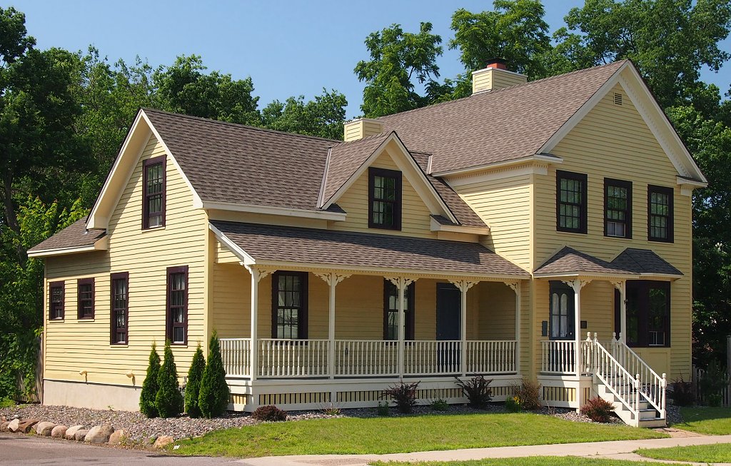
Shaw–Hammons House
Monument and historic site · National Register of Historic Places · 3.8 mi
Oldest standing residential building in Anoka, Minnesota, United States

Windego Park Auditorium/Open Air Theater
Monument and historic site · National Register of Historic Places · 3.9 mi
Amphitheatre in Anoka, United States of America


Osseo Water Tower
Monument and historic site · National Register of Historic Places · 5.8 mi

Pierre Bottineau House
Museum · 4.0 mi
Historic house museum in Maple Grove, Minnesota
11 more on the map.
Parks, trails and playgrounds66


Andrews Park (Champlin, Minnesota)
Park · 5.0 mi
Park in Minnesota, United States of America
Josephine Nunn Park
Park · 3.2 mi
12790 Monticello Lane North, Champlin
Mo-Su 06:00-22:00

Doris A. Kemp Park
Park · 3.9 mi
Pretty green park with flower beds, a picnic area & gazebo beside a fishing & boating lake.
921 HWY 169, Champlin
54 more on the map.
Restaurants and cafes84

Anoka Hardware Store
Bar and pub · Burger, Local, Tea · 4.1 mi
201 Jackson Street
We 16:00-22:00; Th 17:00-22:00; Fr 16:00-23:00; Sa 15:00-23:00

Chili Lime
Restaurant · Mexican, Tacos, Burrito, Comfort Food, Quick Bites · 3.9 mi
12490 Champlin Drive, Champlin
Mo-Su 11:00-20:00


10k Brewing
Brewery and winery · 4.0 mi
2005 2nd Avenue, Anoka
Mo-Tu 16:00-21:00; We-Th 15:00-22:00; Fr 13:00 - 23:00; Sa 12:00 -...
Ambi Wine Bar & Desserts
Restaurant · 4.0 mi
2015 2nd Avenue, Anoka
Tu-Th 16:00-22:00; Fr 15:00-23:00; Sa 12:00-23:00; Su 13:00-19:00
Apa Sushi
Restaurant · Sushi, Thai · 3.8 mi
15607 Grove Circle North
Tu-Fr 11:00-15:00, 16:30-21:30; Sa 12:00-21:30; Su 12:00-21:00
JR's Outpost
Bar and pub · 3.1 mi
6141 US 10, Ramsey
Mo-We 07:00-25:00; Th-Sa 07:00-26:00; Su 08:00-25:00
201 Tavern & Grill
Restaurant · 4.1 mi
201 Jackson Street, Anoka
Su-Th 11:00 - 23:00; Fr-Sa 11:00-25:00
72 more on the map.
Where to stay13
Holiday Inn Express & Suites
Motel and hotel · 3.7 mi
20930 135th Avenue North, Rogers
Churches and places of worship13
Northwood Community Church
Church · Baptist · 3.0 mi
16100 Arbor Ridge Parkway, Maple Grove
Redeeming Grace Lutheran Church ELS
Church · Lutheran · 3.0 mi
14077 Monarch Lane, Rogers
Word of Peace Lutheran Church ELCA
Church · Lutheran · 4.1 mi
21705 129th Avenue North, Rogers
Shopping16
Gas and EV charging15
Casey's General Store
Gas station · 3.3 mi
14131 Sunfish Lake Boulevard Northwest, Ramsey
Schools, colleges and libraries47
Healthcare12
Map of Dayton
250 places. The map loads OpenStreetMap tiles when you open it.
Climate by month
Monthly table
| Month | High | Low | Rain | Snow |
|---|---|---|---|---|
| Jan | 22°F | 4°F | 0.8 in | 8.2 in |
| Feb | 28°F | 7°F | 0.8 in | 7.3 in |
| Mar | 40°F | 18°F | 1.7 in | 6.3 in |
| Apr | 56°F | 32°F | 3.0 in | 2.4 in |
| May | 69°F | 44°F | 4.2 in | 0.0 in |
| Jun | 79°F | 56°F | 4.5 in | 0.0 in |
| Jul | 83°F | 61°F | 4.5 in | 0.0 in |
| Aug | 81°F | 58°F | 4.0 in | 0.0 in |
| Sep | 72°F | 49°F | 3.6 in | 0.0 in |
| Oct | 58°F | 36°F | 3.0 in | 0.2 in |
| Nov | 41°F | 24°F | 1.7 in | 5.3 in |
| Dec | 27°F | 11°F | 1.1 in | 6.0 in |
U.S. Climate Normals 1991-2020 for Elk Rvr (10 mi away), NOAA NCEI.
People and cost of living
American Community Survey 5-year estimates, 2020-2024, U.S. Census Bureau. Estimates have margins of error, larger for small towns.
Disaster history
Hennepin County has had 10 federal disaster declarations since 2000, most often for floods.
- 2020-04-07: Covid-19 Pandemic (Biological)
- 2020-03-13: Covid-19 (Biological)
- 2016-11-02: Severe Storms And Flooding (Flood)
- 2014-07-21: Severe Storms, Straight-Line Winds, Flooding, Landslides, And Mudslides (Flood)
- 2013-07-25: Severe Storms, Straight-Line Winds, And Flooding (Severe Storm)
- 2011-06-07: Severe Storms And Tornadoes (Severe Storm)
OpenFEMA disaster declarations summaries.
Getting there and nearby towns
Crystal Airport (MIC) is the nearest airport with scheduled flights listed in OpenStreetMap, 11 miles away.
- Champlin 4 mi east, about 7 min by car
- Anoka 4 mi northeast, about 7 min by car
- Maple Grove 5 mi south, about 8 min by car
- Ramsey 5 mi north, about 8 min by car
- Rogers 5 mi west, about 8 min by car
- Coon Rapids 8 mi east, about 13 min by car
- Brooklyn Park 8 mi southeast, about 13 min by car
- Andover 8 mi northeast, about 13 min by car
- Corcoran 8 mi southwest, about 12 min by car
- Otsego 9 mi northwest, about 15 min by car
Drive times are estimates from straight-line distance, not routes.
Local news
Headlines from INDB, the NEMICO news database.
Reviews, tips and questions
Loading what members have shared...
Sources and licences
- NCES EDGE (Public domain): public schools
- NOAA NCEI U.S. Climate Normals 1991-2020 (Public domain): climate by month
- OpenFEMA (Public domain): disaster declarations
- OpenStreetMap contributors (ODbL 1.0): places, airports, map data
- U.S. Census Bureau (Public domain): population, income, housing, education, commute
- Wikidata (CC0 1.0): elevation, founding date, time zone, website, landmarks and historic places
- Wikimedia Commons (see each image): photos
- Wikipedia (CC BY-SA 4.0): overview and history text
Photo credits
- Dayton Catholic Church, 123dieinafire, Public domain
- Electrical Power Lines - Winter Farmland, Dayton, Minnesota (39658285192), Tony Webster from Minneapolis, Minnesota, United States, CC BY-SA 2.0
- Windego Park 1, Elkman, CC BY-SA 3.0
- Anoka-Champlin Bridge, McGhiever, CC BY 4.0
- Heman L. Ticknor House, McGhiever, CC BY-SA 4.0
- District 28 School 3, Elkman, CC BY-SA 3.0
- Anoka Post Office, McGhiever, CC BY-SA 4.0
- Shaw-Hammons House 2013, McGhiever, CC BY-SA 3.0
- Jackson Hotel, McGhiever, CC BY-SA 3.0
- Hagel Farm 1, Elkman, CC BY-SA 4.0
- Colonial Hall and Masonic Lodge No 30, McGhiever, CC BY-SA 3.0
- City of Osseo, Minnesota water tower (23208882724), Tony Webster from Portland, Oregon, CC BY-SA 2.0
- ISS045-E-42027 - View of Earth, Earth Science and Remote Sensing Unit , Lyndon B. Johnson Space Center, Public domain
- ISS045-E-40134 - View of Earth, Earth Science and Remote Sensing Unit , Lyndon B. Johnson Space Center, Public domain
- ISS045-E-40135 - View of Earth, Earth Science and Remote Sensing Unit , Lyndon B. Johnson Space Center, Public domain
- ISS054-E-51062 - View of Earth, Earth Science and Remote Sensing Unit, NASA Johnson Space Center, Public domain
- WCSC Open House, User:Downwindsail, CC BY 3.0
- Snow drifting on road - winter in Minnesota (38791630495), Tony Webster from Minneapolis, Minnesota, United States, CC BY-SA 2.0
- Eastman Nature Center Pond - Elm Creek Park Reserve, Minnesota (39689522841), Tony Webster from Minneapolis, Minnesota, United States, CC BY-SA 2.0
- Stropharia coronilla 738123760, Jason Webb, CC0
- Condylostylus nigrofemoratus 417460736, Mark Hiner, CC BY 4.0
- Penstemon grandiflorus - Tom Scavo 01, Tom Scavo https://www.inaturalist.org/people/trscavo, CC BY 4.0
- Meadowlark (2353503092), Tony Webster from Portland, Oregon, United States, CC BY 2.0
- Elm Creek Park Reserve (2352658361), Tony Webster from Portland, Oregon, United States, CC BY 2.0
- Elm Creek Park Reserve (2353498122), Tony Webster from Portland, Oregon, United States, CC BY 2.0
- Elm Creek Park Reserve (2353483604), Tony Webster from Portland, Oregon, United States, CC BY 2.0
- Ramsey Station at the COR - Metro Transit Northstar Line (29316015420), Tony Webster from Minneapolis, Minnesota, CC BY-SA 2.0
- Ramsey Municipal Center, 123dieinafire ( talk ), Public domain
- Rurburbs (1907908137), Tony Webster from Portland, Oregon, United States, CC BY 2.0
- Rogers Tornado Damage (9-16-06) (557139937), Tony Webster from Portland, Oregon, United States, CC BY 2.0
- The Best Buy in Rogers, MN (8206635735), m01229, CC BY 2.0
- ISS065-E-85830 - View of Earth, Earth Science and Remote Sensing Unit , Lyndon B. Johnson Space Center, Public domain
- ISS015-E-26929 - View of Earth, Earth Science and Remote Sensing Unit , Lyndon B. Johnson Space Center, Public domain
- 1959 Pontiac Bonneville (28826245343), Greg Gjerdingen from Willmar, USA, CC BY 2.0
- Abandoned Brick Building - Rogers, Minnesota (38980605194), Tony Webster, CC BY 2.0
- 1979 Pontiac Bonneville Brougham (29448145575), Greg Gjerdingen from Willmar, USA, CC BY 2.0
- 1968 Cadillac de Ville Convertible (28826304163), Greg Gjerdingen from Willmar, USA, CC BY 2.0
- 1959 BMW Isetta 300 (7102799401), Greg Gjerdingen from Willmar, USA, CC BY 2.0
- 63 Chevrolet Corvette Stingray (6956764562), Greg Gjerdingen from Willmar, USA, CC BY 2.0
- 64 Amphicar (6956744500), Greg Gjerdingen from Willmar, USA, CC BY 2.0


Page built October 30, 2026. Spotted a mistake? Tell us or suggest a place.