


Why visit Hettstedt
Townapedia lists 21 museums and landmarks, 10 parks and trails, 22 places to eat, 3 places to stay and 5 attractions in and around town.
Highlights include Tierpark Walbeck, Questenberg, Novalis-Museum and Mansfeld Museum.
Weather in Hettstedt
Forecast from MET Norway (CC BY 4.0). Full forecast
About Hettstedt
Hettstedt (German pronunciation: [ˈhɛtˌʃtɛt] ) is a town in Mansfeld-Südharz district, Saxony-Anhalt, Germany, on the Wipper. It consists of Hettstedt proper and the Ortschaften (municipal divisions) Ritterode and Walbeck. The former municipalities Ritterode and Walbeck were absorbed into Hettstedt in September 2010.
From the Wikipedia article Hettstedt (this version), under CC BY-SA 4.0.
Things to do5


Museums and landmarks21



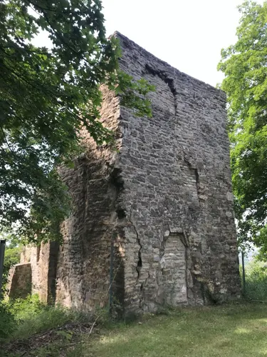


Flamme der Freundschaft
Monument and historic site
Denkmal zum erstmaligen Einsatz von sowjetischem Erdgas in der Hettstedter Industrie


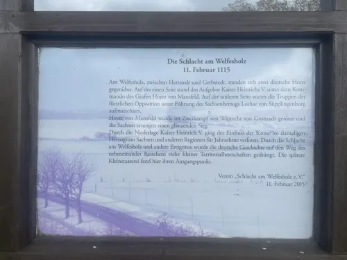

Maschinendenkmal
Monument and historic site · 2.1 km
Standort der ersten Deutschen Dampfmaschine Watt'scher Bauart
9 more on the map.
Parks, trails and playgrounds10




Restaurants and cafes22






10 more on the map.
History
As of 1911, Hettstedt engaged in the manufacture of machinery, pianofortes, and artificial manure, and the surrounding district and villages were occupied with smelting due to the nearby mines of argentiferous copper. Other products included silver, sulphuric acid, and small quantities of nickel and gold.
In the Kaiser Friedrich mine close by, the first steam engine in Germany was erected on 23 August 1785. Hettstedt is mentioned as early as 1046; in 1220 it possessed a castle; in 1380 it received civic privileges. When the county of Mansfeld was sequestrated, Hettstedt came into the possession of Saxony, passing to Prussia in 1815.
From the History section of Hettstedt on Wikipedia, under CC BY-SA 4.0.
Where to stay3
Churches and places of worship13
Shopping16
Fahrradshop und Schlüsseldienst Quaranta
Shop · 1.1 km
19a Molmecker Straße, Hettstedt
Gas and EV charging4
Schools, colleges and libraries9
Kreisvolkshochule Mansfeld-Suedharz e.V. Geschaeftsstelle Hettstedt
School · 0.7 km
1 Pestalozzistraße, Hettstedt
Healthcare3
Map of Hettstedt
106 places. The map loads OpenStreetMap tiles when you open it.
Getting there and nearby towns
Magdeburg-Cochstedt Airport (CSO) is the nearest airport with scheduled flights listed in OpenStreetMap, 24 km away.
- Staßfurt 23 km north, about 23 min by car
- Sangerhausen 25 km southwest, about 25 min by car
- Quedlinburg 29 km northwest, about 29 min by car
- Köthen 34 km east, about 34 min by car
- Thale 34 km west, about 34 min by car
- Halle (Saale) 37 km southeast, about 37 min by car
- Schönebeck 43 km north, about 43 min by car
- Merseburg 47 km southeast, about 47 min by car
- Wolfen 52 km east, about 52 min by car
- Magdeburg 54 km north, about 54 min by car
Drive times are estimates from straight-line distance, not routes.
Local news
Headlines from INDB.
Reviews, tips and questions
Loading what members have shared...
Sources and licences
- GeoNames (CC BY 4.0): population, coordinates, regions and time zone
- Mapillary (see each image): photos
- OpenStreetMap contributors (ODbL 1.0): places, airports, map data
- Wikidata (CC0 1.0): elevation, founding date, time zone, website
- Wikimedia Commons (see each image): photos
- Wikipedia (CC BY-SA 4.0): overview and history text
Photo credits
- Hettstedt, Joeb07, CC BY 3.0
- Hettstedt, die Straße "Sperlingsberg", Dguendel, CC BY 3.0
- Hettstedt, am Sperlingsberg, Dguendel, CC BY 3.0
- Ortsansicht-Hettstedt, Dguendel, CC BY-SA 3.0
- Hettstedt, Freimarkt und Saigertor, Dguendel, CC BY 4.0
- 2020-11 Hettstedt (09) WGH, Ralf Lotys (Sicherlich), CC BY 4.0
- Hettstedt, Haus Maxgasse 2, Dguendel, CC BY 4.0
- 2020-11 Hettstedt (08) WGH, Ralf Lotys (Sicherlich), CC BY 4.0
- Hettstedt, Haus Freimarkt 13, Dguendel, CC BY 4.0
- Hettstedt, a row of houses on the Freimarkt, Dguendel, CC BY 3.0
- Hettstedt, the town square, Dguendel, CC BY 3.0
- Hettstedt, the town square "Freimarkt", Dguendel, CC BY 3.0
- Hettstedt, the Saigertor, Dguendel, CC BY 3.0
- Brunnen auf dem Markt in Hettstedt 2, Gerd Fahrenhorst, CC BY 4.0
- Brunnen auf dem Markt in Hettstedt 1, Gerd Fahrenhorst, CC BY 4.0
- Brunnen auf dem Markt in Hettstedt 3, Gerd Fahrenhorst, CC BY 4.0
- Hettstedt Saigertor, Joeb07, CC BY 3.0
- 2020-11 Hettstedt (03) Flamme der Freundschaft, Ralf Lotys (Sicherlich), CC BY 4.0
- 2020-11 Hettstedt (04) Flamme der Freundschaft, Ralf Lotys (Sicherlich), CC BY 4.0
- 2020-11 Hettstedt (06) Flamme der Freundschaft, Ralf Lotys (Sicherlich), CC BY 4.0
- 2020-11 Hettstedt (07) Flamme der Freundschaft, Ralf Lotys (Sicherlich), CC BY 4.0
- Markt mit Saigertor, Hettstedt, Gerd Fahrenhorst, CC BY 4.0
- Hettstedt, das Saigertor, Dguendel, CC BY 4.0
- Hettstedt Freimarkt, Joeb07, CC BY 3.0
- Hettstedt, die Novalisstraße, Dguendel, CC BY 3.0
- Hettstedt, Haus Markt 31, Dguendel, CC BY 4.0
- 2020-11 Hettstedt (02) Flamme der Freundschaft, Ralf Lotys (Sicherlich), CC BY 4.0
- 2020-11 Hettstedt (01) Flamme der Freundschaft, Ralf Lotys (Sicherlich), CC BY 4.0
- Hettstedt, die Hadebornstraße, Dguendel, CC BY 3.0
- Hettstedt, die ehemalige Löwenapotheke,jpg, Dguendel, CC BY 3.0
- Hettstedt, die Wipper, Dguendel, CC BY 3.0
- Hettstedt Zuckerhut, Joeb07, CC BY 3.0
- Hettstedt-St-Jacobi, Dguendel, CC BY-SA 3.0
- Hettstedt, Haus Markt 35, Dguendel, CC BY 3.0
- Hettstedt, Hinter den Planken, Dguendel, CC BY 4.0
- Hettstedt Markt, Joeb07, CC BY 3.0
- Hettstedt, der Zuckerhut, Dguendel, CC BY 4.0
- Hettstedt, Haus Markt 35, Bild 2, Dguendel, CC BY 4.0
- Panorama Blick auf Siersleben von Welfesholz, Pomfuttge, CC BY 3.0
- Schloss Oberwiederstedt, Benutzer:Hejkal, CC BY-SA 3.0 de
- Walbeck (Hettstedt), das Schloss, Dguendel, CC BY-SA 4.0
- Hettstedt Katholische Kirche, Joeb07, CC BY 3.0
- OberwiederstedtKirche2, Jwaller, CC BY-SA 3.0
- Hettstedt Kirche, Joeb07, CC BY 3.0
- Dorfkirche Arnstedt, Pomfuttge, CC BY-SA 3.0
- WelfesholzKapelle1, Jwaller, CC BY-SA 3.0
- Walbeck (Hettstedt), Andreaskirche, der Turm, Dguendel, CC BY-SA 4.0
- Hettstedt Heilandskirche 01, ErwinMeier, CC BY-SA 4.0
- 2. Steinkreuz Welfesholz, Pomfuttge, CC BY-SA 3.0
- 2020-11 Schießberg (06) Kalksteinbruch, Ralf Lotys (Sicherlich), CC BY 4.0
- Verwovener Stein bei Welfesholz 1, Pomfuttge, CC BY-SA 4.0
- 2020-11 Hettstedt (05) Flamme der Freundschaft, Ralf Lotys (Sicherlich), CC BY 4.0
- Burgörner (Hettstedt), Mansfeld-Museum, Treppenhaus, Dguendel, CC BY 3.0
- Hettstedt-Gangolfkirche, Dguendel, CC BY-SA 3.0
- Hettstedt, das Maschinendenkmal-3, Dguendel, CC BY 3.0
- Street-level photo, AR88, CC BY-SA 4.0
- Street-level photo, surveyor99, CC BY-SA 4.0
- Street-level photo, AR88, CC BY-SA 4.0
- Street-level photo, AR88, CC BY-SA 4.0
- Street-level photo, AR88, CC BY-SA 4.0
- Street-level photo, AR88, CC BY-SA 4.0
- Street-level photo, AR88, CC BY-SA 4.0
- Street-level photo, AR88, CC BY-SA 4.0
- Street-level photo, AR88, CC BY-SA 4.0
- Street-level photo, surveyor99, CC BY-SA 4.0
- Street-level photo, AR88, CC BY-SA 4.0
- Street-level photo, surveyor99, CC BY-SA 4.0
- Street-level photo, AR88, CC BY-SA 4.0
- Street-level photo, AR88, CC BY-SA 4.0
- Street-level photo, AR88, CC BY-SA 4.0


Page built November 8, 2026. Spotted a mistake? Tell us or suggest a place.