
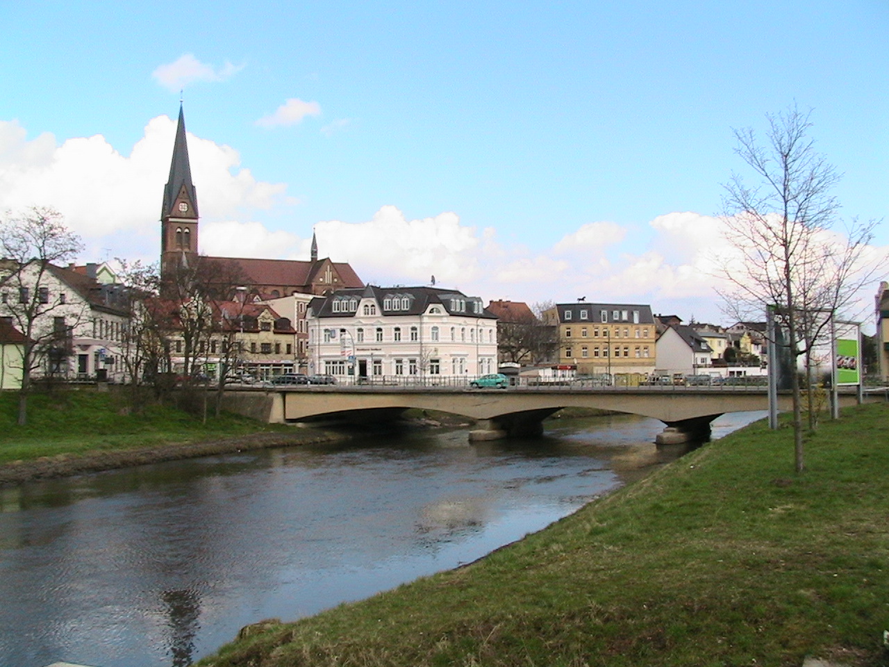


Why visit Staßfurt
Townapedia lists 62 museums and landmarks, 11 parks and trails, 43 places to eat, 14 places to stay and 13 attractions in and around town.
Highlights include Tiergarten Staßfurt, Salzlandtheater, Eisenbahnfreunde Traditionsbahnbetriebswerk Staßfurt e.V. and Blaue Gans.
Weather in Staßfurt
Forecast from MET Norway (CC BY 4.0). Full forecast
About Staßfurt
Staßfurt (Stassfurt) (German pronunciation: [ˈʃtasfʊʁt] ) is a town in the Salzlandkreis district, in Saxony-Anhalt, Germany. It is situated on both sides of the river Bode, approximately 15 km (9.3 mi) northeast of Aschersleben and 30 km (19 mi) south of Magdeburg. Pop. (2005) 23,538.
From the Wikipedia article Staßfurt (this version), under CC BY-SA 4.0.
Things to do13



Landwirtschaftsbetrieb Hauser
Farm and orchard · 7.7 km
12 Hauptstraße, Staßfurt
Tu-Fr 10:00-18:00; Sa 09:00-15:00; Mo,Su,PH off

1 more on the map.
Museums and landmarks62

Eisenbahnfreunde Traditionsbahnbetriebswerk Staßfurt e.V.
Museum · 1.7 km
13 Güstener Weg, Staßfurt
"Nur zu bestimmten Ereignissen oder auf Anfrage siehe...

Blaue Gans
Monument and historic site · 8.6 km
Menhir Blaue Gans, zwischen Windrädern in einer Anpflanzung von Bäumen, nördlich von Achersleben

Wasserturm Löderburg
Monument and historic site · 3.5 km
Wasserturm, Staßfurter Straße südöstliches des Ortes in der Neubausiedlung, in Staßfurt OT Löderburg
Staßfurter Straße, Staßfurt

Anhaltischer Meilenstein
Monument and historic site · 9.7 km
Anhaltischer Meilenstein (0682) an der L 72 südlich von Warmsdorf in Giersleben

Fahrzeugmuseum Staßfurt
Museum · 1.4 km
14 Berlepschstraße, Staßfurt
Fr-Su 11:00-18:00; "on appointment"

Gudenesstein
Monument and historic site · 6.3 km
Gudenesstein (Menhir, auch Speckseite oder Guddenstein genannt), Bernburger Straße in Güsten
Rundfunk- und Fernsehgerätesammlung Staßfurt
Museum · 1.6 km
73 Löderburger Straße, Staßfurt
Mo-Th 08:00-14:00; Fr 08:00-12:00; Sa[1] 09:30-12:30


Schloss Neugattersleben
Monument and historic site · 8.2 km
1 Friedensstraße, Nienburg (Saale)


Wasserturm
Monument and historic site · 6.8 km
Wasserturm am Personenbahnhof, Bahnhofstraße in Güsten

50 more on the map.
Parks, trails and playgrounds11



Restaurants and cafes43

Bäckerei Stelmecke
Bakery · 7.6 km
2 Dorfstraße, Staßfurt
Mo-Fr 06:00-12:00,14:00-17:00; Sa 06:00-11:00; Su,PH off
Bäckerei Winkel
Bakery · 3.7 km
29 Alte Güstener Straße, Staßfurt
Mo-Fr 06:00-17:00; Sa 06:00-10:30; Su,PH off



Asteria
Restaurant · Greek · 3.7 km
5 Alte Güstener Straße, Staßfurt
Tu-Sa 11:30-14:30,17:00-23:00; Su,PH 11:30-23:00
Goldener Tempel
Restaurant · Asian · 2.0 km
99 Löderburger Straße, Staßfurt
Tu-Su 11:00-15:00,17:30-23:00

Halberstädter Bäcker & Konditoren
Bakery · 6.5 km
Mo-Fr 08:00-19:00; Sa 08:00-17:00; PH closed
31 more on the map.
History
The first mention of the place was in connection with the village of Alt-Staßfurt in 806, in an invitation by Emperor Charlemagne to the Abbot Fulrad of St. Quentin to hold an army meeting at Starasfurt on the Bode River. The interpretation of the name is most likely from a composition of the Old Slavic word for old (staraja) with the Old High German word for river-crossing (furt).
The importance of Staßfurt in the Middle Ages was due to its location. Here, the old trading and salt road led from Lüneburg coming to Halle. The village Alt-Staßfurt north of the Bode was temporally and spiritually under the Archbishop of Magdeburg. In the 11th century, a castle was built south of the Bode. By 1180, the city law was extended to settlement areas south of the Bode within the defensive walls. Until 1277, Staßfurt and its castle was in the possession of the Anhalt Counts. Afterward, the brother Dukes of Saxony, John I and Albrecht II, held such a huge banquet celebrating their knighthoods that they to settle the debt of 6,000 silver marks by pledging Staßfurt to Archbishop Conrad II of Magdeburg on 8 July 1276.
From the History section of Staßfurt on Wikipedia, under CC BY-SA 4.0.
Where to stay14
Stadtschloß Hecklingen
Motel and hotel · 3.5 km
4 Hugo-Gast-Siedlung, Hecklingen
Pension Renate Korth Karlstraße 19 39446 Staßfurt (Löderburg)
Motel and hotel · 4.2 km
Churches and places of worship23
Shopping20
Gas and EV charging11
Schools, colleges and libraries14
Hochschule Anhalt
School · 9.1 km
28 Strenzfelder Allee, Bernburg (Saale)
Healthcare7
Map of Staßfurt
218 places. The map loads OpenStreetMap tiles when you open it.
Getting there and nearby towns
Magdeburg-Cochstedt Airport (CSO) is the nearest airport with scheduled flights listed in OpenStreetMap, 12 km away.
- Magdeburg 31 km north, about 31 min by car
- Zerbst 37 km east, about 37 min by car
- Wolmirstedt 44 km north, about 44 min by car
- Halle (Saale) 49 km southeast, about 49 min by car
- Wolfen 52 km southeast, about 52 min by car
- Schöningen 53 km northwest, about 53 min by car
- Wernigerode 55 km west, about 55 min by car
- Helmstedt 57 km northwest, about 57 min by car
- Königslutter am Elm 69 km northwest, about 1 h 15 min by car
- Leipzig 79 km southeast, about 1 h 15 min by car
Drive times are estimates from straight-line distance, not routes.
Local news
Headlines from INDB.
Reviews, tips and questions
Loading what members have shared...
Sources and licences
- GeoNames (CC BY 4.0): population, coordinates, regions and time zone
- Mapillary (see each image): photos
- OpenStreetMap contributors (ODbL 1.0): places, airports, map data
- Wikidata (CC0 1.0): elevation, founding date, time zone, website, landmarks and historic places
- Wikimedia Commons (see each image): photos
- Wikipedia (CC BY-SA 4.0): overview and history text
Photo credits
- Stassfurt Bodebruecke, The original uploader was Wossi1991 at German Wikipedia ., CC BY-SA 3.0
- Staßfurt, das Salzland-Theater, Dguendel, CC BY 3.0
- Staßfurt, die Häuser Steinstraße 20-22, Dguendel, CC BY-SA 4.0
- Staßfurt, die Schmiedestraße, Dguendel, CC BY 3.0
- Staßfurt, the Steinstraße, Dguendel, CC BY 3.0
- Staßfurt, Wohn- und Geschäftshaus Steinstraße 19, Dguendel, CC BY-SA 4.0
- Staßfurt, Haus Steinstraße 47, Dguendel, CC BY 3.0
- Staßfurt, the houses 19 and 20 Steinstraße, Dguendel, CC BY 3.0
- Staßfurt, die Häuser Steinstraße 19 und 20, Dguendel, CC BY-SA 4.0
- Staßfurt, die Alte Zwingerstraße, Dguendel, CC BY 3.0
- Staßfurt, Freigelände des Bergbaumuseums, Dguendel, CC BY 3.0
- Staßfurt Stolperstein Charlotte Schlums, Migebert, CC BY-SA 4.0
- Staßfurt Stolperstein Helene Rosenberg, Migebert, CC BY-SA 4.0
- Staßfurt Stolperstein Gustav Rosenberg, Migebert, CC BY-SA 4.0
- Staßfurt Stolpersteine Rosenberg Schlums, Migebert, CC BY-SA 4.0
- Staßfurt, die Steinstraße, Dguendel, CC BY 3.0
- Staßfurt, the Schmiedestraße, Dguendel, CC BY 3.0
- Staßfurt, Haus Steinstraße 39, Dguendel, CC BY 3.0
- Staßfurt, Verwaltungsgebäude Wobau und Stadtwerke, Dguendel, CC BY 3.0
- Staßfurt Stolperstein David Bartfeld, Migebert, CC BY-SA 4.0
- Gefasste Flamme (Staßfurt) 3, Gerd Fahrenhorst, CC BY 4.0
- Gefasste Flamme (Staßfurt) 1, Gerd Fahrenhorst, CC BY 4.0
- Gefasste Flamme (Staßfurt) 2, Gerd Fahrenhorst, CC BY 4.0
- Staßfurt Stolperstein Elli Leontine Schönstädt, Migebert, CC BY-SA 4.0
- Staßfurt Stolperstein Julius Schönstädt, Migebert, CC BY-SA 4.0
- Staßfurt Stolpersteine Steinstraße 39 (ehemals 22), Migebert, CC BY-SA 4.0
- Salzblüte (Staßfurt) 3, Gerd Fahrenhorst, CC BY 4.0
- Salzblüte (Staßfurt) 2, Gerd Fahrenhorst, CC BY 4.0
- Salzblüte (Staßfurt) 1, Gerd Fahrenhorst, CC BY 4.0
- Staßfurt, das Nettelbecksche Haus, Dguendel, CC BY-SA 4.0
- Stadtsee in Staßfurt, Gerd Fahrenhorst, CC BY 4.0
- 2005-05-05 - Hauptgebäude FH Anhalt-Köthen, Ralf Lotys (Sicherlich), CC BY 2.5
- St Severin Ilberstedt, Olaf Meister ( Olaf2 ), CC BY-SA 4.0
- J40 839St. Georg und Pancratius, Apsis, Falk2, CC BY-SA 4.0
- NeugattSchloss, Greifen, CC BY-SA 3.0
- Sankt Clemens Kirche Groß Börnecke, Olaf Meister, CC BY-SA 3.0
- Blaue Gans Vorderseite 04, Migebert, CC BY-SA 3.0
- Schloss Hohenerxleben, Meleagros, CC BY-SA 3.0 de
- Ilberstedt Anhaltischer Meilenstein, Radler59, CC BY-SA 3.0
- Hecklingen, Hugo-Gast-Siedlung, Schloss 20170713 001, Tilman2007, CC BY-SA 4.0
- KircheLoederburg4, Ghostwriter123, CC BY-SA 4.0
- Atzendorf(Staßfurt)Kirche, Greifen, CC BY-SA 3.0
- Glöthe (Staßfurt), the village church, Dguendel, CC BY 3.0
- Üllnitz (Staßfurt), the village church, Dguendel, CC BY 3.0
- Stadtpalais Werdensleben, Olaf Meister ( Olaf2 ), CC BY-SA 4.0
- Gnadenkirche Giersleben Südseite, W.ewert, CC BY-SA 4.0
- Staßfurt Marien 2021-1, Kirchenfan, CC0
- Loederburg Wasserturm-01-2, Radler59 ( talk ), CC BY-SA 4.0
- Giersleben Anhaltinischer Meilenstein-01, Radler59 ( talk ), CC BY-SA 4.0
- Guesten Wasserturm Bf-01, Radler59 ( talk ), CC BY-SA 4.0
- Amesdorf Kirche, Radler59 ( talk ), CC BY-SA 4.0
- Rathmannsdorf St.-Pauli-Kirche, Radler59 ( talk ), CC BY-SA 4.0
- Güsten,St.Vitus-Kirche, M_H.DE, CC BY 3.0
- 41stassfurt, HeizDampf at German Wikipedia ( Original text: Uwe B. Pfotenhauer ), CC BY-SA 3.0
- Staßfurt Zoo Eingang Außenansicht, Olaf Meister, CC BY-SA 3.0
- Güsten,Gudenesstein, M_H.DE, CC BY 3.0
- Foerderstedt Steinkreuz, Radler59, CC BY-SA 3.0
- Street-level photo, bejotel, CC BY-SA 4.0
- Street-level photo, surveyor99, CC BY-SA 4.0
- Street-level photo, AR88, CC BY-SA 4.0
- Street-level photo, britiger, CC BY-SA 4.0
- Street-level photo, britiger, CC BY-SA 4.0
- Street-level photo, bejotel, CC BY-SA 4.0
- Street-level photo, moenk, CC BY-SA 4.0


Page built November 8, 2026. Spotted a mistake? Tell us or suggest a place.