


Dumfries, Virginia
Dumfries is a town of 5,816 people in Prince William County, Virginia, founded in 1749.
Why visit Dumfries
Townapedia lists 10 museums and landmarks, 7 parks and trails, 44 places to eat and 8 places to stay in and around town.
Highlights include Weems–Botts Museum, Cabin Branch Pyrite Mine Historic District, C. Lacey Compton Neighborhood Park and Cecil W Garrison Park.
July is the warmest month, with average highs of 88°F; January lows average 28°F.
Weather in Dumfries
Forecast from the National Weather Service. Full forecast
About Dumfries
Dumfries, officially the Town of Dumfries, is a town in Prince William County, Virginia, United States. As of the 2020 census, Dumfries had a population of 5,679.
From the Wikipedia article Dumfries, Virginia (this version), under CC BY-SA 4.0.
Museums and landmarks10

Weems–Botts Museum
Museum · National Register of Historic Places · 0.8 mi
Building in Virginia, United States

Cabin Branch Pyrite Mine Historic District
Monument and historic site · National Register of Historic Places · 2.0 mi
Historic district in Virginia, United States
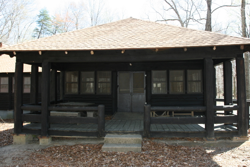
Chopawamsic Recreational Demonstration Area Cabin Camp 1
Monument and historic site · National Register of Historic Places · 3.0 mi
Civilian Conservation Corps campsite

Commanding General's Quarters, Quantico Marine Base
Monument and historic site · National Register of Historic Places · 2.7 mi
Historic house in Virginia, United States

Old Hotel
Monument and historic site · National Register of Historic Places · 0.5 mi
Hotel in Dumfries, Virginia

Orenda/SP-26 Historic District, Chopawamsic RDA Camp 3
Monument and historic site · National Register of Historic Places · 2.4 mi
Recreational demonstration camp

Pleasant Historic District, Chopawamsic RDA Camp 4
Monument and historic site · National Register of Historic Places · 2.7 mi
Historic district in Virginia, United States

Old Town Hall and School
Monument and historic site · National Register of Historic Places · 0.5 mi



National Museum of the Marine Corps
Museum · 2.1 mi
Official museum of the United States Marine Corps, in Triangle, Virginia
Parks, trails and playgrounds7

C. Lacey Compton Neighborhood Park
Park · 1.2 mi
17301 River Ridge Boulevard, Woodbridge
Restaurants and cafes44

Baskin-Robbins
Ice cream · Ice Cream · 0.9 mi
18021 Main Street, Dumfries
Mo-Fr 04:30-22:00; Sa-Su 05:30-22:00


1609 Prime Cuts + Cocktails
Restaurant · Steak House · 0.8 mi
17680 Colonial Street, Dumfries
California Tortilla
Restaurant · Mexican · 1.4 mi
3934 Fettler Park Drive, Dumfries
El Paso Mexican Grill
Restaurant · Mexican · 1.5 mi
16918 Dumfries Road, Dumfries
Montclair Family Restaurant
Diner · American · 1.4 mi
17001 Dumfries Road, Dumfries
32 more on the map.
Where to stay8

Candlewood Suites Dumfries - Quantico
Motel and hotel · 1.4 mi
16927 Old Stage Road, Dumfries
History
The history of Dumfries began as early as 1690 when Richard Gibson erected a gristmill on Quantico Creek. A customhouse and warehouse followed in 1731, and many others cropped up along the estuary by 1732. The Town of Dumfries was formally established on 60 acres (240,000 m2) of land at the head of the harbor of Quantico Creek, provided by John Graham. He named the town after his birthplace, Dumfries, Scotland.
After much political maneuvering, the General Assembly established Dumfries as the first of seven townships in the county. Dumfries received its charter on May 11, 1749, making it the oldest continuously chartered town in Virginia.
The Ceremonial Seal of the Town of Dumfries embodies elements of its heritage, from the period of 1651, when the first patents were issued to colonists, who following the Potomac recognized the value of a snug harbor in Quantico Creek. Thus the foundations for the establishment of a town, which in 1749 received its charter from the Colonial government in Williamsburg, Virginia.
The elements of the seal are contained within the pattern formed by the outer frame of a hawser rope or cable, and the inner frame of an anchor chain, of a type employed in ships of the Colonial era.
From the History section of Dumfries, Virginia on Wikipedia, under CC BY-SA 4.0.
Churches and places of worship15
Iglesia Cristiana Cristo Es Tu Libertador
Church · 0.8 mi
17832 Main Street, Dumfries
The Church of Pentecost Shiloh Assembly
Church · 0.8 mi
17311 Richmond Highway, Dumfries
Shopping5
Gas and EV charging11
Schools, colleges and libraries33
Fannie W. Fitzgerald Elementary
School · 3.6 mi
15500 Benita Fitzgerald Drive, Woodbridge
Healthcare4
Greater Prince William Community Health Center
Clinic and pharmacy · 0.6 mi
17739 Main Street, Dumfries
Map of Dumfries
137 places. The map loads OpenStreetMap tiles when you open it.
Climate by month
Monthly table
| Month | High | Low | Rain | Snow |
|---|---|---|---|---|
| Jan | 45°F | 28°F | 2.7 in | 3.5 in |
| Feb | 48°F | 30°F | 2.4 in | 5.8 in |
| Mar | 56°F | 37°F | 3.6 in | 1.4 in |
| Apr | 68°F | 47°F | 3.2 in | 0.0 in |
| May | 76°F | 57°F | 3.6 in | 0.0 in |
| Jun | 84°F | 66°F | 3.5 in | 0.0 in |
| Jul | 88°F | 71°F | 4.6 in | 0.0 in |
| Aug | 86°F | 69°F | 4.2 in | 0.0 in |
| Sep | 80°F | 62°F | 3.4 in | 0.0 in |
| Oct | 69°F | 50°F | 3.3 in | 0.0 in |
| Nov | 58°F | 39°F | 3.1 in | 0.0 in |
| Dec | 49°F | 32°F | 3.3 in | 1.7 in |
U.S. Climate Normals 1991-2020 for Quantico Mcas (5 mi away), NOAA NCEI.
People and cost of living
American Community Survey 5-year estimates, 2020-2024, U.S. Census Bureau. Estimates have margins of error, larger for small towns.
Disaster history
Prince William County has had 14 federal disaster declarations since 2000, most often for hurricanes.
- 2026-01-23: Severe Winter Storm (Winter Storm)
- 2020-04-02: Covid-19 Pandemic (Biological)
- 2020-03-13: Covid-19 (Biological)
- 2018-09-11: Hurricane Florence (Hurricane)
- 2016-03-07: Severe Winter Storm And Snowstorm (Snowstorm)
- 2012-11-26: Hurricane Sandy (Hurricane)
OpenFEMA disaster declarations summaries.
Getting there and nearby towns
Quantico Marine Corps Airfield/Turner Field (NYG) is the nearest airport with scheduled flights listed in OpenStreetMap, 4 miles away.
- Triangle 1 mi south, about 2 min by car
- Cherry Hill 2 mi east, about 3 min by car
- Leesylvania 3 mi northeast, about 6 min by car
- Montclair 4 mi northwest, about 6 min by car
- Dale City 6 mi north, about 10 min by car
- Woodbridge 6 mi northeast, about 10 min by car
- Lake Ridge 8 mi north, about 13 min by car
- Independent Hill 8 mi northwest, about 13 min by car
- Aquia Harbour 8 mi southwest, about 13 min by car
- Indian Head 9 mi east, about 14 min by car
Drive times are estimates from straight-line distance, not routes.
Local news
Headlines from INDB, the NEMICO news database.
Reviews, tips and questions
Loading what members have shared...
Sources and licences
- NCES EDGE (Public domain): public schools
- NOAA NCEI U.S. Climate Normals 1991-2020 (Public domain): climate by month
- OpenFEMA (Public domain): disaster declarations
- OpenStreetMap contributors (ODbL 1.0): places, airports, map data
- U.S. Census Bureau (Public domain): population, income, housing, education, commute
- Wikidata (CC0 1.0): elevation, founding date, time zone, website, landmarks and historic places
- Wikimedia Commons (see each image): photos
- Wikipedia (CC BY-SA 4.0): overview and history text
Photo credits
- Henderson House (Dumfries, Virginia) 003, Leonard J. DeFrancisci, CC BY-SA 3.0
- 2018-10-10 10 12 38 View south along U.S. Route 1 (Main Street) at Possum Point Road in Dumfries, Prince William County, Virginia, Famartin, CC BY-SA 4.0
- Quantico Dam - Dumfries, VA (15954586619), U. S. Fish and Wildlife Service - Northeast Region, Public domain
- 2018-10-10 10 23 35 View north along U.S. Route 1 (Jefferson Davis Highway) just south of Virginia State Route 234 (Dumfries Road) in Dumfries, Prince William County, Virginia, Famartin, CC BY-SA 4.0
- 2019-10-17 08 56 22 View north along Virginia State Route 234 (Dumfries Road) at the exit for Interstate 95 NORTH (Washington) in Cherry Hill, Prince William County, Virginia, Famartin, CC BY-SA 4.0
- 2019-05-29 13 58 17 View north along Interstate 95 at Exit 152A (Virginia State Route 234 SOUTH, Dumfries) just east of Dumfries in Prince William County, Virginia, Famartin, CC BY-SA 4.0
- 2019-05-29 14 00 09 View north along Interstate 95 at Exit 152B (Virginia State Route 234 NORTH, Manassas) just north of Dumfries in Prince William County, Virginia, Famartin, CC BY-SA 4.0
- 2019-06-24 13 15 01 View south along Interstate 95 from the overpass for Virginia State Route 234 (Dumfries Road) just north of Dumfries in Prince William County, Virginia, Famartin, CC BY-SA 4.0
- 2019-06-24 13 21 46 View north along Interstate 95 from the overpass for Virginia State Route 234 (Dumfries Road) on the edge of Cherry Hill and Montclair in Prince William County, Virginia, Famartin, CC BY-SA 4.0
- 2019-10-17 09 11 32 View north along Virginia State Route 234 (Dumfries Road) at the exit for Interstate 95 SOUTH (Richmond) in Montclair, Prince William County, Virginia, Famartin, CC BY-SA 4.0
- 2019-10-18 13 13 17 View south along Virginia State Route 234 (Dumfries Road) at the exit for Interstate 95 NORTH (Washington) in Montclair, Prince William County, Virginia, Famartin, CC BY-SA 4.0
- 2019-05-29 11 58 16 View south along Interstate 95 at Exit 152A (Virginia State Route 234 SOUTH, Dumfries) on the edge of Montclair and Cherry Hill in Prince William County, Virginia, Famartin, CC BY-SA 4.0
- 2019-10-18 13 10 41 View south along Virginia State Route 234 (Dumfries Road) at the exit for Interstate 95 SOUTH (Richmond) in Montclair, Prince William County, Virginia, Famartin, CC BY-SA 4.0
- I-95 NB Dumfries VA HOT toll gantry, Dough4872, CC BY-SA 3.0
- Weems-Botts House (Dumfries, Virginia) 001, Leonard J. DeFrancisci, CC BY-SA 3.0
- Chopawamsic Camp 4 dining VA NPS, National Park Service, Public domain
- Chopawamsic Camp 1 VA NPS, National Park Service, Public domain
- AACA concentrate bin ruins VA NPS, National Park Service, Public domain
- OLD HOTEL; PRINCE WILLIAM COUNTY, Jerrye & Roy Klotz, MD, CC BY-SA 3.0
- Commander's House, LeiferJM, CC BY-SA 3.0
- OLD TOWN HALL AND SCHOOL, PRINCE WILLIAM COUNTY, VA, Jerrye & Roy Klotz, MD, CC BY-SA 3.0
- Museum of the marines corps, RadioFan ( talk ), CC BY-SA 3.0
- Builder grade white picket count (30232755626), The Finishing Company Richmond Va from Richmond,Virginia, United States, CC BY 2.0
- Prince William iron baluster remodel (30232756856), The Finishing Company Richmond Va from Richmond,Virginia, United States, CC BY 2.0
- Historical horse racing machines at The Rose, Toohool, CC BY-SA 4.0
- Virginia-Va-state-stair-baluster-install (30267627595), The Finishing Company Richmond Va from Richmond,Virginia, United States, CC BY 2.0
- Venetian balusters easing (30232755706), The Finishing Company Richmond Va from Richmond,Virginia, United States, CC BY 2.0
- Trees in Prince William Park Forest 4, Kurt Kaiser, CC0
- Trees in Prince William Park Forest 3, Kurt Kaiser, CC0
- Small yellow green turtle, Kurt Kaiser, CC0
- Small turtle in National Park outside of DC, Kurt Kaiser, CC0
- Small turtle, Kurt Kaiser, CC0
- 2019-05-29 11 55 05 View south along Interstate 95 at Exit 152B (Virginia State Route 234 NORTH, Manassas) on the edge of Montclair and Cherry Hill in Prince William County, Virginia, Famartin, CC BY-SA 4.0


Page built October 30, 2026. Spotted a mistake? Tell us or suggest a place.