


Forest Hills, Pennsylvania
Forest Hills is a borough of 6,286 people in Allegheny County, Pennsylvania, founded in July 29, 1919.
Why visit Forest Hills
Townapedia lists 25 museums and landmarks, 15 parks and trails, 13 places to eat and 7 attractions in and around town.
Highlights include Carrie Furnace Hot Metal Bridge, Fern Hollow Bridge, Baxter High School and Bost Building.
July is the warmest month, with average highs of 84°F; January lows average 22°F.
Weather in Forest Hills
Forecast from the National Weather Service. Full forecast
About Forest Hills
Forest Hills is a borough in Allegheny County, Pennsylvania, United States. The population was 6,429 at the 2020 census. It is a suburb of the Pittsburgh metropolitan area. The borough was named after Forest Hills, Queens.
From the Wikipedia article Forest Hills, Pennsylvania (this version), under CC BY-SA 4.0.
Things to do7

Carrie Furnace Hot Metal Bridge
Bridge · 2.0 mi
Bridge over the Monongahela River

Fern Hollow Bridge
Bridge · 2.6 mi
Bridge in Pittsburgh, Pennsylvania, US built in 2022

Forest Hills Farmers Market
Farm and orchard · 0.9 mi
4400 Greensburg Pike, Pittsburgh
May Fr[3]-Oct Fr[-1] +1 day Fr 16:00-19:00

Pinkerton's Landing Bridge
Bridge · 2.3 mi
Train bridge over Monongahela River

PRR Port Perry Bridge
Bridge · 2.6 mi
Railroad bridge in Pennsylvania

Rankin Bridge
Bridge · 1.9 mi
Bridge in Allegheny County, Pennsylvania
Union Railroad Port Perry Bridge
Bridge · 2.6 mi
Bridge in Pennsylvania, United States of America
Museums and landmarks25

Baxter High School
Monument and historic site · National Register of Historic Places · 2.8 mi
High school in Pennsylvania, United States

Bost Building
Monument and historic site · National Register of Historic Places · 2.9 mi
Building in Pennsylvania, United States
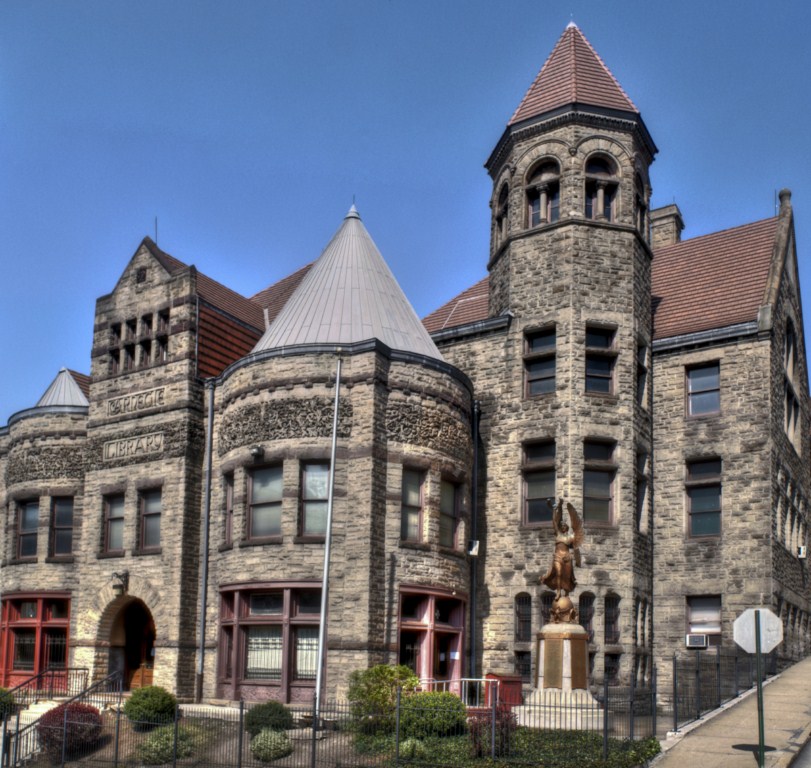
Carnegie Free Library of Braddock
Monument and historic site · National Register of Historic Places · 1.7 mi
Carnegie library in Pennsylvania

Gardner-Bailey House
Monument and historic site · National Register of Historic Places · 1.8 mi
Historic house in Pennsylvania, United States
George Westinghouse Bridge
Bridge · National Register of Historic Places · 2.5 mi
Concrete arch bridge over Turtle Creek
Hamnett Historic District
Monument and historic site · National Register of Historic Places · 1.8 mi
Historic district in Pennsylvania, United States
Homestead Historic District
Monument and historic site · National Register of Historic Places · 3.1 mi
Historic district in Pennsylvania, United States
Homestead station
Monument and historic site · National Register of Historic Places · 3.3 mi
Former train station in Homestead, Pennsylvania

John F. Singer House
Monument and historic site · National Register of Historic Places · 2.1 mi
Listed on the National Register of Historic Places in Wilkinsburg, Pennsylvania

Kennywood
Monument and historic site · National Register of Historic Places · 2.6 mi
Amusement park in Pennsylvania

Longfellow School
Monument and historic site · National Register of Historic Places · 2.0 mi
School in Swissvale, Pennsylvania

Old Heidelberg Apartments
Monument and historic site · National Register of Historic Places · 2.5 mi
Building in Pennsylvania, United States
13 more on the map.
Parks, trails and playgrounds15




Westinghouse Park
Park · 3.2 mi
Park in Pennsylvania, United States of America, United States of America
Forest Hills Westinghouse Recreation Center
Park · 0.8 mi
799 Barclay Avenue, Pittsburgh

3 more on the map.
Restaurants and cafes13


Vincent's Pizza Park
Restaurant · Pizza · 1.1 mi
998 Ardmore Boulevard, Forest Hills
We-Th 16:00-22:00; Fr-Sa 16:00-23:00; Su 16:00-22:00
Zhen Choo Chinese Resturaunt
Restaurant · Asian · 0.8 mi
268 Yost Boulevard, Pittsburgh
The Pike Bar & Grill
Bar and pub · 1.1 mi
944 Greensburg Pike, Forest Hills


1 more on the map.
Churches and places of worship14
Beulah Presbyterian Church
Church · National Register of Historic Places · 1.5 mi
Bridge City Church-North Braddock
Church · Nondenominational · 1.4 mi
1200 Wolfe Avenue, North Braddock
St. John Fisher Church
Church · Roman Catholic · 0.9 mi
33 Lewin Lane, Pittsburgh
Shopping2
Gas and EV charging3
Schools, colleges and libraries57
Western Pennsylvania School for the Deaf
School · 1.6 mi
300 East Swissvale Avenue, Pittsburgh
Dr Cleveland Steward Jr El Sch
School · 4.8 mi
5000 Gateway Campus Blvd, Monroeville
Healthcare1
Map of Forest Hills
137 places. The map loads OpenStreetMap tiles when you open it.
Climate by month
Monthly table
| Month | High | Low | Rain |
|---|---|---|---|
| Jan | 38°F | 22°F | 3.2 in |
| Feb | 40°F | 22°F | 2.7 in |
| Mar | 50°F | 29°F | 3.3 in |
| Apr | 62°F | 40°F | 3.2 in |
| May | 72°F | 51°F | 3.9 in |
| Jun | 80°F | 60°F | 4.7 in |
| Jul | 84°F | 64°F | 3.8 in |
| Aug | 83°F | 63°F | 3.7 in |
| Sep | 76°F | 56°F | 3.3 in |
| Oct | 65°F | 44°F | 2.9 in |
| Nov | 53°F | 35°F | 2.9 in |
| Dec | 42°F | 28°F | 3.0 in |
U.S. Climate Normals 1991-2020 for Braddock Lock 2 (2 mi away), NOAA NCEI.
People and cost of living
American Community Survey 5-year estimates, 2020-2024, U.S. Census Bureau. Estimates have margins of error, larger for small towns.
Disaster history
Allegheny County has had 8 federal disaster declarations since 2000, most often for hurricanes.
- 2020-03-30: Covid-19 Pandemic (Biological)
- 2020-03-13: Covid-19 (Biological)
- 2013-10-01: Severe Storms, Tornadoes, And Flooding (Severe Storm)
- 2012-10-29: Hurricane Sandy (Hurricane)
- 2010-04-16: Severe Winter Storms And Snowstorms (Snowstorm)
- 2005-09-10: Hurricane Katrina (Hurricane)
OpenFEMA disaster declarations summaries.
Getting there and nearby towns
Allegheny County Airport (AGC) is the nearest airport with scheduled flights listed in OpenStreetMap, 6 miles away.
- Braddock Hills 1 mi southwest, about 1 min by car
- Churchill 1 mi northeast, about 2 min by car
- Wilkinsburg 2 mi northwest, about 3 min by car
- Edgewood 2 mi west, about 3 min by car
- Braddock 2 mi southwest, about 3 min by car
- East Pittsburgh 2 mi southeast, about 3 min by car
- Whitaker 2 mi southwest, about 4 min by car
- Munhall 3 mi southwest, about 5 min by car
- Duquesne 4 mi south, about 6 min by car
- East McKeesport 4 mi southeast, about 6 min by car
Drive times are estimates from straight-line distance, not routes.
Local news
Headlines from INDB, the NEMICO news database.
Reviews, tips and questions
Loading what members have shared...
Sources and licences
- NCES EDGE (Public domain): public schools
- NOAA NCEI U.S. Climate Normals 1991-2020 (Public domain): climate by month
- OpenFEMA (Public domain): disaster declarations
- OpenStreetMap contributors (ODbL 1.0): places, airports, map data
- U.S. Census Bureau (Public domain): population, income, housing, education, commute
- Wikidata (CC0 1.0): elevation, founding date, time zone, website, landmarks and historic places
- Wikimedia Commons (see each image): photos
- Wikipedia (CC BY-SA 4.0): overview and history text
Photo credits
- Ardmore Boulevard, Forest Hills, Pennsylvania, NChanq at English Wikipedia, CC BY 3.0
- US 30 eb in Forest Hills, PA (1), May 2024, Mr. Matté (if there is an issue with this image, contact me using this image's Commons talk page , my Commons user talk page , or my English Wikipedia user talk page ; I'll know about it a lot faster), CC BY-SA 4.0
- US 30 eb in Forest Hills, PA (2), May 2024, Mr. Matté (if there is an issue with this image, contact me using this image's Commons talk page , my Commons user talk page , or my English Wikipedia user talk page ; I'll know about it a lot faster), CC BY-SA 4.0
- John F. Singer House, Jack Boucher, Public domain
- Gardner-Bailey House, User:Nyttend, Public domain
- New gates to Kennywood (2005), Ski2007 of English Wikipedia, Public domain
- Old Heidelberg Apartments, User:Nyttend, Public domain
- Bost Building, Daniel Case, CC BY-SA 3.0
- BCL 1024x768, Christopher Rolinson, CC BY 3.0 us
- Longfellow School - Corner, Max Chistokletov, CC BY-SA 3.0
- Pennsylvania Railroad Station in Wilkinsburg, User:Nyttend, Public domain
- Sperling Building, Nyttend, Public domain
- Carrie Furnace030, PixOnTrax at English Wikipedia, Public domain
- Park Place School, Nyttend, Public domain
- HomesteadWorksBr, Rankinbr at English Wikipedia, Public domain
- Westinghouse Park, Qwerty123uiop, CC BY-SA 3.0
- Rankinbr, Whitaker at English Wikipedia, Public domain
- St. Philomena Church Pittsburgh - C. Inger ; A. Krebs & Bro. lith. LCCN2008676782, Inger, Christian, lithographer; Krebs, Adolph K., lithographer, Public domain
- St Nicholas Carpatho-Rusyn church, Barrettsprivateers, CC BY 4.0
- Jan2nd2007RRbridgeacrosstheMonongahela, PixOnTrax at English Wikipedia, Public domain
- Fern Hollow Bridge from southwest (1), May 2024, Mr. Matté (if there is an issue with this image, contact me using this image's Commons talk page , my Commons user talk page , or my English Wikipedia user talk page ; I'll know about it a lot faster), CC BY-SA 4.0
- 19660415 10 PAT PCC Ardmore Blvd. (7717009542), David Wilson from Oak Park, Illinois, USA, CC BY 2.0
- 19660415 10 PAT PCC Ardmore Blvd, David Wilson from Oak Park, Illinois, USA, CC BY 2.0
- Brinton from Ridge in Braddock Hills, Nyttend, Public domain
- Hannastown School, Nyttend, Public domain
- 19660808 18 PAT 1511 Ardmore Blvd (3192443183), David Wilson from Oak Park, Illinois, USA, CC BY 2.0
- 19660808 10 PAT 1511 Ardmore Blvd (5502371886), David Wilson from Oak Park, Illinois, USA, CC BY 2.0
- Woodland Hills High School athletic entrance Pittsburgh PA 2022-10-22 09-04-03, G. Edward Johnson, CC BY 4.0
- Woodland Hills High School soccer field Pittsburgh PA 2022-10-22 09-07-19, G. Edward Johnson, CC BY 4.0
- Woodland Hills High School prohibited items Pittsburgh PA 2022-10-22 09-13-28, G. Edward Johnson, CC BY 4.0
- Woodland Hills High School building Pittsburgh PA 2022-10-22 09-05-47 1, G. Edward Johnson, CC BY 4.0
- 2022-03-24 15 38 30 UTC minus 4 View down from an airplane towards Interstate 76 (Pennsylvania Turnpike) and Pennsylvania State Route 28 (Allegheny Valley Expressway) along the Allegheny River in..., Famartin, CC BY-SA 4.0
- Westinghouse Atom Smasher June 2026, Sd400-4204, CC0
- Demolished Westinghouse Atom Smasher 01, Nosferattus, CC0
- Demolished Westinghouse Atom Smasher 02, Nosferattus, CC0
- Fairview from North in Chalfant, Nyttend, Public domain
- Franklin Avenue, Pittsburgh (30385767772), Tony Webster from Minneapolis, Minnesota, CC BY-SA 2.0
- Swissvale station (31231927390), hhm8, CC BY 2.0
- Trundle Manor Parlor, Popscreenshot, CC BY-SA 4.0
- Beaver Avenue in Wilkins Township, Nyttend, Public domain


Page built October 30, 2026. Spotted a mistake? Tell us or suggest a place.