


Scalloway, United Kingdom
Scalloway is a town of 1,100 people in Scotland, United Kingdom.
Why visit Scalloway
Townapedia lists 7 museums and landmarks, 2 parks and trails, 5 places to eat, 3 places to stay and 7 attractions in and around town.
Highlights include Hill of Berry, Scalloway Museum and Scalloway Castle.
Weather in Scalloway
Forecast from MET Norway (CC BY 4.0). Full forecast
About Scalloway
Scalloway (Shaetlan pronunciation: [ˈskaɫəwə] SKA-lə-wə; Old Norse: Skálavágr, name of the bay) is the largest settlement on the west coast of the Mainland, the largest island of Shetland, Scotland. The village had a population of roughly 900, at the 2011 census. Now a fishing port, until 1708 it was the capital of the Shetland Islands (now Lerwick, on the east coast of the Shetland Mainland). It contains one of the two castles built in Shetland; this one was constructed in 1600.
From the Wikipedia article Scalloway (this version), under CC BY-SA 4.0.
Travel tips from other travellers: Scalloway on Wikivoyage (CC BY-SA 4.0).
Things to do7


Museums and landmarks7



Parks, trails and playgrounds2
Restaurants and cafes5



Da Haaf
Restaurant · Seafood · 0.5 mi
Port Arthur Road, Port Arthur
Mo-Fr 08:30-16:00; Fr,Sa 17:30-21:00
The Cornerstone Cafe & Restaurant
Restaurant
Main Street, Shetland
Mo-Su 09:00-16:00; Fr-Su 16:00-19:00
History
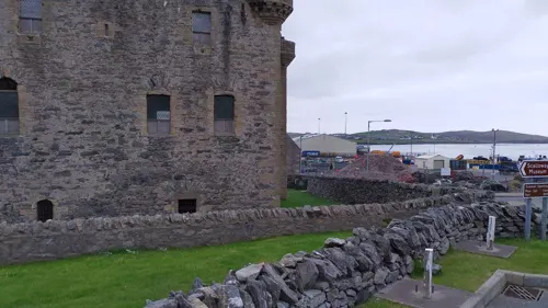
Scalloway Castle was built in 1600 by Patrick Stewart, 2nd Earl of Orkney. It was originally surrounded by water but due to land reclamation, that is no longer the case. The remains of the castle are the most notable feature of the village, located near the quay. (The castle is usually locked, but a key can be borrowed from the nearby Scalloway Hotel or from the adjacent Scalloway Museum.)
Norwegian boatbuilders from Hordaland, in the areas around Bergen, Os, and Tysnes, built yoals from about the 16th century. Oselvar, the traditional small wooden boat of Os, were taken apart and then 'flat packed' for shipping to Scalloway. Instead of sending complicated assembly instructions, they sent boatbuilders to rebuild them. Many of these stayed for years in Shetland, and some married there.
To the Hanseatic merchants from Bremen and Hamburg, Scalloway was known as Schaldewage, and as a good sheltered harbour on the route to Hillswick.
Barbara Tulloch and her daughter Ellen – probably the last witches to be burned in Shetland – were executed on Gallow Hill, overlooking the village in 1690. Scalloway Public Hall on Berry Road was completed in 1902.
Read more of the history
During the Second World War, Scalloway was the home base for, and housed for some time the headquarters of the Shetland Bus, part of the Norwegian resistance against the German occupation. It was operated by Norwegian Resistance and British Secret Service who ran small craft to Norway to assist the Norwegians. The Norway House and the Prince Olav Pier / slipway, which formed major parts of the base are still existing. Details of the history of The Shetland Bus are on display at the Scalloway Museum.
In 1996, Kåre Emil Iversen published his wartime memoirs, I Shetland Bus Man. It was reprinted in 2004, with a new introduction and the title Shetland Bus Man. Another Shetland author Willie Smith discusses this period extensively in his 2003 memoir Willie's War and Other Stories as does David Howarth in The Shetland Bus (first published in 1951, later printings up to 2018).
After the war Scalloway served as harbour of the Shetland-Orkney ferry service (MV Orcadia) on the Scalloway–Stromness route. After the opening of the Schiehallion oilfield off the west coast of Shetland, Scalloway took over some functions as a service base for the oil business.
From the History section of Scalloway on Wikipedia, under CC BY-SA 4.0.
More about Scalloway
Education
Scalloway is the location of the North Atlantic Fisheries College (part of the University of the Highlands and Islands), which offers courses and supports research programmes in fisheries sciences, aquaculture, marine engineering and coastal management. It is also home to the Centre for Nordic Studies. NAFC Marine Centre at Ness of Westshore offers courses in "nautical studies, marine science and technology, and seafood quality".
The village has a swimming pool and a primary school. Scalloway Junior High School, the secondary department, was closed by the Shetland Islands Council in July 2011.
From the Wikipedia article Scalloway, under CC BY-SA 4.0.
Where to stay3
Churches and places of worship1
Shopping1
Schools, colleges and libraries2
Healthcare1
Map of Scalloway
29 places. The map loads OpenStreetMap tiles when you open it.
Getting there and nearby towns
Tingwall Airport (LWK) is the nearest airport with scheduled flights listed in OpenStreetMap, 4 miles away.
- Lerwick 5 mi east, about 8 min by car
- Sandwick 10 mi south, about 15 min by car
- Symbister 17 mi northeast, about 27 min by car
- Brae 18 mi north, about 29 min by car
Drive times are estimates from straight-line distance, not routes.
Keep exploring
Local news
Headlines from INDB.
Reviews, tips and questions
Loading what members have shared...
Sources and licences
- GeoNames (CC BY 4.0): population, coordinates, regions and time zone
- Mapillary (see each image): photos
- OpenStreetMap contributors (ODbL 1.0): places, airports, map data
- Wikidata (CC0 1.0): elevation, founding date, time zone, website, landmarks and historic places
- Wikimedia Commons (see each image): photos
- Wikipedia (CC BY-SA 4.0): overview and history text
Photo credits
- Scalloway Castle (August 2013), Marion Timperley, CC BY-SA 3.0
- Scalloway Museum (front), Oliver Dixon, CC BY-SA 2.0
- Street-level photo, tallguy, CC BY-SA 4.0
- Street-level photo, tonys999, CC BY-SA 4.0
- Street-level photo, tonys999, CC BY-SA 4.0
- Street-level photo, tonys999, CC BY-SA 4.0
- Street-level photo, tonys999, CC BY-SA 4.0
- Street-level photo, tonys999, CC BY-SA 4.0
- Street-level photo, tallguy, CC BY-SA 4.0
- Street-level photo, tonys999, CC BY-SA 4.0
- Street-level photo, tonys999, CC BY-SA 4.0
- Street-level photo, tonys999, CC BY-SA 4.0
- Street-level photo, tallguy, CC BY-SA 4.0
Page built November 10, 2026. Spotted a mistake? Tell us or suggest a place.