


Why visit Glendale
Townapedia lists 15 museums and landmarks, 39 parks and trails, 54 places to eat, 6 places to stay and 4 attractions in and around town.
Highlights include University of Wisconsin–Milwaukee, The Argo, Albert and Edith Adelman House and Garden Homes Historic District.
July is the warmest month, with average highs of 83°F; January lows average 14°F, and about 40 inches of snow fall in a normal year.
Weather in Glendale
Forecast from the National Weather Service. Full forecast
About Glendale
Glendale is a city in Milwaukee County, Wisconsin, United States. The population was 13,357 at the 2020 census. A suburb north of Milwaukee, it is part of the Milwaukee metropolitan area.
From the Wikipedia article Glendale, Wisconsin (this version), under CC BY-SA 4.0.
Things to do4

University of Wisconsin–Milwaukee
School · 4.2 mi
University in Milwaukee

Museums and landmarks15

Albert and Edith Adelman House
Monument and historic site · National Register of Historic Places · 2.0 mi
United States historic place
7111 North Barnett Lane, Fox Point

Garden Homes Historic District
Monument and historic site · National Register of Historic Places · 2.2 mi
Historic district in Milwaukee, Wisconsin, United States
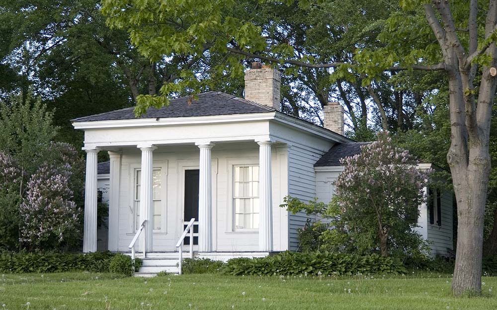
Benjamin Church House
Monument and historic site · National Register of Historic Places · 2.8 mi
Building in Shorewood, Wisconsin, USA

Congregation Beth Israel
Monument and historic site · National Register of Historic Places · 1.2 mi
Synagogue in Milwaukee, Wisconsin, United States

Herman Uihlein House
Monument and historic site · National Register of Historic Places · 1.9 mi
Historic house in Wisconsin, United States

Mary Nohl Art Environment
Monument and historic site · National Register of Historic Places · 2.4 mi
Artist's property and home transformed into a multidimensional art environment

Milwaukee-Downer "Quad"
Monument and historic site · National Register of Historic Places · 4.1 mi
Building complex in Milwaukee, Wisconsin, United States

North Sherman Boulevard Historic District
Monument and historic site · National Register of Historic Places · 4.2 mi
Historic district in Wisconsin, United States

Rufus Arndt House
Monument and historic site · National Register of Historic Places · 2.8 mi
United States historic place
Shorewood Village Hall
Monument and historic site · National Register of Historic Places · 3.4 mi
Village hall in Shorewood (Wisconsin, United States)


SS Appomattox
Monument and historic site · National Register of Historic Places · 3.8 mi
Largest wooden steamship on the Great Lakes wrecked in 1905
3 more on the map.
Parks, trails and playgrounds39


Estabrook Park
Park · 2.1 mi
Park in Milwaukee County, Wisconsin, United States of America
4400 Estabrook Parkway, Milwaukee
Garden Homes Square
Park · 2.2 mi
2600 West Atkinson Avenue, Milwaukee
Hubbard Park
Park · 3.5 mi
Listed as a Milwaukee County Historical Society landmark
Lynden Sculpture Garden
Park · 3.5 mi
Sculpture garden in Milwaukee, United States
McGovern Park
Park · 2.3 mi
5400 North 51st Boulevard, Milwaukee
27 more on the map.
Restaurants and cafes54

Starbucks
Cafe · Coffee Shop · 1.2 mi
6815 North Port Washington Road, Glendale
Mo-Fr 04:30-20:00; Sa-Su 05:30-20:00
Stone Creek Coffee
Cafe · Coffee Shop · 1.4 mi
6969 North Port Washington Road, Glendale
Mo-Sa 06:00-19:00; Su 07:00-19:00

Royal Garden Chinese Restaurant
Restaurant · Chinese · 0.9 mi
206 West Silver Spring Drive, Glendale
Mo-Th 11:00-20:30; Fr,Sa 11:00-21:00; Su 12:00-20:30
Crumbl Cookies
Cafe · Dessert · 0.8 mi
5600 North Bayshore Drive, Glendale
Mo-Su 08:00-22:00
Stone Creek Coffee
Cafe · Coffee Shop · 1.3 mi
527 East Silver Spring Drive, Whitefish Bay
Mo-Su 06:00-21:00
The Anchorage
Restaurant · Seafood · 1.7 mi
4700 North Port Washington Road, Glendale
Mo-Su 06:30-22:00

42 more on the map.
History
The Glendale area has been inhabited for thousands of years. The earliest known inhabitants were Woodland period Mound Builders, who constructed earthen effigy and burial mounds in the area. Many of the mounds were destroyed by farmers between 1850 and 1920, though some still exist in Kletzsch Park. In the early 19th century, the land was controlled by Native Americans, including the Menominee, Potawatomi, and Sauk people. The Menominee surrendered the land east of the Milwaukee River to the United States Federal Government through the Treaty of Washington in 1832. In 1833, the Potawatomi surrendered the land west of the river by signing the 1833 Treaty of Chicago, which (after being ratified in 1835) required them to leave Wisconsin by 1838.
The land was organized as part of the Town of Milwaukee in 1838, and the first white settlers were farmers, many of whom were German immigrants. One center of settlement was the Good Hope community, which formed as a stagecoach stop on Green Bay Road in the late 1840s and was a prosperous rural community with a tavern, a school, and a railroad station into the 1890s.
From the History section of Glendale, Wisconsin on Wikipedia, under CC BY-SA 4.0.
Where to stay6
Holiday Inn Milwaukee Riverfront Hotel
Motel and hotel · 1.7 mi
4700 North Port Washington Road, Glendale
La Quinta Inn & Suites Milwaukee Bayshore Area
Motel and hotel · 0.9 mi
5423 North Port Washington Road, Glendale
Residence Inn Milwaukee North/Glendale
Motel and hotel · 1.4 mi
7003 North Port Washington Road, Glendale
Fairfield Inn & Suites Milwaukee North
Motel and hotel · 1.5 mi
7035 North Port Washington Road, Glendale
Churches and places of worship18
Divinity-Divine Charity Evangelical Lutheran Church
Church · Evangelical Lutheran · 1.7 mi
900 East Henry Clay Street, Whitefish Bay
Bay Shore Lutheran Church
Church · Lutheran · 2.2 mi
1200 East Hampton Road, Whitefish Bay
Garden Homes Lutheran Church
Church · Lutheran · 2.3 mi
2450 West Roosevelt Drive, Milwaukee
Holy Temple Firstborn Missionary Baptist Church
Church · Baptist · 1.3 mi
4960 North 18th Street, Milwaukee
Jerusalem Baptist Church
Church · Baptist · 1.9 mi
2505 West Cornell Street, Milwaukee
Mason Temple Church of God in Christ
Church · Church Of God In Christ · 1.4 mi
6098 North 35th Street, Milwaukee
Our Savior Lutheran Church
Church · Lutheran · 1.0 mi
6021 North Santa Monica Boulevard, Whitefish Bay
St. Eugene Congregation
Church · Roman Catholic · 2.2 mi
7600 North Port Washington Road, Fox Point
The United Methodist Church of Whitefish Bay
Church · Methodist · 1.5 mi
819 East Silver Spring Drive, Whitefish Bay
Zion Hill Missionary Baptist Church
Church · Baptist · 1.6 mi
1815-1825 West Hampton Avenue, Milwaukee
Shopping18
Gas and EV charging8
Compressed Natural Gas Public Fueling Facility
Gas station · 2.3 mi
3100 West Congress Street, Milwaukee
Schools, colleges and libraries78
Healthcare13
Fresenius Medical Care Dialysis Center
Clinic and pharmacy · 2.1 mi
400 West Estabrook Boulevard, Glendale
Columbia St. Mary's Park Woods Campus
Clinic and pharmacy · 2.1 mi
375 West River Woods Parkway, Glendale
Fresenius Kidney Care
Clinic and pharmacy · 1.0 mi
2615 West Silver Spring Drive, Milwaukee
Silver Springs Healthcare Center
Clinic and pharmacy · 0.5 mi
1300 West Silver Spring Drive, Glendale
Map of Glendale
250 places. The map loads OpenStreetMap tiles when you open it.
Climate by month
Monthly table
| Month | High | Low | Rain | Snow |
|---|---|---|---|---|
| Jan | 30°F | 14°F | 1.5 in | 11.0 in |
| Feb | 34°F | 17°F | 1.5 in | 9.9 in |
| Mar | 44°F | 26°F | 1.8 in | 5.3 in |
| Apr | 56°F | 36°F | 3.7 in | 1.5 in |
| May | 68°F | 48°F | 3.7 in | 0.0 in |
| Jun | 78°F | 58°F | 4.8 in | 0.0 in |
| Jul | 83°F | 63°F | 3.6 in | 0.0 in |
| Aug | 81°F | 62°F | 3.7 in | 0.0 in |
| Sep | 74°F | 53°F | 3.0 in | 0.0 in |
| Oct | 61°F | 42°F | 2.7 in | 0.0 in |
| Nov | 47°F | 30°F | 2.0 in | 2.0 in |
| Dec | 35°F | 21°F | 1.7 in | 9.8 in |
U.S. Climate Normals 1991-2020 for Mt Mary College Hcn (6 mi away), NOAA NCEI.
People and cost of living
American Community Survey 5-year estimates, 2020-2024, U.S. Census Bureau. Estimates have margins of error, larger for small towns.
Disaster history
Milwaukee County has had 13 federal disaster declarations since 2000, most often for severe storms.
- 2026-06-30: Severe Storms, Tornadoes, And Flooding (Flood)
- 2025-09-11: Severe Storms, Straight-Line Winds, Flooding, And Mudslides (Flood)
- 2020-04-04: Covid-19 Pandemic (Biological)
- 2020-03-13: Covid-19 (Biological)
- 2020-03-11: Severe Winter Storm And Flooding (Flood)
- 2011-04-05: Severe Winter Storm And Snowstorm (Snowstorm)
OpenFEMA disaster declarations summaries.
Getting there and nearby towns
Lawrence J. Timmerman Airport (MWC) is the nearest airport with scheduled flights listed in OpenStreetMap, 6 miles away.
- Brown Deer 4 mi northwest, about 7 min by car
- Milwaukee 5 mi southwest, about 8 min by car
- Brookfield 11 mi southwest, about 17 min by car
- Germantown 12 mi northwest, about 20 min by car
- Cedarburg 12 mi north, about 20 min by car
- Cudahy 13 mi south, about 21 min by car
- Greendale 13 mi south, about 22 min by car
- Grafton 14 mi north, about 22 min by car
- Franklin 17 mi south, about 28 min by car
- Caledonia 23 mi south, about 37 min by car
Drive times are estimates from straight-line distance, not routes.
Local news
Headlines from INDB, the NEMICO news database.
Reviews, tips and questions
Loading what members have shared...
Sources and licences
- NCES EDGE (Public domain): public schools
- NOAA NCEI U.S. Climate Normals 1991-2020 (Public domain): climate by month
- OpenFEMA (Public domain): disaster declarations
- OpenStreetMap contributors (ODbL 1.0): places, airports, map data
- U.S. Census Bureau (Public domain): population, income, housing, education, commute
- Wikidata (CC0 1.0): elevation, founding date, time zone, website, landmarks and historic places
- Wikimedia Commons (see each image): photos
- Wikipedia (CC BY-SA 4.0): overview and history text
Photo credits
- Milwaukee Town Hall Oct11, Freekee, CC0
- Glendale August 2022 5 (2022 Sprecher Root Beer Bash at Bayshore), Michael Barera, CC BY-SA 4.0
- Glendale August 2022 2 (2022 Sprecher Root Beer Bash at Bayshore), Michael Barera, CC BY-SA 4.0
- Glendale August 2022 1 (2022 Sprecher Root Beer Bash at Bayshore), Michael Barera, CC BY-SA 4.0
- Glendale August 2022 3 (2022 Sprecher Root Beer Bash at Bayshore), Michael Barera, CC BY-SA 4.0
- Glendale August 2022 4 (2022 Sprecher Root Beer Bash at Bayshore), Michael Barera, CC BY-SA 4.0
- Glendale ArgyleAvePonds3, Aaron Volkening, CC BY 2.0
- Glendale ArgyleAvePonds2, Aaron Volkening, CC BY 2.0
- Glendale ArgyleAvePonds1, Aaron Volkening, CC BY 2.0
- Glendale August 2022 6 (Milwaukee River), Michael Barera, CC BY-SA 4.0
- Glendale August 2022 8 (Sprecher Brewery), Michael Barera, CC BY-SA 4.0
- Garden Homes Hist Dist Mar10, Freekee, Public domain
- Landmk-0904-adelmann, Freekee at English Wikipedia, Public domain
- Beth-Israel-Syn Mar10, Freekee, Public domain
- Benchurchhouse-May09, Freekee, CC BY-SA 3.0
- Appomattox, Unknown author Unknown author, Public domain
- UWM-0904-downer-quad, Freekee at English Wikipedia, Public domain
- UWM-0904-greenemuseum, Freekee at English Wikipedia, Public domain
- Landmk-0904-uilein, Freekee at English Wikipedia, Public domain
- Sherman Blvd Dist Mar10, Freekee, Public domain
- Mary-Nohl-House-May09, The original uploader was Freekee at English Wikipedia ., CC BY-SA 3.0
- Kletzsch Park Waterfall (49688166021), Joseph Gage from Yorkville, IL, USA, CC BY-SA 2.0
- Kletzsch Park Waterfall (49688169676), Joseph Gage from Yorkville, IL, USA, CC BY-SA 2.0
- Kletzsch Park Waterfall (49688169871), Joseph Gage from Yorkville, IL, USA, CC BY-SA 2.0
- Kletzsch Park Waterfall (49688171086), Joseph Gage from Yorkville, IL, USA, CC BY-SA 2.0
- Kletzsch Park Waterfall (49688475772), Joseph Gage from Yorkville, IL, USA, CC BY-SA 2.0
- Kletzsch Park Waterfall (49688476012), Joseph Gage from USA, CC BY-SA 2.0
- Kletzsch Park Waterfall (49687636763), Joseph Gage from Yorkville, IL, USA, CC BY-SA 2.0
- Kletzsch Park Waterfall (49688171286), Joseph Gage from Yorkville, IL, USA, CC BY-SA 2.0
- Kletzsch Park Waterfall (49688170341), Joseph Gage from USA, CC BY-SA 2.0
- Kletzsch Park Waterfall (49688170961), Joseph Gage from Yorkville, IL, USA, CC BY-SA 2.0
- Kletzsch Park Waterfall (49688170151), Joseph Gage from Yorkville, IL, USA, CC BY-SA 2.0
- Kletzsch Park Waterfall (49688166221), Joseph Gage from Yorkville, IL, USA, CC BY-SA 2.0
- Kletzsch Park Waterfall (49688165901), Joseph Gage from Yorkville, IL, USA, CC BY-SA 2.0
- Milwaukee River Pkwy 1-Apr-17, Freekee, CC BY-SA 4.0
- Bayshore Town Center (313579511), Ashe Dryden from Madison, WI, United States, CC BY 2.0
- Elderwood, Boscophotos, CC BY-SA 3.0
- Breakfast - 46084994635, Mary Kreul, CC BY-SA 2.0
- WITI WCGV-TV Original Studio, MrSchimpf, CC BY-SA 4.0
- Panorama take at Klode Park overlooking the lake, brennanMKE, CC BY-SA 2.0


Page built October 30, 2026. Spotted a mistake? Tell us or suggest a place.