


Hyattsville, Maryland
Hyattsville is a city of 20,966 people in Prince George's County, Maryland.
Why visit Hyattsville
Townapedia lists 70 museums and landmarks, 65 parks and trails, 137 places to eat, 1 place to stay and 17 attractions in and around town.
Highlights include Amtrak Railroad Anacostia Bridge, Bladensburg Park Pedestrian Bridge, Riversdale House Museum and Mount Rainier Historic District.
July is the warmest month, with average highs of 90°F; January lows average 28°F.
Weather in Hyattsville
Forecast from the National Weather Service. Full forecast
About Hyattsville
Hyattsville is a city in Prince George's County, Maryland, United States. It is an urban suburb of Washington, D.C. The population was 21,187 at the 2020 United States census.
From the Wikipedia article Hyattsville, Maryland (this version), under CC BY-SA 4.0.
Things to do17

Amtrak Railroad Anacostia Bridge
Bridge · 3.1 mi
Bridge in United States of America
Bladensburg Park Pedestrian Bridge
Bridge · 1.9 mi
Bicycle and pedestrian bridge over the Anacostia River in the U.S. state of Maryland
Bladensburg Road Bridge
Bridge · 1.7 mi
Bridge in Prince George's County, Maryland, United States
Carroll Avenue Bridge
Bridge · 2.9 mi
Bridge in Takoma Park, Maryland, United States

Clarice Smith Performing Arts Center
Cinema and theater · 2.1 mi
Theater and concert hall of the University of Maryland in College Park, Maryland, United States
New York Avenue Bridge
Bridge · 3.1 mi
Bridge crossing over the Anacostia River in Washington, D.C.

School of Nursing at The Catholic University of America
School · 3.0 mi
Nursing school of Washington, D.C., U.S
Trinity Washington University
School · 3.6 mi
Catholic university in Washington, D.C.
University of Maryland
School · 2.0 mi
Public research university in the city of College Park in Prince George's County, Maryland, USA
University of Maryland Global Campus
School · 1.7 mi
One of 11 degree-granting institutions within the University System of Maryland
Washington Adventist University
School · 3.0 mi
University in Takoma Park, Maryland, United States
5 more on the map.
Museums and landmarks70

Riversdale House Museum
Museum · 1.2 mi
4811 Riverdale Road, Riverdale Park
Mo-Fr 10:00-16:00; Su 11:30-15:30
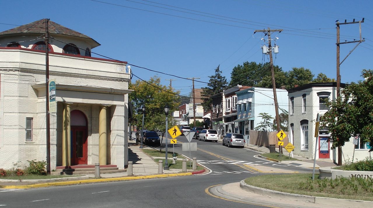
Mount Rainier Historic District
Monument and historic site · National Register of Historic Places · 1.6 mi
Historic district located in Mount Rainier, Maryland

Adams Memorial
Monument and historic site · National Register of Historic Places · 3.1 mi
Artwork by Augustus Saint-Gaudens
Armed Forces Retirement Home-Washington
Monument and historic site · National Register of Historic Places · 3.4 mi
United States historic place
Ash Hill
Monument and historic site · National Register of Historic Places · 1.3 mi
House in Hyattsville, Maryland, United States
Bostwick
Monument and historic site · National Register of Historic Places · 1.9 mi
Historic home located at Bladensburg
Brooks Mansion
Monument and historic site · National Register of Historic Places · 2.9 mi
Greek Revival plantation house
Cady-Lee
Monument and historic site · National Register of Historic Places · 3.6 mi
Historic house in Washington, D.C., United States
Calvert Hills Historic District
Monument and historic site · National Register of Historic Places · 1.4 mi
Historic district in Maryland, United States
Children's Country Home
Monument and historic site · National Register of Historic Places · 1.8 mi
Hospital

College Heights Estates Historic District
Monument and historic site · National Register of Historic Places · 1.1 mi
Historic district in Maryland, United States
College Park Airport
Monument and historic site · National Register of Historic Places · 2.2 mi
Airport in College Park, Maryland, United States
58 more on the map.
Parks, trails and playgrounds65

Kenilworth Park and Aquatic Gardens
Park · National Register of Historic Places · 3.6 mi
Park in Washington, D.C., United States


United States National Arboretum
Park · National Register of Historic Places · 3.6 mi
National arboretum and research institution in Washington, D.C., US

Bladensburg Dueling Grounds
Park · 2.6 mi
Site where more than 50 duels were fought during the 1800s in Maryland, US
Greenbelt Park
Park · 3.4 mi
Park in Greenbelt, Maryland, managed by the United States National Park Service
McKeldin Mall
Park · 1.8 mi
Green space at the University of Maryland, College Park campus
53 more on the map.
Restaurants and cafes137

Pizzeria Paradiso
Restaurant · Pizza · 1.1 mi
Casual restaurant with a central oven for wood-fired pizzas has a vast menu of international beers.
4800 Rhode Island Avenue, Hyattsville
We-Th 16:00-21:00; Fr-Su 13:00-21:00
Aroy Thai Restaurant
Restaurant · Thai · 1.7 mi
4511 College Avenue, College Park
Mo-Fr 11:30-22:00; Sa 12:00-22:00; Su 16:30-22:00
Carolina Kitchen Bar & Grill
Restaurant · Regional · 0.5 mi
6501 America Boulevard, Hyattsville
Su-Th 11:00-22:00, Fr-Sa 11:00-24:00
Cocineros
Restaurant · Latin American · 0.4 mi
3513 East-West Highway, Hyattsville
Mo-Th 11:00-21:00; Fr 11:00-22:00; Sa-Su 10:00-22:00

Mid Atlantic Seafood
Restaurant · Fish · 1.1 mi
3100 Queens Chapel Road, Hyattsville
Mo-Th,Sa 10:00-21:00; Fr 10:00-21:30; Su 11:00-21:00
Noodles & Company
Restaurant · Pasta · 1.6 mi
7320 Baltimore Avenue, College Park
Mo-Th,Su 10:30-22:00; Fr-Sa 10:30-23:00

Old Dominion Brew House
Bar and pub · American · 0.5 mi
6404 America Boulevard, Hyattsville
Su-Tu 11:00-23:00, We 11:00-24:00, Th 11:00-23:00, Fr-Sa 11:00-24:00
Outback Steakhouse
Restaurant · American, Steak · 0.4 mi
3500 East-West Highway, Hyattsville
Mo-Th 11:00-22:00; Fr,Sa 11:00-23:00; Su 11:00-21:00
Pennyroyal Station
Restaurant · Comfort Food · 1.7 mi
3310 Rhode Island Avenue, Mount Rainier
We-Fr 11:00-14:30, Tu-Th 16:00-21:00, Fr,Sa 17:00-22:00, Su...
QU Japan
Restaurant · Hibachi · 1.6 mi
7406 Baltimore Avenue, College Park
Mo-Sa 11:00-21:30; Su 12:00-21:30
Riviera Tapas Bar
Restaurant · Tapas · 1.0 mi
6202 Rhode Island Ave, Riverdale Park
Mo-Tu 16:00-21:00; We 16:00-22:00; Th-Sa 11:00-22:00; Su 11:00-21:00
125 more on the map.
History
In the 1720s, John Beall acquired land in the area and established Beall Town. The opening of the Washington–Baltimore Turnpike (modern day US 1) in 1812 and the B&O Railroad Washington Branch line in 1835 brought more settlers to the area.
The city's founder, Christopher Clark Hyatt (1799–1884), purchased his first parcel of land in the area in 1845. Hyatt opened a store and began mail delivery, officially naming the nascent community "Hyattsville" in his 1859 application to become postmaster. In the years following the Civil War, Hyatt and other local landowners subdivided their properties and sold lots, and the population of Hyattsville grew. Hyattsville was incorporated as a city on April 7, 1886.
In 1893, the Hyattsville Board of Commissioners changed their property tax to only apply to the value of land, and not improvements. Opponents of this brought the action to court, and, after an appeal, the Maryland Court of Appeals found it to violate the Maryland constitution and struck it down.
From the History section of Hyattsville, Maryland on Wikipedia, under CC BY-SA 4.0.
Where to stay1
Churches and places of worship56
Kingdom Hall of Jehovah’s Witnesses
Place of worship · Jehovahs Witness · 1.0 mi
6100 Ager Road, Hyattsville
Kingdom Hall of Jehovah’s Witnesses
Place of worship · Jehovahs Witness · 1.8 mi
6517 Truman Road, Hyattsville
Shopping26
Gas and EV charging17
Schools, colleges and libraries77
Healthcare11
Prince George's Medical Center
Clinic and pharmacy · 0.6 mi
6525 Belcrest Road, Hyattsville
Kaiser Permanente West Hyattsville Medical Center
Clinic and pharmacy · 0.7 mi
5320 Ager Road, Hyattsville
Map of Hyattsville
250 places. The map loads OpenStreetMap tiles when you open it.
Climate by month
Monthly table
| Month | High | Low | Rain | Snow |
|---|---|---|---|---|
| Jan | 45°F | 28°F | 3.0 in | 4.7 in |
| Feb | 48°F | 30°F | 2.8 in | 2.3 in |
| Mar | 56°F | 36°F | 4.0 in | 1.4 in |
| Apr | 68°F | 46°F | 3.4 in | 0.0 in |
| May | 77°F | 57°F | 4.3 in | 0.0 in |
| Jun | 85°F | 66°F | 4.6 in | 0.0 in |
| Jul | 90°F | 71°F | 4.6 in | 0.0 in |
| Aug | 88°F | 69°F | 3.7 in | 0.0 in |
| Sep | 82°F | 62°F | 4.1 in | 0.0 in |
| Oct | 70°F | 49°F | 4.2 in | 0.0 in |
| Nov | 58°F | 39°F | 3.2 in | 0.0 in |
| Dec | 49°F | 32°F | 3.7 in | 1.3 in |
U.S. Climate Normals 1991-2020 for Natl Arboretum Dc (3 mi away), NOAA NCEI.
People and cost of living
American Community Survey 5-year estimates, 2020-2024, U.S. Census Bureau. Estimates have margins of error, larger for small towns.
Disaster history
Prince George's County has had 13 federal disaster declarations since 2000, most often for hurricanes.
- 2026-01-24: Severe Winter Storm (Winter Storm)
- 2020-03-26: Covid-19 Pandemic (Biological)
- 2020-03-13: Covid-19 (Biological)
- 2016-03-04: Severe Winter Storm And Snowstorm (Snowstorm)
- 2012-11-20: Hurricane Sandy (Hurricane)
- 2012-10-28: Hurricane Sandy (Hurricane)
OpenFEMA disaster declarations summaries.
Getting there and nearby towns
College Park Airport (CGS) is the nearest airport with scheduled flights listed in OpenStreetMap, 2 miles away.
- Chillum 1 mi west, about 2 min by car
- East Riverdale 2 mi east, about 4 min by car
- College Park 3 mi north, about 4 min by car
- Adelphi 3 mi north, about 4 min by car
- Greenbelt 4 mi northeast, about 7 min by car
- Washington 5 mi southwest, about 8 min by car
- Beltsville 6 mi north, about 9 min by car
- Calverton 7 mi north, about 11 min by car
- Fairland 8 mi north, about 13 min by car
- Colesville 8 mi north, about 13 min by car
Drive times are estimates from straight-line distance, not routes.
Local news
Headlines from INDB, the NEMICO news database.
Reviews, tips and questions
Loading what members have shared...
Sources and licences
- NCES EDGE (Public domain): public schools
- NOAA NCEI U.S. Climate Normals 1991-2020 (Public domain): climate by month
- OpenFEMA (Public domain): disaster declarations
- OpenStreetMap contributors (ODbL 1.0): places, airports, map data
- U.S. Census Bureau (Public domain): population, income, housing, education, commute
- Wikidata (CC0 1.0): elevation, founding date, time zone, website, landmarks and historic places
- Wikimedia Commons (see each image): photos
- Wikipedia (CC BY-SA 4.0): overview and history text
Photo credits
- Prince Georges Plaza, Hyattsville, Maryland (2893471197), Ken Lund from Las Vegas, Nevada, USA, CC BY-SA 2.0
- Clark Bedford's Vanadu, Art Environment, Hyattsville, MD, Marcus O. Bst from Hinterland, Germany, CC BY-SA 2.0
- Northbound train leaving Hyattsville Crossing station, May 2025, Pi.1415926535, CC BY-SA 4.0
- Fare lobby at Hyattsville Crossing station, May 2025, Pi.1415926535, CC BY-SA 4.0
- Hyattsville Crossing platforms from mezzanine, May 2025, Pi.1415926535, CC BY-SA 4.0
- Platforms at Hyattsville Crossing station, May 2025, Pi.1415926535, CC BY-SA 4.0
- Northbound train at Hyattsville Crossing station, May 2025, Pi.1415926535, CC BY-SA 4.0
- Portal at west end of Hyattsville Crossing station, May 2025, Pi.1415926535, CC BY-SA 4.0
- First United Methodist Church of Hyattsville (54421864468), Maryland GovPics, CC BY 2.0
- Hyattsville Maryland 08, Bohemian Baltimore, CC BY-SA 4.0
- Hyattsville Maryland 06, Bohemian Baltimore, CC BY-SA 4.0
- Hyattsville Maryland 03, Bohemian Baltimore, CC BY-SA 4.0
- Hyattsville Maryland 38, Bohemian Baltimore, CC BY-SA 4.0
- Hyattsville Maryland 20, Bohemian Baltimore, CC BY-SA 4.0
- Hyattsville Maryland 10, Bohemian Baltimore, CC BY-SA 4.0
- Hyattsville Maryland 42, Bohemian Baltimore, CC BY-SA 4.0
- Hyattsville Maryland 39, Bohemian Baltimore, CC BY-SA 4.0
- Hyattsville Maryland 16, Bohemian Baltimore, CC BY-SA 4.0
- Hyattsville Maryland 37, Bohemian Baltimore, CC BY-SA 4.0
- Hyattsville Maryland 24, Bohemian Baltimore, CC BY-SA 4.0
- Hyattsville Maryland 04, Bohemian Baltimore, CC BY-SA 4.0
- Hyattsville Maryland 29, Bohemian Baltimore, CC BY-SA 4.0
- Hyattsville Maryland 22, Bohemian Baltimore, CC BY-SA 4.0
- Hyattsville Maryland 34, Bohemian Baltimore, CC BY-SA 4.0
- Hyattsville Maryland 40, Bohemian Baltimore, CC BY-SA 4.0
- Hyattsville Maryland 17, Bohemian Baltimore, CC BY-SA 4.0
- Hyattsville Maryland 26, Bohemian Baltimore, CC BY-SA 4.0
- Hyattsville Maryland 05, Bohemian Baltimore, CC BY-SA 4.0
- Hyattsville Maryland 01, Bohemian Baltimore, CC BY-SA 4.0
- Hyattsville Maryland 33, Bohemian Baltimore, CC BY-SA 4.0
- Hyattsville Maryland 07, Bohemian Baltimore, CC BY-SA 4.0
- Hyattsville Maryland 30, Bohemian Baltimore, CC BY-SA 4.0
- Hyattsville Maryland 21, Bohemian Baltimore, CC BY-SA 4.0
- Hyattsville Maryland 09, Bohemian Baltimore, CC BY-SA 4.0
- US Route 1 & 34th St, Mt. Rainier, Maryland, Nonvirtual, CC BY-SA 3.0
- Kenilworthgarden1, Jennifer Boyer from Maryland, USA, CC BY 2.0
- Visitors Center & Administration Building - United States National Arboretum, Cliff from Arlington, Virginia, USA, CC BY 2.0
- Takoma Park hd, Farragutful, CC BY-SA 3.0
- Leland Hospital Sept 09, Pubdog ( talk ), Public domain
- College Heights Estates Historic District 07, Farragutful, CC BY-SA 4.0


Page built October 30, 2026. Spotted a mistake? Tell us or suggest a place.