


Batu, Indonesia
Batu is a town of 225,408 people in East Java, Indonesia, founded in October 17, 2001.
Why visit Batu
Townapedia lists 35 museums and landmarks, 55 parks and trails, 74 places to eat, 54 places to stay and 50 attractions in and around town.
Highlights include Toko Buah Icha Fruits, Brawijaya University, Museum Angkut and Museum D'Topeng Kingdom.
Weather in Batu
Forecast from MET Norway (CC BY 4.0). Full forecast
About Batu
Batu, officially the City of Batu (Indonesian: Kota Batu, Javanese: ꦏꦸꦛꦧꦠꦸ, romanized: Kutha Batu), is a city in the East Java Province of Indonesia. It is about 20 km to the northwest of Malang. Formerly, it was a part of Malang Regency; but in June 2001, Batu became an independent city (by Act No. 11 of 2001), with its own mayor and council.
From the Wikipedia article Batu, Indonesia (this version), under CC BY-SA 4.0.
Travel tips from other travellers: Batu on Wikivoyage (CC BY-SA 4.0).
Things to do50


Brawijaya University
School · 13.1 km
National university in East Java, Indonesia
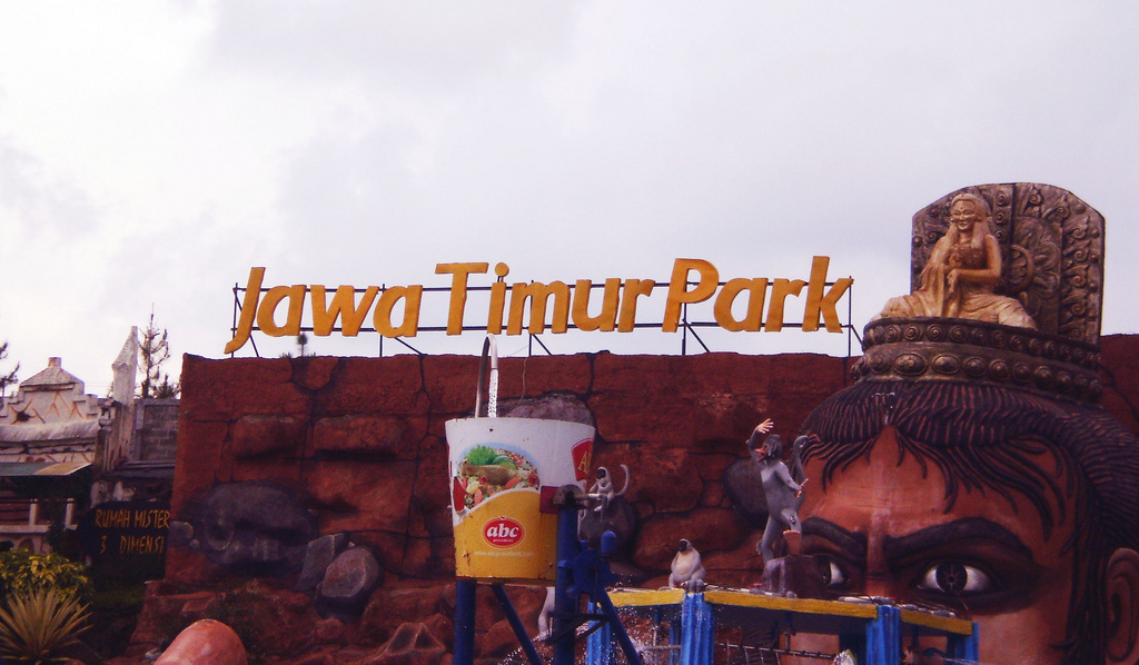
Jawa Timur Park
Monument and historic site · 1.6 km
Amusement park complex in Batu, East Java, Indonesia
Ma Chung University
School · 11.8 km
Higher education institution in Malang, Indonesia
State Polytechnic of Malang
School · 12.8 km
Higher education institution in Malang, Indonesia
State University of Malang
School · 14.3 km
National university in East Java, Indonesia


Gunung Kawi (Puncak Redi Kawi)
Scenic view · 10.0 km
Puncak Redi Kawi (Bukan Buthak), Puncak tugu


38 more on the map.
Museums and landmarks35

Museum Angkut
Museum · 1.4 km
Transportation museum in East Java
Jalan Terusan Sultan Agung, Batu



Omah Budaya Slamet Batu
Museum · 1.4 km
90 Jalan Imam Bonjol, Batu

Coban Rais Flower Garden
Monument and historic site · 4.6 km
Oro-Oro Ombo, Kehutanan, Kec
Desa Wisata Pujon Kidul
Monument and historic site · 8.2 km
Kawasan Wisata Cafe Sawah Desa Wisata Pujonkidul, Malang
23 more on the map.
Parks, trails and playgrounds55



Jawa Timur Park 1
Sports field and stadium · 1.6 km
2 Jl. Kartika, Batu

Smoking Area Saxofone Land
Park · 11.2 km
Perum Saxofone Land, RT 02 RW 11, Kel. Jatimulyo Kec. Lowokwaru Kota Malang
24/7
Taman GLT (Graha Laksana Tidar)
Park · 11.0 km
Perumahan Graha Laksana Tidar, Malang
43 more on the map.
Restaurants and cafes74

Crazy Steak by Pabrik Kopi - Villa Spa Resort Glamping
Cafe · Coffee Shop, Steak House, Chinese, Indonesian, International · 4.2 km
Jalan Alternatif Batu - Malang, Batu
24/7

CW Coffee & Eatery - Tlogomas
Cafe · 10.1 km
10 Jl. Raya Tlogomas No.10, Tlogomas, Kec. Lowokwaru, Kota Malang, Jawa Timur 65144
24/7
Warung Bethania Batu
Restaurant · Indonesian, Chicken, Fish
103 Jalan Diponegoro, Batu
62 more on the map.
History
Since the 10th century, the area of Batu and its surroundings has been known as a resting place for the royal family, because the region is a mountainous area with comfortable air, also supported by the beauty of natural scenery as a characteristic of mountainous regions.
During the reign of the Mataram Kingdom under King Sindok, a royal official named Mpu Supo was ordered by the King to build a royal family resting place in the mountains with nearby water springs. With a hard effort, finally Mpu Supo discovered an area that is now better known as the tourist area of Songgoriti. With the approval of King Sindok, Mpu Supo began to build the Songgoriti area as a royal family retreat and built a temple named Supo Temple.
Some local community leaders said that the title Batu comes from the name of a cleric follower of Prince Diponegoro named Abu Ghonaim referred to as the Kyai Gubug Angin which later the local community was familiar with calling Mbah Wastu. From Javanese cultural habits that often shorten and shorten the designation of someone's name which is considered too long, also to make it shorter and faster when calling someone, finally Mbah Wastu is called Mbah Tu to be Mbatu or Batu as a term used for a mild climate city in East Java.
From the History section of Batu, Indonesia on Wikipedia, under CC BY-SA 4.0.
Where to stay54
Churches and places of worship137
Masjid Baitul Muttaqin
Place of worship · 10.9 km
Perum Graha Laksana Tidar, Malang
Masjid Brigjend Soegiono
Place of worship · W · 1.8 km
507 Jalan Panglima Besar Sudirman, Batu
Shopping15
Gas and EV charging11
Schools, colleges and libraries94
Healthcare33
Map of Batu
250 places. The map loads OpenStreetMap tiles when you open it.
Getting there and nearby towns
Bandar Udara Abdul Rachman Saleh (MLG) is the nearest airport with scheduled flights listed in OpenStreetMap, 21 km away.
- Malang 17 km southeast, about 17 min by car
- Singosari 15 km east, about 15 min by car
- Lawang 19 km east, about 19 min by car
- Pakisaji 23 km south, about 23 min by car
- Prigen 23 km northeast, about 23 min by car
- Mojokerto 46 km north, about 46 min by car
- Pasuruan 49 km northeast, about 49 min by car
- Kediri 57 km west, about 57 min by car
- Surabaya 73 km north, about 1 h 15 min by car
- Probolinggo 77 km east, about 1 h 15 min by car
Drive times are estimates from straight-line distance, not routes.
Local news
Headlines from INDB.
Reviews, tips and questions
Loading what members have shared...
Sources and licences
- GeoNames (CC BY 4.0): population, coordinates, regions and time zone
- OpenStreetMap contributors (ODbL 1.0): places, airports, map data
- Wikidata (CC0 1.0): elevation, founding date, time zone, website, landmarks and historic places
- Wikimedia Commons (see each image): photos
- Wikipedia (CC BY-SA 4.0): overview and history text
Photo credits
- Alun-alun Batu, Rochelimit, CC BY-SA 4.0
- Grand Mosque at Batu Town Square; Prayitno; November 2013, Prayitno / Thank you for (12 millions +) view from Los Angeles, USA, CC BY 2.0
- Batu banner, Rochelimit, CC BY-SA 4.0
- 2017 Honda CR-V 1.5 Turbo Prestige (rear), Batu City, Alex Neman, CC BY-SA 4.0
- 2017 Honda CR-V 1.5 Turbo Prestige (front), Batu City, Alex Neman, CC BY-SA 4.0
- Candi Badut, 111org, CC BY-SA 4.0
- East Java Park, Batu, Malang, Annisa Alwita from Malang, Indonesia, CC BY-SA 2.0
- Museum angkut, Fathiya Rahmani, CC BY-SA 4.0
- Museum Satwa Jatim Park 2 2017-09-18, consigliere ivan from Bontang, Indonesia, CC BY 2.0
- Batu Night Spectacular Main Entrance, Medelam, CC BY-SA 4.0
- Batu大草坡, RoyeN, CC BY-SA 4.0
- Banyak Wajah dan Satu Bentuk Peduli, Penguinsprings, CC BY-SA 4.0
- Masuk kawasan alun2 - panoramio, snrtindar, CC BY-SA 3.0
- Apel raksasa - panoramio, snrtindar, CC BY-SA 3.0
- Spongebob at a Mosque, Linus Follert, CC BY-SA 2.0
- Traditional herbal medicine of Jamu, Wisnu Bangun Saputro, CC BY-SA 4.0
- Mawar Putih, Anastasia Ayu L, CC BY-SA 4.0
- Touring Van (26696558710), Thank You (25 Millions ) views from Fresno, USA, CC BY 2.0
- Classic Ford (26327718543), Thank You (25 Millions ) views from Fresno, USA, CC BY 2.0
- 1931 FORD Model A ( 3300 cc ) (26946798535), Thank You (25 Millions ) views from Fresno, USA, CC BY 2.0
- 1967 BEMO ~ Trimobile made by Daihatsu, Japan (26297092124), Thank You (25 Millions ) views from Fresno, USA, CC BY 2.0
- 1926 Ford Model T (2900 cc) (26658912240), Thank You (25 Millions ) views from Fresno, USA, CC BY 2.0
- 1957 Bentley S1 (26981110131), Thank You (25 Millions ) views from Fresno, USA, CC BY 2.0
- 1928 Graham-Paige 610 ( 3129 cc ) (26341424084), Prayitno / Thank you for (12 millions +) view from Los Angeles, USA, CC BY 2.0
- Pasar Apung = Floating Market = (27093012445), Thank You (25 Millions ) views from Fresno, USA, CC BY 2.0
- 1936 CHEVROLET Standard Six ( 3389 cc ) (26998513971), Thank You (25 Millions ) views from Fresno, USA, CC BY 2.0
- BSA Motorcycle (26832598065), Thank You (25 Millions ) views from Fresno, USA, CC BY 2.0
- Dokar or Bendi = pulled by a horse = (26605475810), Thank You (25 Millions ) views from Fresno, USA, CC BY 2.0
- 1932 Riley-9 Monaco ( 1098 cc ) (26947260195), Thank You (25 Millions ) views from Fresno, USA, CC BY 2.0
- Cikar (pronounce Chi~Car) = pulled by couple cows (26785259332), Thank You (25 Millions ) views from Fresno, USA, CC BY 2.0
- 1979 ROLLS ROYCE Silver Shadow ( 6750 cc ) (26955079642), Thank You (25 Millions ) views from Fresno, USA, CC BY 2.0
- BSA Motorcycle (26758830281), Thank You (25 Millions ) views from Fresno, USA, CC BY 2.0
- BSA Motorcycle (26559862340), Thank You (25 Millions ) views from Fresno, USA, CC BY 2.0
- Bajaj in Indonesian Transportation Museum, Indonesia; Prayitno; April 2016, Prayitno / Thank you for (12 millions +) view from Los Angeles, USA, CC BY 2.0
- Vespa Made In Italy model from 1962 - 1982 (26954984976), Thank You (25 Millions ) views from Fresno, USA, CC BY 2.0
- Motorized Bicycle ~ Made in China (26207934473), Thank You (25 Millions ) views from Fresno, USA, CC BY 2.0
- Rik-Shaw = pulled by a man = (26810796671), Thank You (25 Millions ) views from Fresno, USA, CC BY 2.0
- 2005 Toyota Avanza 1.3 G (front), Malang, Alex Neman, CC BY-SA 4.0
- 2005 Toyota Avanza 1.3 G (rear), Malang, Alex Neman, CC BY-SA 4.0
- 2005 Toyota Avanza 1.3 G (side), Malang, Alex Neman, CC BY-SA 4.0
- Batu pemandangan dari Paralayang Gunung Banyak, Prayitno / Thank you for (12 millions +) view from Los Angeles, USA, CC BY 2.0
- Batu Secret Zoo entrance pavilion, Rochelimit, CC BY-SA 4.0


Page built November 3, 2026. Spotted a mistake? Tell us or suggest a place.