


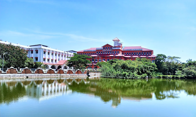


Why visit Pāppinisshēri
Townapedia lists 12 parks and trails, 12 places to eat, 3 places to stay and 4 attractions in and around town.
Highlights include Kannur University, Meenkunnu Beach and Parassinikkadavu Snake Park.
Weather in Pāppinisshēri
Forecast from MET Norway (CC BY 4.0). Full forecast
About Pāppinisshēri
Pappinisseri is a census town in Kannur district in the Indian state of Kerala. Pappinisseri Grama Panchayat has been recognized multiple times in the Kerala government's Swaraj Trophy awards for best-performing local bodies. It secured the third position for 2015–2016, and won the award consecutively from 2017–2018 to 2021. The panchayat was also declared the best Grama Panchayat in the state by the Government of Kerala.
From the Wikipedia article Pappinisseri (this version), under CC BY-SA 4.0.
Things to do4
Kannur University
School · 3.9 km
State public university in Kannur, Kerala, India


Parks, trails and playgrounds12


Parassinikkadavu Snake Park
Park · 6.5 km
Snake Park in Kerala, south India



Restaurants and cafes12

Keechery Sweet Center
Bakery · 1.8 km
Kasargod-Kannur-Calicut Highway
Mo-Su 07:00-22:30

kannur kudumbasreenano market
Restaurant · Asian, Chicken, Ice Cream, Indian · 3.6 km
Mo,Tu,Th,Fr 09:00-12:00,13:30-18:30; We 09:00-12:00,13:30-20:00;...
coolbar
Bakery · 3.7 km
Mo,Tu,Th,Fr 09:00-12:00,13:30-18:30; We 09:00-12:00,13:30-20:00;...
juice and shake
Restaurant · 1.8 km
Mo-Sa 09:00-12:00,13:30-18:30; Sa 09:00-17:00; PH closed


kl 13 fast food
Fast food · Chinese, Arab, Chicken · 3.7 km
Mo-Su 09:00-18:30; We 09:00-20:00; Sa 09:00-17:00; PH closed
Where to stay3

Churches and places of worship53
Chechini valappu Theepottan Kavu
Place of worship · 2.3 km
Thuruthi, pappinisseri
Pazhanchira Badar Juma Musjid
Place of worship · 1.1 km
PAZHANCHIRA-KOLATHUVAYAL ROAD, kannur
Shopping19
Gas and EV charging7
Schools, colleges and libraries90
Deshapriya vayanashala, Pallikunumbram
Library · 3.4 km
Pallikunnumbram Road, Azhikode
GR Fisheries Technical Vocational Higher Secondary School, Azhikkal
School · 3.5 km
Healthcare15
Neethi Medical Store
Clinic and pharmacy · 3.7 km
Kasargod-Kannur-Calicut Highway, KANNUR
Map of Pāppinisshēri
215 places. The map loads OpenStreetMap tiles when you open it.
Getting there and nearby towns
Kannur International Airport (CNN) is the nearest airport with scheduled flights listed in OpenStreetMap, 23 km away.
- Kalliyasshēri 3 km northeast, about 3 min by car
- Azhikkōd 4 km south, about 4 min by car
- Azhikkal 4 km southwest, about 4 min by car
- Kannapuram 5 km northwest, about 5 min by car
- Chirakkal 5 km southeast, about 5 min by car
- Taliparamba 10 km north, about 10 min by car
- Irikkūr 23 km east, about 23 min by car
- Tellicherry 29 km southeast, about 29 min by car
- Panoor 34 km southeast, about 34 min by car
- Kanhangad 47 km northwest, about 47 min by car
Drive times are estimates from straight-line distance, not routes.
Local news
Headlines from INDB.
Reviews, tips and questions
Loading what members have shared...
Sources and licences
- GeoNames (CC BY 4.0): population, coordinates, regions and time zone
- OpenStreetMap contributors (ODbL 1.0): places, airports, map data
- Wikidata (CC0 1.0): elevation, founding date, time zone, website, landmarks and historic places
- Wikimedia Commons (see each image): photos
- Wikipedia (CC BY-SA 4.0): overview and history text
Photo credits
- Mangroves park pappinisseri1, Ks.mini, CC BY-SA 3.0
- Meenkunnu Beach, Sreejithk2000, CC BY-SA 3.0
- Parassinikkadavu Snake Park, Pradeep717, CC BY-SA 3.0
- Kannur Univerisity Thavakkara Campus, Rahul B Ashok, CC0
- Lights in warm, Amruthjith, CC BY 4.0
- Wiki Loves Folklore Workshop 2025 Kannur 61, Manojk, CC BY-SA 4.0
- Wiki Loves Folklore Workshop 2025 Kannur 58, Manojk, CC BY-SA 4.0
- Wiki Loves Folklore Workshop 2025 Kannur 62, Manojk, CC BY-SA 4.0
- Wiki Loves Folklore Workshop 2025 Kannur 63, Manojk, CC BY-SA 4.0
- Wiki Loves Folklore Workshop 2025 Kannur 60, Manojk, CC BY-SA 4.0
- Wiki Loves Folklore Workshop 2025 Kannur 59, Manojk, CC BY-SA 4.0
- Kannur to Udupi views from train - vrvbsatara102k23pxl (17), Vinayaraj, CC BY-SA 4.0
- Kannur to Udupi views from train - vrvbsatara102k23pxl (16), Vinayaraj, CC BY-SA 4.0
- Kannur to Udupi views from train - vrvbsatara102k23pxl (15), Vinayaraj, CC BY-SA 4.0
- Kannur to Udupi views from train - vrvbsatara102k23pxl (18), Vinayaraj, CC BY-SA 4.0
- Poithumkadavu, Shareef Taliparamba, CC BY-SA 2.0
- Valapattanam 16, Shareef Taliparamba, CC BY-SA 2.0
- SolarEclipseReflection1, VasavanPP, CC BY-SA 4.0
- SolarEclipseReflection2, VasavanPP, CC BY-SA 4.0
- Nangolangara Bhagavathi Theyyam - blessing devotees IMG20251113203151, SijiR, CC BY-SA 4.0
- Nangolangara Bhagavathy Theyyam IMG 20251113 202633940, Ranjithsiji, CC BY-SA 4.0
- Nangolangara Bhagavathy Theyyam IMG 20251113 203344868, Ranjithsiji, CC BY-SA 4.0
- Nangolangara Bhagavathy Theyyam IMG 20251113 203354923, Ranjithsiji, CC BY-SA 4.0
- Nangolangara Bhagavathy Theyyam IMG 20251113 202637653, Ranjithsiji, CC BY-SA 4.0
- Nangolangara Bhagavathy Theyyam IMG 20251113 203132899, Ranjithsiji, CC BY-SA 4.0
- Nangolangara Bhagavathy Theyyam IMG 20251113 202229888, Ranjithsiji, CC BY-SA 4.0
- Nangolangara Bhagavathy Theyyam IMG 20251113 203100440, Ranjithsiji, CC BY-SA 4.0
- Nangolangara Bhagavathy Theyyam IMG 20251113 202346870, Ranjithsiji, CC BY-SA 4.0
- Nangolangara Bhagavathy Theyyam IMG 20251113 203015752, Ranjithsiji, CC BY-SA 4.0
- Nangolangara Bhagavathy Theyyam IMG 20251113 203225971, Ranjithsiji, CC BY-SA 4.0
- Nangolangara Bhagavathy Theyyam IMG 20251113 202103490, Ranjithsiji, CC BY-SA 4.0
- Nangolangara Bhagavathy Theyyam IMG 20251113 195654157, Ranjithsiji, CC BY-SA 4.0
- Nangolangara Bhagavathy Theyyam IMG 20251113 203439296, Ranjithsiji, CC BY-SA 4.0
- Nangolangara Bhagavathy Theyyam IMG 20251113 202446324, Ranjithsiji, CC BY-SA 4.0
- Nangolangara Bhagavathy Theyyam IMG 20251113 200819608, Ranjithsiji, CC BY-SA 4.0
- Nangolangara Bhagavathy Theyyam IMG 20251113 202106781, Ranjithsiji, CC BY-SA 4.0
- Nangolangara Bhagavathy Theyyam IMG 20251113 195723340, Ranjithsiji, CC BY-SA 4.0
- Nangolangara Bhagavathy Theyyam IMG 20251113 202324795, Ranjithsiji, CC BY-SA 4.0
- Nangolangara Bhagavathy Theyyam IMG 20251113 203205483, Ranjithsiji, CC BY-SA 4.0
- Nangolangara Bhagavathy Theyyam IMG 20251113 203226901, Ranjithsiji, CC BY-SA 4.0


Page built November 3, 2026. Spotted a mistake? Tell us or suggest a place.