

Why visit Payyanur
Townapedia lists 3 museums and landmarks, 4 parks and trails, 142 places to eat, 18 places to stay and 7 attractions in and around town.
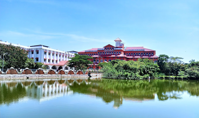
Highlights include Kannur University.
Weather in Payyanur
Forecast from MET Norway (CC BY 4.0). Full forecast
About Payyanur
Payyanur (Malayalam: [pɐjːɐnːuːr]) is a municipal town and a taluk, a sub-district administrative unit, in the Kannur district of Kerala, India. Payyanur is the first municipality in Kerala to establish libraries in all its wards. On 10 March 2018, Kerala Chief Minister Pinarayi Vijayan inaugurated Payyanur as the fifth taluk in the district. Payyanur taluk comprises 22 villages including 16 de-linked from the Taliparamba taluk and six from the Kannur taluk.
From the Wikipedia article Payyanur (this version), under CC BY-SA 4.0.
Travel tips from other travellers: Payyanur on Wikivoyage (CC BY-SA 4.0).
Things to do7
Kannur University
School · 3.9 km
State public university in Kannur, Kerala, India


Museums and landmarks3


Parks, trails and playgrounds4


Restaurants and cafes142



130 more on the map.
History
Payyanur is one of several extant ancient civilized places in Kerala. The northern town of Kerala claims a rich recorded history. The archaeological remains excavated from Payyanur and nearby places prove the existence of a city in this area centuries ago.
The earliest known mention of this town is in the Brahmanda Purana, when Garga Muni talks about this place to the Pandavas during their exile.
Several notable travelers have described this area in their writings. Ibn Battuta visited Ezhimala in AD 1342 and wrote about the large seaport and the Chinese ships anchored here. Abul Fida in AD 1273, Marco Polo in AD 1293, the Italian explorer Niccolò de' Conti in the 15th century and the Portuguese scholar and traveler Barbosa all visited this place and gave extensive accounts of Ezhimala port, which was then known as "Heli". The scholar and author Hermann Gundert and William Logan, the Malabar District Collector during the British Colonial rule, who wrote Malabar Manual, also visited Payyanur and studied the rich heritage of the area.
Centuries back, Payyanur was a part of the Ezhimala/Mushika/Kolathiri Kingdom.Book named Mushikavamsha written by Atula mention this place. King Nandan was well known as a great warrior and ruler. The books written during the Sangam period describe the area and King. Ezhimala was also under the rule of the Cheras. A famous ruler there was Pazhassi Raja.
From the History section of Payyanur on Wikipedia, under CC BY-SA 4.0.
Where to stay18
Churches and places of worship45
Subramanya Swami Temple, Payyanur
Place of worship
Subrahmanya Swami Temple Road, Payyannur
Shopping47
Gas and EV charging3
Schools, colleges and libraries29
Goverment Boys Higher Secondary School Ground and Mini Stadium, Payyanur
School · 1.8 km
Boys school ground Annur Road, Payyannur
Healthcare61
VINAYAKA
Clinic and pharmacy · 1.2 km
NEAR OLD BUSSTAND Sreeprabha Junction Road, Payyannur
DR.BALAKRISHNAN
Clinic and pharmacy · 1.4 km
VILLAGE OFFICE ROAD Sreeprabha Junction Road, Payyannur
DR.MUKUNDAN
Clinic and pharmacy · 1.1 km
NEAR VILLAGE OFFICE ROAD Sreeprabha Junction Road, Payyannur
Map of Payyanur
250 places. The map loads OpenStreetMap tiles when you open it.
Getting there and nearby towns
Kannur International Airport (CNN) is the nearest airport with scheduled flights listed in OpenStreetMap, 42 km away.
- Trikarpūr South 3 km northwest, about 3 min by car
- Kunnimangalam 5 km southeast, about 5 min by car
- Cheruthazham 7 km east, about 7 min by car
- Trikarpūr North 7 km northwest, about 7 min by car
- Mādāyi 8 km southeast, about 8 min by car
- Taliparamba 18 km east, about 18 min by car
- Kanhangad 26 km northwest, about 26 min by car
- Irikkūr 40 km east, about 40 min by car
- Tellicherry 50 km southeast, about 50 min by car
- Panoor 55 km southeast, about 55 min by car
Drive times are estimates from straight-line distance, not routes.
Local news
Headlines from INDB.
Reviews, tips and questions
Loading what members have shared...
Sources and licences
- GeoNames (CC BY 4.0): population, coordinates, regions and time zone
- OpenStreetMap contributors (ODbL 1.0): places, airports, map data
- Wikidata (CC0 1.0): elevation, founding date, time zone, website, landmarks and historic places
- Wikimedia Commons (see each image): photos
- Wikipedia (CC BY-SA 4.0): overview and history text
Photo credits
- Kannur Univerisity Thavakkara Campus, Rahul B Ashok, CC0
Page built November 3, 2026. Spotted a mistake? Tell us or suggest a place.