


Why visit Ironwood
Townapedia lists 13 museums and landmarks, 18 parks and trails, 30 places to eat, 10 places to stay and 3 attractions in and around town.
Highlights include Historic Ironwood Theatre, Mount Zion, Annala Round Barn and Chicago and Northwestern Railroad Depot.
July is the warmest month, with average highs of 77°F; January lows average 2°F, and about 186 inches of snow fall in a normal year.
Weather in Ironwood
Forecast from the National Weather Service. Full forecast
About Ironwood
Ironwood (Ojibwe: Maananoonsing) is a city in Gogebic County in the Upper Peninsula of the U.S. state of Michigan, about 18 miles (29 km) south of Lake Superior. The city is on US Highway 2 across the Montreal River from Hurley, Wisconsin. It is the westernmost city in Michigan, situated on the same line of longitude (90.2 degrees West) as Clinton, Iowa, and St. Louis, Missouri. The population was 5,045 at the 2020 census, down from 5,387 at the 2010 census.
From the Wikipedia article Ironwood, Michigan (this version), under CC BY-SA 4.0.
Things to do3



Museums and landmarks13

Annala Round Barn
Monument and historic site · National Register of Historic Places · 2.4 mi
United States historic place near Hurley, Wisconsin

Chicago and Northwestern Railroad Depot
Monument and historic site · National Register of Historic Places · 1.0 mi
Railway station in Ironwood, the United States of America
Ironwood Carnegie Library
Monument and historic site · National Register of Historic Places · 1.0 mi
Historic library in Ironwood, Michigan, United States
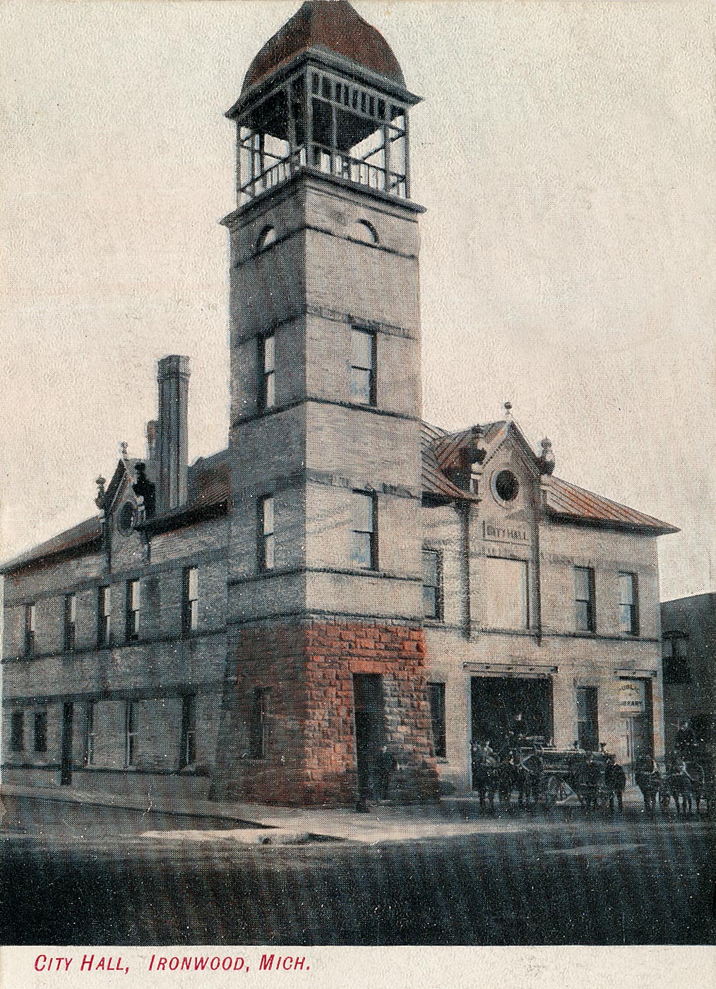
Ironwood City Hall
Monument and historic site · National Register of Historic Places · 0.8 mi
Demolished city hall in Ironwood, Michigan, United States

Ironwood Memorial/Municipal Building
Monument and historic site · National Register of Historic Places · 0.8 mi
Government building located at the corner of McLeod Avenue and Marquette Street in Ironwood, Michigan

Ironwood Theatre
Cinema and theater · National Register of Historic Places · 0.9 mi
Theater and former movie theater in Ironwood, Michigan, United States

Montreal Company Location Historic District
Monument and historic site · National Register of Historic Places · 4.2 mi
Historic district in Montreal, Wisconsin, United States

Old Iron County Courthouse
Monument and historic site · National Register of Historic Places · 1.6 mi
Hurley, Wisconsin, listed on the National Register of Historic Places in Iron County, Wisconsin
Solomon S. Curry House
Monument and historic site · National Register of Historic Places · 0.6 mi
Ironwood, Michigan, listed on the NRHP in Gogebic County, Michigan

Iron County Historical Museum
Museum · 1.6 mi
303 Iron Street, Hurley
1 more on the map.
Parks, trails and playgrounds18





6 more on the map.
Restaurants and cafes30


Rigoni's Bakery
Bakery · 0.9 mi
110 South Suffolk Street, Ironwood
Mo-Fr 07:00-17:00; Sa 07:00-16:00; Su 07:00-14:00

Joe's Pasty Shop
Diner · American · 1.0 mi
116 West Aurora Street
Don and GG's Food and Spirits
Restaurant · 0.8 mi
1300 East Cloverland Drive, Ironwood
Iron Nugget Restaurant
Restaurant · 1.7 mi
404 Silver Street, Hurley
Liberty Bell Chalet
Restaurant · Italian Pizza · 1.7 mi
109 5th Avenue South, Hurley


18 more on the map.
History
Ironwood was settled in the spring of 1885. The town was incorporated as a village in 1887 and as a city on April 8, 1889. The township area north of the city was incorporated as Ironwood Township on April 8, 1889. In 1890 the population of Ironwood passed 7,500 and in 1900 it reached 10,000. Ironwood reputedly acquired its name when Frederic W. Rhinelander, president of the Milwaukee Lake Shore and Western Railroad line, arriving by train at what was then little more than a wilderness camp, chose it to honor one of his employees, mining captain James (Iron) Wood. "Ironwood" is also a colloquial name for Ostrya virginiana, a common hardwood tree in the Upper Midwest.
Ironwood is located within the now inactive Gogebic Iron Range. Iron ore was found in the area in the 1870s. The arrival of the railroad in the mid-1880s gave an impetus to more extensive development of the area's ore deposits. Several mines, such as the Norrie, Aurora, Ashland, Newport, and Pabst, were opened in Ironwood. The mines and the lumber works attracted newcomers from other parts of the US and from European countries such as England, Finland, Germany, Italy, Poland, and Sweden.
From the History section of Ironwood, Michigan on Wikipedia, under CC BY-SA 4.0.
Where to stay10
AmericInn by Wyndham Ironwood
Motel and hotel · 0.7 mi
1117 East Cloverland Drive, Ironwood
Churches and places of worship17
Jehovahs Witness Kingdom Hall
Church · Jehovahs Witness · 1.7 mi
1112 Superior Street, Ironwood
Shopping10
Gas and EV charging7
Schools, colleges and libraries13
Healthcare1
Map of Ironwood
122 places. The map loads OpenStreetMap tiles when you open it.
Climate by month
Monthly table
| Month | High | Low | Rain | Snow |
|---|---|---|---|---|
| Jan | 20°F | 2°F | 2.0 in | 43.1 in |
| Feb | 26°F | 4°F | 1.5 in | 30.9 in |
| Mar | 37°F | 14°F | 2.0 in | 23.9 in |
| Apr | 49°F | 27°F | 3.1 in | 11.7 in |
| May | 64°F | 40°F | 3.8 in | 1.9 in |
| Jun | 73°F | 50°F | 3.9 in | 0.0 in |
| Jul | 77°F | 55°F | 4.2 in | 0.0 in |
| Aug | 76°F | 52°F | 3.8 in | 0.0 in |
| Sep | 68°F | 46°F | 3.8 in | 0.3 in |
| Oct | 53°F | 34°F | 4.0 in | 6.0 in |
| Nov | 38°F | 23°F | 2.9 in | 24.1 in |
| Dec | 26°F | 11°F | 2.4 in | 43.6 in |
U.S. Climate Normals 1991-2020 for Ironwood #2 (1 mi away), rain and snow from Ironwood Hcn, NOAA NCEI.
People and cost of living
American Community Survey 5-year estimates, 2020-2024, U.S. Census Bureau. Estimates have margins of error, larger for small towns.
Disaster history
Gogebic County has had 6 federal disaster declarations since 2000, most often for floods.
- 2020-03-27: Covid-19 Pandemic (Biological)
- 2020-03-13: Covid-19 (Biological)
- 2018-08-02: Severe Storms, Flooding, Landslides, And Mudslides (Flood)
- 2013-06-18: Flooding (Flood)
- 2005-09-07: Hurricane Katrina Evacuation (Hurricane)
- 2002-05-06: Flooding (Flood)
OpenFEMA disaster declarations summaries.
Getting there and nearby towns
Gogebic–Iron County Airport (IWD) is the nearest airport with scheduled flights listed in OpenStreetMap, 5 miles away.
- Hurley 3 mi west, about 5 min by car
- Bessemer 5 mi east, about 8 min by car
- Montreal 5 mi west, about 7 min by car
- Ramsay 7 mi east, about 12 min by car
- Wakefield 10 mi east, about 17 min by car
- Birch Hill 20 mi west, about 32 min by car
- Mercer 21 mi south, about 33 min by car
- Mellen 26 mi west, about 42 min by car
- Ashland 35 mi west, about 57 min by car
- Ontonagon 49 mi northeast, about 1 h 15 min by car
Drive times are estimates from straight-line distance, not routes.
Local news
Headlines from INDB, the NEMICO news database.
Reviews, tips and questions
Loading what members have shared...
Sources and licences
- NCES EDGE (Public domain): public schools
- NOAA NCEI U.S. Climate Normals 1991-2020 (Public domain): climate by month
- OpenFEMA (Public domain): disaster declarations
- OpenStreetMap contributors (ODbL 1.0): places, airports, map data
- U.S. Census Bureau (Public domain): population, income, housing, education, commute
- Wikidata (CC0 1.0): elevation, founding date, time zone, website, landmarks and historic places
- Wikimedia Commons (see each image): photos
- Wikipedia (CC BY-SA 4.0): overview and history text
Photo credits
- 2009-0617-downtown-Ironwood, Bobak Ha'Eri, CC BY 3.0
- 2013-07-13 Solomon S. Curry House, 634 McLeod Ave, Ironwood, MI, side view, Sa magnuson33, CC BY-SA 3.0
- 2013-07-13 Solomon S. Curry House, 632 McLeod Ave, Ironwood, MI, side view, Sa magnuson33, CC BY-SA 3.0
- 2013-07-13 Solomon S. Curry House, 633 McLeod Ave, Ironwood, MI, side view, Sa magnuson33, CC BY-SA 3.0
- 2013-07-13 Solomon S. Curry House, 631 McLeod Ave, Ironwood, MI, side view, Sa magnuson33, CC BY-SA 3.0
- 2013-07-13 Solomon S. Curry House, 635 McLeod Ave, Ironwood, MI, side view, Sa magnuson33, Public domain
- Greetings from Ironwood, Michigan - Large Letter Postcard (8333610852), Steve Shook from Moscow, Idaho, USA, CC BY 2.0
- Ironwood Memorial Municipal Building Side View on McLeod, Royalbroil, CC BY-SA 3.0
- Greetings from Ironwood, Michigan - Large Letter Postcard (14324548053), Steve Shook from Moscow, Idaho, USA, CC BY 2.0
- Downtown Ironwood - panoramio, Ian Shackleford, CC BY 3.0
- Cold Iron Brewing - Ironwood, Michigan (49044966177), Tony Webster from Minneapolis, Minnesota, United States, CC BY 2.0
- 2013-07-13 Ironwood Carnegie Library, 235 E. Aurora St., Ironwood, MI, Sa magnuson33, CC BY-SA 3.0
- 2009-0617-MemorialBuilding-Ironwood, Bobak Ha'Eri, CC BY 3.0
- 2009-0617-ChicagoNorthwesternDepot -Ironwood, Bobak Ha'Eri, CC BY 3.0
- 2009-0617-OldIronCtyCourthouse-Hurley, Bobak Ha'Eri, CC BY 3.0
- 2009-0617-IronwoodTheatreComplex-Ironwood, Bobak Ha'Eri, CC BY 3.0
- Montreal Company Historic District Larger House Style August 2012, Royalbroil, CC BY-SA 3.0
- Ironwood-city-hall-1905, Unknown author Unknown author, Public domain
- Hiawatha - panoramio, Ian Shackleford, CC BY 3.0
- Pabst Pond - panoramio, Ian Shackleford, CC BY 3.0
- Ashland Iron Mine Pond - panoramio, Ian Shackleford, CC BY 3.0
- Norrie Park - panoramio, Ian Shackleford, CC BY 3.0
- Krist Gas Station - Hurley - Wisconsin, Tony Webster, CC BY-SA 2.0
- Xcel Power Lines - panoramio (1), Corey Coyle, CC BY 3.0
- Gogebic Community College - panoramio, Ian Shackleford, CC BY 3.0
- The Jewish Community of the Gogebic Range, Jrryjude, CC0
- Old Iron County Courthouse - panoramio, Corey Coyle, CC BY 3.0
- Leon Lewis Historical Marker, Jrryjude, CC0
- St Mary of the Seven Dolors Catholic Church - panoramio, Corey Coyle, CC BY 3.0
- DQ Grill ^ Chill® - panoramio (2), Corey Coyle, CC BY 3.0
- Days Inn® Hurley - panoramio, Corey Coyle, CC BY 3.0
- Michigan welcome, Andreas Faessler, CC BY-SA 4.0
- Montreal River - panoramio, Ian Shackleford, CC BY 3.0
- Hurley Inn Formerly Ramada - panoramio, Corey Coyle, CC BY 3.0
- Wisconsin Welcome Center - panoramio, Corey Coyle, CC BY 3.0
- Erwin Central School, rossograph, CC BY-SA 4.0
- Annala Round Barn, Hurley, Wisconsin (8332719467), Royal Broil from East Central, Wisconsin, USA, CC BY-SA 2.0
- Annala Round Barn Buildings Hurley Iron County Wisconsin, Royalbroil, CC BY-SA 3.0
- Fall Foliage near Hurley - panoramio, Corey Coyle, CC BY 3.0


Page built October 30, 2026. Spotted a mistake? Tell us or suggest a place.