
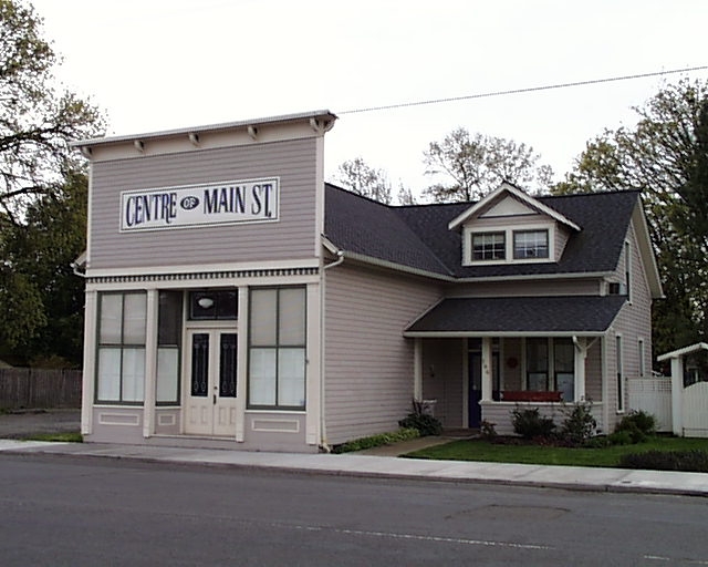


Jefferson, Oregon
Jefferson is a city of 3,301 people in Marion County, Oregon, founded in 1870.
Why visit Jefferson
Townapedia lists 1 park or trail in and around town.
Weather in Jefferson
Forecast from the National Weather Service. Full forecast
About Jefferson
Jefferson is a city in Marion County, Oregon, United States. It is part of the Salem Metropolitan Statistical Area. The population was 3,327 at the 2020 census. The city sits on the east (right) bank of the Santiam River between Salem and Albany along Oregon Route 164 east of Interstate 5.
From the Wikipedia article Jefferson, Oregon (this version), under CC BY-SA 4.0.
Parks, trails and playgrounds1

Churches and places of worship3


Jefferson Methodist Church
Church · National Register of Historic Places
Church building in Oregon, United States of America

Saint Thomas Catholic Church
Church · Roman Catholic · 0.5 mi
Mission of St. Bernard; Mailing: PO Box 928, Jefferson, OR, 97352
647 North 3rd Street, Jefferson
Schools, colleges and libraries7


History
The first name for this locality was Conser's Ferry, for Jacob S. Conser, an Oregon Trail pioneer of 1848 who ran a ferry across the Santiam River. Conser was also involved in the communities of Syracuse and Santiam City, which were about 2 miles (3 km) downstream of Jefferson. He established the ferry in 1851, and also served as the postmaster of Santiam City. When the Jefferson Institute was established in the vicinity (not the same as the Jefferson Institute in Polk County), the name Jefferson was eventually adopted by the community. Jefferson post office was established in 1861, with a name change from Syracuse, and previously, Santiam City.
In 1974, the Jacob Conser House was listed on the National Register of Historic Places (NRHP), which served as the city's library until 2018. The current Oregon Route 164 bridge across the Santiam was designed by Conde McCullough and named in Conser's honor. The Jefferson Methodist Church was added to the NRHP in 1980. In 2017, voters recalled mayor Cyndie Hightower, and three city council members resigned over issues related to the annexation of land into the city.
From the History section of Jefferson, Oregon on Wikipedia, under CC BY-SA 4.0.
Map of Jefferson
11 places. The map loads OpenStreetMap tiles when you open it.
People and cost of living
American Community Survey 5-year estimates, 2020-2024, U.S. Census Bureau. Estimates have margins of error, larger for small towns.
Disaster history
Marion County has had 11 federal disaster declarations since 2000, most often for fires.
- 2023-08-24: Liberty Fire (Fire)
- 2021-05-04: Severe Winter Storm (Severe Storm)
- 2020-09-15: Wildfires And Straight-Line Winds (Fire)
- 2020-09-10: Wildfires (Fire)
- 2020-09-08: Beachie Creek Lionshead Fire Complex (Fire)
- 2020-03-28: Covid-19 Pandemic (Biological)
OpenFEMA disaster declarations summaries.
Getting there and nearby towns
Salem - Willamette Valley Airport (SLE) is the nearest airport with scheduled flights listed in OpenStreetMap, 13 miles away.
- Albany 8 mi southwest, about 12 min by car
- Aumsville 11 mi northeast, about 18 min by car
- Adair Village 11 mi west, about 17 min by car
- Tangent 13 mi southwest, about 21 min by car
- Salem 14 mi north, about 23 min by car
- Lebanon 14 mi south, about 22 min by car
- Independence 14 mi northwest, about 22 min by car
- Monmouth 14 mi northwest, about 23 min by car
- Four Corners 15 mi north, about 24 min by car
- Corvallis 17 mi southwest, about 27 min by car
Drive times are estimates from straight-line distance, not routes.
Local news
Headlines from INDB, the NEMICO news database.
Reviews, tips and questions
Loading what members have shared...
Sources and licences
- NCES EDGE (Public domain): public schools
- OpenFEMA (Public domain): disaster declarations
- OpenStreetMap contributors (ODbL 1.0): places, airports, map data
- U.S. Census Bureau (Public domain): population, income, housing, education, commute
- Wikidata (CC0 1.0): elevation, founding date, time zone, website, landmarks and historic places
- Wikimedia Commons (see each image): photos
- Wikipedia (CC BY-SA 4.0): overview and history text
Photo credits
- Jefferson Oregon NRHP Store, Katr67, Public domain
- Jefferson City Hall, Jefferson - DPLA - 8e32ad08bbd0021c3b328b8891b054f4, Gary Halvorson, Oregon State Archives, CC BY 4.0
- Jefferson City Hall, Jefferson - DPLA - 268747989716b7094800093e9acb6f7e, Gary Halvorson, Oregon State Archives, CC BY 4.0
- Conser House - Jefferson Oregon, Ian Poellet, CC BY-SA 3.0
- 2012 0908 JEFFERSON, Joangray, mehamaOR, CC BY-SA 3.0
- ISS047-E-106100 - View of Earth, Earth Science and Remote Sensing Unit , Lyndon B. Johnson Space Center, Public domain
- ISS056-E-65582 - View of Earth, Earth Science and Remote Sensing Unit, NASA Johnson Space Center, Public domain
- ISS027-E-27404 - View of Earth, Earth Science and Remote Sensing Unit , Lyndon B. Johnson Space Center, Public domain
- ISS056-E-65580 - View of Earth, Earth Science and Remote Sensing Unit, NASA Johnson Space Center, Public domain
- ISS048-E-25339 - View of Oregon, Earth Science and Remote Sensing Unit , Lyndon B. Johnson Space Center, Public domain
- ISS056-E-65581 - View of Earth, Earth Science and Remote Sensing Unit, NASA Johnson Space Center, Public domain
- ISS056-E-65583 - View of Earth, Earth Science and Remote Sensing Unit, NASA Johnson Space Center, Public domain


Page built October 30, 2026. Spotted a mistake? Tell us or suggest a place.