

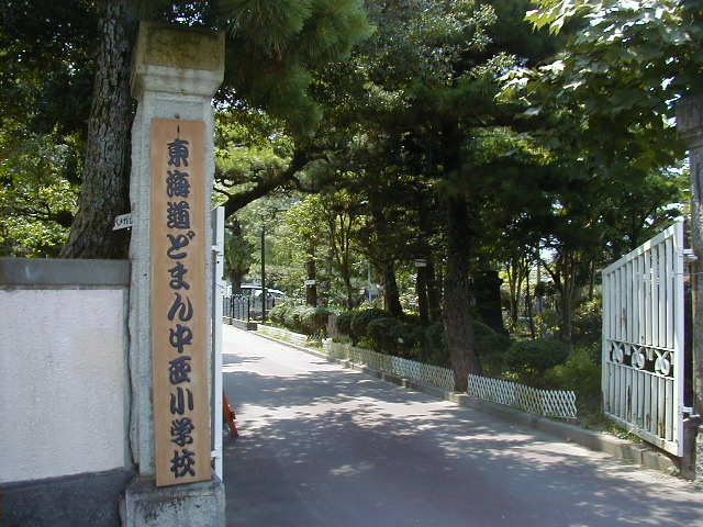


Fukuroi, Japan
袋井市
Fukuroi is a town of 88,395 people in Shizuoka, Japan, founded in April 1, 1889.
Why visit Fukuroi
Townapedia lists 20 museums and landmarks, 116 parks and trails, 75 places to eat, 5 places to stay and 12 attractions in and around town.
Highlights include Shizuoka Institute of Science and Technology, Mikuriya Kofun Group, 大門大塚古墳 and Shizuoka Stadium ECOPA.
Weather in Fukuroi
Forecast from MET Norway (CC BY 4.0). Full forecast
About Fukuroi
Fukuroi (袋井市, Fukuroi-shi) is a city located in Shizuoka Prefecture, Japan. As of 1 July 2019, the city had an estimated population of 88,395 in 34,842 households, and a population density of 820 persons per km2. The total area of the city was 108.33 square kilometres (41.83 sq mi). Fukuroi is a member of the World Health Organization’s Alliance for Healthy Cities (AFHC).
From the Wikipedia article Fukuroi, Shizuoka (this version), under CC BY-SA 4.0.
Travel tips from other travellers: Fukuroi on Wikivoyage (CC BY-SA 4.0).
Things to do12



Museums and landmarks20

Mikuriya Kofun Group
Monument and historic site · 4.3 km
Group of kofun burial mounds in Japan



Naguri Tōkaidō Matsunamiki (pine tree allée)
Monument and historic site · 3.9 km

8 more on the map.
Parks, trails and playgrounds116




104 more on the map.
Restaurants and cafes75


とんかつ せんば
Restaurant · とんかつ · 1.0 km
11:00-14:30,17:00-21:00; We off
ビーワンカフェ.
Cafe · Burger, パン, Coffee Shop · 4.4 km
Mo-Tu,Th-Su 09:00-19:00; We off
青木軒
Restaurant · Ramen · 4.2 km
Mo,Su off; Tu-Fr 09:00-14:00,17:00-20:30; Sa 07:00-14:00
63 more on the map.
History
During the Sengoku period, Fukuroi was part of the domain within Tōtōmi Province governed by Yamauchi Kazutoyo from Kakegawa Castle. During the Edo period, the area was tenryō territory under direct control of the Tokugawa shogunate. The settlement prospered as Fukuroi-juku on the Tōkaidō highway connecting Edo with Kyoto. After the Meiji Restoration, in with the 1889 establishment of the modern municipalities system, Fukuroi-juku became the town of Yamana within Yamana District, Shizuoka Prefecture. Yamana District was merged into Iwata District in 1896, and the town's name was changed back to Fukuroi in 1909. Fukuroi merged with the neighboring village of Kasai in 1928. It continued to grow in the 1950s, annexing neighboring villages of Kudonishi (from Shuchi District) in 1948, Kudo in 1952, Imai in 1954, Mikawa in 1955, Tahara in 1956, as well as the village of Kasahara from Ogasa District, also in 1956. On November 3, 1958, Fukuroi was elevated to city status. It further expanded through annexation of the town of Yamanashi from Shuchi District in 1963.
During the 2002 FIFA World Cup, as location of (Shizuoka Stadium), Fukuroi played host of some of the events.
On April 1, 2005, the town of Asaba (from Iwata District) was merged into Fukuroi.
From the History section of Fukuroi, Shizuoka on Wikipedia, under CC BY-SA 4.0.
Where to stay5
Churches and places of worship212
Shopping22
Gas and EV charging28
Schools, colleges and libraries45
Healthcare33
Mitsuke Policlínica de Iwata
Clinic and pharmacy · 6.3 km
395-1 Mizuhori, Iwata, Shizuoka 438-0085
Map of Fukuroi
250 places. The map loads OpenStreetMap tiles when you open it.
Getting there and nearby towns
Shizuoka Airport (FSZ) is the nearest airport with scheduled flights listed in OpenStreetMap, 25 km away.
- Iwata 8 km southwest, about 8 min by car
- Kakegawa 9 km east, about 9 min by car
- Mori 9 km north, about 9 min by car
- Hamakita 13 km northwest, about 13 min by car
- Hamamatsu 18 km west, about 18 min by car
- Kanaya 21 km east, about 21 min by car
- Shimada 25 km east, about 25 min by car
- Sagara 27 km east, about 27 min by car
- Fujieda 34 km east, about 34 min by car
- Yaizu 39 km east, about 39 min by car
Drive times are estimates from straight-line distance, not routes.
Local news
Headlines from INDB.
Reviews, tips and questions
Loading what members have shared...
Sources and licences
- GeoNames (CC BY 4.0): population, coordinates, regions and time zone
- OpenStreetMap contributors (ODbL 1.0): places, airports, map data
- Wikidata (CC0 1.0): elevation, founding date, time zone, website, landmarks and historic places
- Wikimedia Commons (see each image): photos
- Wikipedia (CC BY-SA 4.0): overview and history text
Photo credits
- Fukuroi city hall, アラツク, CC BY-SA 4.0
- Fukuroi - panoramio, abu_9495, CC BY 3.0
- Muramatsu, Fukuroi, Shizuoka Prefecture 437-0011, Japan - panoramio (5), Sato S, CC BY-SA 3.0
- Muramatsu, Fukuroi, Shizuoka Prefecture 437-0011, Japan - panoramio (6), Sato S, CC BY-SA 3.0
- Fukuroi Banner, Sato S, CC BY-SA 3.0
- Muramatsu, Fukuroi, Shizuoka Prefecture 437-0011, Japan - panoramio (2), Sato S, CC BY-SA 3.0
- Ecopa030304, WAKA77, Public domain
- Yamahastafium05161, WAKA77, Public domain
- Rōmon of Fuhachimangū, 立花左近, CC BY-SA 3.0
- Hattasan Hondō, Yanajin33, CC BY-SA 3.0
- Iwata City Hospital, Waka77, CC0
- Shizuoka Prefectural Fukuroi Commercial HS, Nyao148, CC BY-SA 4.0
- Totomi Kokubunji 2018-04 kondo, photo: Qurren ( talk ) Taken with Canon PowerShot G9 X, CC BY-SA 4.0
- Yanahime Jinja Haiden, Zeter114514, CC BY-SA 4.0
- Takabe Sekishitsu cropped Totomi Koseki Zue Frame 32, 国立国会図書館, Public domain
- SIST, Osyuu at Japanese Wikipedia, CC BY-SA 3.0
- Shorinzan Kofun, funkyu, Saigen Jiro, CC0
- ヤマハスタジアム1, ムイチモン, CC0
- Fuhachimangu (Iwata), romon, Saigen Jiro, CC0
- 今川貞世(了俊)供養塔(袋井市), C2revenge, CC0
- 海蔵寺山門(袋井市), C2revenge, CC0
- 静岡県袋井市徳光 - panoramio, gundam2345, CC BY 3.0
- 可睡ゆりの園駐車場の桜 - panoramio (1), Sato S, CC BY-SA 3.0
- 可睡ゆりの園駐車場の桜 - panoramio, Sato S, CC BY-SA 3.0
- 可睡ゆりの園 KASUI-Lily's Park - panoramio, Seko Naotomo, CC BY 3.0
- Iwata Mikano - panoramio (1), Pequenas Cousas, CC BY 3.0
- Iwata Mikano - panoramio, Pequenas Cousas, CC BY 3.0
- Iwata Mikano - panoramio (2), Pequenas Cousas, CC BY 3.0
- Tengu-Kasuisai, Yanajin33, CC BY-SA 3.0
- Karasu-Tengu-Kasuisai, Yanajin33, CC BY-SA 3.0
- Japan National Route 1 -25, Aimaimyi, CC BY-SA 3.0
- Okegayanuma November from Hut-C, Motamota, CC BY-SA 4.0
- Okegayanuma November from Hut-B, Motamota, CC BY-SA 4.0
- 千鳥ヶ池 - panoramio, Sato S, CC BY-SA 3.0
- 千鳥ヶ池の浮橋 - panoramio, Sato S, CC BY-SA 3.0
- 千鳥ヶ池 - panoramio (1), Sato S, CC BY-SA 3.0
- 千鳥ヶ池 - panoramio (2), Sato S, CC BY-SA 3.0
- Iwata Shizuoka 2022 Dec 30 07-34AM, Nesnad, CC BY 4.0
- 平清盛・平重盛供養塔(磐田市), C2revenge, CC0
- Shizuoka Stadium from air 2023 Jan 06 02-30PM, Nesnad, CC BY 4.0


Page built November 5, 2026. Spotted a mistake? Tell us or suggest a place.