


Shimonoseki, Japan
下関市
Shimonoseki is a town of 265,684 people in Yamaguchi, Japan, founded in April 1, 1889.
Why visit Shimonoseki
Townapedia lists 110 museums and landmarks, 111 parks and trails, 122 places to eat, 24 places to stay and 37 attractions in and around town.
Highlights include Baiko Gakuin University, Hesaki Lighthouse, 下関市立近代先人顕彰館(田中絹代ぶんか館) and Akama Shrine Treasure Hall.
Weather in Shimonoseki
Forecast from MET Norway (CC BY 4.0). Full forecast
About Shimonoseki
Shimonoseki (Japanese: 下関市, Hepburn: Shimonoseki-shi) is a city located in Yamaguchi Prefecture, Japan. The city used to be referred to as Bakan (馬関). As of 30 June 2023, the city had an estimated population of 248,193 in 128,762 households and a population density of 350 persons per km2. The total area of the city is 716.18 square kilometres (276.52 sq mi).
From the Wikipedia article Shimonoseki (this version), under CC BY-SA 4.0.
Travel tips from other travellers: Shimonoseki on Wikivoyage (CC BY-SA 4.0).
Things to do37
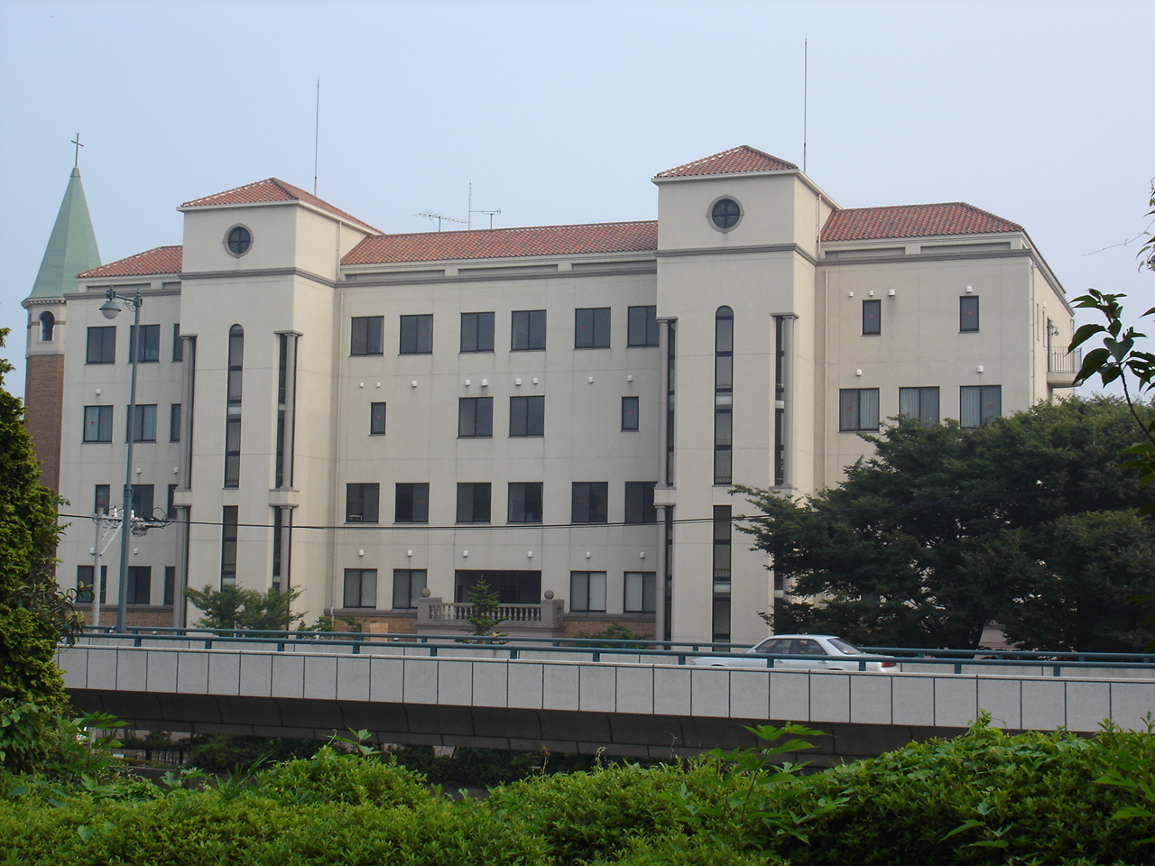
Baiko Gakuin University
School · 1.4 km
Higher education institution in Yamaguchi Prefecture, Japan


Kanmon Bridge
Bridge · 2.1 km
Suspension bridge that crosses the Strait Kanmon Strait and unites the islands of Honshū and Kyūshū of Japan.

Kyushu Dental University
School · 12.0 km
Higher education institution in Fukuoka Prefecture, Japan

Kyushu Institute of Technology
School · 11.3 km
Higher education institution in Fukuoka Prefecture, Japan

Kyushu International University
School · 16.9 km
Higher education institution in Fukuoka Prefecture, Japan

Kyushu Nutrition Welfare University
School · 11.4 km
Higher education institution in Fukuoka Prefecture, Japan


Shimonoseki City University
School · 3.6 km
Higher education institution in Yamaguchi Prefecture, Japan


Space World
Monument and historic site · 14.7 km
Former amusement park in Japan
25 more on the map.
Museums and landmarks110



Ayaragigō Site
Monument and historic site · 6.5 km
Archaeological site in Japan

Chōshū Domain Shimonoseki Maeda Battery
Monument and historic site · 3.7 km
Fortification in Yamaguchi, Japan


Kajikurihama Site
Monument and historic site · 6.9 km
Archaeological site in Shimonoseki, Yamaguchi, Japan


Kitakyushu Museum of Natural History & Human History
Museum · 15.3 km
Museum in Kitakyūshū, Fukuoka, Japan


Shimonoseki City Archaeological Museum
Museum · 6.3 km
Museum in Shimonoseki, Yamaguchi, Japan

Shimonoseki City Art Museum
Museum · 6.2 km
Art museum in Shimonoseki, Yamaguchi, Japan

Shimonoseki City Museum of History
Museum · 6.2 km
Museum in Shimonoseki, Yamaguchi, Japan
98 more on the map.
Parks, trails and playgrounds111





99 more on the map.
Restaurants and cafes122






110 more on the map.
History
Shimonoseki is part of ancient Nagato Province. It has prospered since ancient times as the gateway to Honshu island from the Asian continent, including Kyushu, China, and the Korean Peninsula. According to the Nihon Shoki, the semi-legendary Emperor Chuai constructed a palace at the location of what is now the Shimonoseki city hall during the Kofun period. The name of "Shimonoseki" appears in Heian period documents from 869 AD as the location of a checkpoint controlling maritime access to the Seto Inland Sea; however, by the Kamakura period, the name of "Akamanoseki" was in more common use. During the Genpei War, the Heike and Genji fought at the Battle of Dan-no-ura near the present Kanmon Bridge.
Akamagaseki city was established on April 1, 1889 with the creation of the modern municipalities system. The city was renamed Shimonoseki on June 1, 1902.
On February 13, 2005, Shimonoseki absorbed the towns of Hōhoku, Kikugawa, Toyota and Toyoura (all from Toyoura District) to create the new and expanded city of Shimonseki. Since October 1, 2005, the city has been designated as a core city by the Japanese government with increased local autonomy.
From the History section of Shimonoseki on Wikipedia, under CC BY-SA 4.0.
Where to stay24
Churches and places of worship29
Shopping30
Gas and EV charging4
Schools, colleges and libraries60
Healthcare27
Map of Shimonoseki
250 places. The map loads OpenStreetMap tiles when you open it.
Getting there and nearby towns
Kitakyushu Airport (KKJ) is the nearest airport with scheduled flights listed in OpenStreetMap, 16 km away.
- Kitakyushu 14 km southwest, about 14 min by car
- Ube 29 km east, about 29 min by car
- Iizuka 42 km southwest, about 42 min by car
- Yamaguchi 55 km northeast, about 55 min by car
- Fukuoka 62 km southwest, about 1 h by car
- Ōnojō 63 km southwest, about 1 h by car
- Chikushino-shi 64 km southwest, about 1 h by car
- Kasuga 65 km southwest, about 1 h by car
- Kurume 81 km southwest, about 1 h 15 min by car
- Tokuyama 82 km east, about 1 h 15 min by car
Drive times are estimates from straight-line distance, not routes.
Local news
Headlines from INDB.
Reviews, tips and questions
Loading what members have shared...
Sources and licences
- GeoNames (CC BY 4.0): population, coordinates, regions and time zone
- OpenStreetMap contributors (ODbL 1.0): places, airports, map data
- Wikidata (CC0 1.0): elevation, founding date, time zone, website, landmarks and historic places
- Wikimedia Commons (see each image): photos
- Wikipedia (CC BY-SA 4.0): overview and history text
Photo credits
- Route9 Ends Shimonoseki stn, ja:User:Sanjo, CC BY-SA 3.0
- London bus in Shimonoseki, Yamaguchi, そらみみ, CC BY-SA 4.0
- Shimonoseki Aquarium 20170811-3, そらみみ, CC BY-SA 4.0
- Shimonoseki Aquarium 20170811-2, そらみみ, CC BY-SA 4.0
- Special Reserve of Humboldt penguin in Shimonoseki Aquarium KAIKYOKAN, 要塞騎士, CC BY-SA 4.0
- Anchors on Anchor Square of Shimonoseki Port, そらみみ, CC BY-SA 4.0
- 141122 Shimonoseki Nabe-cho Post Office Shimonoseki Yamaguchi pref Japan11s, 663highland, CC BY 2.5
- 141122 Shimonoseki Nabe-cho Post Office Shimonoseki Yamaguchi pref Japan03n, 663highland, CC BY 2.5
- 141122 Shimonoseki Nabe-cho Post Office Shimonoseki Yamaguchi pref Japan08s3, 663highland, CC BY 2.5
- 141122 Shimonoseki Nabe-cho Post Office Shimonoseki Yamaguchi pref Japan12s, 663highland, CC BY 2.5
- 141122 Shimonoseki Nabe-cho Post Office Shimonoseki Yamaguchi pref Japan10s3, 663highland, CC BY 2.5
- 141122 Shimonoseki Nabe-cho Post Office Shimonoseki Yamaguchi pref Japan06s3, 663highland, CC BY 2.5
- 141122 Shimonoseki Nabe-cho Post Office Shimonoseki Yamaguchi pref Japan09s3, 663highland, CC BY 2.5
- 141122 Shimonoseki Nabe-cho Post Office Shimonoseki Yamaguchi pref Japan14s, 663highland, CC BY 2.5
- 141122 Shimonoseki Nabe-cho Post Office Shimonoseki Yamaguchi pref Japan02s5, 663highland, CC BY 2.5
- 141122 Shimonoseki Nabe-cho Post Office Shimonoseki Yamaguchi pref Japan04n, 663highland, CC BY 2.5
- 141122 Shimonoseki Nabe-cho Post Office Shimonoseki Yamaguchi pref Japan05s3, 663highland, CC BY 2.5
- 141122 Shimonoseki Nabe-cho Post Office Shimonoseki Yamaguchi pref Japan07s5, 663highland, CC BY 2.5
- 141122 Shimonoseki Nabe-cho Post Office Shimonoseki Yamaguchi pref Japan01bs5, 663highland, CC BY 2.5
- 141122 Shimonoseki Nabe-cho Post Office Shimonoseki Yamaguchi pref Japan13s, 663highland, CC BY 2.5
- Hesaki Light, Morumoru, CC BY-SA 3.0
- Kyushu dental college, Kugel, Public domain
- Kit front gate, No machine-readable author provided. Historian~commonswiki assumed (based on copyright claims)., CC BY 2.5
- Kyushu Nutrition Welfare University, Kugel, Public domain
- Mutsure Shima Light, Morumoru, CC BY-SA 3.0
- Shirasu toudai, Takayuki, Public domain
- Space World 01, ja:User:Sanjo, CC BY-SA 3.0
- 綾羅木郷遺跡墳丘墓, 小池 隆, CC BY 3.0
- Choshu-Battery-Capture-Shimonoseki-1864, Felice Beato, Public domain
- Kajikurihama iseki monument, MChew, CC BY-SA 4.0
- Kitakyushu Municipal Museum of Art 20090728, ja:利用者:Wiki591801, CC BY 3.0
- Kitakyusyu museum of natural history and human history, Kugel, CC BY-SA 3.0
- 下関市立考古博物館, 小池 隆, CC BY 3.0
- Shimonoseki Municipal Art Museum, Bio06940, CC BY-SA 4.0
- Shimonoseki Municipal Shimonoseki History Museum, Bio06940, CC BY-SA 4.0
- Shimonoseki City Univ, Wiki708 at Japanese Wikipedia, CC BY-SA 3.0
- Mekari-jinja 07, Hide-sp, CC BY-SA 3.0
- Akama jingu maingate, 설총, CC BY-SA 3.0
- Hiraodai, Si-take. at Japanese Wikipedia, CC BY-SA 3.0
- Dairen-jinja, nnh, Public domain
- Yamaguchi international synthesis center 20130721, 新幹線, CC BY-SA 4.0
- Shimonoseki Jr Coll HS, Wiki708 at Japanese Wikipedia, CC BY-SA 3.0
- View of Shumpanro Hotel, Shimonoseki, Yamaguchi, そらみみ, CC BY-SA 4.0
- シーモール下関正面全景(2023年9月), なしはな, CC BY-SA 4.0
- 141122 Kameyama hachimangu Shimonoseki Yamaguchi pref Japan02n, 663highland, CC BY 2.5
- Moji hospital,Kitakyushu, Kugel, Public domain
- Shimonoseki Ootoshijinjya, usiwakamaru, Public domain
- 引接寺三門 - panoramio - bettara, bettara, CC BY-SA 3.0
- View from roof of Hinoyama Station (northeast), そらみみ, CC BY-SA 4.0
- Sukesan udon Norisada branch, Asteroid F, CC BY-SA 4.0
- Haikarat yokocho, TT mk2, CC BY-SA 4.0
- 141122 Former British Consulate Shimonoseki Yamaguchi pref Japan01bs5, 663highland, CC BY 2.5
- Pagoda 90px, Mi piace angeli, CC BY-SA 3.0
- Museum of Treaty of Shimonoseki in Shumpanro Hotel, そらみみ (Soramimi), CC BY-SA 4.0
- 141122 Tanaka Kinuyo Cultural Museum Shimonoseki Yamaguchi pref Japan01s3, 663highland, CC BY-SA 4.0
- Baiko gakuin Univ, Wiki708 at Japanese Wikipedia, CC BY-SA 3.0
- Shimonoseki Commercial HS, Wiki708, CC BY-SA 3.0
- Pine trees in Mimosusogawa Park, そらみみ, CC BY-SA 4.0
- Hikottoland marine beach, Amy00, CC BY-SA 3.0
- Kammon Strait and Mount Hinoyama near Cape Moji Lighthouse 1, そらみみ, CC BY-SA 4.0


Page built November 4, 2026. Spotted a mistake? Tell us or suggest a place.