
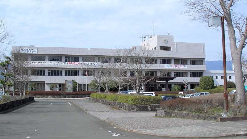


Taragi, Japan
多良木町
Taragi is a town of 9,076 people in Kumamoto, Japan, founded in April 1, 1889.
Why visit Taragi
Townapedia lists 6 museums and landmarks, 12 parks and trails, 6 places to eat, 6 places to stay and 3 attractions in and around town.
Highlights include 湯前まんが美術館.
Weather in Taragi
Forecast from MET Norway (CC BY 4.0). Full forecast
About Taragi
Taragi (多良木町, Taragi-machi) is a town located in Kuma District, Kumamoto Prefecture, Japan.As of 31 August 2024, the town had an estimated population of 8,200 in 3212 households, and a population density of 49 persons per km2. The total area of the town is 165.86 km2 (64.04 sq mi).
From the Wikipedia article Taragi, Kumamoto (this version), under CC BY-SA 4.0.
Things to do3


Museums and landmarks6



Parks, trails and playgrounds12


Restaurants and cafes6


History
The area of Taragi was part of ancient Higo Province, During the Edo Period it was part of the holdings of Hitoyoshi Domain. After the Meiji restoration, the village of Taragi was established with the creation of the modern municipalities system on April 1, 1889. It was raised to town status on May 1, 1926.
From the History section of Taragi, Kumamoto on Wikipedia, under CC BY-SA 4.0.
Where to stay6
Churches and places of worship20
Shopping3
Gas and EV charging2
Schools, colleges and libraries29
Healthcare7
Map of Taragi
94 places. The map loads OpenStreetMap tiles when you open it.
Getting there and nearby towns
Kagoshima Airport (KOJ) is the nearest airport with scheduled flights listed in OpenStreetMap, 55 km away.
- Ebino 26 km south, about 26 min by car
- Kobayashi 32 km south, about 32 min by car
- Tsunagi 43 km west, about 43 min by car
- Uki 47 km northwest, about 47 min by car
- Matsubase 49 km northwest, about 49 min by car
- Minamata 50 km west, about 50 min by car
- Mifune 51 km north, about 51 min by car
- Uto 53 km northwest, about 53 min by car
- Miyakonojō 61 km south, about 1 h by car
- Kumamoto 64 km north, about 1 h by car
Drive times are estimates from straight-line distance, not routes.
Local news
Headlines from INDB.
Reviews, tips and questions
Loading what members have shared...
Sources and licences
- GeoNames (CC BY 4.0): population, coordinates, regions and time zone
- OpenStreetMap contributors (ODbL 1.0): places, airports, map data
- Wikidata (CC0 1.0): elevation, founding date, time zone, website
- Wikimedia Commons (see each image): photos
- Wikipedia (CC BY-SA 4.0): overview and history text
Photo credits
- Tragi town hall building 1, MK Products at Japanese Wikipedia, CC BY-SA 3.0
- Kumamoto Prefectural road Route185 Taragi 1, MK Products, CC BY-SA 3.0
- くま川鉄道・東多良木駅 Higashi Taragi Station of Kumagawa Tetsudou - panoramio, shunsaku hara (r265), CC BY-SA 3.0
- Kumagawa cycling road higashi-taragi 1, MK Products, CC BY-SA 3.0
- Ota house Taragi Kumamoto, Mizushimasea, CC BY-SA 4.0
- 多良木天満宮 Taragi Tenmangu Shrine - panoramio, shunsaku hara (r265), CC BY-SA 3.0
- Taragi municipal hospital 1, MK Products at Japanese Wikipedia, CC BY-SA 3.0
- Yunomae manga museum 1, MK Products at Japanese Wikipedia, CC BY-SA 3.0
- Myoudouji-tenple 1, MK Products, CC BY-SA 3.0
- Naryou High School, Noukei314, CC BY-SA 4.0
- Yunomae Junior High School, hyolee2, CC BY-SA 4.0
- Menda Elementary school, Noukei314, CC BY-SA 4.0
- Taragi Kurohiji Elementary School Yamagino Branch, hyolee2, CC BY-SA 4.0
- Ue Elementary school, Noukei314, CC BY-SA 4.0
- Asagiri Okaharu Elementary School, hyolee2, CC BY-SA 4.0
- Asagiri Sue Elementary School, hyolee2, CC BY-SA 4.0
- Asagiri Fukada Elementary School, hyolee2, CC BY-SA 4.0
- Former Mizukami Iwano Elementary School, hyolee2, CC BY-SA 4.0
- 多良木駅にて 86型蒸気機関車の前で - Panoramio 107878604, Mamusi Taka, CC BY-SA 3.0
- 湯前線 多良木駅に停車中のハチロク 58654号機 - Panoramio 107878671, Mamusi Taka, CC BY-SA 3.0
- 球磨川サイクリングロード・明廿橋 Cycling Road of Kuma River, Meihata Bridge - panoramio, shunsaku hara (r265), CC BY-SA 3.0
- 百太郎溝 Hyakutarou Waterway - panoramio, shunsaku hara (r265), CC BY-SA 3.0
- 球磨川サイクリングロード Cycling Road of Kuma River - panoramio (2), shunsaku hara (r265), CC BY-SA 3.0
- 幸野溝 Kouno Waterway - panoramio, shunsaku hara (r265), CC BY-SA 3.0
- 球磨川サイクリングロードと川瀬橋 Cycling Road and Kawase Bridge - panoramio, shunsaku hara (r265), CC BY-SA 3.0
- 球磨川サイクリングロード Cycling Road of Kuma River - panoramio (3), shunsaku hara (r265), CC BY-SA 3.0
- 球磨川の古渕橋 Kobuchi Bridge of Kuma River - panoramio, shunsaku hara (r265), CC BY-SA 3.0
- 岡原霧島神社 Okahara Kirishima Shrine - panoramio, shunsaku hara (r265), CC BY-SA 3.0
- 湯前の楠 Yunomae Memorial Camphor tree - panoramio, shunsaku hara (r265), CC BY-SA 3.0
- 岡留熊野座神社 社殿, On-neko, CC BY-SA 4.0
- YunomaeEkimae SankoBus 20231006, Olegushka, CC0
- ISS022-E-99696 - View of Japan, Earth Science and Remote Sensing Unit , Lyndon B. Johnson Space Center, Public domain
- Kumamoto Prefectural road Route187 Menda 1, MK Products, CC BY-SA 3.0
- 白髪神社 Shiraga Shrine - panoramio (1), shunsaku hara (r265), CC BY-SA 3.0
- 白髪神社 Shiraga Shrine - panoramio, shunsaku hara (r265), CC BY-SA 3.0
- おかどめ幸福駅 Okadome Kofuku Station - panoramio, shunsaku hara (r265), CC BY-SA 3.0
- 光源寺 Kougen Temple - panoramio, shunsaku hara (r265), CC BY-SA 3.0
- 天子の水公園 菖蒲園 Tenshi no mizu park, Iris Garden - panoramio, shunsaku hara (r265), CC BY-SA 3.0
- 天子の水公園の湧水 Tenshi no mizu park, Spring Water - panoramio, shunsaku hara (r265), CC BY-SA 3.0
- ISS034-E-64024 - View of Earth, Earth Science and Remote Sensing Unit , Lyndon B. Johnson Space Center, Public domain


Page built November 5, 2026. Spotted a mistake? Tell us or suggest a place.