


Amagasaki, Japan
尼崎市
Amagasaki is a town of 459,593 people in Hyōgo, Japan, founded in April 1, 1916.
Why visit Amagasaki
Townapedia lists 104 museums and landmarks, 45 parks and trails, 299 places to eat, 9 places to stay and 25 attractions in and around town.
Highlights include HEP, Hyogo Medical University, 尼信記念館 and Amagasaki castle.
Weather in Amagasaki
Forecast from MET Norway (CC BY 4.0). Full forecast
About Amagasaki
Amagasaki (尼崎市, Amagasaki-shi; Japanese pronunciation: [ä̀.mä́.ɡä́.sä̀.k̟ʲì, -ŋä́.sä̀.k̟ʲì, -ɡä́.sä́.k̟ʲi̥.ɕì, -ŋä́.sä́.k̟ʲi̥.ɕì]) is an industrial city located in Hyōgo Prefecture, Japan. As of 30 November 2022, the city had an estimated population of 455,555 in 223,812 households, and a population density of 9000 persons per km². The total area of the city is 50.72 km2 (19.58 sq mi).
From the Wikipedia article Amagasaki (this version), under CC BY-SA 4.0.
Travel tips from other travellers: Amagasaki on Wikivoyage (CC BY-SA 4.0).
Things to do25


Hyogo Medical University
School · 3.5 km
Higher education institution in Hyōgo Prefecture, Japan

Hyogo Performing Arts Center
Cinema and theater · 6.3 km
Building in Nishinomiya, Hyogo Prefecture, Japan
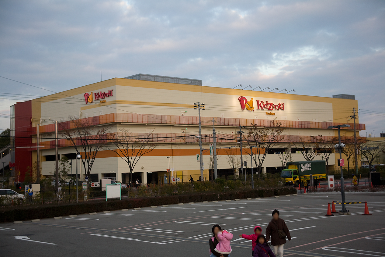
KidZania Koshien
Monument and historic site · 4.8 km
Family edutainment center amusement park

Kobe College
School · 7.7 km
Higher education institution in Hyōgo Prefecture, Japan


Kwansei Gakuin University
School · 8.6 km
Private university in Hyōgo, Japan

Minato Bridge
Bridge · 8.3 km
1974 double-deck cantilever truss bridge

Morinomiya University of Medical Sciences
School · 8.4 km
Higher education institution in Osaka Prefecture, Japan

Orix Theater
Cinema and theater · 8.4 km
Concert hall in Nishi-ku, Osaka, Japan

Osaka Aquarium Kaiyukan
Zoo and aquarium · 7.0 km
Aquarium in Osaka, Japan
13 more on the map.
Museums and landmarks104




Itami City Museum of Insects
Museum · 8.5 km
Museum in Hyōgo Prefecture, Japan

Museum of Oriental Ceramics, Osaka
Museum · 8.5 km
Art museum in Osaka, Japan


Tano Site
Monument and historic site · 6.3 km
Archaeological site in Japan

the Grand Ring
Monument and historic site · 8.2 km
Wooden structure at the Expo 2025 Osaka

92 more on the map.
Parks, trails and playgrounds45

Hattori Ryokuchi Park
Park · 9.1 km
Park in Toyonaka, Osaka prefecture




33 more on the map.
Restaurants and cafes299

Ramen DAIKAN HONTEN
Restaurant · Noodle
1912年(大正元年)、後に大貫初代店主となる千坂長治氏は、神戸の外国人居留地にあった中華料理店・杏香楼のシェフ周氏に教えを請うて製麺技術を含む中華そばの作り方を学び、同所浪花町66番館にて開業。戦後に神戸を離れ、現在、尼崎の大貫本店がある場所へ移転。現在は四代店主の千坂創...
Th-Tu 11:30-21:00



287 more on the map.
History
The area of Amagasaki was part of ancient Kawabe District of Settsu Province and has been inhabited since ancient times, with the traces of Yayoi period settlements and many kofun burial mounds found within the city limits. From the Heian period, the area was known for its port of Daimotsuura. During the Edo period, Amagasaki prospered as the castle town of Amagasaki Domain undertake Aoayama and subsequently the Matsudaira clans. The town of Amagasaki was established on April 1, 1889 with the creation of the modern municipalities system. It was elevated to city status on October 1, 1916.
The 1934 Muroto typhoon caused 145 fatalities and much of the city was destroyed by air raids on June 1 and June 15, 1945 during World War II. The 1995 Great Hanshin earthquake also caused considerable damage and 49 fatalities. Amagasaki was designated a special city on April 1, 2001 with increased local autonomy. A commuter train derailed on the Fukuchiyama Line near Amagasaki on April 25, 2005, resulting in more than 100 dead and 550 injured. On April 1, 2009, Amagasaki was elevated to the status of a core city.
From the History section of Amagasaki on Wikipedia, under CC BY-SA 4.0.
Where to stay9
Churches and places of worship37
Shopping38
Gas and EV charging2
Schools, colleges and libraries10
Healthcare37
Map of Amagasaki
250 places. The map loads OpenStreetMap tiles when you open it.
Getting there and nearby towns
Osaka Itami Airport (ITM) is the nearest airport with scheduled flights listed in OpenStreetMap, 8 km away.
- Osaka 8 km east, about 8 min by car
- Itami 8 km north, about 8 min by car
- Takarazuka 11 km northwest, about 11 min by car
- Kawanishi 11 km north, about 11 min by car
- Kobe 22 km west, about 22 min by car
- Sandachō 25 km northwest, about 25 min by car
- Akashi 38 km west, about 38 min by car
- Kyoto 46 km northeast, about 46 min by car
- Kakogawachō-honmachi 54 km west, about 54 min by car
- Himeji 66 km west, about 1 h by car
Drive times are estimates from straight-line distance, not routes.
Local news
Headlines from INDB.
Reviews, tips and questions
Loading what members have shared...
Sources and licences
- GeoNames (CC BY 4.0): population, coordinates, regions and time zone
- OpenStreetMap contributors (ODbL 1.0): places, airports, map data
- Wikidata (CC0 1.0): elevation, founding date, time zone, website, landmarks and historic places
- Wikimedia Commons (see each image): photos
- Wikipedia (CC BY-SA 4.0): overview and history text
Photo credits
- Archaic Hall Amagasaki Hyogo02s3s2550, 663highland, CC BY 2.5
- Amagasaki City Library01bbs3s3840, 663highland, CC BY 2.5
- Amagasaki shinkin Head-office, Kanko3131, CC BY-SA 3.0
- Hanshin Amagasaki Station220326, GOLFLF, CC BY-SA 4.0
- Hanshin Amagasaki station platform - panoramio - DVMG, DVMG, CC BY 3.0
- Hanshin Amagasaki station platform - panoramio, DVMG, CC BY 3.0
- Amagasaki Station Nishi OsakaNamba Line platform, misijp, CC BY-SA 2.0
- Hanshin9207F at Amagasaki Station, Taksan rok, CC BY-SA 4.0
- Hanshin Amagasaki Station platform - panoramio (11), DVMG, CC BY 3.0
- Hanshin Amagasaki Station platform - panoramio (10), DVMG, CC BY 3.0
- Hanshin Amagasaki Station platform - panoramio (2), DVMG, CC BY 3.0
- TOHO CINEMAS Umeda in 201409, Mc681, CC BY-SA 4.0
- Hyogo Performing Arts Center night, User:Poprishchin, Public domain
- Vories kc 02, Miya, CC BY-SA 3.0
- Konohana Ohashi Osaka JPN 002-edit, ignis, CC BY-SA 3.0
- Koraibashi Osaka JPN 001, ignis, CC BY-SA 3.0
- 170311 Kwansei Gakuin University Nishinomiya Hyogo pref Japan08n, 663highland, CC BY-SA 4.0
- Minato Ohashi Osaka JPN 001, ignis, CC BY-SA 3.0
- ORIX Theater, KishujiRapid, CC BY-SA 4.0
- Osaka Kaiyukan01s3872, 663highland, CC BY 2.5
- Amashin-alkaic, Kanko3131, CC BY-SA 3.0
- Itami City Museum of Insects1, KENPEI, CC BY-SA 3.0
- The Museum of Oriental Ceramics, Osaka 20250831, 掬茶, CC BY-SA 4.0
- Nakanoshima Museum of Art Osaka, Прикли, CC BY 4.0
- NMAO01s3200, 663highland, CC BY 2.5
- Osaka science museum01s3200, 663highland, CC BY 2.5
- Tano Site pit dwelling, MChew, CC BY-SA 4.0
- 大屋根リング, Tatsuya tetsudo, CC0
- 151128 Hattori Ryokuchi Park Osaka pref Japan01s3, 663highland, CC BY 2.5
- UtsuboPark-RoseGarden02, inoue-hiro, CC BY-SA 3.0
- Yahataya-park, KENPEI, CC BY-SA 3.0
- Zenshoji (Amagasaki, Hyogo)1, KENPEI, CC BY-SA 3.0
- Daikakuji (Amagasaki, Hyogo)1, KENPEI, CC BY-SA 3.0
- Nyoraiin2, KENPEI, CC BY-SA 3.0
- 尼信博物館, 投稿者が撮影, Public domain
- Amagasaki Castle Tenshu 20181125, KishujiRapid, CC BY-SA 4.0
- JNR Fukuchiyama-Line Amagasaki-kou sta, H.Torisu, Public domain
- 廣徳寺1, 投稿者が撮影, Public domain
- Honkoji (Amagasaki, Hyogo) hondo, KENPEI, CC BY-SA 3.0
- Hotel New Archaic01s3s3450, 663highland, CC BY 2.5
- Amagasaki City Meijyo elementary school, KishujiRapid, CC BY-SA 4.0
- 2015 1024 Amaebisu Haiden, Hirojin taja, CC BY-SA 4.0
- 2015 1031 Ama Kifune South Torii, Hirojin taja, CC BY-SA 4.0
- 2016 0505 Omononushi Shrine Torii, Hirojin taja, CC BY-SA 4.0
- Hatsushima jinja, Bittercup, CC BY 4.0
- D51 8 in Daimotsu Park, Saigen Jiro, CC0
- Morinomiya University of Medical Sciences1, KENPEI, CC BY-SA 3.0
- Kizzania, wiki0001, CC BY 3.0
- Maishima Sports Islands, NASA World Wind, Public domain
- Hyogo Prefectural Amagasaki High School, KishujiRapid, CC BY-SA 4.0
- Amagasaki City Naniwa elementary school, KishujiRapid, CC BY-SA 3.0
- Amagasaki city Takeya elem-sch, Bakkai, CC BY 3.0
- Amagasaki City Seiryo junior high school, KishujiRapid, CC BY-SA 4.0
- Amagasaki City Jyounai High School and Kotonoura High School, KishujiRapid, CC BY-SA 4.0


Page built November 4, 2026. Spotted a mistake? Tell us or suggest a place.