


Laconia, New Hampshire
Laconia is a city of 17,085 people in Belknap County, New Hampshire, founded in 1855.
Why visit Laconia
Townapedia lists 28 museums and landmarks, 36 parks and trails, 36 places to eat, 12 places to stay and 9 attractions in and around town.
Highlights include Weirs Drive-In Theater, BankNH Pavilion, Funspot and Bay Meeting House and Vestry.
July is the warmest month, with average highs of 82°F; January lows average 12°F, and about 62 inches of snow fall in a normal year.
Weather in Laconia
Forecast from the National Weather Service. Full forecast
About Laconia
Laconia is a city in Belknap County, New Hampshire, United States. The population was 16,871 at the 2020 census, and an estimated 17,246 in 2025, up from 15,951 at the 2010 census. It is the county seat of Belknap County. Laconia, situated between Lake Winnipesaukee and Lake Winnisquam, includes the villages of Lakeport and Weirs Beach.
From the Wikipedia article Laconia, New Hampshire (this version), under CC BY-SA 4.0.
Things to do9


BankNH Pavilion
Cinema and theater · 3.0 mi
American ampitheater in Gilford, New Hampshire USA

Winnipesaukee Playhouse
Cinema and theater · 4.4 mi
Theater in Meredith, New Hampshire, United States


Museums and landmarks28

Funspot
Monument and historic site · 2.6 mi
579 Endicott Street North
Su-Th 10:00-22:00,Fr 10:00-23:00,Sa 10:00-24:00

Bay Meeting House and Vestry
Monument and historic site · National Register of Historic Places · 3.8 mi
Building in New Hampshire, United States
40-36 Steele Hill road, Sanbornton

John W. Busiel House
Monument and historic site · National Register of Historic Places · 3.3 mi
Historic house in New Hampshire, United States
30 Church Street, Laconia

Laconia Passenger Station
Monument and historic site · National Register of Historic Places · 3.3 mi
Railway station in Laconia, the United States of America

Benjamin Rowe House
Monument and historic site · National Register of Historic Places · 4.6 mi
Historic house in New Hampshire, United States

Busiel-Seeburg Mill
Monument and historic site · National Register of Historic Places · 3.4 mi
1 Mill Plaza, Laconia

Colonial Theatre Complex
Monument and historic site · National Register of Historic Places · 3.4 mi
Group of historic buildings in Laconia, New Hampshire

District No. 9 Schoolhouse
Monument and historic site · National Register of Historic Places · 5.4 mi
School building in Gilford, United States of America
Federal Building
Monument and historic site · National Register of Historic Places · 3.2 mi
Federal building in Laconia, New Hampshire

Gale Memorial Library
Monument and historic site · National Register of Historic Places · 3.3 mi
Library in Laconia, New Hampshire, United States
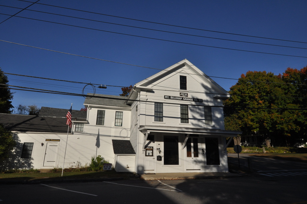
John J. Morrill Store
Monument and historic site · National Register of Historic Places · 4.3 mi
General store and grange hall in Gilford, New Hampshire


Kimball Castle
Monument and historic site · National Register of Historic Places · 5.2 mi
Gilford, New Hampshire, listed on the NRHP in Belknap County
16 more on the map.
Parks, trails and playgrounds36


Loon Sanctuary
Hiking and trails · 3.2 mi
No boat access. Marked off by line with floating milk jugs. Strives to allow Lake Winnisquam's loons nest and lay eggs without...
24 more on the map.
Restaurants and cafes36

Lobster in the Rough
Restaurant · Seafood · 2.5 mi
279 Lakeside Avenue, Laconia
Mo-Th 11:30-20:30; Fr-Su 11:30-20:00

My Coffee House
Cafe · Coffee Shop · 3.7 mi
92 Court Street
Mo-Fr 06:30-17:00; Sa 07:30-16:00
South End Pizza & Seafood
Restaurant · Pizza · 3.9 mi
302 South Main Street, Laconia
11:00-20:30

Defiant
Bar and pub · 3.4 mi
609 Main Street, Laconia
Tu-Th 11:30-20:00; Fr-Sa 11:30-21:00

Pizza Express
Restaurant · Pizza · 3.8 mi
4 Country Club Road, Gilford
Brick Front Restaurant & Lounge
Restaurant · 3.2 mi
134 Church Street, Laconia
24 more on the map.
History
A large Abenaki Indian settlement called Aquadoctan once existed at the point now known as The Weirs, named by colonists for fishing weirs discovered at the outlet of the Winnipesaukee River. Early explorers had hoped to follow the Piscataqua River north to Lake Champlain in search of the great lakes and rivers of Canada mentioned in Indian folklore. About 1652, the Endicott surveying party visited the area, an event commemorated by Endicott Rock, a local landmark. A fort would be built at Laconia in 1746. But ongoing hostilities between the English, French, and their respective Native American allies prevented settlement until 1761, after which it remained for many years a part of Meredith and Gilford called Meredith Bridge.
From the History section of Laconia, New Hampshire on Wikipedia, under CC BY-SA 4.0.
Where to stay12
Churches and places of worship25
United Baptist Church of Lakeport
Church · Baptist · National Register of Historic Places · 2.1 mi
Evangelical Baptist Church
Church · National Register of Historic Places · 3.3 mi
First Free Will Baptist Church
Church · National Register of Historic Places · 5.6 mi
First United Methodist Church of Gilford-Laconia
Church · United Methodist · 3.6 mi
18 Wesley Way, Gilford
Shopping11
Gas and EV charging6
Schools, colleges and libraries13
Healthcare6
Lakes Region Mental Health Center
Clinic and pharmacy · 3.4 mi
40 Beacon Street East, Laconia
Map of Laconia
182 places. The map loads OpenStreetMap tiles when you open it.
Climate by month
Monthly table
| Month | High | Low | Rain | Snow |
|---|---|---|---|---|
| Jan | 30°F | 12°F | 3.1 in | 18.8 in |
| Feb | 34°F | 12°F | 2.9 in | 16.9 in |
| Mar | 42°F | 21°F | 3.4 in | 9.4 in |
| Apr | 56°F | 33°F | 3.6 in | 1.6 in |
| May | 68°F | 44°F | 3.5 in | 0.0 in |
| Jun | 77°F | 55°F | 4.4 in | 0.0 in |
| Jul | 82°F | 60°F | 4.6 in | 0.0 in |
| Aug | 81°F | 59°F | 3.9 in | 0.0 in |
| Sep | 73°F | 52°F | 3.8 in | 0.0 in |
| Oct | 60°F | 40°F | 4.8 in | 0.3 in |
| Nov | 47°F | 30°F | 3.7 in | 2.1 in |
| Dec | 36°F | 20°F | 3.9 in | 12.8 in |
U.S. Climate Normals 1991-2020 for Lakeport 2 (2 mi away), NOAA NCEI.
People and cost of living
American Community Survey 5-year estimates, 2020-2024, U.S. Census Bureau. Estimates have margins of error, larger for small towns.
Disaster history
Belknap County has had 23 federal disaster declarations since 2000, most often for severe storms.
- 2024-07-10: Severe Winter Storm And Flooding (Winter Storm)
- 2023-09-14: Severe Storms And Flooding (Flood)
- 2023-03-15: Severe Storm And Flooding (Severe Storm)
- 2020-04-03: Covid-19 Pandemic (Biological)
- 2020-03-13: Covid-19 (Biological)
- 2018-01-02: Severe Storm And Flooding (Severe Storm)
OpenFEMA disaster declarations summaries.
Getting there and nearby towns
Laconia Municipal Airport (LCI) is the nearest airport with scheduled flights listed in OpenStreetMap, 3 miles away.
- Concord 24 mi south, about 39 min by car
- Sanford 38 mi east, about 1 h by car
- Dover 40 mi southeast, about 1 h by car
- Manchester 41 mi south, about 1 h by car
- Durham 41 mi southeast, about 1 h by car
- Claremont 45 mi west, about 1 h 15 min by car
- Derry 49 mi south, about 1 h 15 min by car
- Saco 53 mi east, about 1 h 30 min by car
- Biddeford 55 mi east, about 1 h 30 min by car
- Hampton 55 mi southeast, about 1 h 30 min by car
Drive times are estimates from straight-line distance, not routes.
Local news
Headlines from INDB, the NEMICO news database.
Reviews, tips and questions
Loading what members have shared...
Sources and licences
- NCES EDGE (Public domain): public schools
- NOAA NCEI U.S. Climate Normals 1991-2020 (Public domain): climate by month
- OpenFEMA (Public domain): disaster declarations
- OpenStreetMap contributors (ODbL 1.0): places, airports, map data
- U.S. Census Bureau (Public domain): population, income, housing, education, commute
- Wikidata (CC0 1.0): elevation, founding date, time zone, website, landmarks and historic places
- Wikimedia Commons (see each image): photos
- Wikipedia (CC BY-SA 4.0): overview and history text
Photo credits
- LaconiaNH NHVeteransAssoc 2, Magicpiano, CC BY-SA 3.0
- LaconiaNH NHVeteransAssoc 1, Magicpiano, CC BY-SA 3.0
- LaconiaNH NHVeteransAssoc 3, Magicpiano, CC BY-SA 3.0
- Keewakwa Abenaki Keenahbeh LaconiaNH 20160911, Sculptor: Peter Wolf Toth / Photo by: Niranjan Arminius, CC BY-SA 4.0
- Federal Building, Laconia NH, John Phelan, CC BY-SA 3.0
- Busiel House, Ken Gallager at English Wikipedia, Public domain
- United Baptist Lakeport, Ken Gallager, Public domain
- Laconia RR Station, Ken Gallager at English Wikipedia, CC BY-SA 3.0
- Evangelical Baptist Church, Ken Gallager at en.wikipedia, Public domain
- First Free Will Meredith, Ken Gallager at en.wikipedia, CC BY-SA 3.0
- Goss Reading Room, Ken Gallager at en.wikipedia, Public domain
- Laconia Library, Found5dollar, CC BY-SA 3.0
- Laconia Post Office, Ken Gallager at en.wikipedia, Public domain
- Kimball Castle, Ken Gallager at English Wikipedia, Public domain
- Benjamin Rowe House, Ken Gallager at English Wikipedia, Public domain
- GilfordNH District9Schoolhouse, Magicpiano, CC BY-SA 3.0
- Meredith Public Library, Ken Gallager ( talk ), CC BY-SA 3.0
- Laconia District Court, Ken Gallager at English Wikipedia, Public domain
- Colonial Theatre Complex, Doug Kerr, CC BY-SA 2.0
- GilfordNH MtBelknapGrange, Magicpiano, CC BY-SA 3.0
- Busiel-Seeburg, Ken Gallager at en.wikipedia, Public domain
- Entrance BankNH Pavilion 108 Kimball Road Gilford NH July 2026, Artaxerxes, CC BY 4.0
- Winnipesaukee Playhouse, Alexa15224, CC BY-SA 3.0
- SanborntonNH BayMeetingHouse, Magicpiano, CC BY-SA 4.0
- Belknap-Sulloway, Ken Gallager at en.wikipedia, Public domain
- ISS063-E-106666 - View of Earth, Earth Science and Remote Sensing Unit, NASA Johnson Space Center, Public domain
- ISS040-E-113028 - View of Earth, Earth Science and Remote Sensing Unit , Lyndon B. Johnson Space Center, Public domain
- ISS035-E-39207 - View of Earth, Earth Science and Remote Sensing Unit , Lyndon B. Johnson Space Center, Public domain
- ISS063-E-106665 - View of Earth, Earth Science and Remote Sensing Unit, NASA Johnson Space Center, Public domain
- ISS032-E-27280 - View of Massachusetts, Earth Science and Remote Sensing Unit , Lyndon B. Johnson Space Center, Public domain
- ISS040-E-113027 - View of Earth, Earth Science and Remote Sensing Unit , Lyndon B. Johnson Space Center, Public domain
- EndicottRock 5, Magicpiano, CC BY-SA 3.0
- EndicottRock 3, Magicpiano, CC BY-SA 3.0
- EndicottRock 1, Magicpiano, CC BY-SA 3.0
- EndicottRock 2, Magicpiano, CC BY-SA 3.0
- EndicottRock 4, Magicpiano, CC BY-SA 3.0
- The Donkey Kong, walknboston, CC BY 2.0
- Rolling Thunder arcade cabinet, TarkusAB, CC BY-SA 4.0
- Sunset on Opechee Bay, Chris Rycroft, CC BY 2.0
- Keewakwa Abenaki Keenahbeh Oblique2 20160911, Sculptor: Peter Wolf Toth / Photo: Niranjan Arminius, CC BY-SA 4.0


Page built October 30, 2026. Spotted a mistake? Tell us or suggest a place.