


Lake Arbor, Maryland
Lake Arbor is a community of 14,335 people in Prince George's County, Maryland.
Why visit Lake Arbor
Townapedia lists 7 museums and landmarks, 15 parks and trails, 47 places to eat, 12 places to stay and 2 attractions in and around town.
Highlights include AMC, Six Flags America, Beall's Pleasure and Concord.
July is the warmest month, with average highs of 88°F; January lows average 22°F.
Weather in Lake Arbor
Forecast from the National Weather Service. Full forecast
About Lake Arbor
Lake Arbor is an unincorporated area and census-designated place (CDP) in Prince George's County, Maryland, United States. The population was 14,541 at the 2020 census. The ZIP Codes encompassing the CDP area are 20721 and 20774.
From the Wikipedia article Lake Arbor, Maryland (this version), under CC BY-SA 4.0.
Things to do2


Six Flags America
Monument and historic site · 3.2 mi
Former amusement park in Woodmore, Maryland
Museums and landmarks7

Beall's Pleasure
Monument and historic site · National Register of Historic Places · 3.3 mi
Historic house in Landover, Maryland, United States
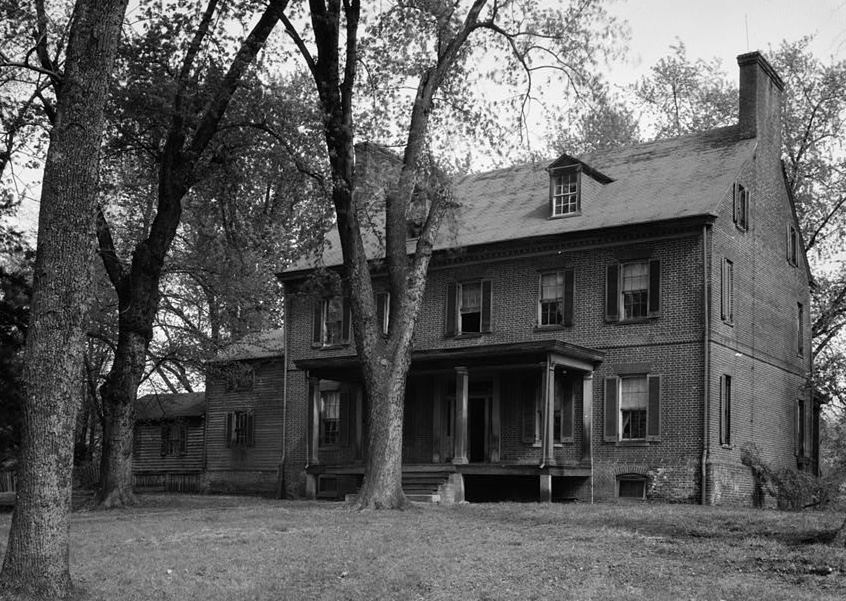
Concord
Monument and historic site · National Register of Historic Places · 2.9 mi
Historic house in District Heights, Maryland, United States

Glenn Dale Hospital
Monument and historic site · National Register of Historic Places · 3.7 mi
Former hospital in Maryland, United States

Mount Lubentia
Monument and historic site · National Register of Historic Places · 2.0 mi
Human settlement in Maryland, United States of America

Pleasant Prospect
Monument and historic site · National Register of Historic Places · 3.2 mi
Building in Maryland, United States

Ridgeley School
Monument and historic site · National Register of Historic Places · 2.0 mi
Historic school in Capitol Heights, Maryland, United States

Thomas J. Calloway House
Monument and historic site · National Register of Historic Places · 3.9 mi
Historic house in Maryland, United States
Parks, trails and playgrounds15



Belt Woods
Park · 3.7 mi
Nature reserve in the U.S. state of Maryland


3 more on the map.
Restaurants and cafes47


Hook & Reel
Restaurant · Seafood, Cajun · 1.3 mi
9201 Woodmore Centre Drive, Lanham
12:00-22:00; Fr,Sa 12:00-24:00
Outback Steakhouse
Restaurant · American, Steak · 0.5 mi
9660 Lottsford Court, Upper Marlboro
Mo-Th 11:00-22:00; Fr,Sa 11:00-23:00; Su 11:00-21:00
Silver Diner
Restaurant · American, Diner · 1.3 mi
9151 Ruby Lockhart Boulevard, Lanham
Su-Th 07:00-23:00, Fr-Sa 07:00-00:00
Spiced Black
Restaurant · Salad, African, American · 1.1 mi
10420 Campus Way South, Upper Marlboro
Mo-Su 11:00-21:00
Nando's
Restaurant · Chicken, Portuguese · 1.2 mi
2700 Campus Way North, Lanham
Su-Th 10:30-22:00; Fr,Sa 10:30-23:00

35 more on the map.
History
Lake Arbor was originally known as Newbridge, a development of Levitt & Sons, developers of the early planned communities of Levittown in Pennsylvania and Long Island, New York, respectively. When the project went bankrupt in the mid-1970s after selling only 41 houses, Manufacturer's Hanover Trust acquired the debt and held it as REO (real estate owned) for approximately 10 years until a limited partnership composed of David A. Gitlitz, Alvin Dworman, Phillip Abrahms, Phillip D. Winn, and Gary S. Lachman acquired it. Under the direction of Gitlitz, and with technical engineering assistance from Abrahms, Lachman changed the name of the property to Lake Arbor.
From the History section of Lake Arbor, Maryland on Wikipedia, under CC BY-SA 4.0.
Where to stay12
Holiday Inn Express & Suites
Motel and hotel · 1.0 mi
9101 Basil Court, Upper Marlboro
Churches and places of worship12
Ridgley Methodist Episcopal Church
Church · National Register of Historic Places · 1.6 mi
Shopping7
Gas and EV charging3
Schools, colleges and libraries60
Healthcare4
Capital Region Medical Center
Hospital · 0.8 mi
901 North Harry S Truman Drive, Largo
Advanced Urgent Care - Kaiser Permanente Largo Medical Center
Clinic and pharmacy
1221 Mercantile Lane, Largo
Plumbers Local 5 Health & Wellness Center
Clinic and pharmacy
10236 Lake Arbor Way, Bowie
Map of Lake Arbor
169 places. The map loads OpenStreetMap tiles when you open it.
Climate by month
Monthly table
| Month | High | Low | Rain | Snow |
|---|---|---|---|---|
| Jan | 44°F | 22°F | 3.0 in | 5.7 in |
| Feb | 47°F | 23°F | 2.7 in | 6.3 in |
| Mar | 55°F | 31°F | 3.9 in | 1.7 in |
| Apr | 66°F | 41°F | 3.4 in | 0.0 in |
| May | 75°F | 51°F | 4.1 in | 0.0 in |
| Jun | 82°F | 61°F | 4.2 in | 0.0 in |
| Jul | 88°F | 66°F | 4.2 in | 0.0 in |
| Aug | 87°F | 65°F | 4.1 in | 0.0 in |
| Sep | 79°F | 57°F | 4.5 in | 0.0 in |
| Oct | 68°F | 44°F | 4.1 in | 0.0 in |
| Nov | 57°F | 33°F | 3.2 in | 0.0 in |
| Dec | 48°F | 27°F | 3.5 in | 2.2 in |
U.S. Climate Normals 1991-2020 for Glenn Dale Bell Stn Hcn (4 mi away), rain and snow from Upper Marlboro 3 Nnw, NOAA NCEI.
People and cost of living
American Community Survey 5-year estimates, 2020-2024, U.S. Census Bureau. Estimates have margins of error, larger for small towns.
Disaster history
Prince George's County has had 13 federal disaster declarations since 2000, most often for hurricanes.
- 2026-01-24: Severe Winter Storm (Winter Storm)
- 2020-03-26: Covid-19 Pandemic (Biological)
- 2020-03-13: Covid-19 (Biological)
- 2016-03-04: Severe Winter Storm And Snowstorm (Snowstorm)
- 2012-11-20: Hurricane Sandy (Hurricane)
- 2012-10-28: Hurricane Sandy (Hurricane)
OpenFEMA disaster declarations summaries.
Getting there and nearby towns
College Park Airport (CGS) is the nearest airport with scheduled flights listed in OpenStreetMap, 7 miles away.
- Largo 2 mi south, about 3 min by car
- Summerfield 2 mi west, about 3 min by car
- Glenarden 2 mi northwest, about 3 min by car
- Springdale 2 mi north, about 3 min by car
- Mitchellville 2 mi northeast, about 4 min by car
- Kettering 3 mi southeast, about 4 min by car
- Landover 3 mi west, about 5 min by car
- Peppermill Village 3 mi west, about 5 min by car
- Woodmore 3 mi east, about 5 min by car
- Capitol Heights 3 mi southwest, about 6 min by car
Drive times are estimates from straight-line distance, not routes.
Local news
Headlines from INDB, the NEMICO news database.
Reviews, tips and questions
Loading what members have shared...
Sources and licences
- NCES EDGE (Public domain): public schools
- NOAA NCEI U.S. Climate Normals 1991-2020 (Public domain): climate by month
- OpenFEMA (Public domain): disaster declarations
- OpenStreetMap contributors (ODbL 1.0): places, airports, map data
- U.S. Census Bureau (Public domain): population, income, housing, education, commute
- Wikidata (CC0 1.0): elevation, founding date, time zone, website, landmarks and historic places
- Wikimedia Commons (see each image): photos
- Wikipedia (CC BY-SA 4.0): overview and history text
Photo credits
- Lake Arbor, SlipperyDude, CC BY-SA 3.0
- 2020-08-26 17 28 17 View south along Maryland State Route 202 (Landover Road) at the exit for Maryland State Route 214 WEST (Central Avenue, Washington, TO Interstate 95) in Lake Arbor, Prince..., Famartin, CC BY-SA 4.0
- 2020-08-26 15 31 53 View north along Maryland State Route 202 (Landover Road) from the overpass for Maryland State Route 214 (Central Avenue) in Lake Arbor, Prince George's County, Maryland, Famartin, CC BY-SA 4.0
- 2020-08-26 17 29 36 View south along Maryland State Route 202 (Landover Road) at the exit for Maryland State Route 214 EAST (Central Avenue, Annapolis) in Lake Arbor, Prince George's County, Maryland, Famartin, CC BY-SA 4.0
- 2020-08-30 15 13 58 View east along Maryland State Route 214 (Central Avenue) at the exit for Maryland State Route 202 NORTH (Largo) on the edge of Kettering and Lake Arbor in Prince George's County..., Famartin, CC BY-SA 4.0
- 2020-08-20 10 36 11 View west along Maryland State Route 214 (Central Avenue) at the exit for Maryland State Route 202 NORTH (Largo) on the edge of Kettering and Lake Arbor in Prince George's County..., Famartin, CC BY-SA 4.0
- 2020-08-30 15 17 59 View east along Maryland State Route 214 (Central Avenue) just east of Campus Way on the edge of Kettering and Lake Arbor in Prince George's County, Maryland, Famartin, CC BY-SA 4.0
- Glenn Dale Hospital - Adult Hospital Building, Rosa Pineda, CC BY-SA 3.0
- Mt Lubentia Jan 09, Pubdog at en.wikipedia, Public domain
- Ridgley Methodist Episcopal Church Dec 08, Pubdog ( talk ), Public domain
- Bealls Pleasure 1936 HABS, John O. Brostrup, Public domain
- Concord 1936, Historic American Buildings Survey / Historic American Engineering Record, Public domain
- Thomas J. Calloway House Dec 10, Pubdog, Public domain
- Ridgeley Rosenwald School, exterior (21636807881), Preservation Maryland, CC BY-SA 2.0
- BeltWoods1a, Valerius Tygart, CC BY-SA 3.0
- Metropolitan Baptist Church, SlipperyDude, CC BY-SA 3.0
- SFA-Joker's Jinx, Chris Hagerman, CC BY-SA 3.0
- FBC Glenarden (cropped), Gravada, CC BY 4.0
- 2006 09 12 - 202@Arena-LakeArbor - Westbound 05, Andrew Bossi, CC BY-SA 2.5
- Sciurus carolinensis 342335938, Ken Clark, CC BY 4.0
- 2020-08-26 15 29 07 View south along Maryland State Route 202 (Largo Road) from the overpass for Maryland State Route 214 (Central Avenue) on the edge of Largo and Kettering in Prince George's..., Famartin, CC BY-SA 4.0
- 2017-06-03 12 08 17 View south along Maryland State Route 977 (Old Largo Road) at Maryland State Route 214 (Central Avenue) in Kettering, Prince George's County, Maryland, Famartin, CC BY-SA 4.0
- 2020-08-26 15 27 26 View north along Maryland State Route 202 (Largo Road) at the exit for Maryland State Route 214 WEST (Central Avenue, Washington) on the edge of Largo and Kettering in Prince..., Famartin, CC BY-SA 4.0
- Lake Largo, Jsallie2, CC BY-SA 4.0
- Largo Town Center tail tracks (50077036652), Ben Schumin from Montgomery Village, Maryland, USA, CC BY-SA 2.0
- WMATA railcar 2046 at Largo Town Center, Ben Schumin, CC BY-SA 2.0
- Owen Hart 1997, ae! from arlington, USA, CC BY 2.0
- Decommissioned transfer ticket machine (50555599411), Ben Schumin from Montgomery Village, Maryland, USA, CC BY-SA 2.0
- Largo Town Center station -01- (50961667867), Ben Schumin from Montgomery Village, Maryland, USA, CC BY-SA 2.0
- Washington DC metro station largo town center, Schuminweb (Ben Schumin), CC BY-SA 3.0
- Train at Largo Town Center, Ben Schumin, CC BY-SA 3.0
- FedEx Field from Largo Town Center garage (50961566351), Ben Schumin from Montgomery Village, Maryland, USA, CC BY-SA 2.0
- Silver Line – Largo Town Center, Ryan Stavely, CC BY-SA 2.0
- David Bowie, Wash. DC (1974) (9380409028), Hunter Desportes, CC BY 2.0
- David Bowie, Wash. DC (1974) (9377623649), Hunter Desportes, CC BY 2.0
- David Bowie, Wash. DC (1974) (9377622579), Hunter Desportes, CC BY 2.0
- David Bowie, Wash. DC (1974) (9372627220), Hunter Desportes, CC BY 2.0
- David Bowie, Wash. DC (1974) (9380408584), Hunter Desportes, CC BY 2.0
- David Bowie, Wash. DC (1974) (9377622761), Hunter Desportes, CC BY 2.0
- David Bowie, Wash. DC (1974) (9377623231), Hunter Desportes, CC BY 2.0


Page built October 30, 2026. Spotted a mistake? Tell us or suggest a place.