


Capitol Heights, Maryland
Capitol Heights is a town of 4,020 people in Prince George's County, Maryland, founded in 1910.
Why visit Capitol Heights
Townapedia lists 7 museums and landmarks, 10 parks and trails and 13 places to eat in and around town.
Highlights include Concord, Fairmount Heights Historic District, Millwood Recreation Center and Walker Mill Regional Park.
July is the warmest month, with average highs of 90°F; January lows average 28°F.
Weather in Capitol Heights
Forecast from the National Weather Service. Full forecast
About Capitol Heights
Capitol Heights is a town in Prince George's County, Maryland, United States, located on the border of both the Northeast & Southeast quadrants of Washington. Per the 2020 census, the population was 4,050. The town of Capitol Heights is officially bounded between Southern Avenue NE/SE to the north, Yost Place, and Eastern Avenue NE to the east, the Watts Branch Stream, Brooke Road, and Capitol Heights Boulevard to the south, and Marlboro Pike to the west. The zip code of Capitol Heights is 20743.
From the Wikipedia article Capitol Heights, Maryland (this version), under CC BY-SA 4.0.
Museums and landmarks7
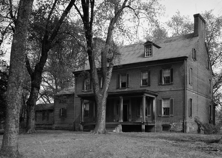
Concord
Monument and historic site · National Register of Historic Places · 0.7 mi
Historic house in District Heights, Maryland, United States

Fairmount Heights Historic District
Monument and historic site · National Register of Historic Places · 2.6 mi
Historic district in Maryland, USA

Mount Lubentia
Monument and historic site · National Register of Historic Places · 3.4 mi
Human settlement in Maryland, United States of America

Nannie Helen Burroughs School
Monument and historic site · National Register of Historic Places · 3.1 mi
Historic school formerly named Trades Hall of National Training School for Women and Girls

Ridgeley School
Monument and historic site · National Register of Historic Places · 1.4 mi
Historic school in Capitol Heights, Maryland, United States

Strand Theater
Monument and historic site · National Register of Historic Places · 3.0 mi
Former movie theater in Washington D.C.

Woodlawn Cemetery
Monument and historic site · National Register of Historic Places · 3.3 mi
Cemetery in Washington, D.C.
Parks, trails and playgrounds10



Restaurants and cafes13

Olive Garden
Restaurant · Italian · 1.6 mi
1681 Ritchie Station Court, Capitol Heights
Mo-Th,Su 11:00-22:00; Fr,Sa 11:00-23:00


Sonic
Fast food · Burger · 1.5 mi
8950 Walker Mill Road, Capitol Heights
Mo-Th 09:00-23:00; Fr-Sa 09:00-24:00; Su 10:00-23:00
Domino's
Fast food · Pizza · 1.4 mi
6254 Central Avenue, Capitol Heights
Mo-Th 10:00-24:00; Fr-Sa 10:00-01:00; Su 10:00-24:00
Dunkin'
Fast food · Donut, Coffee Shop · 1.3 mi
6412 Central Avenue, Capitol Heights
Mo-Fr 05:00-20:00; Sa-Su 06:00-20:00
Panda Express
Fast food · Chinese · 1.7 mi
1620 Ritchie Station Court, Capitol Heights
Mo-Fr 09:30-23:00; Sa 10:00-22:30; Su 10:00-22:00
Popeyes
Fast food · Chicken · 1.5 mi
6214 Central Avenue, Seat Pleasant
Mo-Th 10:00-23:00; Fr-Sa 10:00-24:00; Su 10:00-23:00
Taco Bell
Fast food · Tex-Mex · 1.4 mi
6250 Central Avenue, Capitol Heights
Mo-Th 08:00-02:00; Fr-Sa 08:00-03:00; Su 08:00-02:00
1 more on the map.
Churches and places of worship21

Ridgley Methodist Episcopal Church
Church · National Register of Historic Places · 1.8 mi
Church building in Maryland, United States of America

St. Matthew's Church
Church · National Register of Historic Places · 2.4 mi
Church building in Seat Pleasant, United States of America



Metropolitan Baptist Church
Church · 3.1 mi
Church building in Maryland, United States of America

Kingdom Hall of Jehovahs Witnesses
Church · Jehovahs Witness · 1.3 mi
8009 Darcy Road, District Heights
New Jerusalem Baptist Church
Church · Baptist · 0.7 mi
6802 Walker Mill Road, Capitol Heights
Trinidad Baptist Church
Church · Baptist · 0.9 mi
6611 Walker Mill Road, Capitol Heights
Walker Mill Baptist Church
Church · Baptist · 0.7 mi
6801 Walker Mill Road, Capitol Heights
Way of the Cross Church of Christ
Church · 1.2 mi
1800 Hazelwood Drive, Capitol Heights
9 more on the map.
History
In 1904, Washington, D.C., was growing by leaps and bounds. The overcrowding and the improved public transportation made the idea of living on the outskirts increasingly appealing to people looking for housing. Recognizing the opportunity, Baltimore resident Otway B. Zantzinger acquired 400 hilly acres just beyond the eastern corner of the District of Columbia. He divided the tract into 4,000 lots and began to sell them at prices ranging from $20 to $150 each. He advertised a picturesque view of Washington, D.C., a proposed electric railway, drinking water from crystal-clear springs, nothing down and a dollar a month, no interest, no landlords, and, in the custom and vernacular of the times, "no colored people." Many buyers bought two lots in this haven that was to become Capitol Heights.
While awaiting their "proposed electric railway," commuters to the city could walk about a mile (often through mud) to the District Line station at what is now Seat Pleasant and board a rail car into Washington, DC.
From the History section of Capitol Heights, Maryland on Wikipedia, under CC BY-SA 4.0.
Shopping4
Gas and EV charging8
Schools, colleges and libraries57
Cesar Chavez Public Charter Schools For Public Policy
School · 4.2 mi
3701 Hayes Street Ne, Washington
Elsie Whitlow Stokes Community Freedom Pcs - East End
School · 2.4 mi
5600 East Capitol Street Ne, Washington
Friendship Pcs - Blow Pierce Elementary
School · 5.4 mi
725 19Th Street Ne, Washington
Map of Capitol Heights
120 places. The map loads OpenStreetMap tiles when you open it.
Climate by month
Monthly table
| Month | High | Low | Rain | Snow |
|---|---|---|---|---|
| Jan | 45°F | 28°F | 3.0 in | 4.7 in |
| Feb | 48°F | 30°F | 2.8 in | 2.3 in |
| Mar | 56°F | 36°F | 4.0 in | 1.4 in |
| Apr | 68°F | 46°F | 3.4 in | 0.0 in |
| May | 77°F | 57°F | 4.3 in | 0.0 in |
| Jun | 85°F | 66°F | 4.6 in | 0.0 in |
| Jul | 90°F | 71°F | 4.6 in | 0.0 in |
| Aug | 88°F | 69°F | 3.7 in | 0.0 in |
| Sep | 82°F | 62°F | 4.1 in | 0.0 in |
| Oct | 70°F | 49°F | 4.2 in | 0.0 in |
| Nov | 58°F | 39°F | 3.2 in | 0.0 in |
| Dec | 49°F | 32°F | 3.7 in | 1.3 in |
U.S. Climate Normals 1991-2020 for Natl Arboretum Dc (6 mi away), NOAA NCEI.
People and cost of living
American Community Survey 5-year estimates, 2020-2024, U.S. Census Bureau. Estimates have margins of error, larger for small towns.
Disaster history
Prince George's County has had 13 federal disaster declarations since 2000, most often for hurricanes.
- 2026-01-24: Severe Winter Storm (Winter Storm)
- 2020-03-26: Covid-19 Pandemic (Biological)
- 2020-03-13: Covid-19 (Biological)
- 2016-03-04: Severe Winter Storm And Snowstorm (Snowstorm)
- 2012-11-20: Hurricane Sandy (Hurricane)
- 2012-10-28: Hurricane Sandy (Hurricane)
OpenFEMA disaster declarations summaries.
Getting there and nearby towns
Joint Base Andrews (ADW) is the nearest airport with scheduled flights listed in OpenStreetMap, 4 miles away.
- Walker Mill 1 mi west, about 1 min by car
- Forestville 2 mi south, about 3 min by car
- Summerfield 2 mi north, about 3 min by car
- Suitland 3 mi southwest, about 5 min by car
- Largo 3 mi east, about 5 min by car
- Landover 3 mi north, about 6 min by car
- Lake Arbor 3 mi northeast, about 6 min by car
- Westphalia 4 mi southeast, about 6 min by car
- Kettering 5 mi east, about 8 min by car
- Andrews AFB 5 mi south, about 7 min by car
Drive times are estimates from straight-line distance, not routes.
Local news
Headlines from INDB, the NEMICO news database.
Reviews, tips and questions
Loading what members have shared...
Sources and licences
- NCES EDGE (Public domain): public schools
- NOAA NCEI U.S. Climate Normals 1991-2020 (Public domain): climate by month
- OpenFEMA (Public domain): disaster declarations
- OpenStreetMap contributors (ODbL 1.0): places, airports, map data
- U.S. Census Bureau (Public domain): population, income, housing, education, commute
- Wikidata (CC0 1.0): elevation, founding date, time zone, website, landmarks and historic places
- Wikimedia Commons (see each image): photos
- Wikipedia (CC BY-SA 4.0): overview and history text
Photo credits
- Ridgeley Rosenwald School, exterior (21636807881), Preservation Maryland, CC BY-SA 2.0
- 2016-09-11 12 58 35 View south along Maryland State Route 458 (Walker Mill Road) at Hazelwood Drive in Capitol Heights, Prince Georges County, Maryland, Famartin, CC BY-SA 4.0
- Olive Garden (Capitol Heights, Maryland) (45956708861), Todd Van Hoosear, CC BY-SA 2.0
- Exterior of a modern Panda Express fast-food restaurant in Capitol Heights, Maryland 01, Harrison Keely, CC BY 4.0
- Exterior of a modern Panda Express fast-food restaurant in Capitol Heights, Maryland 05, Harrison Keely, CC BY 4.0
- Exterior of a modern Panda Express fast-food restaurant in Capitol Heights, Maryland 06, Harrison Keely, CC BY 4.0
- Interior of a modern Panda Express fast-food restaurant in Capitol Heights, Maryland 04, Harrison Keely, CC BY 4.0
- Interior of a modern Panda Express fast-food restaurant in Capitol Heights, Maryland 03, Harrison Keely, CC BY 4.0
- Interior of a modern Panda Express fast-food restaurant in Capitol Heights, Maryland 02, Harrison Keely, CC BY 4.0
- Mt Lubentia Jan 09, Pubdog at en.wikipedia, Public domain
- Strand Teater DC, Smallbones, CC0
- Woodlawn Cemetery DC, Smallbones, CC0
- St Matthews Church Sept 09, Pubdog ( talk ), Public domain
- Ridgley Methodist Episcopal Church Dec 08, Pubdog ( talk ), Public domain
- Trades Hall of National Training School for Women and Girls, Farragutful, CC BY-SA 4.0
- Concord 1936, Historic American Buildings Survey / Historic American Engineering Record, Public domain
- Grace United Methodist Church - Fairmount Heights, Maryland, Farragutful, CC BY-SA 4.0
- Metropolitan Baptist Church, SlipperyDude, CC BY-SA 3.0
- Tunnel portal outside Addison Road station (50222856431), Ben Schumin from Montgomery Village, Maryland, USA, CC BY-SA 2.0
- Metro tracks over Cabin Branch Road (50056422207), Ben Schumin from Montgomery Village, Maryland, USA, CC BY-SA 2.0
- Train at Addison Road station (50056176566), Ben Schumin from Montgomery Village, Maryland, USA, CC BY-SA 2.0
- Short section of track in cages (50222856421), Ben Schumin from Montgomery Village, Maryland, USA, CC BY-SA 2.0
- Cities by a Bay (18189198736), John Leszczynski from Washington, DC, USA, CC BY-SA 2.0
- TheBus 63025 at Morgan Boulevard station (50962863127), Ben Schumin from Montgomery Village, Maryland, USA, CC BY-SA 2.0
- Morgan Boulevard station entrance pylon (50076218063), Ben Schumin from Montgomery Village, Maryland, USA, CC BY-SA 2.0
- Farecard machines at Morgan Boulevard station (50960862368), Ben Schumin from Montgomery Village, Maryland, USA, CC BY-SA 2.0
- 2016-09-13 11 01 24 View west along Maryland State Route 332 (Central Avenue) at Yolanda Avenue in Walker Mill, Prince George's County, Maryland, Famartin, CC BY-SA 4.0
- 2020-08-21 10 27 04 View south along Maryland State Route 458 (Silver Hill Road) at Walker Mill Road in Walker Mill, Prince George's County, Maryland, Famartin, CC BY-SA 4.0
- Sandra Dove Pledges to Pool Safely (34734521844), PoolSafely, CC BY 2.0
- Sandra Dove takes the Pool Safely Pledge (35188502410), PoolSafely, CC BY 2.0
- 2018-10-17 15 09 12 View north along Maryland State Route 458 (Silver Hill Road) at Atwood Street and Scott Key Drive in District Heights, Prince George's County, Maryland, Famartin, CC BY-SA 4.0
- 2018-10-17 15 09 31 View south along Maryland State Route 458 (Silver Hill Road) at Atwood Street and Scott Key Drive in District Heights, Prince George's County, Maryland, Famartin, CC BY-SA 4.0
- 2018-10-17 15 06 25 View north along Maryland State Route 458 (Silver Hill Road) just south of Atwood Street and Scott Key Drive in District Heights, Prince George's County, Maryland, Famartin, CC BY-SA 4.0
- 2016-09-11 13 22 26 View west along Maryland State Route 221 (Ritchie-Marlboro Road) at Ritchie Station Court in Forestville, Prince Georges County, Maryland, Famartin, CC BY-SA 4.0
- An Ulta Beauty retail store in Forestville, Maryland, Harrison Keely, CC BY 4.0
- Buffalo Wild Wings restaurant in Ritchie, Maryland 02, Harrison Keely, CC BY 4.0
- Buffalo Wild Wings restaurant in Ritchie, Maryland 01, Harrison Keely, CC BY 4.0


Page built October 30, 2026. Spotted a mistake? Tell us or suggest a place.