


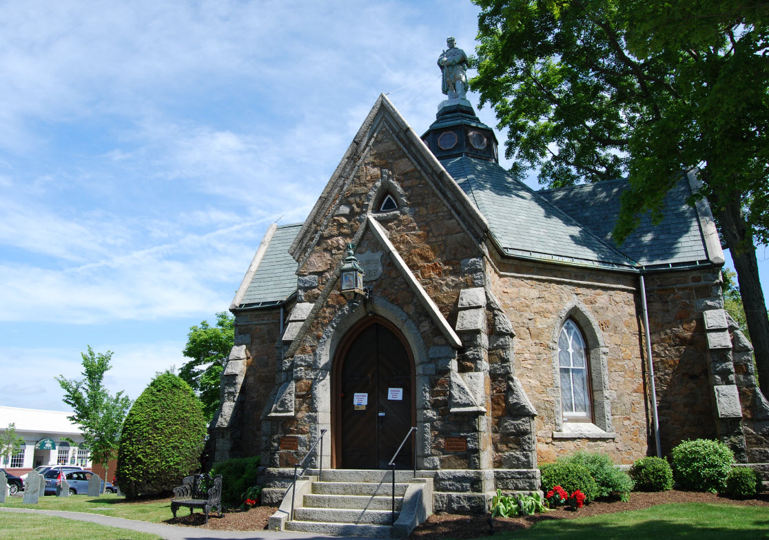


Mansfield Center, Massachusetts
Mansfield Center is a community of 7,222 people in Bristol County, Massachusetts.
Why visit Mansfield Center
Townapedia lists 15 museums and landmarks, 26 parks and trails, 31 places to eat, 6 places to stay and 2 attractions in and around town.
Highlights include Xfinity Center, Capt. Josiah Pratt House, Ezra Carpenter House and Taylor's Hill Conservation Area.
July is the warmest month, with average highs of 82°F; January lows average 18°F, and about 50 inches of snow fall in a normal year.
Weather in Mansfield Center
Forecast from the National Weather Service. Full forecast
About Mansfield Center
Mansfield Center is a census-designated place (CDP) in the town of Mansfield, Massachusetts, United States. As of the 2020 census, Mansfield Center had a population of 7,830.
From the Wikipedia article Mansfield Center, Massachusetts (this version), under CC BY-SA 4.0.
Things to do2

Xfinity Center
Cinema and theater · 2.0 mi
Outdoor theatre in Mansfield, Massachusetts, United States

Museums and landmarks15

Capt. Josiah Pratt House
Monument and historic site · National Register of Historic Places · 3.0 mi
Foxboro, Massachusetts, listed on the NRHP in Norfolk County

Ezra Carpenter House
Monument and historic site · National Register of Historic Places · 2.8 mi
Historic house in Massachusetts, United States
Fisher-Richardson House
Monument and historic site · National Register of Historic Places · 1.0 mi
Historic house in Massachusetts, United States

Foxboro Grange Hall
Monument and historic site · National Register of Historic Places · 3.4 mi
Building in Massachusetts, United States
Memorial Hall
Monument and historic site · National Register of Historic Places · 3.3 mi
Building in Massachusetts, United States of America

Otis Cary House
Monument and historic site · National Register of Historic Places · 2.7 mi
Historic house in Foxboro, Massachusetts, United States

Seth Boyden House
Monument and historic site · National Register of Historic Places · 3.5 mi
Historic house in Massachusetts, United States

Soldiers' Memorial Library
Monument and historic site · National Register of Historic Places
Historic library building in Mansfield, Massachusetts, United States


Spring Brook Cemetery
Monument and historic site · National Register of Historic Places
Historic cemetery in Massachusetts, United States
Lowney Chocolate Factory
Monument and historic site · National Register of Historic Places · 1.2 mi
3 more on the map.
Parks, trails and playgrounds26


14 more on the map.
Restaurants and cafes31

Bangkok Café
Restaurant · Asian, Thai · 1.3 mi
10 Foxborough Boulevard
Mo-Th 11:30-20:00; Fr-Sa 11:30-21:00; Su 04:00-20:00
Cheng-Du
Restaurant · Chinese · 0.6 mi
249 North Main Street, Mansfield
Mo-Th 11:30-22:00, Fr 11:30-23:00, Sa 12:00-23:00, Su 12:00-22:00
Foxboro Mandarin
Restaurant · Asian, Chinese · 1.3 mi
369 Central Street
Mo-Th 11:30-21:20; Fr-Sa 11:30-22:20; Su 12:30-21:20

Jimmy's Pub & Restaurant
Diner · American · 0.4 mi
141 North Main Street, Mansfield
Mo-Th 11:30-22:00, Fr-Sa 11:30-23:00, Su 11:30-21:00
Mansfield House of Pizza
Restaurant · Pizza · 0.4 mi
175 North Main Street, Mansfield
Mo-Th 11:00-22:00, Fr 11:00-23:00, Sa 11:00-22:00, Su 12:00-21:00



Café on the Common
Cafe · Coffee Shop
12 South Main Street, Mansfield
19 more on the map.
Where to stay6
enVision Mansfield-Foxboro
Motel and hotel · 1.8 mi
31 Hampshire Street, Mansfield
Churches and places of worship4
Shopping7
Gas and EV charging5
Schools, colleges and libraries33
Foxborough Regional Charter School
School · 2.8 mi
131 Central Street, Foxborough
Healthcare2
Map of Mansfield Center
131 places. The map loads OpenStreetMap tiles when you open it.
Climate by month
Monthly table
| Month | High | Low | Rain | Snow |
|---|---|---|---|---|
| Jan | 36°F | 18°F | 4.4 in | 14.3 in |
| Feb | 39°F | 19°F | 3.8 in | 12.6 in |
| Mar | 46°F | 26°F | 5.3 in | 10.1 in |
| Apr | 58°F | 35°F | 4.7 in | 1.9 in |
| May | 69°F | 46°F | 3.6 in | 0.0 in |
| Jun | 77°F | 55°F | 4.3 in | 0.0 in |
| Jul | 82°F | 62°F | 3.5 in | 0.0 in |
| Aug | 81°F | 60°F | 3.8 in | 0.0 in |
| Sep | 73°F | 52°F | 4.1 in | 0.0 in |
| Oct | 61°F | 41°F | 5.1 in | 0.2 in |
| Nov | 51°F | 32°F | 4.5 in | 1.2 in |
| Dec | 42°F | 24°F | 5.2 in | 9.2 in |
U.S. Climate Normals 1991-2020 for Norton W (3 mi away), NOAA NCEI.
People and cost of living
American Community Survey 5-year estimates, 2020-2024, U.S. Census Bureau. Estimates have margins of error, larger for small towns.
Disaster history
Bristol County has had 23 federal disaster declarations since 2000, most often for severe storms.
- 2024-05-15: Severe Storms And Flooding (Flood)
- 2023-09-15: Hurricane Lee (Hurricane)
- 2022-04-18: Severe Winter Storm And Snowstorm (Snowstorm)
- 2020-03-27: Covid-19 Pandemic (Biological)
- 2020-03-13: Covid-19 (Biological)
- 2018-06-25: Severe Winter Storm And Flooding (Severe Storm)
OpenFEMA disaster declarations summaries.
Getting there and nearby towns
Norwood Memorial Airport (OWD) is the nearest airport with scheduled flights listed in OpenStreetMap, 12 miles away.
- Foxborough 3 mi northwest, about 5 min by car
- Norton Center 4 mi southeast, about 6 min by car
- North Attleborough Town 7 mi southwest, about 11 min by car
- Attleboro 7 mi southwest, about 12 min by car
- Taunton 10 mi southeast, about 17 min by car
- Brockton 11 mi northeast, about 17 min by car
- Franklin Town 11 mi northwest, about 17 min by car
- Norwood 11 mi north, about 18 min by car
- Valley Falls 11 mi southwest, about 18 min by car
- Pawtucket 13 mi southwest, about 21 min by car
Drive times are estimates from straight-line distance, not routes.
Local news
Headlines from INDB, the NEMICO news database.
Reviews, tips and questions
Loading what members have shared...
Sources and licences
- NCES EDGE (Public domain): public schools
- NOAA NCEI U.S. Climate Normals 1991-2020 (Public domain): climate by month
- OpenFEMA (Public domain): disaster declarations
- OpenStreetMap contributors (ODbL 1.0): places, airports, map data
- U.S. Census Bureau (Public domain): population, income, housing, education, commute
- Wikidata (CC0 1.0): elevation, founding date, time zone, website, landmarks and historic places
- Wikimedia Commons (see each image): photos
- Wikipedia (CC BY-SA 4.0): overview and history text
Photo credits
- South Main Street, Mansfield Center MA, John Phelan, CC BY 3.0
- Ezra Carpenter House, Foxborough MA, John Phelan, CC BY 3.0
- MansfieldMA FisherRIchardsonHouse, User:Magicpiano, CC BY-SA 4.0
- Foxborough Hall, Marcbela (Marc N. Belanger), Public domain
- Spring Brook Cemetery, Mansfield MA, John Phelan, CC BY 3.0
- Soldiers' Memorial Library, Mansfield Center MA, John Phelan, CC BY 3.0
- Foxboro Grange Hall, Foxborough MA, John Phelan, CC BY 3.0
- Otis Cary House, Foxborough MA, John Phelan, CC BY 3.0
- FoxboroughMA SethBoydenHouse, User:Magicpiano, CC BY-SA 4.0
- Jp49819980922-lilithfair, Jason Philbrook, CC BY-SA 2.5
- Memorial, World War II Veterans Memorial Trail, Mansfield MA, John Phelan, CC BY-SA 4.0
- World War II Veterans Memorial Trail, Mansfield MA, John Phelan, CC BY-SA 4.0
- East footbridge over Chauncy Street at Mansfield station, October 2020, Pi.1415926535, CC BY-SA 4.0
- West footbridge over Chauncy Street at Mansfield station, October 2020, Pi.1415926535, CC BY-SA 4.0
- New east ramp structure at Mansfield station (3), October 2020, Pi.1415926535, CC BY-SA 4.0
- Southwest stairs at Mansfield station, October 2020, Pi.1415926535, CC BY-SA 4.0
- Southeast stairs at Mansfield station, October 2020, Pi.1415926535, CC BY-SA 4.0
- New west ramp structure at Mansfield station (1), October 2020, Pi.1415926535, CC BY-SA 4.0
- Outbound ramp construction at Mansfield station, December 2018, Pi.1415926535, CC BY-SA 3.0
- New east ramp structure at Mansfield station (2), October 2020, Pi.1415926535, CC BY-SA 4.0
- New west ramp structure at Mansfield station (2), October 2020, Pi.1415926535, CC BY-SA 4.0
- CSX freight train at Mansfield station , December 2018, Pi.1415926535, CC BY-SA 3.0
- Sidewalk on Chauncy Street underpass at Mansfield station, October 2020, Pi.1415926535, CC BY-SA 4.0
- Inbound ramp construction at Mansfield station, December 2018, Pi.1415926535, CC BY-SA 3.0
- Two MBTA trains near Mansfield, MA, December 2014, Pi.1415926535, CC BY 3.0
- MBTA 1715 at Mansfield, December 2014, Pi.1415926535, CC BY 3.0
- Mansfield station track 2 mini-high October 2025, 4300streetcar, CC BY 4.0
- Mansfield station October 2025 5, 4300streetcar, CC BY 4.0
- New east ramp structure at Mansfield station (1), October 2020, Pi.1415926535, CC BY-SA 4.0
- Inbound platform construction at Mansfield station, December 2018, Pi.1415926535, CC BY-SA 3.0
- Amtrak non-revenue train approaching Mansfield MA October 2025, 4300streetcar, CC BY 4.0
- Mansfield station track 1 mini-high October 2025, 4300streetcar, CC BY 4.0
- Double draft at Mansfield, December 2014, Pi.1415926535, CC BY 3.0
- Inbound train at Mansfield, December 2014, Pi.1415926535, CC BY 3.0
- New southbound mini-high platform at Mansfield station, October 2020, Pi.1415926535, CC BY-SA 4.0
- Providence Line train 5868 at Mansfield October 2025, 4300streetcar, CC BY 4.0
- Mansfield station building, November 2014, Pi.1415926535, CC BY-SA 3.0
- Mansfield station October 2025 2, 4300streetcar, CC BY 4.0
- New mini-high platforms at Mansfield station, October 2020, Pi.1415926535, CC BY-SA 4.0
- New northbound mini-high platform at Mansfield station, October 2020, Pi.1415926535, CC BY-SA 4.0


Page built October 30, 2026. Spotted a mistake? Tell us or suggest a place.