


Foxborough, Massachusetts
Foxborough is a community of 6,251 people in Norfolk County, Massachusetts.
Why visit Foxborough
Townapedia lists 19 museums and landmarks, 19 parks and trails, 5 places to eat, 3 places to stay and 5 attractions in and around town.
Highlights include Oake Knoll Farms, Crackrock, Memorial Hall and Amos Morse House.
July is the warmest month, with average highs of 82°F; January lows average 18°F, and about 50 inches of snow fall in a normal year.
Weather in Foxborough
Forecast from the National Weather Service. Full forecast
About Foxborough
Foxborough is a town in Norfolk County, Massachusetts, United States. Located within the Boston metropolitan area, it sits approximately 22 miles (35 kilometers) southwest of the city in Massachusetts' MetroWest region. As of the 2020 census, the population was 18,618.
From the Wikipedia article Foxborough, Massachusetts (this version), under CC BY-SA 4.0.
Things to do5



Museums and landmarks19
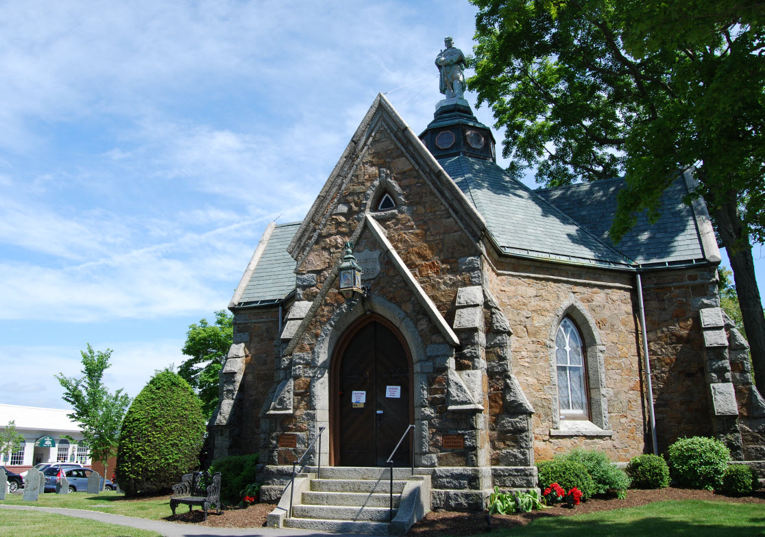
Memorial Hall
Monument and historic site · National Register of Historic Places
Building in Massachusetts, United States of America

Amos Morse House
Monument and historic site · National Register of Historic Places · 1.5 mi
House in Foxborough, Massachusetts

Capt. Josiah Pratt House
Monument and historic site · National Register of Historic Places · 2.4 mi
Foxboro, Massachusetts, listed on the NRHP in Norfolk County

Ezra Carpenter House
Monument and historic site · National Register of Historic Places · 0.9 mi
Historic house in Massachusetts, United States

Foxboro Grange Hall
Monument and historic site · National Register of Historic Places
Building in Massachusetts, United States

Foxborough Pumping Station
Monument and historic site · National Register of Historic Places · 1.1 mi
Historic district in Massachusetts, United States of America

Foxborough State Hospital
Monument and historic site · National Register of Historic Places · 1.1 mi
Former hospital

Otis Cary House
Monument and historic site · National Register of Historic Places · 1.4 mi
Historic house in Foxboro, Massachusetts, United States

Pondville Cemetery
Monument and historic site · National Register of Historic Places · 2.8 mi
Historic cemetery in Norfolk, Massachusetts, United States

Seth Boyden House
Monument and historic site · National Register of Historic Places · 1.7 mi
Historic house in Massachusetts, United States

Soldiers' Memorial Library
Monument and historic site · National Register of Historic Places · 3.2 mi
Historic library building in Mansfield, Massachusetts, United States


Spring Brook Cemetery
Monument and historic site · National Register of Historic Places · 3.3 mi
Historic cemetery in Massachusetts, United States
7 more on the map.
Parks, trails and playgrounds19





7 more on the map.
Restaurants and cafes5


South Street Pizzeria
Restaurant · Pizza
16 South Street, Foxborough
The Common’s Neighborhood Eatery
Restaurant
20 Central Street, Foxborough

History
Settled in 1704 and incorporated in 1778, the town of Foxborough was named for Charles James Fox, a Whig member of Parliament and a staunch supporter of the Colonies in the years leading up to the American Revolution.
The town was once home to the world's largest straw hat factory, erected in 1886. The building became the Bay State Boot and Shoe Company which closed in 1891. In 1894, the building became the Inman and Kimball hat factory. It burned to the ground during a spectacular mid-day fire in 1936. The Foxborough Post Office now stands on the site.
Foxborough was composed of small neighborhood communities until the early 1900s. These included Foxvale/Paineburgh, which remained semi-independent until the early twentieth century; Quaker Hill in South Foxborough; and Lakeview/Donkeyville in West Foxborough.
From the History section of Foxborough, Massachusetts on Wikipedia, under CC BY-SA 4.0.
Where to stay3
Churches and places of worship8
Shopping1
Gas and EV charging3
Schools, colleges and libraries37
Healthcare2
Map of Foxborough
102 places. The map loads OpenStreetMap tiles when you open it.
Climate by month
Monthly table
| Month | High | Low | Rain | Snow |
|---|---|---|---|---|
| Jan | 36°F | 18°F | 4.4 in | 14.3 in |
| Feb | 39°F | 19°F | 3.8 in | 12.6 in |
| Mar | 46°F | 26°F | 5.3 in | 10.1 in |
| Apr | 58°F | 35°F | 4.7 in | 1.9 in |
| May | 69°F | 46°F | 3.6 in | 0.0 in |
| Jun | 77°F | 55°F | 4.3 in | 0.0 in |
| Jul | 82°F | 62°F | 3.5 in | 0.0 in |
| Aug | 81°F | 60°F | 3.8 in | 0.0 in |
| Sep | 73°F | 52°F | 4.1 in | 0.0 in |
| Oct | 61°F | 41°F | 5.1 in | 0.2 in |
| Nov | 51°F | 32°F | 4.5 in | 1.2 in |
| Dec | 42°F | 24°F | 5.2 in | 9.2 in |
U.S. Climate Normals 1991-2020 for Norton W (6 mi away), NOAA NCEI.
People and cost of living
American Community Survey 5-year estimates, 2020-2024, U.S. Census Bureau. Estimates have margins of error, larger for small towns.
Disaster history
Norfolk County has had 25 federal disaster declarations since 2000, most often for snowstorms.
- 2023-09-15: Hurricane Lee (Hurricane)
- 2022-04-18: Severe Winter Storm And Snowstorm (Snowstorm)
- 2020-03-27: Covid-19 Pandemic (Biological)
- 2020-03-13: Covid-19 (Biological)
- 2018-07-19: Severe Winter Storm And Snowstorm (Snowstorm)
- 2018-06-25: Severe Winter Storm And Flooding (Severe Storm)
OpenFEMA disaster declarations summaries.
Getting there and nearby towns
Norwood Memorial Airport (OWD) is the nearest airport with scheduled flights listed in OpenStreetMap, 9 miles away.
- Norton Center 7 mi southeast, about 11 min by car
- North Attleborough Town 8 mi southwest, about 13 min by car
- Franklin Town 8 mi west, about 14 min by car
- Norwood 9 mi north, about 14 min by car
- Attleboro 9 mi south, about 15 min by car
- Brockton 12 mi east, about 19 min by car
- Valley Falls 12 mi southwest, about 20 min by car
- Randolph Town 13 mi northeast, about 21 min by car
- Dedham 13 mi north, about 21 min by car
- Taunton 14 mi southeast, about 22 min by car
Drive times are estimates from straight-line distance, not routes.
Local news
Headlines from INDB, the NEMICO news database.
Reviews, tips and questions
Loading what members have shared...
Sources and licences
- NCES EDGE (Public domain): public schools
- NOAA NCEI U.S. Climate Normals 1991-2020 (Public domain): climate by month
- OpenFEMA (Public domain): disaster declarations
- OpenStreetMap contributors (ODbL 1.0): places, airports, map data
- U.S. Census Bureau (Public domain): population, income, housing, education, commute
- Wikidata (CC0 1.0): elevation, founding date, time zone, website, landmarks and historic places
- Wikimedia Commons (see each image): photos
- Wikipedia (CC BY-SA 4.0): overview and history text
Photo credits
- Congregational Church, Foxborough MA, John Phelan, CC BY 3.0
- Framingham Secondary in Foxborough, August 2015, Pi.1415926535, CC BY-SA 3.0
- Former Foxborough station platform, August 2015, Pi.1415926535, CC BY-SA 3.0
- Foxborough, Massachusetts, Quintin Soloviev, CC BY 4.0
- Little Free Library, Foxborough MA, John Phelan, CC BY-SA 4.0
- Neponset Reservoir, Foxborough MA, John Phelan, CC BY-SA 4.0
- Foxborough Hall, Marcbela (Marc N. Belanger), Public domain
- SharonMA GavinsPondDam, User:Magicpiano, CC BY-SA 4.0
- NortonMA PondvilleCemetery, User:Magicpiano, CC BY-SA 4.0
- Foxborough state, Marcbela (Marc N. Belanger), Public domain
- FoxboroughMA AmosMorseHouse, User:Magicpiano, CC BY-SA 4.0
- Ezra Carpenter House, Foxborough MA, John Phelan, CC BY 3.0
- FoxboroughMA PumpingStation, User:Magicpiano, CC BY-SA 4.0
- Spring Brook Cemetery, Mansfield MA, John Phelan, CC BY 3.0
- Soldiers' Memorial Library, Mansfield Center MA, John Phelan, CC BY 3.0
- Foxboro Grange Hall, Foxborough MA, John Phelan, CC BY 3.0
- Otis Cary House, Foxborough MA, John Phelan, CC BY 3.0
- FoxboroughMA SethBoydenHouse, User:Magicpiano, CC BY-SA 4.0
- Streetcar on Central Street, Foxboro, 1909 postcard, Unknown author Unknown author, Public domain
- Patriots-Browns 2007, Bernard Gagnon, CC BY-SA 3.0
- Foxboro Common with streetcars postcard, Unknown author Unknown author, Public domain
- Gilette stadium "Patriots home", N662JB (6959468613), Eric Salard, CC BY-SA 2.0
- P1010002 (4118191622), Massachusetts Dept. of Environmental Protection, CC BY 2.0
- P1010003 (4118191652), Massachusetts Dept. of Environmental Protection, CC BY 2.0
- Foxboro streetcar trestle 1914 postcard, Unknown author Unknown author, Public domain


Page built October 30, 2026. Spotted a mistake? Tell us or suggest a place.