


North Attleborough Town, Massachusetts
North Attleborough Town is a city of 30,984 people in Bristol County, Massachusetts, founded in 1669.
Why visit North Attleborough Town
Townapedia lists 94 museums and landmarks, 78 parks and trails, 54 places to eat, 2 places to stay and 15 attractions in and around town.
Highlights include Showcase Cinema de Lux North Attleboro, Diamond Hill, Angle Tree Stone and Arnold Mills Historic District.
July is the warmest month, with average highs of 84°F; January lows average 19°F, and about 42 inches of snow fall in a normal year.
Weather in North Attleborough Town
Forecast from the National Weather Service. Full forecast
About North Attleborough Town
North Attleborough, alternatively spelled North Attleboro, is a city in Bristol County, Massachusetts, United States. The population was 30,834 at the 2020 census.
From the Wikipedia article North Attleborough, Massachusetts (this version), under CC BY-SA 4.0.
Things to do15


Route One Cinema Pub
Cinema and theater · 1.0 mi
652 East Washington Street, North Attleborough

3 more on the map.
Museums and landmarks94

Angle Tree Stone
Monument and historic site · National Register of Historic Places · 1.8 mi
United States historic place
Arnold Mills Historic District
Monument and historic site · National Register of Historic Places · 3.1 mi
Historic district in Cumberland, Rhode Island

Falls Fire Barn Museum
Monument and historic site · National Register of Historic Places · 1.1 mi
United States historic place in North Attleborough, Massachusetts
100 Commonwealth Avenue
Herbert A. Sadler House
Monument and historic site · National Register of Historic Places · 3.5 mi
Attleboro, Massachusetts, listed on the NRHP in Bristol County

Ashton Historic District
Monument and historic site · National Register of Historic Places · 5.5 mi
United States historic place

Attleboro station
Monument and historic site · National Register of Historic Places · 3.3 mi
Railway station in Attleboro, Massachusetts
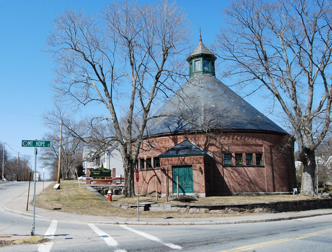
Attleborough Falls Gasholder Building
Monument and historic site · National Register of Historic Places · 0.8 mi
Building in Massachusetts, United States

Attleborough Falls Historic District
Monument and historic site · National Register of Historic Places · 0.9 mi
Historic district in Massachusetts, United States

Berkeley Mill Village
Monument and historic site · National Register of Historic Places · 5.3 mi
Cumberland (Berkeley), RI, listed on the NRHP in Rhode Island


Blackinton Houses and Park
Monument and historic site · National Register of Historic Places · 2.6 mi
Historic houses in Massachusetts, United States
Capron House
Monument and historic site · National Register of Historic Places · 2.2 mi
Historic house in Massachusetts, United States
Capt. Joel Robinson House
Monument and historic site · National Register of Historic Places · 2.2 mi
Attleboro, Massachusetts, listed on the NRHP in Bristol County, Massachusetts
82 more on the map.
Parks, trails and playgrounds78

Capron Park Zoo
Park · 3.0 mi
Zoo in Attleboro, Massachusetts
201 County Street, Attleboro



Harold Burns Memorial Wildlife Arboretum
Park · 1.9 mi
Mount Hope Street, North Attleboro
Jolly Cholly's Funland
Sports field and stadium
171 East Washington Street, North Attleboro
66 more on the map.
Restaurants and cafes54

Box Seats
Restaurant · American, Burger, Pizza · 0.8 mi
500 East Washington Street
Su-We 11:00-22:00; Th-Sa 11:00-23:00

Golden Dragon
Restaurant · Chinese · 3.5 mi
217 South Main Street, Attleboro
Mo 15:30-20:30; We-Th 11:00-20:30; Fr-Sa 11:00-21:30; Su 12:00-20:30
KC’s Classic Burger Bar
Restaurant · Burger · 1.1 mi
625 East Washington Street
Su-Th 11:30-21:00; Fr-Sa 11:30-22:00
Babe's Restaurant
Restaurant · Breakfast, Lunch, Burger, Pancake, Sandwich · 3.0 mi
11 Washington Street, South Attleboro
Mo-Su 07:00-15:00

42 more on the map.
History
In pre-Colonial times, the land was the site of the Bay Path, a major Native American trail to Narragansett Bay, the Seekonk River, and Boston. English settlers arrived in the area in 1634 and established the settlement of Rehoboth—which included the modern day municipalities of North Attleborough, Attleboro, Somerset, Seekonk, as well as parts of Rhode Island—from land sold to them by the Pokanoket Wamsutta. John Woodcock established a settlement in the territory in 1669 which subsisted on agriculture, fishing and hunting. By 1670, Woodcock had received a license to open a tavern. The settlement was attacked during King Philip's War, with two killed and one home burned, but the Garrison house which Woodcock had built survived the attack. The Woodcock-Garrison house was used as sleeping quarters for George Washington on his army's march to Boston to rid the city of General Thomas Gage's troops.
The Town of Attleborough was incorporated from this territory in 1694.
From the History section of North Attleborough, Massachusetts on Wikipedia, under CC BY-SA 4.0.
Where to stay2
Best Western North Attleboro / Providence Beltway
Motel and hotel · 0.9 mi
707 South Washington Street, North Attleboro
Churches and places of worship12
First Parsonage for Second East Parish Church
Church · National Register of Historic Places · 3.2 mi
St. Joseph's Church Complex
Church · National Register of Historic Places · 5.4 mi
Good Shepherd Lutheran Church
Church · Lutheran · 3.4 mi
60 May Street, Attleboro
Shopping12
Gas and EV charging16
Schools, colleges and libraries67
Healthcare3
Map of North Attleborough Town
250 places. The map loads OpenStreetMap tiles when you open it.
Climate by month
Monthly table
| Month | High | Low | Rain | Snow |
|---|---|---|---|---|
| Jan | 38°F | 19°F | 4.4 in | 12.3 in |
| Feb | 40°F | 21°F | 3.7 in | 10.7 in |
| Mar | 47°F | 28°F | 4.9 in | 7.6 in |
| Apr | 60°F | 38°F | 4.7 in | 1.9 in |
| May | 70°F | 48°F | 3.6 in | 0.0 in |
| Jun | 78°F | 57°F | 4.3 in | 0.0 in |
| Jul | 84°F | 63°F | 3.6 in | 0.0 in |
| Aug | 82°F | 62°F | 4.0 in | 0.0 in |
| Sep | 75°F | 54°F | 4.2 in | 0.0 in |
| Oct | 64°F | 42°F | 5.1 in | 0.1 in |
| Nov | 53°F | 33°F | 4.2 in | 1.0 in |
| Dec | 43°F | 25°F | 5.3 in | 7.9 in |
U.S. Climate Normals 1991-2020 for Woonsocket (8 mi away), NOAA NCEI.
People and cost of living
American Community Survey 5-year estimates, 2020-2024, U.S. Census Bureau. Estimates have margins of error, larger for small towns.
Disaster history
Bristol County has had 23 federal disaster declarations since 2000, most often for severe storms.
- 2024-05-15: Severe Storms And Flooding (Flood)
- 2023-09-15: Hurricane Lee (Hurricane)
- 2022-04-18: Severe Winter Storm And Snowstorm (Snowstorm)
- 2020-03-27: Covid-19 Pandemic (Biological)
- 2020-03-13: Covid-19 (Biological)
- 2018-06-25: Severe Winter Storm And Flooding (Severe Storm)
OpenFEMA disaster declarations summaries.
Getting there and nearby towns
North Central State Airport (SFZ) is the nearest airport with scheduled flights listed in OpenStreetMap, 9 miles away.
- Attleboro 3 mi southeast, about 5 min by car
- Franklin Town 9 mi northwest, about 14 min by car
- Providence 11 mi southwest, about 18 min by car
- Milford 15 mi northwest, about 25 min by car
- Brockton 18 mi northeast, about 28 min by car
- Bridgewater Town 18 mi east, about 29 min by car
- Fall River 21 mi southeast, about 34 min by car
- Dedham 21 mi northeast, about 33 min by car
- Holbrook 21 mi northeast, about 34 min by car
- Needham 22 mi north, about 35 min by car
Drive times are estimates from straight-line distance, not routes.
Local news
Headlines from INDB, the NEMICO news database.
Reviews, tips and questions
Loading what members have shared...
Sources and licences
- NCES EDGE (Public domain): public schools
- NOAA NCEI U.S. Climate Normals 1991-2020 (Public domain): climate by month
- OpenFEMA (Public domain): disaster declarations
- OpenStreetMap contributors (ODbL 1.0): places, airports, map data
- U.S. Census Bureau (Public domain): population, income, housing, education, commute
- Wikidata (CC0 1.0): elevation, founding date, time zone, website, landmarks and historic places
- Wikimedia Commons (see each image): photos
- Wikipedia (CC BY-SA 4.0): overview and history text
Photo credits
- North Attleborough Town hall, Marcbela (Marc N. Belanger), Public domain
- CumberlandRI ArnoldMillsVillage 1, User:Magicpiano, CC BY-SA 4.0
- AttleboroMA HerbertASadlerHouse, User:Magicpiano, CC BY-SA 4.0
- Falls Fire Barn, Attleborough Falls MA, John Phelan, CC BY 3.0
- Former site of Patterson Brothers Commercial Building Cumberland RI, Kenneth C Zirkel, CC BY-SA 3.0
- CumberlandRI WhippleJenckesHouse, User:Magicpiano, CC BY-SA 4.0
- Colonel Blackinton Inn, Attleboro MA, John Phelan, CC BY 3.0
- CumberlandRI FranklinFarm, User:Magicpiano, CC BY-SA 4.0
- Hebronville Mill, Marcbela (Marc N. Belanger), Public domain
- Berkeley Mill RI, Marcbela (Marc N. Belanger), Public domain
- NorthAttleboroughMA FirstCongregationalChurch, User:Magicpiano, CC BY-SA 4.0
- Henry E. and Abigail Arnold House, Attleborough Falls MA, John Phelan, CC BY 3.0
- MBTA Providence Line train 851 at Attleboro October 2025, 4300streetcar, CC BY 4.0
- Cumberland Town Hall RI, Marcbela (Marc N Belanger), Public domain
- The Codding Farm, North Attleborough MA, John Phelan, CC BY 3.0
- North Attleborough Center, Marcbela (Marc N. Belanger), Public domain
- Ashton Mill Village, Marcbela (Marc N. Belanger), Public domain
- CumberlandRI JohnColeFarm, User:Magicpiano, CC BY-SA 4.0
- NorthAttleboro SecondChurchParsonage, Elizabeth Phillips, Public domain
- LincolnRI OldAshton KelleyHouse BlackstoneCanal, User:Magicpiano, CC BY-SA 4.0
- 102 South Washington Street North Attleborough, Marcbela (Marc N. Belanger), Public domain
- Rector's house St Josephs Church, Kenneth C. Zirkel, CC BY-SA 3.0
- CumberlandRI LewisTowerHouse, Magicpiano, CC BY-SA 3.0
- Old Attleboro, MA, post office, Daniel Case, CC BY-SA 3.0
- NorthAttleboroughMA SouthWashingtonHD 02, User:Magicpiano, CC BY-SA 4.0
- AttleboroMA DodgevilleMill2, Magicpiano, CC BY-SA 4.0
- Attleborough Falls Gasholder, Marcbela (Marc N. Belanger), Public domain
- 188 Commonwealth Avenue, Attleborough Falls MA, John Phelan, CC BY 3.0
- Woodcock-Hatch-Maxcy House, North Attleborough MA, John Phelan, CC BY 3.0
- Benjamin Stanley Freeman Home, Attleborough Falls MA, John Phelan, CC BY 3.0
- NorthAttleboroughMA 224TowneStreet, User:Magicpiano, CC BY-SA 4.0
- LincolnRI Lonsdale WorkerHousing2, User:Magicpiano, CC BY-SA 4.0
- East Attleborough Academy, Attleboro MA, John Phelan, CC BY 3.0
- Jolly Cholly's miniature golf, Rhododendrites, CC BY-SA 4.0
- 211 S Washington St, N Attleboro MA.9May2021, Galligant, CC BY-SA 4.0
- Wrentham Branch abutment at Roosevelt Avenue, June 2021, Pi.1415926535, CC BY-SA 4.0
- Former Chestnut Street station in North Attleborough, June 2017, Pi.1415926535, CC BY-SA 4.0
- Postcard of streetcar and Attleboro Savings Bank in North Attleborough, Unknown author Unknown author, Public domain
- Grace Episcopal Church, North Attleborough, Massachusetts, Kenneth C. Zirkel, CC BY-SA 4.0
- Richards Memorial Library, North Attleborough, Massachusetts, Kenneth C. Zirkel, CC BY-SA 4.0


Page built October 30, 2026. Spotted a mistake? Tell us or suggest a place.