


Moosic, Pennsylvania
Moosic is a borough of 5,973 people in Lackawanna County, Pennsylvania, founded in December 9, 1898.
Why visit Moosic
Townapedia lists 35 museums and landmarks, 20 parks and trails, 45 places to eat, 9 places to stay and 9 attractions in and around town.
Highlights include Cinemark Montage Mountain 20 and XD, Scranton Cultural Center, Ad-Lin Building and Albright Memorial Building.
July is the warmest month, with average highs of 85°F; January lows average 20°F, and about 45 inches of snow fall in a normal year.
Weather in Moosic
Forecast from the National Weather Service. Full forecast
About Moosic
Moosic is a borough in Lackawanna County, Pennsylvania, United States, 3 miles (5 km) south of downtown Scranton and 10 miles (16 km) northeast of downtown Wilkes-Barre, on the Lackawanna River.
From the Wikipedia article Moosic, Pennsylvania (this version), under CC BY-SA 4.0.
Things to do9

Cinemark Montage Mountain 20 and XD
Cinema and theater · 1.0 mi
40 Glenmaura National Boulevard, Moosic
Scranton Cultural Center
Cinema and theater · National Register of Historic Places · 4.0 mi
Theater in Scranton, Pennsylvania, USA

Luna Park, Scranton
Monument and historic site · 4.1 mi
Amusement park in Scranton, New Jersey, U.S

Montage Mountain
Ski area · 2.0 mi
Ski resort in Scranton, Pennsylvania, United States

Rocky Glen Park
Monument and historic site · 0.7 mi
Closed entertainment venue in Moosic, Pennsylvania
Toyota Pavilion at Montage Mountain
Cinema and theater · 1.9 mi
Outdoor theater in Scranton, Pennsylvania

University of Scranton
School · 3.8 mi
Private Jesuit university in Scranton, Pennsylvania, USA
The Pavilion at Montage Mountain
Cinema and theater · 2.0 mi
Montage Mountain Road, Scranton
Museums and landmarks35

Ad-Lin Building
Monument and historic site · National Register of Historic Places · 3.8 mi
Historic commercial building in Scranton, Pennsylvania, United States

Albright Memorial Building
Monument and historic site · National Register of Historic Places · 4.1 mi
Library in Scranton, Pennsylvania

Century Club of Scranton
Monument and historic site · National Register of Historic Places · 4.2 mi
Building in Pennsylvania, United States

Delaware, Lackawanna and Western Railroad Yard-Dickson Manufacturing Co. Site
Monument and historic site · National Register of Historic Places · 3.5 mi
Historic district in Pennsylvania, United States

Dickson Works
Monument and historic site · National Register of Historic Places · 4.1 mi
Historic industrial building in Scranton, Pennsylvania, United States

Dime Bank Building
Monument and historic site · National Register of Historic Places · 3.7 mi
Scranton, Pennsylvania

Finch Building
Monument and historic site · National Register of Historic Places · 4.0 mi
Historic place in Pennsylvania, United States

Florence Apartments
Monument and historic site · National Register of Historic Places · 4.2 mi
Multifamily residential in Pennsylvania, United States of America
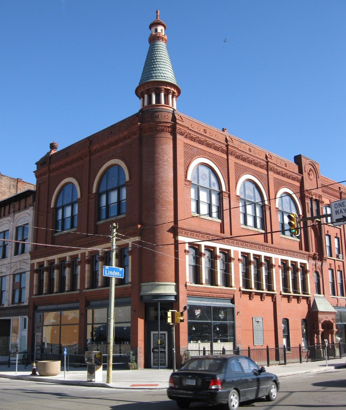
Grand Army of the Republic Building
Monument and historic site · National Register of Historic Places · 3.9 mi
Building in Pennsylvania, United States

Harrison Avenue Bridge
Bridge · National Register of Historic Places · 3.7 mi
Bridge in United States of America
James L. Crawford House
Monument and historic site · National Register of Historic Places · 3.9 mi
Former house in Scranton, Pennsylvania, USA

Lackawanna Avenue Commercial Historic District
Monument and historic site · National Register of Historic Places · 3.7 mi
Historic district in Scranton, Pennsylvania, United States
23 more on the map.
Parks, trails and playgrounds20

McDade Park
Park · 4.0 mi
Community park and arboretum in Scranton and Taylor, Lackawanna County in northeastern Pennsylvania, United States


Nay Aug Park
Park · 4.0 mi
Public park in Scranton, Pennsylvania, United States




8 more on the map.
Restaurants and cafes45

Dino & Francesco's
Restaurant · Italian Pizza · 1.1 mi
3305 Birney Avenue, Moosic
Mo-Sa 10:00-21:00; Su 11:00-21:00
Food & Fire BBQ~Taphouse
Restaurant · Barbecue · 1.1 mi
7041 Shoppes Boulevard, Moosic
Mo-Tu 15:00-21:00; We,Th 12:00-21:00; Fr,Sa 12:00-22:00; Su 12:00-20:00
Harvest Seasonal Grill & Wine Bar
Restaurant · 1.1 mi
7011 Shoppes Boulevard, Moosic
Mo 15:00-21:00; Tu-Th 11:30-21:00; Fr,Sa 11:30-22:00; Su 11:00-20:00

Lucky's Craft Food and Drink
Diner · American · 2.2 mi
Only accessible after TSA check.
100 Terminal Road, Pittston
Mo-Sa 05:00-19:00; Su 09:00-19:00


33 more on the map.
History
The name "Moosic" probably derives from the Unami language of the Lenape people, meaning "elk place". The Lenape, a Native American people, are the earliest-known inhabitants of Moosic. The borough was incorporated on December 9, 1898. Before incorporation, the villages of Moosic and Greenwood had been a part of Lackawanna Township. From 1886 to 1987, Moosic was the site of Rocky Glen Park, an amusement park. The former grounds are now a Pennsylvania state historical marker.
From the History section of Moosic, Pennsylvania on Wikipedia, under CC BY-SA 4.0.
Where to stay9
Courtyard Scranton Montage Mountain
Motel and hotel · 0.7 mi
16 Glenmaura National Boulevard, Scranton
Churches and places of worship19
First Church of Christ, Scientist
Church · National Register of Historic Places · 3.9 mi
St. Peter's Cathedral
Church · National Register of Historic Places · 3.9 mi
Moosic Alliance Community Church
Church · Christian And Missionary Alliance · 0.4 mi
608 Rocky Glen Road, Avoca
Saints Francis And Clare Progressive Catholic Church
Church · Progressive Catholic · 0.9 mi
3343 Greenwood Avenue, Moosic
First Congregational United Church of Christ
Church · United Church Of Christ · 1.9 mi
130 Union Street, Taylor
Moosic Assembly of God
Church · Assemblies Of God · 1.8 mi
477 3rd Street, Moosic
Shopping9
Old Forge Shopping Center
Shopping center · 2.2 mi
405 South Main Street, Old Forge
Gas and EV charging8
Schools, colleges and libraries33
Riverside Junior Senior High School
School · 1.9 mi
310 Davis Street, Taylor
Howard Gardner Multiple Intelligence Cs
School · 3.0 mi
1615 East Elm Street, Scranton
Martin F Quinn Pittston Area Primary Ctr
School · 4.2 mi
210 Rock Street, Pittston
Map of Moosic
187 places. The map loads OpenStreetMap tiles when you open it.
Climate by month
Monthly table
| Month | High | Low | Rain | Snow |
|---|---|---|---|---|
| Jan | 36°F | 20°F | 2.6 in | 11.7 in |
| Feb | 39°F | 22°F | 2.1 in | 10.9 in |
| Mar | 48°F | 29°F | 2.8 in | 10.1 in |
| Apr | 61°F | 39°F | 3.3 in | 0.8 in |
| May | 72°F | 50°F | 3.3 in | 0.0 in |
| Jun | 80°F | 58°F | 3.8 in | 0.0 in |
| Jul | 85°F | 63°F | 3.6 in | 0.0 in |
| Aug | 82°F | 61°F | 3.9 in | 0.0 in |
| Sep | 75°F | 54°F | 4.2 in | 0.0 in |
| Oct | 63°F | 43°F | 3.7 in | 0.7 in |
| Nov | 51°F | 34°F | 2.9 in | 3.2 in |
| Dec | 40°F | 26°F | 2.8 in | 7.7 in |
U.S. Climate Normals 1991-2020 for Wilkes-Barre Intl Ap 72513 (2 mi away), NOAA NCEI.
People and cost of living
American Community Survey 5-year estimates, 2020-2024, U.S. Census Bureau. Estimates have margins of error, larger for small towns.
Disaster history
Lackawanna County has had 13 federal disaster declarations since 2000, most often for severe storms.
- 2020-03-30: Covid-19 Pandemic (Biological)
- 2020-03-13: Covid-19 (Biological)
- 2018-11-27: Severe Storms And Flooding (Severe Storm)
- 2012-10-29: Hurricane Sandy (Hurricane)
- 2011-09-12: Tropical Storm Lee (Flood)
- 2011-09-08: Remnants Of Tropical Storm Lee (Flood)
OpenFEMA disaster declarations summaries.
Getting there and nearby towns
Wilkes-Barre/Scranton International Airport (AVP) is the nearest airport with scheduled flights listed in OpenStreetMap, 2 miles away.
- Avoca 3 mi southwest, about 4 min by car
- Scranton 3 mi northeast, about 6 min by car
- Dupont 3 mi southwest, about 5 min by car
- Duryea 4 mi west, about 7 min by car
- Hughestown 4 mi southwest, about 7 min by car
- Browntown 5 mi southwest, about 9 min by car
- Dunmore 6 mi northeast, about 10 min by car
- Exeter 7 mi west, about 11 min by car
- Laflin 7 mi southwest, about 11 min by car
- Dickson City 8 mi northeast, about 13 min by car
Drive times are estimates from straight-line distance, not routes.
Local news
Headlines from INDB, the NEMICO news database.
Reviews, tips and questions
Loading what members have shared...
Sources and licences
- NCES EDGE (Public domain): public schools
- NOAA NCEI U.S. Climate Normals 1991-2020 (Public domain): climate by month
- OpenFEMA (Public domain): disaster declarations
- OpenStreetMap contributors (ODbL 1.0): places, airports, map data
- U.S. Census Bureau (Public domain): population, income, housing, education, commute
- Wikidata (CC0 1.0): elevation, founding date, time zone, website, landmarks and historic places
- Wikimedia Commons (see each image): photos
- Wikipedia (CC BY-SA 4.0): overview and history text
Photo credits
- Moosic PA Muni Building, Smallbones, CC0
- Southeastern Greenwood Moosic Pennsylvania, Gt59514, CC0
- US 11 sb entering Moosic, PA, Sept. 2023, Mr. Matté (if there is an issue with this image, contact me using this image's Commons talk page , my Commons user talk page , or my English Wikipedia user talk page ; I'll know about it a lot faster), CC BY-SA 4.0
- Moosic, PA Presbyterian Church, Feb. 2026, Mr. Matté (if there is an issue with this image, contact me using this image's Commons talk page , my Commons user talk page , or my English Wikipedia user talk page ; I'll know about it a lot faster), CC BY-SA 4.0
- Moosic, PA Methodist Church, Feb. 2026, Mr. Matté (if there is an issue with this image, contact me using this image's Commons talk page , my Commons user talk page , or my English Wikipedia user talk page ; I'll know about it a lot faster), CC BY-SA 4.0
- US 11 sb in Moosic, PA, Sept. 2023, Mr. Matté (if there is an issue with this image, contact me using this image's Commons talk page , my Commons user talk page , or my English Wikipedia user talk page ; I'll know about it a lot faster), CC BY-SA 4.0
- Main Street eb, Moosic, PA, Feb. 2026, Mr. Matté (if there is an issue with this image, contact me using this image's Commons talk page , my Commons user talk page , or my English Wikipedia user talk page ; I'll know about it a lot faster), CC BY-SA 4.0
- Century Club Scranton PA, Smallbones, CC0
- Harrison Avenue Bridge - March 2015, Adam Moss, CC BY-SA 2.0
- Lackawanna County Courthouse Nov 09, Doug Kerr from Albany, NY, United States, CC BY-SA 2.0
- St. Peter's Cathedral, Christopher Seliga, CC BY-SA 3.0
- Roger Williams Public School No 10 Scranton PA, Smallbones, CC0
- Ad-Lin bldg Scranton PA, Smallbones, CC0
- Central Railroad of New Jersey Freight Station, Scranton, PA, Daniel Case, CC BY-SA 3.0
- Dime Bank 2 Scranton PA, Smallbones, CC0
- PA-Scranton 1931 1 Ref, General Services Administration, Public domain
- Christian Science Scranton PA, Smallbones, CC0
- Main station D,L & W Scranton PA, Smallbones, CC0
- Florence Apts Scranton PA, Smallbones, CC0
- Finch Building, Scranton, PA, Daniel Case, CC BY-SA 3.0
- Scranton - Scranton City Hall (48472742281), Ajay Suresh from New York, NY, USA, CC BY 2.0
- Scranton iron furnaces 2008 03 23, Rolfmueller, CC BY-SA 4.0
- Steamtown Roundhouse, National Park Service, Public domain
- 332-334 Lackawanna Avenue, Scranton, Mark Harrell, Public domain
- Grand Army of the Republic Building Scranton PA Nov 09, Doug Kerr from Albany, NY, United States, CC BY-SA 2.0
- Dickson Works Nov 09, Doug Kerr from Albany, NY, United States, CC BY-SA 2.0
- Delaware, Lackawanna and Western Railroad Yard, Scranton, Mark Harrell, Public domain
- Terence Powderly House, Daniel Case, CC BY-SA 3.0
- Scranton, PA, Public Library IMG 1519, Billy Hathorn ( talk ), CC BY-SA 3.0
- Madison School Scranton PA, Smallbones, CC0
- 426 Mulberry Street Scranton PA, Smallbones, CC0
- Anthracite Heritage Museum in Scranton, PA IMG 1591, Billy Hathorn ( talk ), CC BY-SA 3.0
- U of Scranton - The Commons, Scanlan of English Wikipedia, Public domain
- Everhart Museum and Nay Aug Park, Scranton, Pa (79587), The Mebane Greeting Card Co., Wilkes-Barre, PA., Public domain
- Everhart Museum, Jeffrey from Dunmore, PA, CC BY-SA 2.0
- Ststanislauscathedral, Tomdobb, CC BY-SA 3.0
- Montage Mountain Aerial View, Montage Mountain Resorts, CC BY-SA 4.0
- McDade Park, Scranton, PA IMG 1552, Billy Hathorn ( talk ), CC BY-SA 3.0
- Scranton-Wilkes Barre RailRiders vs. Syracuse Mets, August 12, 2023, JJonahJackalope, CC BY-SA 4.0
- Scranton-Wilkes Barre RailRiders vs. Syracuse Mets, August 12, 2023, rained out, JJonahJackalope, CC BY-SA 4.0


Page built October 30, 2026. Spotted a mistake? Tell us or suggest a place.